WeatherNLU
Meteorologist

Reged: Sat
Posts: 212
Loc: New Orleans, LA
|
|
168HR ..........not good. BIG HURRICANE in a BAD SPOT. (See attachment).
228HR has a signifigant hurricane making landfall on the Central/Western Louisiana coast. (Valid 08/24).
Obviously just food for thought at this point, the main idea being that a track more through the Caribbean and not north of the islands is taking shape.
--------------------
I survived Hurricane Katrina, but nothing I owned did!
|
Hugh
Senior Storm Chaser
Reged: Fri
Posts: 1060
Loc: Okaloosa County, Florida
|
|
Quote:
If the 5 day forecast of the holds as now shown, I see no way how Dean stays out of the GOM.
Yuck!
It is *possible* that Dean never makes THE TURN, and plows into Central America. The high in the SE that it giving us this oppressive weather and pushing TD 5 into Texas could keep Dean out of the picture.
Having said that, I don't expect it to - prepare for the worst, and it won't happen, they say. In 3-4 days we should know more, hopefully, but right now I think it's certainly not unreasonable to expect a Cat 3-4 (or higher) hurricane in the central GOM in the long term.
--------------------
Hugh
Eloise (1975) - Elena and several other near misses (1985) - Erin & Opal (1995) - Ivan (2004)
|
madmumbler
Storm Tracker

Reged: Wed
Posts: 324
Loc: SWFL
|
|
Quote:
168HR ..........not good. BIG HURRICANE in a BAD SPOT.
228HR has a signifigant hurricane making landfall on the Central/Western Louisiana coast. (Valid 08/24).
Obviously just food for thought at this point, the main idea being that a track more through the Caribbean and not north of the islands is taking shape.
Again I say, it doesn't matter where at this point it will hit -- EVERYONE should be making their early preparations at this point, regardless of where they are. THIS is the time to check plywood, window shutters, etc., go to the store, try to start the generator, all of that.
Do NOT wait until the declares a hurricane watch to do all of this. At that point, EVERYONE will be trying to do it. NOW is the time to prepare.
Also, important reminder, if you have pets, make SURE you go through your evacuation plan and have all arrangements in place to ensure their safe evacuation if you leave! Many municipalities/counties are now creating pet-friendly evacuation shelters, BUT usually only for dogs and cats, and you have to have current vet paperwork. DO IT NOW.
Dean is coming SOMEWHERE. So prepare now and if you don't need it, fine.
--------------------
Lesli in SWFL.
Friends help you move. Real friends help you move bodies.
|
OUSHAWN
Weather Guru
Reged: Tue
Posts: 101
Loc: Clear Lake,Tx
|
|
Man, sure is hard to believe from looking at the latest satellite pics that we are still talking about a 30mph depression in the GOM. That thing has exploded with deep convection. I think the Hunters are on their way back out to the system. I'll be surprised if they don't find this to be a tropical storm now. I still feel the watches will have to be extended north into the Houston/Galveston area.
Shawn
|
stevie
Verified CFHC User

Reged: Mon
Posts: 13
Loc: Clear Lake, Texas
|
|
I agree with you Shawn about the growth, however I think the National Hurricane Center is being careful about scaring the Hou/Gal area since TD #5 has little room left before hitting land. Also the local METS /media seem to be a little behind in the info department.
|
LisaC
Weather Watcher
Reged: Wed
Posts: 39
|
|
Does anyone know what the coordinates are for the Herbert's boxes?
|
h2ocean
Weather Hobbyist

Reged: Fri
Posts: 91
Loc: South Merritt Island, FL
|
|
Here is a link about the Herbert Box, shows a graphic, but didn't see the actual coordinates.
http://www.hurricanecity.com/hebertbox.htm
Also, I know we have two active systems, but check out the wave behind Dean. It has started to fire some convection around a spinning area.
http://www.ssd.noaa.gov/goes/east/catl/loop-vis.html
--------------------
Merritt Island, FL Home Weather Station
|
SeaMule
Weather Hobbyist

Reged: Wed
Posts: 64
Loc: Fairhope, Al...on the coast
|
|
the thing noteworthy to me, and perhaps not mentioned, but additionally not overlooked, I'm sure...is the fact that Dean is slowing down a bit...as he is strengthening.
edited by moderator to remove statements seen as wishcasting
Edited by RedingtonBeachGuy (Wed Aug 15 2007 10:39 AM)
|
Beaumont, TX
Storm Tracker
Reged: Tue
Posts: 318
|
|
TD 5 does look better this morning. Will be interesting to see what they fine. I was also thinking they might have to extend the
watch to the Houston/Galveston area also. Southeast Texas actually needs rain but of course, no one needs another Allison.
|
Random Chaos
Weather Analyst

Reged: Sat
Posts: 1024
Loc: Maryland
|
|
We have 2 recons scheduled for the GOM system (TD5) today and 1 recon for it tomorrow.
We have 2 recons scheduled for Dean tomorrow.
----
Quickscat looks impressive for Dean still, but the satellite presentation isn't as good - definately looks to have been affected by some dry air. Even so, Dean has a tightly wound core right now with microwave imagery showing deep convection wrapping most of the way around. I would expect it to make hurricane today.
Meanwhile TD5 looks sheared, with the main convection not over where the quickscat shows the rotation to be located. We need a few more satellite overpasses, though, for other imagery: nothing good for over 6 hours.
----
References:
Quickscat
Microwave imagery: NRL SSMIS overpass 85GHz.
|
OUSHAWN
Weather Guru
Reged: Tue
Posts: 101
Loc: Clear Lake,Tx
|
|
I'm thinking the circulation on TD#5 may have reformed under all the deep convection. I just can't seem to find what would be causing shear to it.
Shawn
|
Random Chaos
Weather Analyst
Reged: Sat
Posts: 1024
Loc: Maryland
|
|
I agree.
Nothing should be shearing it, but the deep convection is displaced from the storm center, meaning there is either shear, or the center isn't where it appears to be.
However, that convection that occurred overnight with TD5 looked impressive.
|
OUSHAWN
Weather Guru
Reged: Tue
Posts: 101
Loc: Clear Lake,Tx
|
|
Well, I guess when RECON gets out there it will hopefully help to clear it up. I wonder if they may find that it has formed a new center under the convection,though. Just speculation on my part I guess.
Shawn
|
native
Weather Guru

Reged: Tue
Posts: 148
Loc: SE Florida
|
|
Quote:
Does anyone know what the coordinates are for the Herbert's boxes?
Other than the one at the hurricanecity site....this was the best I could find for box 1, I was unable to locate anything similar for box 2. Hope this helps you out.
Herbert's Box
As an aside, I'm not sure how accurate this image is as it looks to be a little larger than the actual box, but, it's a pretty fair assessment. Herbert's box is approximately 335mi. X 335mi. It is 69.2mi. between each degree of both longitude and latitude, which means the box is not quite 5 x 5 longitudinal/latitudinal degrees. (ie 15N to 20N and 60W to 65W.) Technically, the box is 4.84 x 4.84 lonitudinal/latitudinal degrees.
|
Ricreig
User

Reged: Sat
Posts: 431
Loc: Orlando, Fl
|
|
Quote:
Does anyone know what the coordinates are for the Herbert's boxes?
There are actually two boxes.
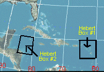
Box 1 is approx 15N to 20N by 60W to 65W and
Box 2 is approx 15N to 20N by 80W to 85W.
It does appear that Dean will graze one or both of those boxes unless it turns.
--------------------
Richard
A forecast is NOT a promise!
|
allan
Weather Master

Reged: Thu
Posts: 468
Loc: Palm Coast, Florida
|
|
At 11:00 advisory Dean may very well be very near to hurricane strength. Navy has winds up to 60 mph. (50 knts), this storm is so small in size but wow when you look at the visible, looks liek a minimal hurricane already! With such a small scale storm really gets me thinking about it's potential. The smaller the storm, greater will be the impact, think about in 2004, was a small category 4, done a big amount of damage. Andrew was another one, best example actually, very small category 5 storm, brought the worst damage until came on board. So really think about Deans potential, I believe a category 5 hurricane is possible in a couple of days, especially as it heads in the GOM
--------------------
Allan Reed - 18,9,5
|
Thunderbird12
Meteorologist
Reged: Thu
Posts: 644
Loc: Oklahoma
|
|
The plane has been out in TD5 for awhile now and still no vortex message. I'm not used to interpreting the HD recon obs, but it appears that there may be more than one candidate for a LLC. None of the flight-level winds thus far indicate anything stronger than a depression.
The satellite presentation does seem to be improving, with some banding features noted and also improving outflow. It is running out of time to do anything significant, though, especially considering it's apparent difficulty in establishing a well-defined low-level center.
Update: At 1433 UTC (10:33 EDT), the plane reported flight-level winds of 42 knots, which would be pushing tropical storm strength when the typical wind reduction to the surface is applied.
Edited by Thunderbird12 (Wed Aug 15 2007 10:51 AM)
|
Random Chaos
Weather Analyst
Reged: Sat
Posts: 1024
Loc: Maryland
|
|
We have a new thread 
|
sharkman
Registered User
Reged: Wed
Posts: 1
|
|
Please people read the summary of the Hebert Boxes

So what does all this mean when a Hurricane passes or develops in the Hebert Box east of Puerto Rico since 1950?
1)N Carolina has as much of a chance to get hit as Florida.
2)20.58% or most go out to sea without hitting land.
3)Only 8.82% make it into the Gulf of Mexico when they pass through the box as a hurricane.
4)Puerto Rico will get hit 20.58% of the time (the highest outside of n Antilles).
What about Box #2,Hurricanes developing or moving through after Oct 1st since 1950?
Cuba & the Bahamas are at highest risk late in the season.
To wrap things up, two significant Hurricanes that hit South Fla did not pass through this box, Andrew 1992, and Betsy 1965!. Data may be slightly off because these boxes were based on data going back to 1900. We chose named storms since 1950 for recognition purposes.
I grew up in Miami from the early 1950's and now live in Tampa Before Andrew which did not go through the Boxes there was nothing for 20 years only in the mid fifties and through the sixties did Miami get hit much less most of the state. 
Edited by sharkman (Wed Aug 15 2007 08:56 PM)
|


 Threaded

 [Re:
[Re: 


