MikeC
Admin
Reged: Sun
Posts: 4543
Loc: Orlando, FL
|
|
4:55 PM Update 19 August 2007
Images of Dean as it skirts south of Jamaica:
The models have diverged a bit this afternoon, mostly to the south, the 's forecast is actually a little north of most of the models now. Belize may have to watch out for Dean.


Dean is approaching South of Jamaica now, and already trees and power down are being reported in Jamaica,

Also a wave southeast of Barbados in the Atlantic may be worth watching soon for new development.
10AM EDT Aug 19 2007 Update


9AM EDT Aug 19 2007 Update

Just an update of movement/position.
Original Update
Hurricane Dean remains a strong category 4 storm, still dealing with the change in eyewall structure this morning, but it still looks rather impressive on satellite, with a well defined eye.
Today is the day Jamaica will have to deal with Dean. The current forecast track takes the center just south of the island, but jogs either direction could take it closer or further away. (It appeared to jog north, thus closer, this morning)


Beyond Jamaica lies the Cayman Islands, which will be next near the path of Hurricane Dean. Conditions continue to suggest it moving generally westward and the National Hurricane Center's track is very reasonable. There is nothing, that i can see, right now that could change this general path.
This path would keep the system in Mexico and away from the United States, and the storm would have a bit of time over the Yucatan before it would emerge into the Bay of Campeche then hit the Central part of Mexico.
Do you have your own take on what Dean will do? Let us know here.
Discuss preparation, damage reports, and general Island Information here
Event Related Links:
Jamaican Media
Jamaican Radio (106 Power)
Go Jamaica Hurricane Dean Watch
Jamaica Gleaner (Jamaican Newspaper)
Jamaica Observer (Newspaper)
Nationwide Radio (Hurricane coverage and live reports
starting evening 8/18.)
Jamaican News/Talk 93
Love 101 Radio
Kool 97 Radio
Irie FM Radio
Other
Jamaican Webcam recording... Treasure Beach
Jim Williams will be doing a live show on Dean tonight at hurricane city (8PM EDT)
Jamaican StormCarib Reports
Jamaican Meteorological Service
San Juan, Puerto Rico Radar Loop
(Latest Static)
Guantanamo Bay, Cuba Radar
Southern Cuba Radar (Has Jamaica partially in range
Cuban Radar Mosaic (flhurricane long term recording of this radar)
Hurricane Watch.net
Microwave imagery of Dean
Martinique Radar Animation Recording
StormCarib Reports from the Caribbean Islands
Caribbean Weather Observations
Barbados Brohav Weather Fax
Full Caribbean Radar Composite
Caribbean Broadcast Corporation (TV/Radio from Antilles)
San Juan, PR NWS Page
Various Caribbean Radio Stations
DR1 Dominican Republic Hurricanes
Hurricane Dean (Far Eastern Atlantic) Event Related Links


SFWMD Model Plot (Animated Model Plot) SFWMD Hurricane Page
[https://flhurricane.com/floatanimator.php?year=2007&storm=4 Flhurricane Satellite Floater Animation of Dean
GOES Floater
Animated Model Plot of Dean
Clark Evans Track Model Plot of Dean
(Animated!) Model Plots in Google Earth - In Google Maps
Clark Evans Intensity Model Plot of Dean (Animated!)
Clark Evans Track Plot of Dean
Other Model Charts from Clark
Clark Evans Top 10 Analog Storms for Dean
More model runs on from RAL/Jonathan Vigh's page
NRL Info on Dean -- RAMMB Info
COD Atlantic Satellite View
|
Rich B
British Meteorologist
Reged: Sat
Posts: 498
Loc: Gloucestershire, England, UK
|
|
Well RECON are once again in Dean. No vortex message as yet, but they are sending back HDOBs. These show sustained winds of Tropical Storm force are currently occuring about 65 mile east and east-southeast of Jamaica. Based on the current motion of Dean, sustained winds of Tropical Storm force should begin affecting the eastern parts of the island within the next 3 to 4 hours, although tropical storm force gusts will likey begin affecting the island imminently.
--------------------
Rich B
SkyWarn UK
|
Random Chaos
Weather Analyst

Reged: Sat
Posts: 1024
Loc: Maryland
|
|
Vortex message in. We once again have concentric eyewalls.
126
URNT12 KNHC 191309
VORTEX DATA MESSAGE AL042007
A. 19/12:19:10Z
B. 16 deg 44 min N
074 deg 23 min W
C. 700 mb 2445 m
D. 125 kt
E. 127 deg 23 nm
F. 206 deg 110 kt
G. 115 deg 013 nm
H. 923 mb
I. 11 C/ 3036 m
J. 19 C/ 3046 m
K. 13 C/ NA
L. CLOSED
M. CO16-34
N. 12345/7
O. 0.02 / 2 nm
P. AF304 0904A DEAN OB 02
MAX FL WIND 110 KT SE QUAD 12:15:20 Z
MAX FL WIND OUTBOUND FROM CNTR 142 KT @ 12:27:20Z
|
Ed in Va
Weather Master
Reged: Fri
Posts: 489
Loc:
|
|
This is off Dean, but I wasn't sure where to put it. The 3-7 day HPC forecast calls for a low crossing FL next weekend. This may be what the is picking up:
http://www.hpc.ncep.noaa.gov/medr/day3nav_precolor.html
--------------------
Survived Carol and Edna '54 in Maine. Guess this kind of dates me!
|
Lee-Delray
Weather Master

Reged: Thu
Posts: 429
|
|
The is the only model showing a storm crossing Florida next weekend. Unless the other models get on board I personally don't put much stock in it.
|
rmbjoe1954
Weather Master

Reged: Tue
Posts: 427
Loc: Port Saint Lucie, Florida, USA
|
|
Yes, the stated that a low was going to cross Florida late next week barring changes in atmosphereic conditions. This does not translate into a storm, though. Hopefully, this will provide badly needed rain for SE Florida.
Dean is looking healthy- I just hope post Jamiaca Dean will only hit the sparsely populated area of the Yucatan south of the resort areas and truly diminish in strength as it crosses into the southern GOM.
--------------------
________2024 Forecast: 28/14/8________
There is little chance that meteorologists can solve the mysteries of weather until they gain an understanding of the mutual attraction of rain and weekends. ~Arnot Sheppard
|
Random Chaos
Weather Analyst
Reged: Sat
Posts: 1024
Loc: Maryland
|
|
New recon:
254
URNT12 KNHC 191443
VORTEX DATA MESSAGE AL042007
A. 19/13:58:00Z
B. 16 deg 49 min N
074 deg 49 min W
C. 700 mb 2448 m
D. 112 kt
E. 220 deg 020 nm
F. 324 deg 111 kt
G. 221 deg 023 nm
H. EXTRAP 926 mb
I. NA C/ 3040 m
J. 18 C/ 3045 m
K. 13 C/ NA
L. CLOSED
M. C16-32
N. 12345/ 7
O. 0.02 / 2 nm
P. AF304 0904A DEAN OB 08
MAX FL WIND 110 KT SE QUAD 12:15:20 Z
MAX FL WIND OUTBOUND FROM CNTR 134KT AT 14:06:50Z
SLP EXTRAP FROM 700 MB
|
Random Chaos
Weather Analyst
Reged: Sat
Posts: 1024
Loc: Maryland
|
|
Looking at IR, it looks like the eye is quickly expanding in size to the 32NM eyewall.
Take a look at the JSL view: http://www.ssd.noaa.gov/goes/flt/t1/loop-jsl.html
Two Eyewall Replacement Cycles (ERCs) in under 12 hours seems rather amazing. But it is over the warm eddy...so anything's possible.
|
Hugh
Senior Storm Chaser
Reged: Fri
Posts: 1060
Loc: Okaloosa County, Florida
|
|
Quote:
Looking at IR, it looks like the eye is quickly expanding in size to the 32NM eyewall.
Take a look at the JSL view: http://www.ssd.noaa.gov/goes/flt/t1/loop-jsl.html
Two Eyewall Replacement Cycles (ERCs) in under 12 hours seems rather amazing. But it is over the warm eddy...so anything's possible.
It seems rather amazing that it is over the warm eddy, and yet, the only thing it has done is go through two s, with no intensity changes inbetween (only slight weakening). Of course, the inflow could be disturbed by the land masses to the north, and the IR presentation does seem to indicate this may be the case. It will be a very close call with Jamaica. The eye is currently looking to go south of the island, but that would put them in the absolute worst conditions, getting the full brunt of the northern half of Dean as it goes by to the south, but likely causing the storm to at least maintain its intensity since the eye would remain over water.
The Jamaica radar site seems to be inoperable for the most part, or it would be providing some amazing images I think.
--------------------
Hugh
Eloise (1975) - Elena and several other near misses (1985) - Erin & Opal (1995) - Ivan (2004)
|
weather999
Weather Watcher
Reged: Thu
Posts: 25
Loc: southwestern ontario, canada
|
|
It seems like every image loop i "rock" (just toggles the images back and forth), Dean appears to be expanding in size.
Also 11 AM track is the furthest southerly track yet, I believe. Hopefully this (maybe?) will end soon, and Dean will end up with one eyewall--that will just miss the southern Jamaican coast only IF, and IF the storm takes an even greater westerly turn.
Edited by weather999 (Sun Aug 19 2007 10:58 AM)
|
Nathan
Verified CFHC User
Reged: Sat
Posts: 10
|
|
Model data came out at 1200 Zulu 3hrs ago, but there now appears to be a new low pressure system forming over the Gulf approximately 24N 88W- this could add interest to the 18Z model data. This just formed, and is not part of the ULL over Florida that was discussed yesterday.
|
Hugh
Senior Storm Chaser
Reged: Fri
Posts: 1060
Loc: Okaloosa County, Florida
|
|
Quote:
Model data came out at 1200 Zulu 3hrs ago, but there now appears to be a new low pressure system forming over the Gulf approximately 24N 88W- this could add interest to the 18Z model data. This just formed, and is not part of the ULL over Florida that was discussed yesterday.
I think that is the same low, just that it has moved into the central Gulf now. Mets? Is this a new development, or just the same low?
--------------------
Hugh
Eloise (1975) - Elena and several other near misses (1985) - Erin & Opal (1995) - Ivan (2004)
|
dem05
User
Reged: Wed
Posts: 368
Loc: Port Charlotte, FL
|
|
The anticipated evolution of the High pressure ridge, which has been expected for the last few days, seems to have occurred. As can be noted in the graphic (Image attachment) , the high pressure ridge that is forming over the SE US has become much better defined. Interestingly, the ULL over the Gulf of Mexico seems to have become better defined as well over the nighttime hours. However, with the high pressure ridge now anchored due to the north of Dean, the effects of the ULL are very minimal. I do not see any real reason to go against the model trends that have been very consistent over the last few days. In addition, yesterdays jet stream looked more (trough-ridge-trough)...today, it appears to evolved back into a zonal type flow. I'd rule out interactions with a jet stream trough now and say that the interactions/ movement of Dean will be based on interactions with subtropical and mid latitude systems.
There is no reason to believe that the ULL in the GOMex will stall now. In previous posts, I mentioned that the ULL would have to stall around 90 to maybe 95 W for there to be any Dean Impacts on the Eastern Gulf of Mexico. At this time, I would say that in looking at the orientation of the ridge and the ULL...The long shot at Dean entering the Eastern Gulf will be virtually 0% if the ULL does not stall at 90W. That should happen this afternoon. I would say the central gulf will be 100% out of the woods if the ULL does not stall by 95W. Texas will still have to watch Dean (Especially southern Texas), but I would say the odds are going down there too. Overall, I would say that as of this moment...there is a 99% chance that Dean will have no affects in the eastern Gulf, 95% chance that Dean will not affect the Central Gulf, and probably a 75% chance that Dean will not affect Texas. I would expect those percentages to improve even more throughout the day.
Looks like the picture is really getting into focus now folks.
Edited by dem05 (Sun Aug 19 2007 12:06 PM)
|
Clark
Meteorologist
Reged: Wed
Posts: 1710
Loc:
|
|
Quote:
Quote:
Model data came out at 1200 Zulu 3hrs ago, but there now appears to be a new low pressure system forming over the Gulf approximately 24N 88W- this could add interest to the 18Z model data. This just formed, and is not part of the ULL over Florida that was discussed yesterday.
I think that is the same low, just that it has moved into the central Gulf now. Mets? Is this a new development, or just the same low?
It's the same upper level low as it has moved west, perhaps with a weak surface reflection. Nothing to worry about as it doesn't change the track forecast or thinking.
--------------------
Current Tropical Model Output Plots
(or view them on the main page for any active Atlantic storms!)
|
MikeC
Admin
Reged: Sun
Posts: 4543
Loc: Orlando, FL
|
|
It looks like it's going to cur it close to Jamaica, but wind up south of it. Trends now suggest that the forecast track may be a bit too far north beyond 3 days, but it still seems good.
I'll be gone most of the afternoon, looks like the webcam at Treasure Beach went down at 9:15 (ironically probably the closest point to Jamaica that Dean will get based on the forecast track), the cuban radar still works. Best of luck to the Jamaicans.
|
Random Chaos
Weather Analyst
Reged: Sat
Posts: 1024
Loc: Maryland
|
|
Quote:
I keep seeing your continual posts of Recon and Vortex info when there is a direct link to this up-to-the minute information on the main page.
Is your information different from the site's info?
I PM'd to ask you yesterday yet you have not answered...so , I apologize for taking up space when I know you are so very busy...plus, many others wish to view this site.
3 reasons:
1. Many people don't know when the new recon will come out and would otherwise miss the recon data.
2. The recon link on the site only includes the most recent recon. Same with the and the Ohio State locations. Historical data is not kept, so if you want to see what changed in the last hour and a half, you need to have written it down somewhere.
3. Recon is important to understanding the storm.
If the mods didn't want the data posted, I'm sure they would have asked me and the others that post it before now. Since I've been coming here (2 years now), every major storm people post Recon. I'm not the only person, I just happen to be getting to it faster than the others for this storm.
As for the PM, for some reason the flashing "you have new mail" image never appeared. Not sure why. I had three unread messages from last night.
Edited by Random Chaos (Sun Aug 19 2007 11:26 AM)
|
Random Chaos
Weather Analyst
Reged: Sat
Posts: 1024
Loc: Maryland
|
|
New microwave data on .
http://www.nrlmry.navy.mil/tc_pages/tc07/ATL/04L.DEAN/tc_ssmis/91h/1degreeticks/full/Latest.html
I don't see any sign of the 2nd eyewall now. The red ring appears to be the outer eyewall (~50nm radius, estimated based on degrees covered). The remnants of the inner eyewall are visible just to the ENE of the center as a small yellow band on the green. Looks like the latest is nearly finished; it just has to finish clearing out the eye.
IR also shows a large, stabilizing eye:
http://www.ssd.noaa.gov/goes/flt/t1/loop-jsl.html
|
OUSHAWN
Weather Guru
Reged: Tue
Posts: 101
Loc: Clear Lake,Tx
|
|
This is interesting. Take a look at these new model runs I just saw on Accuweather's site. The runs before these had every single one going into Mexico and now there are some who are trying to put a northerly turn back into Texas. What could these models be seeing that would cause them to start favoring that?
http://hurricane.accuweather.com/hurrica...&stormNum=3
Shawn
|
Random Chaos
Weather Analyst
Reged: Sat
Posts: 1024
Loc: Maryland
|
|
The more northerly tracks are by primarily statistical models, not dynamical models. The statistical models are not known for being very accurate on hurricane tracks.
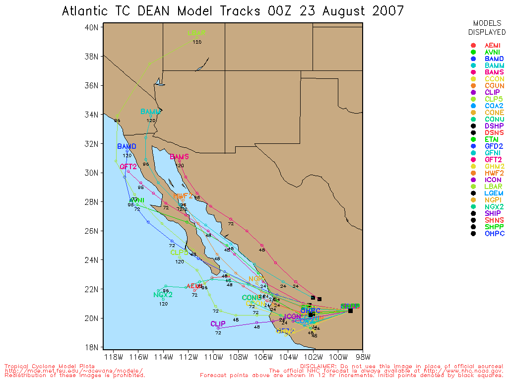
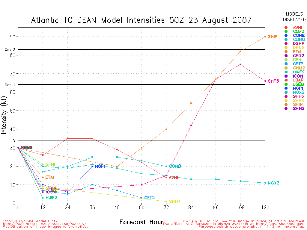
See: http://moe.met.fsu.edu/~acevans/models/al042007.png
|
Random Chaos
Weather Analyst
Reged: Sat
Posts: 1024
Loc: Maryland
|
|
The double eyewall is clearly visible on visible satellite. I have enhanced the visible satellite to make it move clear.
Original (NRL): Link
Greyscale Enhanced: http://www.vorklift.com/temp/dean_enhanced_double_eyewall.png
Color Enhanced: http://www.vorklift.com/temp/dean_colorenhanced_double_eyewall_visble.png
Recon recently found concentric eyewalls at 16 and 36 NMs.
Edit:
P.S. - is anyone else around today?
Edited by Random Chaos (Sun Aug 19 2007 02:06 PM)
|


 Threaded


