MikeC
Admin
Reged: Sun
Posts: 4543
Loc: Orlando, FL
|
|
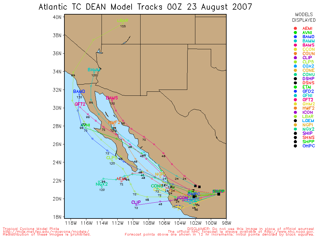
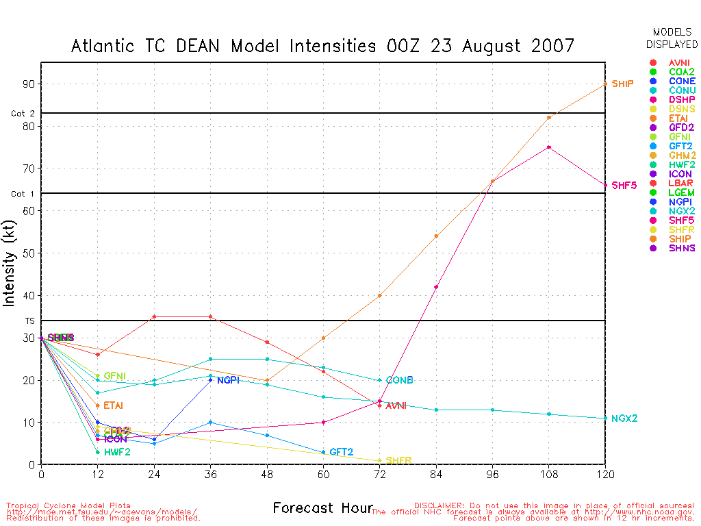
Dean seems to be reorganizing more as it nears the mainland coastline in Mexico, for it's second landfall, likely as a category 2 Hurricane. It should enter Central Mexico and then rapidly weaken over the Mountains of Central Mexico. Somewhere between Veracruz and Tuxpan..

The wave over the Bahamas is looking a little better this morning, but still moving too quick and unorganized to do much to Florida other than bring just a little rain to South Florida. It still is worth watching when the system gets into the Gulf.
Chances for Tropical Development of Wave Northeast of the Caribbean (92L) within the next 48 hours
Code:
(forget it) 0 1 2 3 4 5 6 7 8 9 10 (sure thing)

            [---*----------------]
Hurricane Dean Event Related Links


SFWMD Model Plot (Animated Model Plot) SFWMD Hurricane Page
[https://flhurricane.com/floatanimator.php?year=2007&storm=4 Flhurricane Satellite Floater Animation of Dean
GOES Floater
Animated Model Plot of Dean
Clark Evans Track Model Plot of Dean
(Animated!) Model Plots in Google Earth - In Google Maps
Clark Evans Intensity Model Plot of Dean (Animated!)
Clark Evans Track Plot of Dean
Other Model Charts from Clark
Clark Evans Top 10 Analog Storms for Dean
More model runs on from RAL/Jonathan Vigh's page
NRL Info on Dean -- RAMMB Info
COD Atlantic Satellite View
92L (Wave over Bahamas)) Event Related Links


SFWMD Model Plot (Animated Model Plot) SFWMD Hurricane Page
[https://flhurricane.com/floatanimator.php?year=2007&storm=6 Flhurricane Satellite Floater Animation of 92L
GOES Floater
Animated Model Plot of 92L
Clark Evans Track Model Plot of 92L
(Animated!) Model Plots in Google Earth - In Google Maps
Clark Evans Intensity Model Plot of 92L (Animated!)
Clark Evans Track Plot of 92L
Other Model Charts from Clark
Clark Evans Top 10 Analog Storms for 92L
More model runs on from RAL/Jonathan Vigh's page
NRL Info on 92L -- RAMMB Info
COD Atlantic Satellite View
|
allan
Weather Master

Reged: Thu
Posts: 468
Loc: Palm Coast, Florida
|
|
Dean looks like he wants to be a major storm again.. looking at the convection build up near the eye.. havn't seen that since he first became a Hurricane.. I mean the black looking convection on the IR satellite.. I give it a medium chance at becoming a major at landfall but the is right, the window of that happening is rapidly closing.. So I guess we'll see what happens, I doubt this will be a Pacific storm named Gil.
*haha guess I was wrong at it making landfall as a major as it appears Dean has made it's last and final landfall in Mexico just now as a Category 2 Hurricane*
--------------------
Allan Reed - 18,9,5
Edited by allan (Wed Aug 22 2007 11:20 AM)
|
Wxwatcher2
Storm Tracker

Reged: Tue
Posts: 337
Loc:
|
|
I've follwed Dean as the storm has formed and made its way to it's demise in Mexico.
I would like to thank all the METS and weather savvy folks who have post here during
tropical events.
While I can look at the data and draw my conclusions, it's nice to get everyones input
and see what thinking goes into the posted comments.
I find it very interesting, at least for me that the , while still a most worthy source
of "official" information, has become less and less porminant in the public's eye.
If you turn on the news, including CNN,FOX, NBC and others, you will note that they
all have their own METS who very very rarely if ever cut to the for a live shot as
was so common just a few short years ago. My, how things have changed in the
way we receive our hurricane news. I do see a lot of anchors on the news channels
making wrong statements about the storms. Their lack of understanding and knowlege
does show from time to time.
Anyway, bye bye Dean and I'm turning my eye Eastward to see what will come our way
around Labor Day.
|
MikeC
Admin
Reged: Sun
Posts: 4543
Loc: Orlando, FL
|
|
The did an amazingly good job with Dean, and pretty much stuck to the westerly forecast, and in this case it was a good call, in fact the has had a great record so far the past several years and this continues it.
The wave train off Africa looks pretty impressive right now, too.
|
allan
Weather Master
Reged: Thu
Posts: 468
Loc: Palm Coast, Florida
|
|
Yes, they did an incredible job with Dean, the track never even wobble much after Dean hit the carribean.. they should be honored.. in my opinion, this is the first storm they did an excellent job on since of 2005. Hopefully there good work will continue throught the year and beyond! 
--------------------
Allan Reed - 18,9,5
|
Ed G
Weather Hobbyist
Reged: Thu
Posts: 77
Loc: Clermont, Fl
|
|
Mike, would you please post a link to the African wave train you are speaking of?
thanx
|
cchsweatherman
Weather Watcher
Reged: Tue
Posts: 34
|
|
The were the most accurate they have ever been on forecasting a storm with Dean. There was near pin-point precision and accuracy in terms of the forecast track all the way for a one week period. They did an amazing job and I have to praise them for their undue diligence in getting this forecast track right on the money. In my opinion, the is better than and all local news stations combined in their conservative, yet aggressive style of forecasting which should give everyone prone to a landfall tropical system some peace in mind.
It does appear as if the wave train has been revived now, so it could be any day now when we have our next developing tropical system. The wave approaching Florida will provide some needed rainfall and maybe some gusty winds. Besides that, thank God the tropics are quiet. We don't need another Dean.
I just want to close my comment out by saying that I wish the best of luck to all those directly impacted by the fury of Hurricane Dean. Now they will need our help to recover. Please do what you can to assist not only those struck by Hurricane Dean, but the Peruvian Earthquake that killed thousands of undeserving people.
|
Addicted2Cane
Verified CFHC User
Reged: Thu
Posts: 13
Loc:
|
|
Quote:
Mike, would you please post a link to the African wave train you are speaking of?
thanx
Here's a link,
http://www.ssd.noaa.gov/PS/TROP/DATA/RT/eatl-ir4-loop.html
--------------------
Where is the wind and rain...I NEED to sleep!!
|
rammerjammer
Registered User
Reged: Wed
Posts: 1
|
|
Has anyone noticed 's satellite page has an invest back up on 92L?
|
LisaC
Weather Watcher
Reged: Wed
Posts: 39
|
|
I agree that the did a fab job with Dean. I was impressed how accurate the 5 day cones were.
|
Beaumont, TX
Storm Tracker
Reged: Tue
Posts: 318
|
|
Yes, I noticed. Does anyone think this could develop if it gets into the Gulf?
|
bigbelly
Registered User
Reged: Wed
Posts: 5
|
|
Quote:
Mike, would you please post a link to the African wave train you are speaking of?
thanx
Here is a link of the African wave train - http://www.ssd.noaa.gov/met8/eatl/loop-avn.html
|
Lee-Delray
Weather Master

Reged: Thu
Posts: 429
|
|
The African Wave rain is looking like the express???? I live in Florida, hope the Bermuda high goes to Greenland if any of these start cooking.
|
B_from_NC
Verified CFHC User
Reged: Wed
Posts: 23
Loc: Raleigh, NC
|
|
Quote:
Has anyone noticed 's satellite page has an invest back up on 92L?
Yes, but its interesting that they mention in the 2:00 discussion the low spinning just east of the Bahamas versus the one that I also see around 27.5N, 77.0W....
Anyone else see this????
--------------------
Lived in S. Fla from '90-'07...
Put up and took down way too many hurricane shutters!
|
Tak
Weather Watcher
Reged: Tue
Posts: 41
Loc: Altamonte Springs, FL
|
|
Lots of Saharan dust/dry air north of it too.
http://cimss.ssec.wisc.edu/tropic/real-time/wavetrak/winds/m8split.html
|
HanKFranK
User

Reged: Mon
Posts: 1841
Loc: Graniteville, SC
|
|
a couple more advisories on dean and that should be that. the 03z advisory ought to be the last. dean is most likely too weak for a pacific side reflection to have much of a chance.
away east the upper trough enhanced showers around a weak surface trough continue as 92L. the low level vortmax is now a tad east of eleuthra island in the bahamas, nudging west a tad slower than the upper features around it. there still doesn't seem to be enough low level convergence to force it in the face of the shear aloft. like the says, probably just an enhancement of showers... unless something dramatic happens.
nothing of note to the east of that. is active but nothing of note is on it. emerging wave looks ok but models are skittish with it. some globals show a cut off northeast of bermuda around the weekend into next week. that appears to have as much a chance as anything in the basin for the meanwhile, barring any major deviation from the model consensus.
nhc played the guidance split down the middle with dean into the caribbean, until it starting grouping tight on the left... in which case they went wholeheartedly with it. that was the right move. i kept thinking the upper evolution was too quick and that dean would snag a bit on the upper low ahead of it, but they stayed perfectly in tandem and the hurricane barely passed 20N during it's lifetime. there was climatological precedent for that turn of events. like always i'm a bit too ready to buy into the worse scenarios... dean was strong as hell but it didn't directly hit any place where there was a great deal to break.
HF 2151z22august
|
UKCloudgazer
Verified CFHC User

Reged: Wed
Posts: 21
Loc: Wallasey
|
|
Yes, I have been watching the little spinner at about 023N 051W. Nothing showing up on the experimental forecasts though.
|
LisaC
Weather Watcher
Reged: Wed
Posts: 39
|
|
Here in Ft. Lauderdale the local weather folks have been saying a tropical wave should be affecting us since yesterday. Well this is the best tropical ever because its sunny and breezy.
|
Random Chaos
Weather Analyst

Reged: Sat
Posts: 1024
Loc: Maryland
|
|
Thought everyone would find this interesting from the Pacific :
"A BROAD AREA OF DISTURBED WEATHER...ASSOCIATED WITH THE REMNANTS OF
ATLANTIC HURRICANE DEAN...IS LOCATED NEAR THE COAST OF MEXICO IN
THE VICINITY OF MANZANILLO. DEVELOPMENT...IF ANY IS EXPECTED TO BE
SLOW AS THE SYSTEM MOVES WESTWARD OR WEST-NORTHWESTWARD OVER THE
NEXT COUPLE OF DAYS.
IT SHOULD BE NOTED THAT IF THIS SYSTEM WERE TO REGENERATE INTO A
NAMED TROPICAL CYCLONE...IT WOULD NOT RETAIN THE NAME DEAN SINCE
DEAN DID NOT MAINTAIN ITS STATUS AS A TROPICAL CYCLONE OVER THE
MOUNTAINS OF MEXICO. "
|
h2ocean
Weather Hobbyist

Reged: Fri
Posts: 91
Loc: South Merritt Island, FL
|
|
Nice! The looks squashed tonight. Almost all convection decreased rapidly today. Hope this continues. There is a decent wave coming off Africa, but the last several have fallen apart.
--------------------
Merritt Island, FL Home Weather Station
|


 Threaded


