MikeC
Admin
Reged:
Posts: 4544
Loc: Orlando, FL
|
|
5:00 PM CDT 22 July Update
Dolly's internal structure has improved this afternoon. Recent IR and hi resolution visible imagery strongly argue for the production of an eye. We are also see the explosive genesis of a feature. This combined with recent reconnaissance report of 75kt flight level wind has prompted to upgrade Dolly to hurricane status.
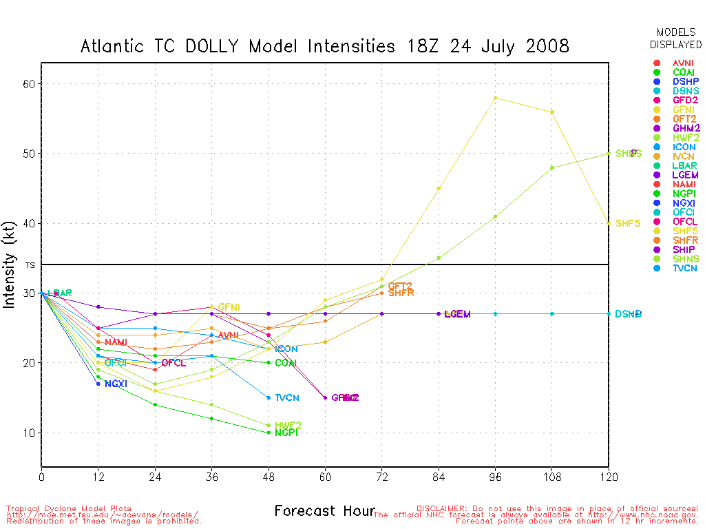
As of the 5pm update, her forward motion has been decreasing slightly and is now northwest at 10mph. Central pressure was ~ 986mb and her maximum winds were set at 75mph.
Oceanic heat content remains good, shear has relaxed considerable over what Dolly experienced with the yesterday, and upper level divergence is looking good with clear anticyclonic outflow established. There is just every so slightly some impinging southerly winds do to the s final last tentacles of contact, but it appears these are too weak at this point to be much of any significant mitigation to development. It is for these reasons that the official intensity by is set a little higher than the more robust model solutions, now taking Dolly to 80kts just prior to making landfall. It should be noted however, that a couple of higher resolution models (discussed below) are a tad slower and farther north along the coast. The longer Dolly stays over the warm waters of the Gulf, the stronger she may become.
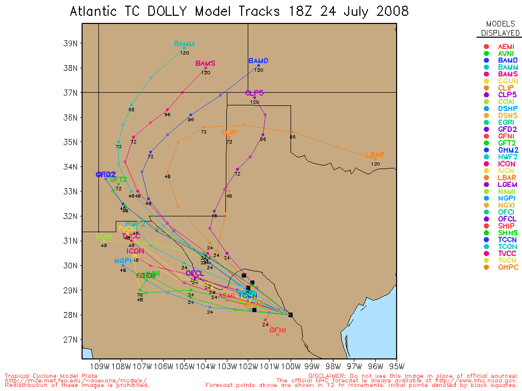
There is some contention during the afternoon on where/when Dolly will cross the coastline. Earlier runs had somewhat tightly clustered around an ~ Brownsville landing. However, a couple of the higher resolution models, including the WRF and the HWRF, are bringing Dolly up farther along the TX Coast before turning her left and on land. For this reason, folks up into the Bend area of the TX Coast need to monitor this with due diligence. This is also a good time to remind people not focus on the exact location the actual eye crosses the coast, and to pay close attention to the wind field radii information.
This is also going to be a slow mover as it comes in land. Citizens in the interior parts of southern TX and near the Rio Grande valley need to take early precautionary measure to protect against the threat of flooding for what is likely to be a protracted period of excessive rainfall while Dolly slowly winds down.
John (typhoon_tip)
11:00 AM EDT/10:00 AM CDT 22 July Update
Dolly remains a Tropical Storm for now the /Upper low is still holding it in and it will do so unless it escapes it entirely it will remain a Category 2 system or lower.
Hurricane Warnings were lowered to Tropical Storm Warnings north of Corpus Christi.
It will likely slowly strengthen today.
Links for Webcams, Radar, and news outlets in the area have been posted toward the bottom of this article, including 4 flhurricane recordings.
8:00 AM EDT/7:00 AM CDT 22 July Update
Dolly is finally starting to shake (but hasn't completely) the effect of the Upper Level Low (now over the western edge of the Bay of Campeche) and is starting to slow down as mentioned by prior National Hurricane Center forecasts. Indications are it will likely slowly gain strength throughout the day. Pressure is now 993 mb and windspeed is at 65MPH.
Dolly should become a hurricane later this morning and likely gain strength throughout the day. Since the outflow problems that it was having seem to be going away, it could undergo rapid intensification (This is very unpredictable... most likely it will not and stay Category 2 or lower) Folks in Northern Mexico and southern Texas (The Hurricane Warnings) should rush any more preparations today as conditions will start to deteriorate this evening.
10:55PM EDT/9:55PM CDT Update
The earlier hurricane watch area has now been upgraded to a Hurricane Warning. A tropical storm warning is up from Port O'Conor to San Luis pass, Also the Hurricane Warning enters Mexico to San Fernando.
The National Hurricane Center expects Dolly to become a hurricane but not a Major Hurricane. Likely a Category 1 at landfall, right at or just south of the Texas/Mexico border Wednesday morning (around 7 or 8 am CDT). Locations just to the north of the landfall point will likely see most of the worst weather.
6:55PM EDT/5:55PM CDT Update
New minimum lowest pressure from recon confirms strengthening, down to 998mb from 1004.
Take a guess at where Dolly will go and how strong, Let us know in the Forecast Lounge... (Click here to add your comment) orhere to see others
6:46PM EDT/5:46PM CDT Update
There are some signs now that Dolly has begun strengthening, a new Recon plane is on it's way and finding lower pressure already (before reaching the system), and it appears from the visible and IR satellite that a Central Dense Overcast (CDO) is forming near the Center of Dolly.

The mid level dry socket wrapping in from the east and south is starting to become filled in, setting the stage for possible strengthening this evening. If the new Central Convection holds it will likely build quickly.
5:00PM EDT/4:00PM CDT Update
There is not too much new to report, recon has still been struggling to find a true center, but has indeed found one. The movement is still west northwest at around 18MPH. Dolly is expected to start slowing down forward motion tomorrow morning.
The watches are still up and portions of them may enter into warnings later tonight or tomorrow morning.
Satellite presentation of Dolly is very mixed, currently the western edge seems to be fairly well defined, but the southeastern section has a very interesting dry section that follows along to a remnant of the in the Bay of Campeche. This is the only really negative thing going for it. The water temperatures, shear and anticyclone above it are all favorable for development. But with a lack of a really solid inner core, not too much can happen. If it does form, it could increase rapidly.
There is the potential for a rapid ramp up before landfall, which is why everyone in the watch area must start some preparations, and when hurricane warnings go into effect, execute them. Although the chances of a rapid intensity increase are only about 20%, it's still possible. Areas at and north of the eventual landfall point will likely see the worst of whatever Dolly brings. There is no good reason doubt the forecast track that the National Hurricane Center has put out.
Those in the watch/warning area need to listen to officials and local media, and as warnings approach, get off the Internet and do some preparations. Do the prudent thing here, although it is most likely that Dolly will not gain too much strength, the chance is high enough where you need to prepare for it or worse. Rule of thumb is to prepare for 1 category level above what is forecast.
2:00PM EDT/1:00PM CDT Update
Dolly is maintaining its windspeed direction and movement as of the 2PM EDT advisory according to recon.
The models have shifted a bit south, but still don't have the best handle on the system.
It appears the National Hurricane Center's forecast track will be good.
Hurricane Watches Up in Texas Brownsville to Port O'Connor, Tropical Storm watch from Port O'Connor to San Luis Pass.
Mexico has a hurricane watch from Rio San Fernando to the US/Mexico Border.

10:56AM EDT/9:56AM CDT Update
Hurricane Watches Up in Texas Brownsville to Port O'Connor, Tropical Storm watch from Port O'Connor to San Luis Pass.
Mexico has a hurricane watch from Rio San Fernando to the US/Mexico Border.
Looks like since the early AM, the surface low has indeed formed, the Hurricane Center is suggesting intensification, so those in the hurricane watch areas need to be beginning hurricane preparations. Do not focus on the landfall point, those (especially to the north) are forecast to possibly see hurricane condition within 36-48 hours.
There is a chance that the storm may slow its forward motion as it nears the coast.
More to come soon.
10:38AM EDT/9:38AM CDT Update
Recon just sent back a vortex message,
Center:
22° 04' N 89° 10' W (22.1°N 89.2°W)
Surface winds roughly 55MPH. This implies it is forming further north.
10AM EDT/9CDT Update
Recon yet again did not find a distinct low level circulation center, this probably means it is up for formation, best guestimate right now (which may change in a few minutes) may be a little to the east of where the main blob is now.
Also most of the convection is on the northern side of the system, so those to the north (right) of the landfall point will likely see the worst of whatever Dolly Brings.
Shear is nonexistant right now, water temperatures are warm, movement is fairly fast west northwest right now, however some slowdown and collapse of steering currents may happen late tomorrow.
Everyone in the cone of probability needs to be watching Dolly closely.
Original Update
Tropical Storm Cristobal is now moving away from the Carolinas and out to sea as a 50 MPH Tropical Storm. It brought some rainfall to the Carolina coast, but most of the heavy convection was over the ocean. Cristobal never made landfall on the US.
Tropical Storm Dolly is highly questionable this morning. This system has been very resistant to tropical development for a week now, and even as a named system it seems to be missing a low level circulation. And without a Low-Level Circulation the argument that it is not a Tropical Cyclone could be made. Convection wise, cloud tops are very cold, and the convection that is there is pretty strong.
Dolly's center position was readjusted to the north overnight and it is now re-emerging into the Gulf of Mexico, and now is moving generally west-northwest, which suggests the National Hurricane Center's track is still pretty good.
From analyzing it this morning, it seems the forecast track may have to be adjusted to the left (south, more into Mexico) if the current trend continues. The ridge to the north and the fact that it remains very weak and not so organized is suggesting that it will likely keep the more westerly track.

Northern Mexico probably has the best chance of seeing a landfall. Since the center may be more at the Mid-Levels (again a questionable tropical cyclone) it's very possible the system could reform its center again. Aircraft Recon is out checking out dolly now to help determine this.
What do you think Dolly will do? Let us know in the Forecast Lounge (Click here)
The lack of a good circulation center will keep the entire cone watching, from South Texas to Mexico (more likely Northern Mexico). Intensity wise, it's even harder to say. Following persistent trends suggest it may stay weak, but the Gulf of Mexico is known to change things.
Outside of this, an unusually vigorous wave is exiting the African coastline, and if it persists we'll have something else to track for a good while. More discussion on this wave can be found here

More to come later
Event Related Links
Cozumel Weather
Cancun Radar Cancun Radar Loop (Flhurricane long term recording)
Texas/South Plains Radar Composite
Southeast Radar Composite (loop)
Local Media:
Brownsville Herald
The Monitor
Valley Morning Star
KGBT 4 News
KRGV Newschannel 5
KURV 710 News/Talk
Webcams:
Coastal Surfing Pier Cam (Corpus Christi)
South Padre Island Cams: BeachCam SurfCam Bay Cam
Rio Grande Cam in Mission, TX
Matamoros/Brownsvillle Cams
Recordings:
Dolly Brownsville Level 3 Radar (Now Active)
South Padre Beach Cam
South Padre Island Surf Cam -- High Res (Not Active Yet)
South Padre Island Bay Cam (Now Active)
Edited by typhoon_tip (Tue Jul 22 2008 09:16 PM)
|
MikeC
Admin
Reged:
Posts: 4544
Loc: Orlando, FL
|
|
Since I got a few emails about this this morning.... Things may change pretty quickly with Dolly, so just wanted to put up a reminder to keep watch, especially through the afternoon. Although the westerly track is more likely, if Dolly does get organized and gains strength then northerly is definitely possible as well.
Dvorak T Numbers are around 3.0, so it is doing pretty well convection wise right now. If recon finds evidence of a Low Level Circulation then those numbers will be important.
Everyone in that forecast cone needs to be watching this system.
|
craigm
Storm Tracker

Reged:
Posts: 327
Loc: Palm City, Florida
|
|
Dolly is really moving. At this speed warnings will be up along the Texas/ Mexican coast within 24 hours unless she slows down. Notice I didn't say what flavor of warning.
--------------------
Why I'm here:
Weather hobbyist
|
MikeC
Admin
Reged:
Posts: 4544
Loc: Orlando, FL
|
|
Recon just sent back a vortex message,
Center:
22° 04' N 89° 10' W (22.1°N 89.2°W)
Surface winds roughly 55MPH. This implies it is forming further north.
|
cieldumort
Moderator

Reged:
Posts: 2305
Loc: Austin, Tx
|
|
A rough extrapolation of this fix suggests that indeed Dolly has hooked to a WNW course, once leaving the tip of the Yucatan, and having previously been on a NW course (smoothed out and accounting for center jumps). Extending this motion all the way out to landfall, extreme south Texas/ extreme NE Mexico does still appear to be the target... but only if one draws a pretty strait line, and Dolly then follows marching orders to the letter.
A strengthening Dolly might now be in order, but her continued on again off again connection to the surface, and rather oblong, loopy convective appearance on satellite, suggests s l o w strengthening, if any, in the near term. Even with some gradual improvement today, I do not perceive any reason to suspect much in the way of any possible deviation from the currently expected WNW track, baring any more center reformations, for the remainder of today.
|
typhoon_tip
Meteorologist
Reged:
Posts: 576
|
|
Quote:
Since I got a few emails about this this morning.... Things may change pretty quickly with Dolly, so just wanted to put up a reminder to keep watch, especially through the afternoon. Although the westerly track is more likely, if Dolly does get organized and gains strength then northerly is definitely possible as well.
Dvorak T Numbers are around 3.0, so it is doing pretty well convection wise right now. If recon finds evidence of a Low Level Circulation then those numbers will be important.
Everyone in that forecast cone needs to be watching this system.
Right now Dolly is being guided swiftly along by a ridge axis over the SE U.S. However, most global numerical models predict the influence of this large scale synoptic feature to wane enough to weaken the steering field substantially. This should induce a slowing of the forward speed beginning at ~ 60 hours.
It should be noted that in addition to slowing...a few of the overnight track guidance have shifted substantially north of the previous runs. The 06Z and HWRF, for example, take Dolly to over 90kts and bring her ashore in the TX Bend area...perhaps missing Mexico altogether in these solutions. While such details are far from certain, you do bring up a good point that might be a harbinger, relating to a stronger system having more polar-ward ascent. Overnight...as we noted by a number of posters and apparently confirmed, Dolly did a center jump, such that much of her circulation managed to stay over water...not encountering the deleterious effects of land. This asserts a stronger ramp up curve (potentially), but more importantly, most of the past guidance was based on a weaker system that passed more bodily over the Peninsula. Since that did not take place, the 12Z runs will be more telling.
There is a con and a pro at the moment, to faster intensification:
A broad circumavallate requires a longer duration to concentrate a core;
In about 1 day, Dolly will be moving headlong across a very rich oceanic heat content, where the thermocline extends quite deep...indicating more than the usual heat content (we saw what did when she passed over such feature in the eastern Gulf).
..Because the overall environment has recently gone from marginal/shear, to very little shear with an upper level anticyclone sprawling all the western Gulf, I'm going to go ahead assume the upper ends of the intensity spectrum will be achieved. Part of this decision is also based on tropical cyclones, once garnered enough momentum, tend to exceed guidance better than 50% of the time. Since (finally) a real central axis to the circulation is definable (hi res visible imagery), she's developing an inner core and it appear that threshold is nearing. I like the 's idea to go a bit aggressive, while perhaps conserving a little do to Dolly's large size.
Edited by typhoon_tip (Mon Jul 21 2008 05:03 PM)
|
danielw
Moderator

Reged:
Posts: 3525
Loc: Hattiesburg,MS (31.3N 89.3W)
|
|
I bit of a different view. Different color filters used here:

image courtesy of NOAA~danielw
|
typhoon_tip
Meteorologist
Reged:
Posts: 576
|
|
Nice image...
The IR channel at TPC is indicating a rather shredded looking Dolly this mid-day, though. Despite some of the discussion points being made by all...I am bemused to note there is still a presence near the lower BOC area, and this I think I'll have to admit is effecting Dolly still more than we and previously believed.
If you go here, http://www.ssd.noaa.gov/goes/flt/t2/loop-avn.html, and then click the wind overlays you can really detect that taking place. Hard to say what's in store for the next 24 hours, but this feature is supposed to be fully pulling away.
Edited by typhoon_tip (Mon Jul 21 2008 06:25 PM)
|
MikeC
Admin
Reged:
Posts: 4544
Loc: Orlando, FL
|
|
Quote:
Nice image...
The IR channel at TPC is indicating a rather shredded looking Dolly this mid-day, though. Despite some of the discussion points being made by all...I am bemused to note there is still a presence near the lower BOC area, and this I think I'll have to admit is effecting Dolly still more than we and previously believed.
If you go here, http://www.ssd.noaa.gov/goes/flt/t2/loop-avn.html, and then click the wind overlays you can really detect that taking place. Hard to say what's in store for the next 24 hours, but this feature is supposed to be fully pulling away.
I've been looking like crazy for the reason for Dolly not really getting itself together and that's about the best reason I've seen yet. Thanks for pointing that out. It has probably pushed the center reformations yet. I hope this sticks around as it will keep Dolly weaker.
|
Storm Hunter
Veteran Storm Chaser

Reged:
Posts: 1370
Loc: Panama City Beach, Fl.
|
|
AFRecon just went back threw Dolly.. pressure falling .. dwn 1mb to 1004mb
Observation Number: 08
A. Time of Center Fix: 21st day of the month at 19:01:00Z
B. Center Fix Coordinates: 22°46'N 90°43'W (22.77N 90.72W)
B. Center Fix Location: 143 miles (230 km) to the NNW (330°) from Mérida, Yucatán, México.
C. Minimum Height at Standard Level: Not Available
D. Estimated (by SFMR or visually) Maximum Surface Wind: 32kts (~ 36.8mph)
E. Location of the Estimated Maximum Surface Wind: 32 nautical miles (37 statute miles) to the ESE (107°) of center fix
F. Maximum Flight Level Wind Inbound: From 179° at 31kts (From the S at ~ 35.7mph)
G. Location of Maximum Flight Level Wind Inbound: 33 nautical miles (38 statute miles) to the ESE (108°) of center fix
H. Minimum Sea Level Pressure: 1004mb (29.65 inHg) - Extrapolated
I. Maximum Flight Level Temp & Pressure Altitude Outside Eye: 22°C (72°F) at a pressure alt. of 365m (1,198ft)
--------------------
www.Stormhunter7.com ***see my flight into Hurricane Ike ***
Wx Data: KFLPANAM23 / CW8771
2012== 23/10/9/5 sys/strms/hurr/majh
|
danielw
Moderator
Reged:
Posts: 3525
Loc: Hattiesburg,MS (31.3N 89.3W)
|
|
Checking back in I see that you've been dicussing what I thought I was seeing on the Dreamcicle loops.
Dolly appear to have a split personality. And an appearance somewhat like a crescent roll.

LLCC is to the western side of the CoC. But keep an eye on the NE Quadrant. That, at first glance, appears to have a mid level circulation.
By the way. The extreme outer circulation around Dolly is affecting the weather here, 65 miles inland. Winds from the East at 5 to 10 mph and all of the afternoon thundershowers are moving toward the West.
|
danielw
Moderator
Reged:
Posts: 3525
Loc: Hattiesburg,MS (31.3N 89.3W)
|
|
Recon is consistantly flying the 1000mb level or around 1000 ft abaove the surface. This is Normal for an INVEST but slightly abnormal for a Tropical Storm. They should be flying the 850mb or 700mb levels. 5000 and 10000 feet, respectively.
Obvious they are looking for an anomaly of some type... Dolly seems to fit the word, Anomaly, as a whole.
Water vapor sat photo supports the theory discussed above.

|
Storm Hunter
Veteran Storm Chaser
Reged:
Posts: 1370
Loc: Panama City Beach, Fl.
|
|
well... AF Recon is back home now, but NOAA Reg. Num. N43RF, Nickname "Miss Piggy" is about to arrive very shortly. Descending down through 8,000ft coming in from the NE side of Dolly.. I would suspect that they would heavy fly the SE side of the center... to get some lower to mid upper air data... which i think is a factor in why Dolly hasn't taken off with convection, YET...
**side note.. about 10 mins ago.. NOAA9 and NOAA3 passed each other by about 50-60miles... pretty sure the jet could of seen the P-3** looks like NOAA9 is almost done with its mission...
--------------------
www.Stormhunter7.com ***see my flight into Hurricane Ike ***
Wx Data: KFLPANAM23 / CW8771
2012== 23/10/9/5 sys/strms/hurr/majh
Edited by Storm Hunter (Mon Jul 21 2008 10:30 PM)
|
Storm Hunter
Veteran Storm Chaser
Reged:
Posts: 1370
Loc: Panama City Beach, Fl.
|
|
latest data from NOAA3... there almost to the center... and i would think that sense there staying at about 7,550ft.. on the inbound.. there mission is a little different, or they may see a closed center on radar on the plane... last check there about 20 miles from center of Dolly.. winds at flight level at 7,749ft... From 117° at 40 knots (From the ESE at ~ 46.0 mph... they should be hitting the convection soon.
see attached
--------------------
www.Stormhunter7.com ***see my flight into Hurricane Ike ***
Wx Data: KFLPANAM23 / CW8771
2012== 23/10/9/5 sys/strms/hurr/majh
Edited by Storm Hunter (Mon Jul 21 2008 10:50 PM)
|
MikeC
Admin
Reged:
Posts: 4544
Loc: Orlando, FL
|
|
Safe to say now that Dolly is over the hump and is now in strengthening mode, unfortunately for those in the Path. Again, if you are please make preparations now, as it could potentially strengthen quite a bit before landfall. 986 mb from some of the recon recently is one indication. I still would like to see a full Vortex message, however.
|
Storm Hunter
Veteran Storm Chaser
Reged:
Posts: 1370
Loc: Panama City Beach, Fl.
|
|
Vortex from center should be in shortly.. next few mins... dropsonde from about 60miles out came in about 10 mins ago... NOAA3 is well to the SW of center now... they flew through from NE to SW.
Flight LEVEL center was at:
Time:
22:38:00Z
Coordinates:
22.97N 91.63W
Acft. Static Air Press:
759.0 mb (~ 22.41 inHg)
Acft. Geopotential Hgt:
2,391 meters (~ 7,844 feet)
Extrap. SFC. Press:
998.6 mb (~ 29.49 inHg)
D-value:
-
Flt. Lvl. Wind (30s):
From 39° at 7 knots (From the NE at ~ 8.0 mph)
Air Temp:
14.5°C (~ 58.1°F)
Dew Pt:
14.5°C (~ 58.1°F)
Peak (10s) Flt. Lvl. Wind:
9 knots (~ 10.3 mph)
SFMR Peak (10s) SFC. Wind:
23 knots (~ 26.4 mph)
SFMR Rain Rate:
7 mm/hr (~ 0.28 in/hr)
**see close up attachment image
UPDATE: Just got a dropsonde.. but it was to the southwest of the CoC...
Edited by Storm Hunter (Mon Jul 21 2008 11:11 PM)
|
WeatherNut
Weather Master
Reged:
Posts: 412
Loc: Atlanta, GA
|
|
The last couple of frames are now showing an eye in the middle of the . Is there a recon in there now?
--------------------
Born into Cleo (64)...been stuck on em ever since
|
LoisCane
Veteran Storm Chaser

Reged:
Posts: 1236
Loc: South Florida
|
|
not sure but there are enough eyes in the sky on her
she seems to have an affinity for intensifying just prior to the 11pm and then we have to wait up with her to see what she is doing
she is slowing it seems and if she does... she will intensify, as much as she is an anomaly she works on basic science.. sitting over warm water should spark up her convection around the center seriously over the next few hours or later tonight
keep watching
--------------------
http://hurricaneharbor.blogspot.com/
|
WeatherNut
Weather Master
Reged:
Posts: 412
Loc: Atlanta, GA
|
|
They got a pressure reading of 985 23.20N 92.40W.
I dont think they are near the center yet either
--------------------
Born into Cleo (64)...been stuck on em ever since
|
cieldumort
Moderator
Reged:
Posts: 2305
Loc: Austin, Tx
|
|
This is a little bit of an eye-opener. Might be one bad read, but then again, with an apparent eye formation now underway, maybe not. It may just take the winds a few more hours to really catch up.
Time, Location and Flight Level:
02:22:00Z 23.20N 92.40W 766.5 mb, 2,305 meters (flight level pressure, flight level)
Pressure:
Extrap: 985.0 mb (~ 29.09 inHg)
Peak 10-second Flight-level winds:
78 knots (~ 89.7 mph)
|


 Threaded


