Ed Dunham
Former Meteorologist & CFHC Forum Moderator (Ed Passed Away on May 14, 2017)
Reged: Sun
Posts: 2565
Loc: Melbourne, FL
|
|
Update - Sunday, 08/03 Noon ET
The Low pressure area in the Gulf of Mexico may form into a depression or storm later today or tomorrow and all those along the central gulf into Texas will want to watch this.
More to come soon.
Update - Friday, 08/01 5PM ET
Invest 99L in the central tropical Atlantic with a weak circulation center near 17.5N 38.5W at 01/21Z moving westward with little convection. Windshear should limit any chance for development until Monday.
Active but disorganized tropical wave passing through the Windward Islands into the eastern Caribbean Sea over the weekend. Convection is present, but this system will encounter west to westnorthwest wind shear over the next couple of days. A small chance for some development after the weekend as the shear relaxes.
Another wave is located south southwest of the Cape Verde Islands near 12.5N 26W at 01/18Z moving westward under light easterly shear. SSTs are about 26C and this system may have the best chance for eventual development. Note that convection is currently displaced to the southeast of the wave apex. At 02/12Z, has designated this wave as Invest 90L located at 11.5N 27.7W. Conditions remain favorable for slow development of this system.
Finally, another active wave is located over west Africa near 14N 5W at 01/18Z.
Lots of things to watch, but nothing to cause any concern for the moment.
ED
Update - Wednesday, 07/30 12AM ET
Invest 98L just off the west African coast near 14N 18W at 30/00Z moving slowly westward in a narrow zone of light wind shear. SSTs of about 26C. Surface low pressure center of 1008MB. Slow development is possible over the next few days.
Second wave near 9N 37W at 30/00Z also moving slowly westward. Wave has a small area of convection but is currently not as well organized as Invest 98L.
ED
Original Post
For the first time this month, the Atlantic Basin is relatively quiet. Invest 97L near 19N 44W at 26/00Z is disorganized and has quite a bit of drier air to contend with for the next 36 hours as it travels westward at 15 knots. Conditions will improve on Sunday and slow development is still possible later on Sunday or Monday.
A healthy tropical wave moved off the west African coast a couple of days ago but it quickly became disorganized under cool SSTs and strong easterly shear. It is entering a slightly more favorable environment but additional development is questionable. Note that easterly shear still exists off the west African coast westward to about 30W between 8N and 18N. The wave was roughly located at 9N 26W at 26/00Z.
Finally, an active and well organized tropical low exists over the African continent at 10N 2E at 26/00Z and this system will exit the coast in a few days.
ED
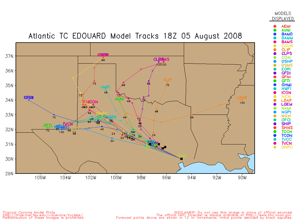
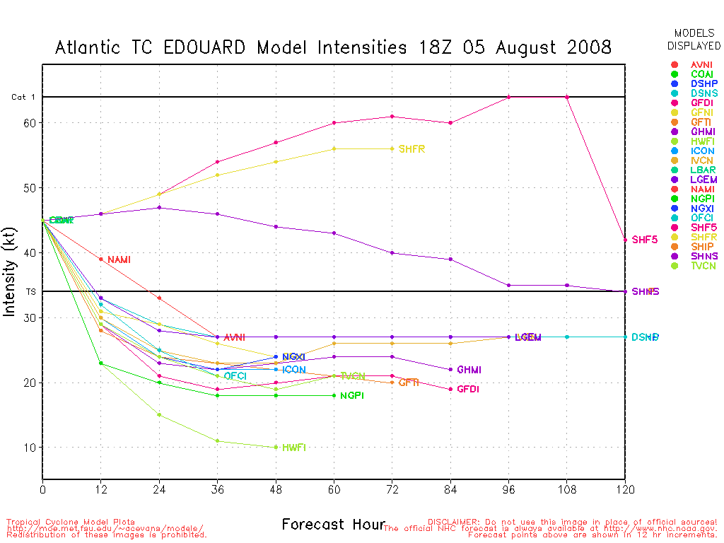
91L Event Related Links


SFWMD Model Plot (Animated Model Plot) SFWMD Hurricane Page
[https://flhurricane.com/floatanimator.php?year=2008&storm=5 Flhurricane Satellite Floater Animation of 91L
GOES Floater
Animated Model Plot of 91L
Clark Evans Track Model Plot of 91L
(Animated!) Model Plots in Google Earth - In Google Maps
Clark Evans Intensity Model Plot of 91L (Animated!)
Clark Evans Track Plot of 91L
Other Model Charts from Clark
Clark Evans Top 10 Analog Storms for 91L
More model runs on from RAL/Jonathan Vigh's page
NRL Info on 91L -- RAMMB Info
COD Atlantic Satellite View
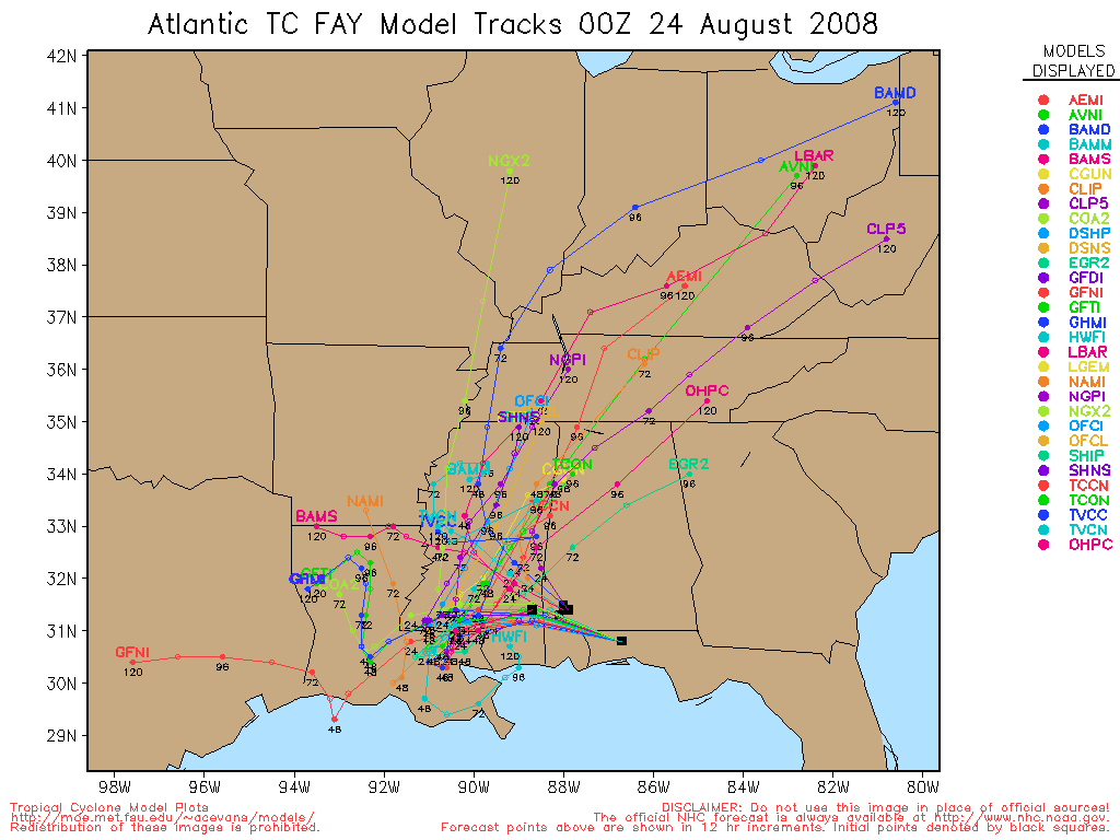
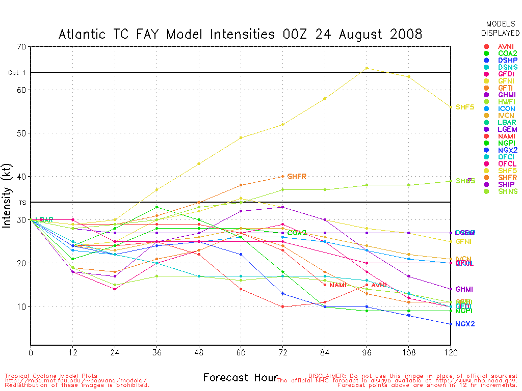
99L Event Related Links


SFWMD Model Plot (Animated Model Plot) SFWMD Hurricane Page
[https://flhurricane.com/floatanimator.php?year=2008&storm=6 Flhurricane Satellite Floater Animation of 99L
GOES Floater
Animated Model Plot of 99L
Clark Evans Track Model Plot of 99L
(Animated!) Model Plots in Google Earth - In Google Maps
Clark Evans Intensity Model Plot of 99L (Animated!)
Clark Evans Track Plot of 99L
Other Model Charts from Clark
Clark Evans Top 10 Analog Storms for 99L
More model runs on from RAL/Jonathan Vigh's page
NRL Info on 99L -- RAMMB Info
COD Atlantic Satellite View
Edited by Ed Dunham (Sun Aug 03 2008 12:25 PM)
|
Hurricane29
Weather Guru

Reged: Mon
Posts: 148
Loc: Miami Florida
|
|
Enjoy the slow period as the atlantic might spark back up into the 2-3 week of august as another strong pulse of the moves back into the atlantic just as we embark the meat of the season.
Flitered OLR Forcast....

|
craigm
Storm Tracker

Reged: Wed
Posts: 327
Loc: Palm City, Florida
|
|
H29, I was just studying up on the when I read your post. Couldn't agree with you more. Our active period are phases 1,2,7 & 8. You can see by this graphic that our increased activity in July correlates nicely with the data.
http://www.bom.gov.au/bmrc/clfor/cfstaff/matw/maproom/RMM/phase.Last40days.gif
Here are a couple more links that I have found quite interesting:
http://www.apsru.gov.au/mjo/explore.asp
http://www-das.uwyo.edu/~geerts/cwx/notes/chap12/mjo.html
--------------------
Why I'm here:
Weather hobbyist
|
LoisCane
Veteran Storm Chaser

Reged: Fri
Posts: 1236
Loc: South Florida
|
|
This really will be a good opportunity to watch and see and record if the season pulses up in accordance with the .
There was a tremendous amount of SAL that ate into 97. The next wave was low and is there but still low.
Waiting for the next big wave to come off to see or am wondering if some home grown brew or whatever that phrase is might happen.. a lot of wicked weather today across the coastal regions and all that rain will go where? Anything possibly could develop close in I wonder. Probably not but something to think on while watching waves.
--------------------
http://hurricaneharbor.blogspot.com/
|
LoisCane
Veteran Storm Chaser
Reged: Fri
Posts: 1236
Loc: South Florida
|
|
Check out the wave flaring up by south america. Interesting on a few loops. Maybe something to watch? Close to where Bertha played.
--------------------
http://hurricaneharbor.blogspot.com/
|
scottsvb
Weather Master
Reged: Mon
Posts: 1184
Loc: fl
|
|
I'm alittle interested in the Gulf system... it has no real model support...put it does have a weak area of low pressure.
scottsvb
|
danielw
Moderator

Reged: Wed
Posts: 3525
Loc: Hattiesburg,MS (31.3N 89.3W)
|
|
Appears to have a low to mid level circulation centered 120 to 180nm Southwest of Eglin AFB, FL radar.
Drifting west toward the Mouth of the Mississippi River.
http://vortex.plymouth.edu/gen_lnids.cgi?pl=n0z&cu=1&loop=yes1&ident=EVX
|
danielw
Moderator
Reged: Wed
Posts: 3525
Loc: Hattiesburg,MS (31.3N 89.3W)
|
|
AREA FORECAST DISCUSSION...UPDATED
NATIONAL WEATHER SERVICE NEW ORLEANS LA
1128 AM CDT MON JUL 28 2008
MEANWHILE...AN MCS IS UNDERWAY IN
THE COASTAL AND OFFSHORE WATERS WELL BELOW MOBILE BAY AND
ADVANCING WESTWARD. THIS MAY SERVE MORE IN DISRUPTING THE ONSET OF
GULF AND LAKE BREEZE AS WELL AS DISRUPTING INFLOW TO LAND BASED
CONVECTION ONCE ESTABLISHED. PRESSURES APPEAR TO BE HOLDING AROUND
1012MB WITH THIS CLUSTER BUT PERSISTENCE MAY SEE PRESSURES
STARTING TO FALL LATER. WILL CONTINUE TO MONITOR.
AFD LIX Full Text
edit- this could get very interesting rather quickly~danielw
|
scottsvb
Weather Master
Reged: Mon
Posts: 1184
Loc: fl
|
|
sophia your seeing a ULL near Cuba...the low south of Mobile is more in the LLV...but the east wind is very shallow on the N side of the low....lowest pressure I found is 1011.1mb.. It may not develop more..but its the only active area west of 60W thats worth looking at for me.
|
cieldumort
Moderator

Reged: Mon
Posts: 2305
Loc: Austin, Tx
|
|
This area of disturbed weather in the north-central GOM did get highlighted in the 2PM :
Quote:
SHOWER AND THUNDERSTORM ACTIVITY IN THE NORTHERN GULF OF MEXICO IS
ASSOCIATED WITH A WEAK SURFACE TROUGH OF LOW PRESSURE. NO
SIGNIFICANT DEVELOPMENT OF THIS SYSTEM IS EXPECTED AS THE TROUGH
MOVES SLOWLY NORTHWESTWARD.
I don't know.. I really have to say, while movement of the parent trough overall might be extending northwestward with time, the MLC, which seems to be holding its own very well for having been born from an MCS, looks to be drifting more west-southwestward, and dragging most of the umph of the associated surface trough along with it.
Typically, MCS-to-TC genesis is one of the less frequent ways depressions form in the Atlantic basin, as a whole, but is climatologically somewhat more possible in the Gulf. And in addition to that historical backdrop, this MCS is riding a frontolyzing zone of horizontal wind shear, or along the remains of a decaying front.
Here's where I want to say, "But wait! That's not all!" The disturbance also has a favorably weak ULL positioned just to its west, and such that there is also some divergence going on, but without imparting especially high shear. If anything, shear has been relaxing over this area throughout the day.
While has highlighted the feature with its yellow code ("LOW" probability of formation within 48 hours), I might venture a guess that it is on the high side of their "LOW" probability, and, especially given how close it is to land, should certainly be monitored closely for any signs of further development.
|
WeatherNut
Weather Master
Reged: Wed
Posts: 412
Loc: Atlanta, GA
|
|
I have also seen quite a bit of new convection bubbling up with this feature. If its still there tomorrow, its definitely something to watch since it has some outflow (or what looks like outflow) over it
--------------------
Born into Cleo (64)...been stuck on em ever since
|
Ed in Va
Weather Master
Reged: Fri
Posts: 489
Loc:
|
|
Pretty close to land, but big blow-up in the GOM system this morning:
http://www.ssd.noaa.gov/goes/east/gmex/loop-vis.html
--------------------
Survived Carol and Edna '54 in Maine. Guess this kind of dates me!
|
cieldumort
Moderator
Reged: Mon
Posts: 2305
Loc: Austin, Tx
|
|
Situation with the NGOM feature this morning doesn't offer much excitement. Late last night, convection went out like a candle, but started flaring back up by 3 or 4am CDT, and now, once again, has grown back into a respectable MCS. However, unlike yesterday, the surface trough has become less well-defined. Cloud motions in the lowest levels almost all head generally northward, with only a slight bend noted, where just yesterday there existed definitive cyclonic flow near and at even at the surface. Area surface pressures are not falling and winds are generally light.
Of note, a low to mid-level swirl, probably the remnant vorticity signature from Monday's blow-up, is located near 27N 89W this morning. Over the last few visible frames it appears to be tucking under some of the deeper offshore convection... there remains a slight chance, however slim, that this could make some connection with the surface that actually sticks, later today.
Almost all forecasts are now calling for the disturbance to move northwestward to northward, bringing rains and thunderstorms to much of Louisiana, and perhaps then looping back to the northeast to east, enhancing the precipitation over the southeast and/or Florida.
The tropical waves that have been rolling off Africa and make it beyond the cooler SSTs of the eastern Atlantic the past several days have been choking on some very dry air/SAL and just hang on for dear life - if not bite the dust - even the most impressive of them.
This latest wave centered near 11.5N 17W looks to have some good vorticity in the mid-levels, and is not yet plagued by SAL.
|
M.A.
Weather Guru
Reged: Thu
Posts: 108
Loc: Vero Beach, Fl
|
|
My eyes are drawn to around 9N 34W. Is this the defunked 97L? It seems to be making a strong comeback, if it is. Looking at the sat loop it has deminished in storm coverage in the last few frames. Earlier it was seeming to have some outflow on the southern side. I think it needs to be watched in the coming days as conditions seem to be improving.
|
cieldumort
Moderator
Reged: Mon
Posts: 2305
Loc: Austin, Tx
|
|
This was starting to look overdue, so it's good to see that 98L is now up.
Some of us have been eyeballing this one very closely for a few days now.
They really don't come rolling right off the tip of Africa much better than this:

|
ltpat228
Storm Tracker

Reged: Tue
Posts: 201
Loc: Port Saint Lucie FL
|
|
NAVY site has this posted now:
http://www.nrlmry.navy.mil/tc-bin/tc_hom...p&TYPE=ssmi
|
cieldumort
Moderator
Reged: Mon
Posts: 2305
Loc: Austin, Tx
|
|
It's pretty clear tonight that 98L has been developing at a good clip, so far
- and to no surprise, already yanking northbound.
Lacking any ship or buoy reports, the nearest stations are land-based. Pressures a good bit easterly of 98's coc have already been down to 1007mb, with sustained winds from the southwest, south, southeast, east-southeast and southeast in a range of 10-25mph... (Inland, and a jump east of the center.)
Combined with the latest estimates, it's easy to argue that an upgrade could be on the way this morning, should convection stay healthy. Here are the latest from SAB, which some may think the most recent two look a little conservative:
30/0600 UTC 14.4N 18.8W T1.5/1.5 98L -- Atlantic Ocean
30/0000 UTC 13.4N 17.6W T1.0/1.0 98L -- Atlantic Ocean
30/0000 UTC 13.4N 17.6W TOO WEAK INVEST -- Atlantic Ocean
29/1730 UTC 12.2N 16.9W TOO WEAK INVEST -- Atlantic Ocean
29/1200 UTC 11.3N 16.6W TOO WEAK INVEST -- Atlantic Ocean
98L has been on a solid NNW course -
to be expected of a more developed feature.
Early model support for 98L is almost flat. So far, they all are starting with a weaker feature than has existed. Thinking a few more microwave passes, and hopefully a solid scat or two, everything else being equal, especially convective-wise, daylight may very well seal the deal for , and perhaps then we should be able to start getting some model runs on it worth considering. Given the rapid ramp-up and NNWD track so far, it might be only one for the CVs to worry about. Regardless, lots and lots of blue between there and over here...
Waiting for daylight...
|
danielw
Moderator
Reged: Wed
Posts: 3525
Loc: Hattiesburg,MS (31.3N 89.3W)
|
|
Navy shot of 98L approximately 90 minutes ago.
BIG fish spinner. Big system and Big fish.
Better hope that this one follows Bertha's course.

|
cieldumort
Moderator
Reged: Mon
Posts: 2305
Loc: Austin, Tx
|
|
It's had a lot going for it, and plenty of Internet observers have already come to the conclusion that it could have been classified early this morning. . QuikSCAT came in.. a little elongated, but not really all that much, and appears to have sufficiently paired surface and mid-level cocs. Sure, the waters are a little cooler where it is -now- now that it has already gone bonkers and headed a lot north of where it was progged, and so over the past few hours cloud tops have warmed. But structurally it is pretty sound. There might be a bit of umbilical connection with the they would like to see completely severed, but this is not unlike several of the depressions we have seen form in the extreme eastern pacific this season.
SAB is running a little slow with publishing their T reads, but here's the latest from about 8AM EDT
30/1145 UTC 15.1N 19.9W T1.5/1.5 98L
Track looks as if it has been turning at least a little more northwesterly, than north-northwesterly now. If you only read the s, you would think it's been much of nothing and heading west to northwest. I don't get this, at all. However, 98L is now bumping up against the B/A High some more... and might start to hook a little more left as the day goes on... certainly could still put the CVs in its sights, although it's already looking possible that it bypasses them completely to the north.. maybe even rounds them from the north.
Here's a very striking recent water vapor image also courtesy .

Edited by Ed Dunham (Thu Jul 31 2008 12:51 AM)
|
metwannabe
Weather Hobbyist

Reged: Wed
Posts: 92
Loc: NC
|
|
Storms in western Caribbean near coast of Nicaragua and Honduras are persisting. This area appears to be drifting northward. And there appears to be some slight circulation, most likely in the mid or upper levels. But pressures are falling in that area, could be something of note. Any thoughts?
--------------------
Fran, Bertha, Dennis & Floyd (Tag Team)
|


 Threaded


