MikeC
Admin
Reged:
Posts: 4544
Loc: Orlando, FL
|
|
11PM EDT Independence Day Update
Invest 95L located at 27.7N 90.3W at 05/00Z. As quickly as the system seemed to spin up this afternoon, it has spun down this evening. still says a 20% chance for tropical cyclone development in the next couple of days, but those chances are probably on the decline. System is drifting west at 5mph with very limited convection.
Invest 96L has multiple centers between Grand Caymen Island and northeast Honduras at 05/00Z and has a 50/50 chance for additional development in the next couple of days. The system has slowed down and seems to be moving generally to the northwest at 10mph into a zone of light but increasing north windshear. Although buoys/ships have reported winds close to TS strength, the wave still appears to be an open system.
A third active wave east of the Islands near 14.5N 59.5W at 05/00Z has developed additional convection and could become an area of interest in a few days. Thunderstorms observed at Barbados earlier today - the Windward Islands can expect showers and gusty easterly winds on Monday.
An area of earlier convective development in the Bahamas has quieted down this evening. The area is quasi-stationary and its future development chances are low.
ED
5:30PM EDT 4 July 2010 Update
95L in the Gulf suddenly has spun up quite a bit this afternoon, and has a chance to become a depression/storm. If so it would be a very small system, similar to Marco in 2008.
Many are "out of pocket" today, so we'll update as soon as possible.
8:25AM EDT 4 July 2010 Update
The low in the Gulf looks like it will be history today, as it was never expected to develop.

However the wave in the western Caribbean (96L) has a much better overall chance to develop, and could in the next few days. If it were to form it would most likely take the westerly track and wind up in Mexico. The situation is slightly different than with Alex, so it'll require monitoring by those in the Gulf through the week.
8:35PM EDT 3 July 2010 Update

Nothing much as changed during the day regarding the two areas. The area in the western Caribbean is not being tracked as an invest at this time. The area in the Gulf is being tracked as an invest (95L) because of proximity to US land, but is still not expected to develop.
9AM Update
The low in the Gulf is on its way to dissipating, and likely will not develop. IT has less than !0% chance to, and dropping.
This leaves a good tropical free weekend for those in the Atlantic Basin, last next week it may change, but for now ifor those in the US, enjoy the independence and holiday.
The areas to watch for later in the week are a wave in the Central Atlantic, and a disturbance in the Western Caribbean.
Original Update
Hurricane Alex was a large hurricane, and caused a great deal of flooding rains, but for South Texas it was far south enough to only have minimal surge. In Mexico, things were much worse, but it also made landfall in a mostly unpopulated area.
What comes after Alex? It's likely to be a quiet weekend for development, but there are things to watch, especially after that, and a lot of rain in the Northeastern Gulf.
The Gulf has too much northerly shear right now and has a low chance for anything to form in it in the short term. There is an area of lower pressure that is the remnants of a mid latitude system. Since it is close to land and is worth watching to see if conditions change.
There is however, tons of moisture in the Gulf will cause a lot of extra rainfall in the southeast either way. There is a low chance (10%) of development here. It would take a while for anything to transition to tropical here.
This system is being tracked as Invest area 95L.
Most likely the system in the Gulf will not develop.
Another viable potential wave right now is one in the Central Atlantic (near 40W), but that probably won't even get a shot at development until it gets much closer to the Caribbean.
Models are picking up something in the West Caribbean for early next week as well.
Those in Texas/Mexico will have to deal with the Flooding Rains. Otherwise, for those in the US, enjoy independence weekend, but keep watching the tropics.
|
Fairhopian
Weather Watcher
Reged:
Posts: 26
Loc:
|
|
Mike, were you speaking to the 10% potential for development in the Big Bend area when you said the northerly shear would prevent it? Also, can someone describe the convective feature south of the Bay of Pigs? I have seen no official mention of it and can see no low level winds associated with it, but it has that cyclonic look, as well as a lot of moisture to work with.
|
MikeC
Admin
Reged:
Posts: 4544
Loc: Orlando, FL
|
|
Was referring to the Northeastern Gulf area (the 10% area). The shear is quite noticeable on the water vapor imagery.
I'm changing around the main page a bit now that I'm looking a bit closer at things.
|
MikeC
Admin
Reged:
Posts: 4544
Loc: Orlando, FL
|
|
As far as the West Caribbean:
From Houston:
The Nam/Gfs/Ecmwf Are All Working A
Tropical Wave into a Tizzy in the Western Caribbean on Monday
Unfortunately the Same Upper Ridging Should Be Flattening And
Shifting East Opening Up the Western Gulf to This Wave/Tropical
System. Interestingly the 00Z Looks Like the 18Z Which
Has It Nearing the Texas Coast Friday the 9th. It is Still To
Early to Hang a Hat on This Solution but Should Still Point to The
Possibility of Something of Interest in the Western Gulf. Rain
Chances Should Be Coming Down Monday and Tuesday as Moisture Thins
And Upper Ridging Creeps Southward.
|
MikeC
Admin
Reged:
Posts: 4544
Loc: Orlando, FL
|
|
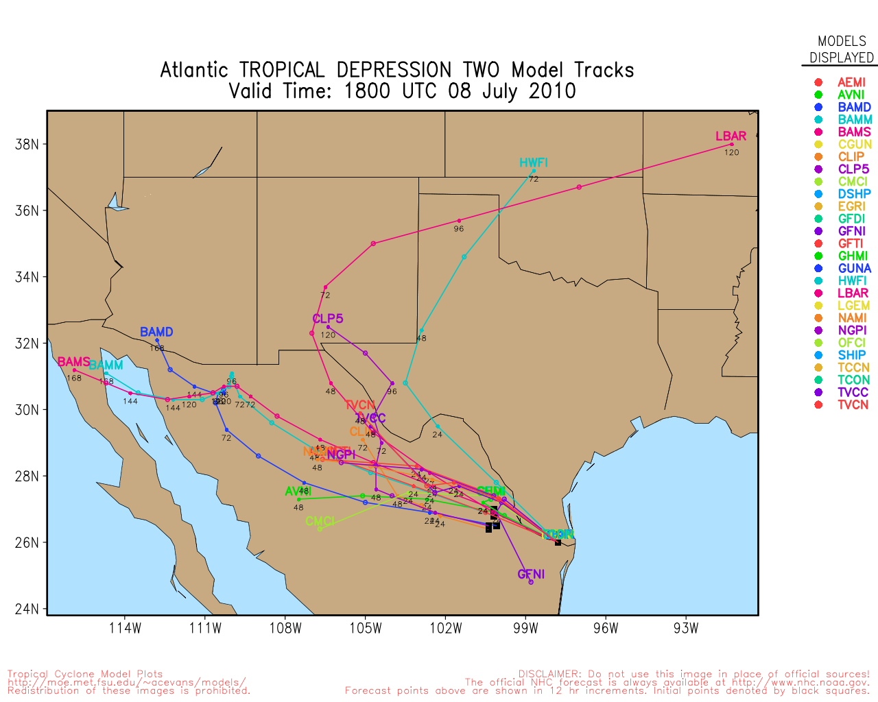
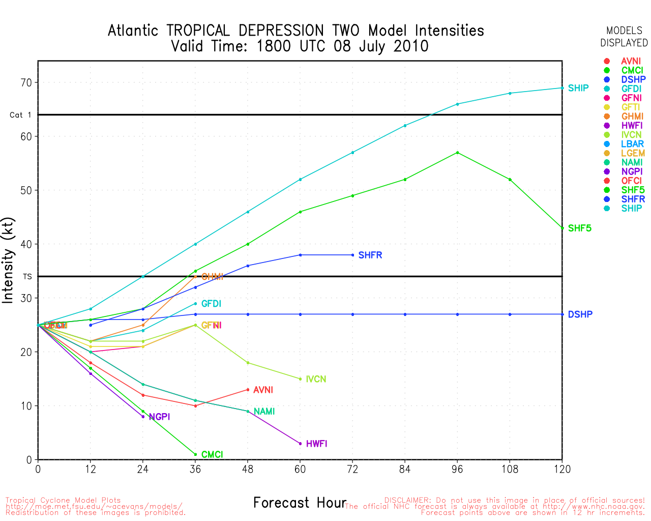
Invest 95L is the area in the northeast Gulf.
|
Lamar-Plant City
Storm Tracker

Reged:
Posts: 383
Loc: Plant City, Florida
|
|
Had anyone here looked at that Tampa Radar loop this morning. Lots of precipitation moving in a generally circular pattern over this area. There seem to be lines of storms that spin out of the GOM every so often. There was one approaching Pinellas County last night when I went to bed and another one was evident this morning. It is still basically visible stretching west and northwest of Tampa? Are these features due to that upper low that spun our way the past couple of days?? Wet day here anyways.
--------------------
If you don't like the weather, wait 5 minutes...
2023 Season Prediction: 17/6/2
|
Fairhopian
Weather Watcher
Reged:
Posts: 26
Loc:
|
|
Quote:
Was referring to the Northeastern Gulf area (the 10% area). The shear is quite noticeable on the water vapor imagery.
Looking at the last few Visible frames, there are a couple of westward moving vortices in this area. While the most predominant one appears to be over land, it is about to emerge over the warm, oil slick waters south of Panama City. While the WV shows no moisture, local radar does show some, so the air is not exactly or completely dry.
Since it's so close to my backyard, my eyes are fixed on the area south of PC for the next few hours as the atmosphere warms and the front shifts back and forth, though the shear may still keep that non-tropical low reduced to a ghost.
|
danielw
Moderator

Reged:
Posts: 3525
Loc: Hattiesburg,MS (31.3N 89.3W)
|
|
WEATHER RECONNAISSANCE FLIGHTS
CARCAH, National Hurricane Center, MIAMI, FL.
1000 AM EDT FRI 02 JULY 2010
SUBJECT: TROPICAL CYCLONE PLAN OF THE DAY (TCPOD)
VALID 03/1100Z TO 04/1100Z JULY 2010
TCPOD NUMBER.....10-032
I. ATLANTIC REQUIREMENTS
1. SUSPECT AREA (GULF COAST)
FLIGHT ONE - TEAL 70
A. 03/1800Z
B. AFXXX 01BBA INVEST
C. 03/1700Z
D. 28.5N 86.5W
E. 03/1730Z TO 03/2130Z
F. SFC TO 10,000 FT
FLIGHT - TEAL 71
A. 04/0600Z
B. AFXXX 0202A CYCLONE
C. 04/0445Z
D. 28.0N 87.0W
E. 04/0515Z TO 04/0930Z
F. SFC TO 10,000 FT
2. SUCCEEDING DAY OUTLOOK: BEGIN 6-HRLY FIXES
AT 04/1800Z IF SYSTEM DEVELOPS.
Pardon the remark. That oil doesn't seem to be having a whole lot of effect on the weather. Looks like it's the other way around. The weather is messing up the oil recovery efforts.
Edited by danielw (Fri Jul 02 2010 04:36 PM)
|
stormtiger
Weather Hobbyist
Reged:
Posts: 73
Loc: Baton Rouge, La.
|
|
Looking at water vapor loops, it appears the area where 95L is being plotted is immediately to the East of the big upper level high that allowed Alex to "breathe", and just south of a mid summer cold front that has a ton of dry air behind it. Upper level winds are not conducive to development.
There's another big ULL East of the Bahamas and another in the west central Carribean.
In the near term I can't see any tropical development in the traditional July breeding grounds.
Way too much shear.
|
berrywr
Weather Analyst

Reged:
Posts: 387
Loc: Opelika, AL
|
|
The first question everybody is likely to be asking is whether this surface low pressure center that is developing on or near the stationary front in the GOM is tropical; the answer is NO. This doesn't imply that at some future date it may become tropical; however it is unlikely and here are the reasons why:
1. UW-CIMMS analysis this morning has winds from the N and NNW at 20 knots and higher to the west.
2. Eastern USA longwave trough continues to dig (as depicted via water vapor satellite imagery) into the NE GOM and analysis of the 500 millibar upper air analysis reveals the trough extending across FL to a cutoff upper low at 29N 84W.
3. Over the past several days weight has been given more towards the and it's run to run performance than the which while consistent has been overly aggressive with this feature.
4. There's no doubt there's a low; however it is in my opinion it is baroclinic and not tropical at this time. Given the upper air environment and the amount of time it would take for this system to transform from baroclinic to tropical; highly unlikely.
5. I see nothing to suggest a hybrid storm at this time however there is one fly in the ointment; next week models invert an upper trough along the SE coast.
6. One interesting feature is along the . There is a tropical wave along 10N and 45W moving west and short of another disturbance south of Cuba; they are the only notable features today that have light shear above them; however for anything to develop there; shear must remain light directly over these systems; the surrounding environment is hostile.
Last but not least; Happy July 4th weekend to one and all and a reminder to keep residents of the Gulf coast in your hopes and prayers as the oil spill continues. I doubt there is a better sandwich than a Shrimp Po Boy and a cold, cold beer...okay two, fresh raw oysters, Ritz Crackers, hot sauce and cold, cold beer!
--------------------
Sincerely,
Bill Berry
"Survived Trigonometry and Calculus I"
Edited by berrywr (Fri Jul 02 2010 04:19 PM)
|
berrywr
Weather Analyst
Reged:
Posts: 387
Loc: Opelika, AL
|
|
There is an upper low in the NE GOM that explains why the precip is rotating counter clock; I hope that helps! Take care...Sincerely, Bill B.
--------------------
Sincerely,
Bill Berry
"Survived Trigonometry and Calculus I"
|
doug
Weather Analyst
Reged:
Posts: 1006
Loc: parrish,fl
|
|
I agree on the little low now south of St. Marks, FL. Lots of upper level wind shear here.
My eyes are drawn to the southern and western Carribean, in addition to the NEGOM. The brings another feature up out of this area and into the WGOM next week. The flare up exiting N'Wrd off from South America looks impressive. There already is a cyclonic twist to the cloud mass south of Cuba, probably in association with an upper low.
Still plenty left over from last week in this area to play with. Conditions more favorable in this region to support development.
--------------------
doug
|
danielw
Moderator
Reged:
Posts: 3525
Loc: Hattiesburg,MS (31.3N 89.3W)
|
|
Plenty to watch for the weekend. RECON will fly around Noon on Saturday to investigate what's to come for the rest of the weekend.
""Last but not least; Happy July 4th weekend to one and all and a reminder to keep residents of the Gulf coast in your hopes and prayers as the oil spill continues. I doubt there is a better sandwich than a Shrimp Po Boy and a cold, cold beer...okay two, fresh raw oysters, Ritz Crackers, hot sauce and cold, cold beer!""
Barq's root beer works great too!
|
hogrunr
Weather Guru

Reged:
Posts: 153
Loc: Spring, TX
|
|
12z , , and continue to develop the wave that is exiting north off of South America. Landfall is currently at the end of the long range forecast, so many things can change between now and then, but I really hope this is not true. 1st because it is showing to come on shore in almost the exact same location as Alex, but even if this is not the case, just the general area would create even more flooding disasters than there currently are. Even being in Houston, we continue to get the onshore flow ever since Alex moved through and there is plenty of flooding in the area. 2nd I hope this doesn't happen because I have vacation on the Texas coast (Rockport) starting next Friday (168 hours away)
|
MikeC
Admin
Reged:
Posts: 4544
Loc: Orlando, FL
|
|
There are recon missions planned for this system tomorrow, they may be canceled if nothing happens with 95L. If any development occurs, it probably won't be purely tropical.
Recon won't have far to travel in any case.
|
Storm Hunter
Veteran Storm Chaser

Reged:
Posts: 1370
Loc: Panama City Beach, Fl.
|
|
95L hmm.... getting beat by the dry air aloft and the shear... but hanging in there! Lots lightning in the red area and to the north...
--------------------
www.Stormhunter7.com ***see my flight into Hurricane Ike ***
Wx Data: KFLPANAM23 / CW8771
2012== 23/10/9/5 sys/strms/hurr/majh
Edited by Storm Hunter (Fri Jul 02 2010 09:26 PM)
|
berrywr
Weather Analyst
Reged:
Posts: 387
Loc: Opelika, AL
|
|
I've been looking at the Wind Shear analysis this evening...there's one remote shot that 95L might have to be taken seriously. There is an area of wind shear less than 10 knots that begins over South FL and extends southward through Cuba into the extreme western Caribbean and has been migrating northward. Winds over 95L are currently between 15 and 20 knots from the north. Now the bad news...wind shear rises dramatically from east to west becoming 30 knots near Mobile Bay, 40 knots over the MS River delta and LA and 50 knots near Houston, all from the north. I don't want everybody to get alarmed if recon runs a mission into the area for research. I grant you it's a pretty looking image on satellite and it will tests some nerves. I still believe the is handling this system and that is a weak non-tropical low moving southwest and west in response to the upper ridge to it's north.
--------------------
Sincerely,
Bill Berry
"Survived Trigonometry and Calculus I"
|
WesnWylie
Weather Guru
Reged:
Posts: 155
Loc:
|
|
I don't think 95L will have much of a chance in the NE Gulf because
it has taken in too much dry air. The strong shear in place over it continues
to tear any convection apart pretty quickly. The only chance I think it may
have is if it can work its way more toward the southwest than west. The area
that looks better today than yesterday is south of Jamaica since there has
been a nice blow up of convection there. It is in a pretty favorable area for
development with warm waters and low shear.
Any thoughts on the Western Caribbean wave today, anyone?
P.S. Here's a link to some REALLY good satellite imagery that is updated more
frequently than others: http://weather.cod.edu/analysis/satrad.regional.html
--------------------
2011 Season Forecast: 16/09/04
2011 Systems: 10/01/01
|
WesnWylie
Weather Guru
Reged:
Posts: 155
Loc:
|
|
95L appears to be trying to organize even though it is still
in a pretty hostile environment. The has upped its chance
of developing from 10% to 20%. The keeps saying that if
it develops it could have subtropical characteristics. I was
wondering why that is because aren't subtropical systems
typically associated with cool water? Whatever the case may be,
we don't need any more flooding rain in Texas-Alex was enough:(.
Also, could someone tell me what the website is that you guys
use when you post the progress of the RECON flights? Thanks.
--------------------
2011 Season Forecast: 16/09/04
2011 Systems: 10/01/01
|
WeatherNut
Weather Master
Reged:
Posts: 412
Loc: Atlanta, GA
|
|
The wave in the Western Caribbean has some pretty impressive convection firing tonight and it looks to be right under an ULH which is providing good outflow. I think this one is the one more likely to be a headache this week
--------------------
Born into Cleo (64)...been stuck on em ever since
|


 Threaded


