MichaelA
Weather Analyst

Reged:
Posts: 944
Loc: Pinellas Park, FL
|
|
Thanks, but I know all of that from being a Meteorology major once upon a time. 
--------------------
Michael
PWS
|
Storm Hunter
Veteran Storm Chaser

Reged:
Posts: 1370
Loc: Panama City Beach, Fl.
|
|
Recon hit some stronger winds due west of Dry Tortugas National Park... seen even possible TS winds in a rain band that were at the surface on the SMFR (roughly 75 miles west of the park).... seems the system is on the verge of a Sub-Tropical/Tropical Depression... the western side of the COC is not well defined, but it appears to be getting better with time.
--------------------
www.Stormhunter7.com ***see my flight into Hurricane Ike ***
Wx Data: KFLPANAM23 / CW8771
2012== 23/10/9/5 sys/strms/hurr/majh
Edited by Storm Hunter (Tue Aug 10 2010 08:53 PM)
|
MichaelA
Weather Analyst
Reged:
Posts: 944
Loc: Pinellas Park, FL
|
|
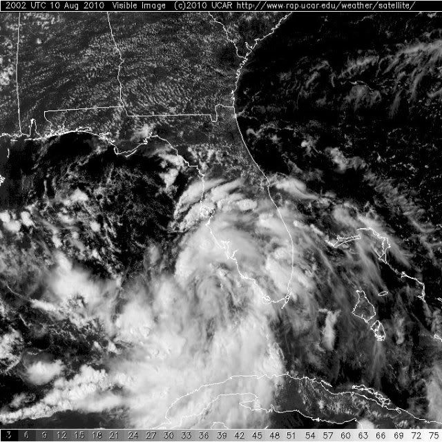
Key West radar is beginning to look rather impressive and may be indicating that some convection may be trying to redevelop near the center. This certainly looks like a developing system on both radar and vis sat pics. Also, it looks like the ULL over North FL is now enhancing the outflow NE of the system's apparent center. Heavy tropical style downpours moving through Pinellas County now.
http://www.srh.noaa.gov/ridge/radar.php?product=N0Z&rid=BYX&loop=yes
--------------------
Michael
PWS
|
Storm Hunter
Veteran Storm Chaser
Reged:
Posts: 1370
Loc: Panama City Beach, Fl.
|
|
not sure if yall saw this from NAVY...
WTNT01 KNGU 101400
MSGID/GENADMIN/NAVMARFCSTCEN NORFOLK VA//
SUBJ/TROPICAL CYCLONE FORMATION ALERT 101400Z AUG 10//
RMKS/1. FORMATION OF A TROPICAL CYCLONE IS POSSIBLE WITHIN 100NM
EITHER SIDE OF A LINE FROM 25.5N 83.0W TO 27.6N 87.2W OVER THE
NEXT 24 HOURS. AVAILABLE DATA DOES NOT JUSTIFY ISSUANCE OF A NUMBERED
TROPICAL CYCLONE WARNING AT THIS TIME.
2. A 0315 ZULU ASCAT PASS NORTHWEST OF THE FLORIDA KEYS
SHOWS AN AREA OF CLOSED CYCLONIC CIRCULATION WITH AN ASSOCIATED
TROUGH EXTENDING ALONG 25N 86W TO 27N 89W. CURRENT REGIONAL
MODELS ARE SHOWING SLIGHT INTENSIFICATION OF THIS LOW OVER THE
NEXT 24HRS. CURRENTLY THE LOW IS RESIDING UNDER 5 TO 10 KNOTS
OF NORTHERLY SHEAR. THIS IS IN CONJUNCTION WITH WARM SEA SURFACE
TEMPERATURES OF 85 TO 88 DEGREES FARENHEIT SHOULD HELP TO
ENHANCE THE DEVELOPMENT OF THIS TROPICAL FEATURE.
3. THIS ALERT WILL BE REISSUED, UPGRADED TO A WARNING OR ALLOWED TO
EXPIRE BY 111400Z AUG 2010.//
--------------------
www.Stormhunter7.com ***see my flight into Hurricane Ike ***
Wx Data: KFLPANAM23 / CW8771
2012== 23/10/9/5 sys/strms/hurr/majh
|
Lamar-Plant City
Storm Tracker

Reged:
Posts: 383
Loc: Plant City, Florida
|
|
Quote:
Key West radar is beginning to look rather impressive and may be indicating that some convection may be trying to redevelop near the center. This certainly looks like a developing system on both radar and vis sat pics. Also, it looks like the ULL over North FL is now enhancing the outflow NE of the system's apparent center. Heavy tropical style downpours moving through Pinellas County now.
http://www.srh.noaa.gov/ridge/radar.php?product=N0Z&rid=BYX&loop=yes
We had a heck of a squally band move over USF (north Tampa) about an hour ago. Lots of wind, rain and thunder. Moved out just as quickly, but more is developing to the south and east. They are taking on the distinct look of spiral bands as they develop. SOMETHING is cranking up to our south. Sure FEELS tropical outside (you have to have lived in Florida a long time to get away with that type of feeling).
--------------------
If you don't like the weather, wait 5 minutes...
2023 Season Prediction: 17/6/2
|
Storm Hunter
Veteran Storm Chaser
Reged:
Posts: 1370
Loc: Panama City Beach, Fl.
|
|
seems to me that the ULL is almost due north (NE GOM) now of the surface coc which appears that a anticyclonic setup appears will be setting up over 94L... feeling more and more that tonight the system will take better shape and prolly be upgraded to a TD, if not a TS at the 11pm adv. with watches and warnings for the coast of LA... basically Mobile, Al to just west of Grand Isle, La....
--------------------
www.Stormhunter7.com ***see my flight into Hurricane Ike ***
Wx Data: KFLPANAM23 / CW8771
2012== 23/10/9/5 sys/strms/hurr/majh
|
Storm Hunter
Veteran Storm Chaser
Reged:
Posts: 1370
Loc: Panama City Beach, Fl.
|
|
Recon Image on wunderground found 35mph surface winds... but that was well away from center from the data i am seeing..

--------------------
www.Stormhunter7.com ***see my flight into Hurricane Ike ***
Wx Data: KFLPANAM23 / CW8771
2012== 23/10/9/5 sys/strms/hurr/majh
|
MichaelA
Weather Analyst
Reged:
Posts: 944
Loc: Pinellas Park, FL
|
|
Quote:
Sure FEELS tropical outside (you have to have lived in Florida a long time to get away with that type of feeling).
Life long FL native here. I know the feel and feeling well and this one certainly has that "feel" to it. The ULL has moved into the Gulf just SW of Cedar Key and continues westward at a fairly good clip. 94L still looks to be drifting due North to me, though. Needs to be closely watched during the overnight hours.
--------------------
Michael
PWS
|
MichaelA
Weather Analyst
Reged:
Posts: 944
Loc: Pinellas Park, FL
|
|
That makes sense since any significant convection is removed from the apparent CoC for now. Waiting to see if that changes in the short term this evening or early tomorrow.
--------------------
Michael
PWS
|
WeatherNut
Weather Master
Reged:
Posts: 412
Loc: Atlanta, GA
|
|
Checking recon observations during this flight dew points have been rising and the continuing convection is really looking 'warm core'. The ULL is not on top of this system nor does it look like it will be. I think this is in the final phase of transition to purely tropical as it does not have have many 'subtropical' characteristics to account for creation of new convection. Also, it is over very warm water at great depths. I hope recon makes another pass south to see if DPs are indeed still rising
--------------------
Born into Cleo (64)...been stuck on em ever since
|
Storm Hunter
Veteran Storm Chaser
Reged:
Posts: 1370
Loc: Panama City Beach, Fl.
|
|
were are you seeing rise in Dew Points? so far too me it seems the last two hours the dewpoints along flight path have been around 50F at 1kft... and Recon is now on NW side of COC... still 50F dw point with air temps in the upper 70Fs
--------------------
www.Stormhunter7.com ***see my flight into Hurricane Ike ***
Wx Data: KFLPANAM23 / CW8771
2012== 23/10/9/5 sys/strms/hurr/majh
|
Storm Hunter
Veteran Storm Chaser
Reged:
Posts: 1370
Loc: Panama City Beach, Fl.
|
|
Recon just did a second pass on what i think is COC... doesn't appear tropical... gonna need some convection to become tropical? Center did go west... very slowly from last fix/pass
Time: 20:46:30Z
Coordinates: 25.8333N 84.15W
Acft. Static Air Press: 976.0 mb (~ 28.82 inHg)
Acft. Geopotential Hgt: 281 meters (~ 922 feet)
Extrap. SFC. Press: 1007.9 mb (~ 29.76 inHg)
D-value: -
Flt. Lvl. Wind (30s): From 196° at 2 knots (From the SSW at ~ 2.3 mph)
Air Temp: 25.1°C (~ 77.2°F)
Dew Pt: 9.0°C (~ 48.2°F)
Peak (10s) Flt. Lvl. Wind: 5 knots (~ 5.8 mph)
SFMR Peak (10s) SFC. Wind: 2 knots* (~ 2.3 mph*)
SFMR Rain Rate: 4 mm/hr* (~ 0.16 in/hr*)
(*) Denotes suspect data
--------------------
www.Stormhunter7.com ***see my flight into Hurricane Ike ***
Wx Data: KFLPANAM23 / CW8771
2012== 23/10/9/5 sys/strms/hurr/majh
Edited by Storm Hunter (Tue Aug 10 2010 08:57 PM)
|
WesnWylie
Weather Guru
Reged:
Posts: 155
Loc:
|
|
I have a feeling that if/when 94L becomes classified, it may be of a subtropical nature-at least in the short term.
Update: I think I see what looks to be an "eye-like" feature emerging in 94L. It appears to be moving westerly.: http://aviationweather.gov/adds/satellit...g&itype=vis
Edited by WesnWylie (Tue Aug 10 2010 09:12 PM)
|
WeatherNut
Weather Master
Reged:
Posts: 412
Loc: Atlanta, GA
|
|
My bad...didn't see the difference in altitude...oops
--------------------
Born into Cleo (64)...been stuck on em ever since
|
berrywr
Weather Analyst

Reged:
Posts: 387
Loc: Opelika, AL
|
|
According to HDOBS from recon... dew points are extremely low and also note the lack of convection and precipitation on the NW, W side of the system. The envelope of circulation is large. ASCAT pass at 2101Z shows a solid trough extending west to west-northwest of the CoC; what is either a decaying stationary front or surface trough. The wind field is fairly unifom all the way around. Upper low is about to exit FL near the Big Bend area continues to support the surface low. I continue to believe were looking at a subtropical system for the near term.
--------------------
Sincerely,
Bill Berry
"Survived Trigonometry and Calculus I"
Edited by berrywr (Tue Aug 10 2010 09:46 PM)
|
MikeC
Admin
Reged:
Posts: 4544
Loc: Orlando, FL
|
|
It doesn't look like an upgrade will happen today, tomorrow is the best shot, maybe earlier if warning pressure is put on them, but it still has quite a ways to go to develop, it's got a center of circulation, so it's just a matter of time. The upper low is keeping it on the weak side. If there is a big convective blow up they may upgrade it tonight, and convection needs to be better aligned/stacked.
Odds are still in favor it'll be a Tropical/Subtropical Storm heading into Louisiana.
Tutt's and upper level lows have been a big hamper this year in development so far.
The Setup makes it highly likely won't see any major hurricanes until next month.
|
MichaelA
Weather Analyst
Reged:
Posts: 944
Loc: Pinellas Park, FL
|
|
Looking at the latest Floater Vis Loop, there appear to be several low level vortices within the broad area of circulation. Still no deep convection anywhere near the apparent center, though, and the Key West long range radar loop presentation is more ragged in appearance.
--------------------
Michael
PWS
|
Storm Hunter
Veteran Storm Chaser
Reged:
Posts: 1370
Loc: Panama City Beach, Fl.
|
|
appears they may have pulled the plug?
ftp://ftp.tpc.ncep.noaa.gov/atcf/tcweb/invest_RENUMBER_al942010_al052010.ren
--------------------
www.Stormhunter7.com ***see my flight into Hurricane Ike ***
Wx Data: KFLPANAM23 / CW8771
2012== 23/10/9/5 sys/strms/hurr/majh
|
MikeC
Admin
Reged:
Posts: 4544
Loc: Orlando, FL
|
|
Pulling the plug? Appears so, may due to needing some watches/warnings up for the coast. They may put up a special advisory at 8, if not, by 11 .
|
MichaelA
Weather Analyst
Reged:
Posts: 944
Loc: Pinellas Park, FL
|
|
I wonder if they will classify it as tropical or sub-tropical. Doesn't look entirely tropical to me just yet.
--------------------
Michael
PWS
|


 Threaded


