MikeC
Admin
Reged: Sun
Posts: 4543
Loc: Orlando, FL
|
|
Update - 11PM EDT Saturday, 28 August 2010
Hurricane Danielle now located over 350 miles east of Bermuda and accelerating to the northeast at 20mph with sustained winds of 90 knots. Danielle should continue to head northeast and slowly weaken - becoming in about three days.
At 11PM EDT Tropical Storm Earl was located just over 500 miles east of the northern Leeward Islands with sustained winds of 55 knots and movement to the west at 17 knots. The following Watches/Warnings are now in effect:
A HURRICANE WARNING IS IN EFFECT FOR...
* ANTIGUA...BARBUDA...MONTSERRAT...ST. KITTS...NEVIS...ANGUILLA...AND SAINT MARTIN AND SAINT BARTHELEMY
A HURRICANE WATCH IS IN EFFECT FOR...
* ST. MAARTEN...SABA...ST. EUSTATIUS
* BRITISH VIRGIN ISLANDS
* U.S. VIRGIN ISLANDS
* PUERTO RICO INCLUDING THE ISLANDS OF CULEBRA AND VIEQUES
A TROPICAL STORM WARNING IS IN EFFECT FOR...
* ST. MAARTEN...SABA...ST. EUSTATIUS
Hurricane conditions are expected over the northern Leeward Islands by Sunday night and these conditions might spread to the Virgin Islands and Puerto Rico on Monday and Monday night. Storm surge of one to three feet is possible in the northernmost Leeward Islands since Earl is expected to strengthen to a hurricane with 85 to 90 knot sustained winds. Rainfall amounts of 3 to 5 inches with isolated amounts in the mountains up to 8 inches. Residents in the northern Leewards and the Virgin Islands should prepare for high winds and heavy rain squalls. Residents in Puerto Rico should closely monitor the progress of Earl and be prepared to initiate hurricane plans should the track of Earl move more to the south.
NHC forecasts Earl to pass northeast of Puerto Rico on Tuesday as a Category III major hurricane moving off to the northwest.
Invest 97L is still expected to develop - but it hasn't changed much today. Convection has become a little better organized and the circulation envelope is still quite large. The system is moving rapidly westward at about 22 knots. At 29/00Z the system was located southwest of the Cape Verde Islands at 12.7N 31.9W. Models present various solutions for this system (or none at all like the 18Z ), but it seems likely to develop - and we'll have plenty of time to monitor it during the upcoming week.
ED
5PM EDT Saturday, 28 August 2010 update
Tropical Storm Earl seems to be holding its own, even at brisk pace of 23MPH, it is still expected to become a hurricane over the next few days as it nears the Leeward islands in the Caribbean, some of which have tropical storm watches up. Odds still are it will recurve before the east coast of the US, but it could get close enough to cause very rough surf along the east coast this coming week. Those in the cone will want to watch the system very closely.
Those in the Leeward islands and in the cone of uncertaintly will want to watch this system closely,

Daniellie has weakened a bit since yesterday, but continues to move out to sea.
97L has not formed into a depression yet, but probably will so before the weekend is up. This system has the potential to track further west than any of the other systems from the Cape Verde so far, and will be worth watching at the end of next week and beyond. If this were to impact any ares, it would be around sept 5/6.
StormCarib Reports from the Caribbean Islands
Caribbean Weather Observations
Barbados Brohav Weather Fax
Full Caribbean Radar Composite
Caribbean Broadcast Corporation (TV/Radio from Antilles)
San Juan, PR NWS Page
Various Caribbean Radio Stations
DR1 Dominican Republic Hurricanes
St. Maarten Webcam
Danielle Event Related Links


SFWMD Model Plot (Animated Model Plot) SFWMD Hurricane Page
[https://flhurricane.com/floatanimator.php?year=2010&storm=6 Flhurricane Satellite Floater Animation of Danielle
GOES Floater
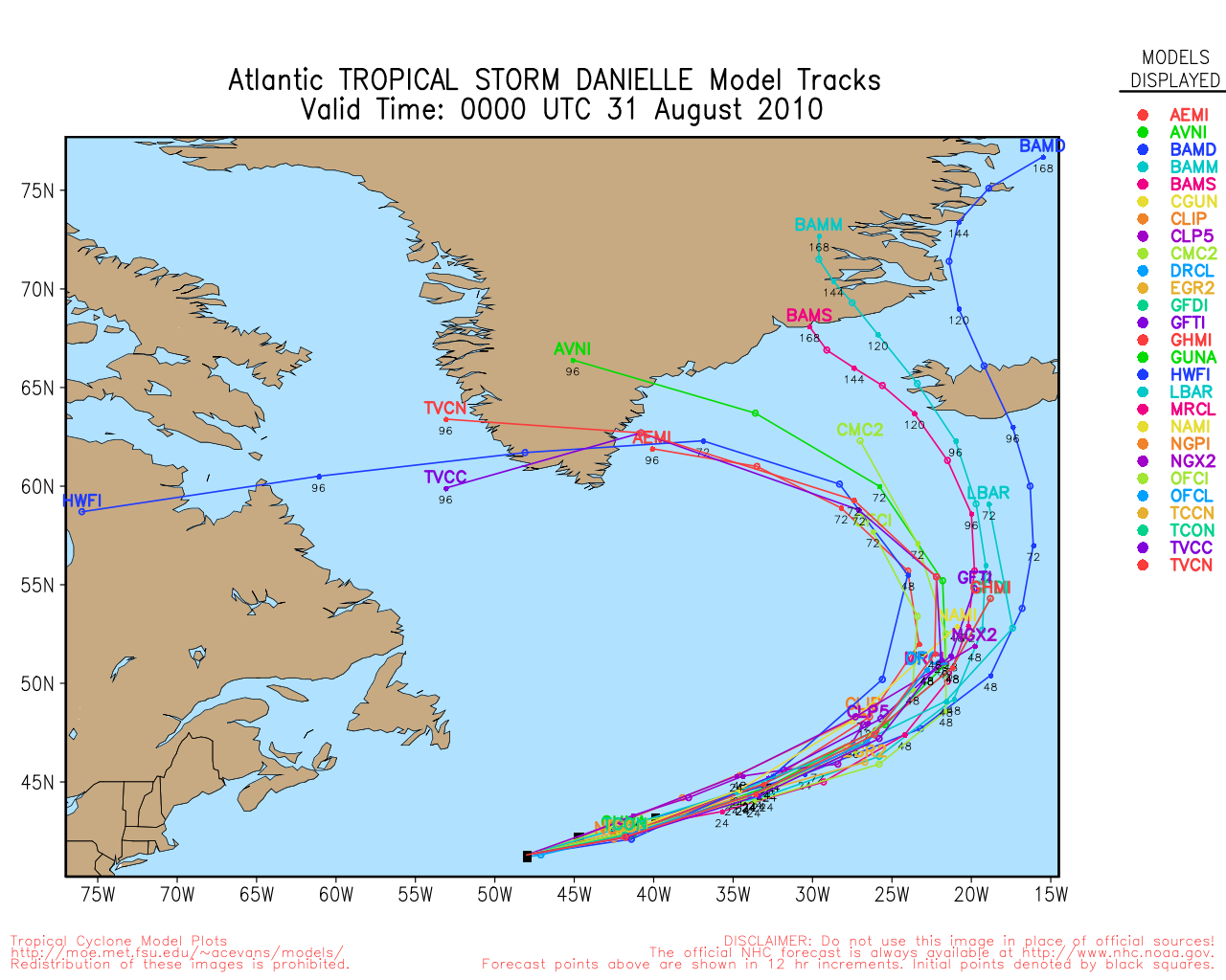
Animated Model Plot of Danielle
Clark Evans Track Model Plot of Danielle
(Animated!) Model Plots in Google Earth - In Google Maps
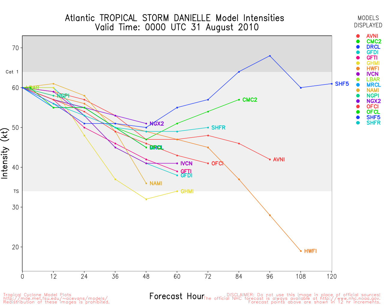
Clark Evans Intensity Model Plot of Danielle (Animated!)
Clark Evans Track Plot of Danielle
Other Model Charts from Clark
Clark Evans Top 10 Analog Storms for Danielle
More model runs on from RAL/Jonathan Vigh's page
NRL Info on Danielle -- RAMMB Info
COD Atlantic Satellite View
Earl Event Related Links


SFWMD Model Plot (Animated Model Plot) SFWMD Hurricane Page
[https://flhurricane.com/floatanimator.php?year=2010&storm=7 Flhurricane Satellite Floater Animation of Earl
GOES Floater
Animated Model Plot of Earl
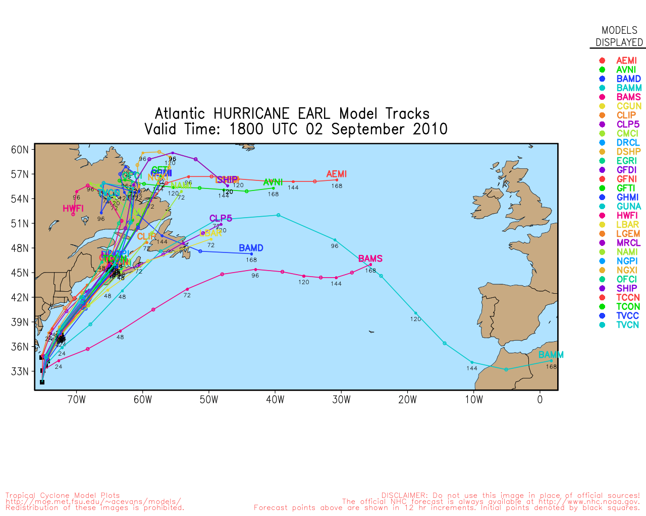
Clark Evans Track Model Plot of Earl
(Animated!) Model Plots in Google Earth - In Google Maps
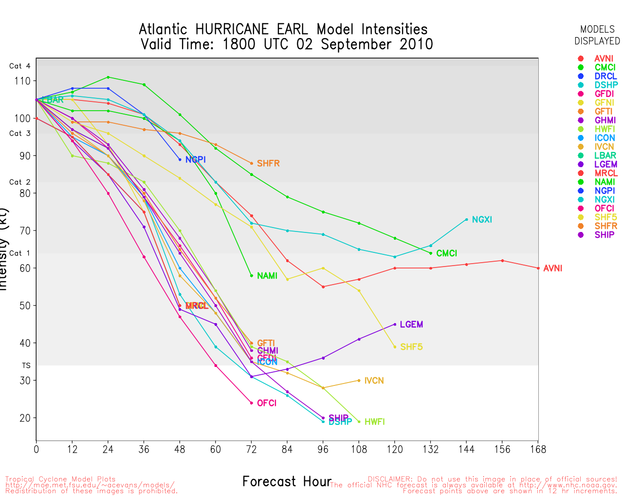
Clark Evans Intensity Model Plot of Earl (Animated!)
Clark Evans Track Plot of Earl
Other Model Charts from Clark
Clark Evans Top 10 Analog Storms for Earl
More model runs on from RAL/Jonathan Vigh's page
NRL Info on Earl -- RAMMB Info
COD Atlantic Satellite View
97L Event Related Links


SFWMD Model Plot (Animated Model Plot) SFWMD Hurricane Page
[https://flhurricane.com/floatanimator.php?year=2010&storm=8 Flhurricane Satellite Floater Animation of 97L
GOES Floater
Animated Model Plot of 97L
Clark Evans Track Model Plot of 97L
(Animated!) Model Plots in Google Earth - In Google Maps
Clark Evans Intensity Model Plot of 97L (Animated!)
Clark Evans Track Plot of 97L
Other Model Charts from Clark
Clark Evans Top 10 Analog Storms for 97L
More model runs on from RAL/Jonathan Vigh's page
NRL Info on 97L -- RAMMB Info
COD Atlantic Satellite View
5PM EDT Friday, 27 August 2010 update
Tropical Storm watches have been issued for the French Saint Maartin and st. Barthelemy. The Northern Leeward islands are in the Cone for Earl. Odds still favor Earl turning out to sea before (but very close to) the leewards. After that the most likely outcome will for Earl to stay out to sea, but it will be worth watching in case anything changes. Odds are about 87% for the system NOT reaching the US.
Tropical Storm watches also have been issued for Bermuda, as there is a chance they may see Tropical Storm force winds as Danielle moves by, but it will not be close enough for Hurricane force winds.
Note Earl is still most likely to recurve after nearing the Leewards, but 97L which may be Fiona by the end of the weekend, has much less chance to recurve, and may be worth watching by labor day weekend.
Original update
With three systems, including Danielle, which has reached major hurricane status, and jumped up to Category 4 from there, being the first major storm of the season, to Earl, being held back by the Saharan air level, along with a wave east of there (97)L that probably will form tonight or over the weekend, we find none of them likely to affect the US mainland, or even the Caribbean, but there is enough of a chance for those in the Leeward islands to keep close watch.
These systems will cause a fairly good amount of swell along the eastern US Coastline which could bring some rip currents and rough surf to many areas.
Danielle, strong as it is now, is quickly moving toward recurve and out to sea, missing even Bermuda, odds currently are around 98 out of a 100 it does not affect land. Danielle has about another day or two to slowly strengthen even more before encountering more hostile atmospheric conditions that would likely stop it from strengthening or weaken it.
Earl has been held back by atmospheric conditions, but the conditions are improving, and Earl has a good shot at slowly strengthening over the next few days. It has a chance to reach major hurricane by the time it is northeast of the islands. Odds currently are about 51% it will not affect the eastern Caribbean islands directly, and about 85% for not reaching the US. Those in the Northern Leeward islands of the Caribbean will want to watch closely for any changes.
97L has a fairly good shot to develop 60-70% either tonight or tomorrow, following in the steps of the other two systems, it is likely to get further west than the others, but odds still favor this one going out to sea as well. 55% for NOT getting the East Caribbean, 60% for not getting toward the US.. Of the three systems, though, this is the one most prime for change, but it requires the more complex situation to occur, so therefore a bit less likely that it won't recurve before land.
Beyond that there are more waves over Africa, and nothing imminent closer to home.
Edited by Ed Dunham (Sun Aug 29 2010 12:23 AM)
|
MikeC
Admin
Reged: Sun
Posts: 4543
Loc: Orlando, FL
|
|
Note, chances for Leeward island effect in Earl went up a bit, so those in the Leeward islands of the Caribbean will want to watch the trends with Earl. Odds are it will still pass to the north, but there is enough uncertainty that makes it very much worth watching.
|
Doombot!
Weather Guru

Reged: Sat
Posts: 160
Loc: Lakeland, Fl.
|
|
I normally hate the "what are the chances it going to hit 5.2 miles south of bumsville" posts, however some models (BAM's in particular) keep bumping Earl more left each run. Are these models picking up on a more westerly weakness in the ridge or no weakness in the ridge?
Obviously, the first version recurves while the latter would be more interesting (not really in a good way).
D!
|
MikeC
Admin
Reged: Sun
Posts: 4543
Loc: Orlando, FL
|
|
Recon is out in Danielle now and pressure may be around 942mb. Earl is getting a little bit of shear and some dry air affecting it. So, in this case, the idea of "weaker further west" may apply (It doesn't always). This increases the chance for a Leeward island effect somewhat.
Danielle moving out strengthens the ridge (or gives it more time to back fill), which could keep the system moving more westerly/perhaps slow down a bit. Still odds favor recurve at the moment, but confidence is low.
|
scottsvb
Weather Master
Reged: Mon
Posts: 1184
Loc: fl
|
|
Problem with Earl was mostly decoupling and multiple mid level centers along with some SAL. Earl had its mid level center push WNW yesterday while the LLC moved pretty much due W. Still with ridging to its north.. the MLC late last night into today has moved little and is weakening around 16.4N and 44.2W While another MLC is out just ahead of the LLC near 16.4N and 45.6W. The estimated LLC is closer to 15.8N and 45.3W.
Now Earl is around 1002mbs and with warmer SSTS coming going over tonight and light shear.. I expect Earl to consolidate with the MLC just out infront of the LLC. When this happens later this evening and into tonight.. I expect a pressure drop into the mid 990s. It's a guess of course cause we don't have the knowledge and technology to accurately predict such events for certain. But 994-997mb by 11am on Sat would be my guess unless the MLC stays out infront of the LLC.
Path is straight forward to just north of the Leeward islands by Monday-Monday night. I would expect TS watches to go up on Saturday. After that.. its for the forecast lounge and a guess cause after 72hrs,things can change faster.
|
LoisCane
Veteran Storm Chaser

Reged: Fri
Posts: 1236
Loc: South Florida
|
|
Scott that was the best discussion I have read anywhere on a very complicated storm and situation regarding Earl. Between reading discussion on how he will be a cat 4 one place but possibly be somewhere else if he is lower and to the south...
You can't have this storm become a Cat 4 anywhere, it's a locational question... if it tracks west it is in a different area and environment that if its north of the islands headed towards the turks..
It's a set up that relies on so many variables and you explained the inner workings well and why he is where he is...
My question is where is he going and as what? And, it's complicated... especially if you have to take into consideration two other storms.
--------------------
http://hurricaneharbor.blogspot.com/
|
MikeC
Admin
Reged: Sun
Posts: 4543
Loc: Orlando, FL
|
|
Odds are going are starting to go up that Earl will recurve, thankfully, but still maybe not enough for a side brushing of the Leewards. 97L still probably remains the most likely not to recurve, but it has a ways off (lounge territory).
|
weathernet
Storm Tracker
Reged: Sat
Posts: 296
Loc: Elsewhere
|
|
With Earl possibly speeding up, there would seem to be reasonable logic that interaction with Danielle "infused" W. Atlantic trough is all the more likely to occur. That and a stronger consensus of model support certainly makes for a compelling assumption that Earl will likely begin to re-curve prior to reaching the Lesser Antilles. Baring any unforeseen ridging that might expand westward from the Central Atlantic, it would seem rather unlikely that Earl would not gain at least a few degrees latitude prior to reaching 60 west. Given the appearant long range 500mb as depicted by today's Euro and , I still believe that Earl does possess a greater risk of getting caught under a sprawling Eastern U.S. ridge, than our next invest south of the Cape Verde Islands. At least for now, long range maps would seem to indicate adequate troughing over the Eastern U.S. at that time, and thus potentially posing a seemingly lessor threat unless such a system were to travel westward at a very low latitude.
|
typhoon_tip
Meteorologist
Reged: Wed
Posts: 576
|
|
Let us not be fooled by Earl's ragged appearance in satellite late this day. This system has a massive circulation field comparative to typical for a system of this intensity, and therefor has a lot of integrate energy already. This TC has the potential to become quite large and powerful.
Looking at the CIMSS SAL analysis the contamination is beginning to homogenize into the surrounding medium. If it were just dry air, such as a subsidence ring (not a-typical to mote at TC with one) then this would have been less of an issue. That said, Earl appears to be heading into a region with very good to excellent U/A outflow potential, this should allow for unimpeded growth given to the anomalously warm SSTs. Large systems tend to evolve more slowly, so it will be interesting to observe how Earl taps into these factors over the next 48 hours. By Monday we should have a large and intense hurricane.
I don't want to put a lot of stock in these D5+ forecasts. Too much of that depends on the exact handling of the eastern North American and western Atlantic Basin synoptic evolution, much of which has been stochastic in the models with regard to all important details that could make for big positional changes. I do want to add, however, that sampling the area N of 25N around 50-60W will be very important for Earl's track beyond D3..4. The reason is because TC of Danielle's ilk will leave a huge influx of latent heat into the surrounding medium, and that will affect the post ridge strength at mid levels ... ultimately playing into the steering fields farther south when the time comes. This "might" be causal in some of this apparent left shifting in recent runs. I would be leary, however, of the BAMS and BAMM as they are limited layer models, where as the BAMD has more levels.
Edited by typhoon_tip (Fri Aug 27 2010 07:12 PM)
|
Ed Dunham
Former Meteorologist & CFHC Forum Moderator (Ed Passed Away on May 14, 2017)
Reged: Sun
Posts: 2565
Loc: Melbourne, FL
|
|
At 5AM EDT this morning Earl was about 10 miles north of Danielle's track through this area of the basin. At 11AM it was 5 miles north of that track and at 5PM it was about 25 miles south of her track - when Danielle was a hurricane - at one point an 85 knot hurricane. I'm surprised that nobody has picked up on this (not even - at least I haven't seen this fact mentioned in any of their discussions). One of the reasons that Earl is having some difficulty in getting its act together is probably upwelling. Upwelling can occur even in tropical waters. Last night when I was trying to find some reasonable cause for Earl's slow response I simply overlaid the two tracks - and bingo!
Cheers,
ED
|
WeatherNut
Weather Master
Reged: Wed
Posts: 412
Loc: Atlanta, GA
|
|
Either the motion has been wsw or the center has reformed south it looks like...at least the MLC is looking like it is consolidating a bit south of where it was earlier
--------------------
Born into Cleo (64)...been stuck on em ever since
|
scottsvb
Weather Master
Reged: Mon
Posts: 1184
Loc: fl
|
|
moving about 260-265dg.... just south of due west.. you can see the
midlevel flow racing out ahead of Earl showing the movement ahead
of it. This general W to just south of W motion should continue till about 53-55W
then W to just north of W motion to near 17.5-18.5N and 60W... I wouldnt be
shocked if it was more like 17W and 60N in 2 days.
Update says that the movement is 275dg still but he is
uncertain @ best. We take his word for it..but I think
its still more 265dg and its elongated he said.
We will see by morning.
Edited by scottsvb (Fri Aug 27 2010 11:03 PM)
|
typhoon_tip
Meteorologist
Reged: Wed
Posts: 576
|
|
It's an interesting idea wrt upwelling; I did consider this but ... Danielle was one system so far in an oceanic arena that has positive anomalies in oceanic heat content over a large area - I've been toying with the idea that the SSTs are not perturbed enough by Danielle. High resolution infrared of the SSTs may shed some light, though I haven't had the time.
What I did notice though is that Danielle weakened for a stint when also passing near these same longitudes, which was also similar in spatial-temporal positioning to when Earl also encountered SAL per CIMSS. That specific commonality is what led me to thinking along the lines of more atmospheric dynamics.
Either way, I think Earl is headed toward being an impressive TC. Whether upwelling or SAL aside (probably both to some degree respectively) both factors would be escaped along this current trajectory placing Early in a region where neither would mitigate strengthening.
|
Evan Johnson
Weather Guru

Reged: Fri
Posts: 143
Loc: Loxahatchee, FL
|
|
is it me or are the model trends just doing nothing but shifting westward with less grouping? taking notice to the plots of the model runs from yesterday (27th 16:52) which showed tight grouping with most of the models pushing through bermuda, to today (28th 11:07) which indicates that most of the models that were run, place this thing very well due west of bermuda. on top of that it seems as time goes by the model runs dont really have a grasp on whats going on. is this something that we should pay a little closer attention to? a side note, i really do not see this following the same exact path as danielle as originally thought. i think from the get go this was too far south for that.
|
MichaelA
Weather Analyst

Reged: Thu
Posts: 945
Loc: Pinellas Park, FL
|
|
As Earl remains a TS, it should continue to track generally westward. It looks like the shear that Danielle's outflow induced is now weakening and Earl should, once again, begin strengthening. Only time will tell if the forecast weakness in the ridge north of Earl will be sufficient to allow for a turn to the NW or not. Folks along the eastern seaboard should, at least, be aware of Earl and stay informed on its whereabouts in the next few days.
--------------------
Michael
PWS
|
Beach
Weather Guru

Reged: Wed
Posts: 187
Loc: Cocoa Beach/Banana River
|
|
I can't remember when a Hurricane developed from a TS moving at 23mph. The pressure is up just bit, he needs to hit the brakes and take a moment otherwise he will tear himself apart. My thoughts anyways.
|
danielw
Moderator

Reged: Wed
Posts: 3525
Loc: Hattiesburg,MS (31.3N 89.3W)
|
|
Currently NOAA has 2 aircraft sampling the atmosphere in and around Earl. The NOAA Gulfstream aircraft is performing high altitude data sampling and NOAA 43 is performing a standard RECON pattern around Earl.
A recent drop in the "Eye" reported a sea level pressure of 991mb.
Flight data reported an Extrap. SFC. Press:983.3 mb (~ 29.04 inHg)
Earl is currently a bit under the pressure wind relationship curve as 991mb gives a maximum possible windspeed of 84 mph. This is probably due in part to Earl's rapid forward speed of West at 23 mph.
Edited by danielw (Sat Aug 28 2010 08:11 PM)
|
danielw
Moderator
Reged: Wed
Posts: 3525
Loc: Hattiesburg,MS (31.3N 89.3W)
|
|
Latest Advisory raises the wind speed and dropped the pressure.
TROPICAL STORM EARL INTERMEDIATE ADVISORY NUMBER 14A
NWS TPC/NATIONAL HURRICANE CENTER MIAMI FL AL072010
800 PM AST SAT AUG 28 2010
...EARL HEADING TOWARD THE LEEWARD ISLANDS IN A HURRY...
SUMMARY OF 800 PM AST...0000 UTC...INFORMATION
----------------------------------------------
LOCATION...16.5N 54.6W
ABOUT 570 MI...920 KM E OF THE NORTHERN LEEWARD ISLANDS
MAXIMUM SUSTAINED WINDS...65 MPH...105 KM/HR
PRESENT MOVEMENT...W OR 280 DEGREES AT 21 MPH...34 KM/HR
MINIMUM CENTRAL PRESSURE...989 MB...29.20 INCHES
|
bw
Registered User
Reged: Sat
Posts: 2
|
|
My wife and I are vacationing in St. Croix at the present time. We have airline reservations back to Orlando via San Juan and Miami early Thursday morning (September 2). We would appreciate any information you could share with us. I knew when when we left Orlando this past Thursday that I would attract a hurricane. That's about the norm for us. Thanks.
|
weathernet
Storm Tracker
Reged: Sat
Posts: 296
Loc: Elsewhere
|
|
Earl "may" be slowing down a tad; whether be it a start of a bend more to the WNW or perhaps simply an effect of further organization and a deepening phase. Looks like the impressive bursting of convection might just cause a vorticity max. to rotate around the east and north side later tonight, thus possibly helping to gain a tad more latitude. Certainly nervous hours ahead this evening for those in the Islands ( St. Croix included ). Does anyone know if the data that today's recon missions have/are receiving, will be ingested into this evening 0Z run or if more likely to be ingested into later runs this evening?
On a seperate note, 97L is really convecting this evening and overall shape improving. Would not surprise me if we have a depression by daylight ( or even possibly skip right to Fiona? )
|


 Threaded


