danielw
Moderator

Reged:
Posts: 3525
Loc: Hattiesburg,MS (31.3N 89.3W)
|
|
Quote:
A 2nd dropsonde, this one in the outgoing eyewall, read 927mb surface pressure / 104kt surface winds. That is 5mb lower than the vortex recon reported the eye being only a few moments earlier. Weird.
Earl is shedding outer convective bands. Generally you only see this when a storm is becoming annular. Everyone needs to watch this storm very closely. Microwave shows no sign of an to weaken the storm anytime soon.
And the second drop was in the western eyewall of a 30nm eye. Did see a note about the eye being open to the south. If Earl closes that opening the pressure will continue to drop and windspeed will increase later tonight.
|
Random Chaos
Weather Analyst

Reged:
Posts: 1024
Loc: Maryland
|
|
Typhoon Tip said:
Quote:
Well ... we have our selves a real dicey situation up in eastern Long Island, RI and eastern/SE MA.
Taking readings off the spaghetti models from - the bulk of the tracks for the path of the eye fall in the following distances from these locations:
NC - Outer Banks: 10 to 140 miles
NY - Tip of Long Island: 80 to 210 miles
MA - Nantucket Island: 10 to 130 miles
The eye has a radius of around 20 miles. The deep convection surrounding the eye has a radius of around 50 to 80 miles, quadrant dependent.
Everyone along the east coast needs to watch this.
|
MikeC
Admin
Reged:
Posts: 4544
Loc: Orlando, FL
|
|
As far as movement, it appears to be stair-stepping, but generally following the forecast track,maybe a tad east.

It looks pretty likely the 11PM Advisory will show higher winds, it may just be under Category 5 strength. It has a shot at becoming annular too, but I'd be surprised if it did.
|
Random Chaos
Weather Analyst
Reged:
Posts: 1024
Loc: Maryland
|
|
Beautiful IR storm presentation...now if only I were further from its track!
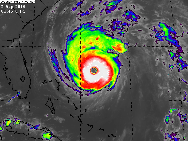
Quick note for people looking for IR images:
SSD is sometimes (not always) running 30 to 60 minutes behind MSFC for releasing IR images. This means for the most recent IR images, head over to MSFC. Their interface is harder to use and does not automatically update the images, so SSD is better for just running a monitoring animation. Not sure how other sites stack up in terms of release intervals.
SSD: http://www.ssd.noaa.gov/PS/TROP/float2.html
MSFC: http://weather.msfc.nasa.gov/GOES/goeseasthurrir.html
Edited by Random Chaos (Thu Sep 02 2010 02:27 AM)
|
danielw
Moderator
Reged:
Posts: 3525
Loc: Hattiesburg,MS (31.3N 89.3W)
|
|
I hope that you are out of reach of the tides there. R.C.
Latest wv imagery loop has Earl on a track between 315 and 320 degrees, or NW.
Using the forecast points, the southern eyewall edge was on the north edge of the 00Z forecast point. Will have to see how well he stays on track at the next point.
Jim cantore signed off at 10 PM tonight and told folks to remember Hurricane . He said be prepared in case it makes a last minute turn like did.
You can bet there is a whole lot of bandwidth in use tonight on the East Coast. And not much sleeping being accomplished.
Mandatory Evacuations begin in parts of NC at 5 AM EDT.
EDited for spelling, etc.
Edited by Ed Dunham (Thu Sep 02 2010 04:01 AM)
|
Random Chaos
Weather Analyst
Reged:
Posts: 1024
Loc: Maryland
|
|
I was wondering about that. Land drag is not included into the model guidance and has a large effect on all storms that are near land. Given the size and proximity to land tomorrow, this could affect the course...negatively in my case.
|
danielw
Moderator
Reged:
Posts: 3525
Loc: Hattiesburg,MS (31.3N 89.3W)
|
|
I looked at the latest SHIPS model and it's only showing 2 kts difference between over water and over land for the next 36 hours. Too much vorticity/ helicity keeping Earl going I guess.
Latest data is showing a 50 mile near miss at Hatteras. That's 50 miles minus the diameter of the eye using the current forecast track.
That's just too close for any comfort.
Edited by danielw (Thu Sep 02 2010 04:31 AM)
|
ftlaudbob
Storm Chaser

Reged:
Posts: 828
Loc: Valladolid,Mx
|
|
Earl is looking like a perfect hurricane.Those people in the Carolinas and New England better prepare for a major hurricane.This is very real,and Earl means business.
--------------------
Survived: 10 hurricanes in Rhode Island,Florida and the Yucatan of Mexico .
|
Storm Hunter
Veteran Storm Chaser

Reged:
Posts: 1370
Loc: Panama City Beach, Fl.
|
|
AFR just made a pass from SE to NW... appears Earl might have about 2-3mb lower pressure
--------------------
www.Stormhunter7.com ***see my flight into Hurricane Ike ***
Wx Data: KFLPANAM23 / CW8771
2012== 23/10/9/5 sys/strms/hurr/majh
|
danielw
Moderator
Reged:
Posts: 3525
Loc: Hattiesburg,MS (31.3N 89.3W)
|
|
09/02 05:30:30Z 926.4mb (~27.36 inHg)
Topped another record low pressure in the Western Atlantic.
Hurricane Andrew 1992 had 922mb at FL Landfall.
I'm not sure if this NOAA report from earlier will be a record as it's about 1500 feet above the surface. But it's got to be in the top 10 Western Atlantic dropsonde windspeeds:
895mb 60° (from the ENE) 173 knots (199 mph)
Edited by danielw (Thu Sep 02 2010 06:08 AM)
|
Storm Hunter
Veteran Storm Chaser
Reged:
Posts: 1370
Loc: Panama City Beach, Fl.
|
|
Yeah... thats just amazing!
Here's the dropsonde data!
http://www.tropicalatlantic.com/recon/ar...;product=UZNT13
--------------------
www.Stormhunter7.com ***see my flight into Hurricane Ike ***
Wx Data: KFLPANAM23 / CW8771
2012== 23/10/9/5 sys/strms/hurr/majh
Edited by Storm Hunter (Thu Sep 02 2010 06:41 AM)
|
danielw
Moderator
Reged:
Posts: 3525
Loc: Hattiesburg,MS (31.3N 89.3W)
|
|
Vortex hasn't arrived and no HDOB since 30 minutes ago.
Gulfstream just made a drop by Ed's house. So the data path is good.
AF300 is back online.
ftp showing 37 minutes between HDOBS. Roughride tonight?
Wind center at 05:29:00 28.26N 074.18W 926.4mb wind in eye from SE or 126deg at 005kt
Edited by danielw (Thu Sep 02 2010 06:40 AM)
|
Storm Hunter
Veteran Storm Chaser
Reged:
Posts: 1370
Loc: Panama City Beach, Fl.
|
|
Last check 5 mins ago, NASA Global hawk just flew over El Palso, TX... enroute to Earl! 
--------------------
www.Stormhunter7.com ***see my flight into Hurricane Ike ***
Wx Data: KFLPANAM23 / CW8771
2012== 23/10/9/5 sys/strms/hurr/majh
|
danielw
Moderator
Reged:
Posts: 3525
Loc: Hattiesburg,MS (31.3N 89.3W)
|
|
URNT12 KNHC 020605
VORTEX DATA MESSAGE AL072010
A. 02/05:29:00Z
B. 28 deg 26 min N
074 deg 18 min W
C. 700 mb 2494 m
D. 79 kt
E. 136 deg 15 nm
F. 230 deg 125 kt
G. 137 deg 17 nm
H. 931 mb
I. 16 C / 3063 m
J. 21 C / 3054 m
K. 10 C / NA
L. CLOSED WALL
M. C24
N. 12345 / 7
O. 0.02 / 1 nm
P. AF300 1207A EARL OB 06
MAX FL WIND 125 KT SE QUAD 05:24:10Z
MAX OUTBOUND SFC WIND 111 KTS NE QUAD AT 05:31:30 Z
FREQUENT SVR TURBC NW EYEWALL TO 10 NM FURTHER OUT.
So it looks like they are going to keep the 931mb. This was the SE NW leg right?
Edited by danielw (Thu Sep 02 2010 06:51 AM)
|
Storm Hunter
Veteran Storm Chaser
Reged:
Posts: 1370
Loc: Panama City Beach, Fl.
|
|
2am adv. has
THE MINIMUM CENTRAL PRESSURE JUST EXTRAPOLATED BY AN AIR FORCE
RESERVE HURRICANE HUNTER AIRCRAFT IS 930 MB...27.46 INCHES.
--------------------
www.Stormhunter7.com ***see my flight into Hurricane Ike ***
Wx Data: KFLPANAM23 / CW8771
2012== 23/10/9/5 sys/strms/hurr/majh
|
ftlaudbob
Storm Chaser
Reged:
Posts: 828
Loc: Valladolid,Mx
|
|
This pressure drop is amazing.Given that and the visible It is safe to say we have a monster on our hands.
--------------------
Survived: 10 hurricanes in Rhode Island,Florida and the Yucatan of Mexico .
|
Storm Hunter
Veteran Storm Chaser
Reged:
Posts: 1370
Loc: Panama City Beach, Fl.
|
|
Quote:
So it looks like they are going to keep the 931mb. This was the SE NW leg right?
appears so... plane is coming SW to NE now.. just got to eyewall on SW side.
--------------------
www.Stormhunter7.com ***see my flight into Hurricane Ike ***
Wx Data: KFLPANAM23 / CW8771
2012== 23/10/9/5 sys/strms/hurr/majh
|
danielw
Moderator
Reged:
Posts: 3525
Loc: Hattiesburg,MS (31.3N 89.3W)
|
|
Wind center at 07:05:00Z
28.767N 74.567W 924.8 mb(~ 27.31 inHg)
Seems an should be coming up. Earl's been steady state for a while now. I hate that it's someone's monster though.
|
Storm Hunter
Veteran Storm Chaser
Reged:
Posts: 1370
Loc: Panama City Beach, Fl.
|
|
Quote:
Wind center at 07:05:00Z
28.767N 74.567W 924.8 mb(~ 27.31 inHg)
Seems an should be coming up. Earl's been steady state for a while now. I hate that it's someone's monster though.
Well his width of eye was 30 miles yesterday evening... now down to 24 after 2am... so it may take a few more hours for the to begin i would think?
--------------------
www.Stormhunter7.com ***see my flight into Hurricane Ike ***
Wx Data: KFLPANAM23 / CW8771
2012== 23/10/9/5 sys/strms/hurr/majh
|
Storm Hunter
Veteran Storm Chaser
Reged:
Posts: 1370
Loc: Panama City Beach, Fl.
|
|
Product: Air Force Vortex Message (URNT12 KNHC)
Transmitted: 2nd day of the month at 07:30Z
Aircraft: Air Force Aircraft (Last 3 digits of the tail number are 300)
Storm Number & Year: 07L in 2010
Storm Name: Earl (flight in the North Atlantic basin)
Mission Number: 12
Observation Number: 10
A. Time of Center Fix: 2nd day of the month at 7:05:40Z
B. Center Fix Coordinates: 28°47'N 74°32'W (28.7833N 74.5333W)
B. Center Fix Location: 310 miles (499 km) to the NE (34°) from Nassau, Bahamas.
C. Minimum Height at Standard Level: 2,488m (8,163ft) at 700mb
D. Estimated (by SFMR or visually) Maximum Surface Wind: 104kts (~ 119.7mph)
E. Location of the Estimated Maximum Surface Wind: 6 nautical miles (7 statute miles) to the WSW (245°) of center fix
F. Maximum Flight Level Wind Inbound: From 333° at 111kts (From the NNW at ~ 127.7mph)
G. Location of Maximum Flight Level Wind Inbound: 8 nautical miles (9 statute miles) to the WSW (243°) of center fix
H. Minimum Sea Level Pressure: 929mb (27.43 inHg)
I. Maximum Flight Level Temp & Pressure Altitude Outside Eye: 11°C (52°F) at a pressure alt. of 3,051m (10,010ft)
J. Maximum Flight Level Temp & Pressure Altitude Inside Eye: 22°C (72°F) at a pressure alt. of 3,057m (10,030ft)
K. Dewpoint Temp (collected at same location as temp inside eye): 10°C (50°F)
K. Sea Surface Temp (collected at same location as temp inside eye): Not Available
L. Eye Character: Closed Wall
M. Eye Shape: Elliptical (oval shaped)
M. Orientation of Major Axis in Elliptical Eye: 340° to 160° (NNW to SSE)
M. Length of Major Axis in Elliptical Eye: 32 nautical miles (37 statute miles)
M. Length of Minor Axis in Elliptical Eye: 22 nautical miles (25 statute miles)
N. Fix Determined By: Penetration, Radar, Wind, Pressure and Temperature
N. Fix Level: 700mb
O. Navigation Fix Accuracy: 0.02 nautical miles
O. Meteorological Accuracy: 1 nautical mile
Remarks Section - Remarks That Were Decoded...
Maximum Wind Outbound: 141kts (~ 162.3mph) in the northeast quadrant at 7:10:50Z
Maximum Flight Level Wind: 141kts (~ 162.3mph) in the northeast quadrant at 7:10:50Z
Maximum Surface (likely estimated by SFMR) Wind Outbound: 117kts (~ 134.6mph) in the northwest quadrant at 7:10:10Z
Remarks Section - Additional Remarks...
INFRQT MDT TURBC SW AND NE EYEWALLS
--------------------
www.Stormhunter7.com ***see my flight into Hurricane Ike ***
Wx Data: KFLPANAM23 / CW8771
2012== 23/10/9/5 sys/strms/hurr/majh
Edited by Storm Hunter (Thu Sep 02 2010 07:39 AM)
|


 Threaded


