8AM EDT Update - Sunday, 5 September 2010
Earl is no longer, Ex-Gaston and an area in the Bay of Campeche (90L) Both have a chance to form today or tomorrow.
The area east of Gaston fell apart and is no longer being tracked as 99L.
90L has a chance to make tropical storm status before moving inland in Northern Mexico or extreme southern Texas, but it will not have the time to strengthen.
Ex-Gaston Event Related Links


SFWMD Model Plot (Animated Model Plot) SFWMD Hurricane Page
[https://flhurricane.com/floatanimator.php?year=2010&storm=9 Flhurricane Satellite Floater Animation of Ex-Gaston
GOES Floater
Animated Model Plot of Ex-Gaston
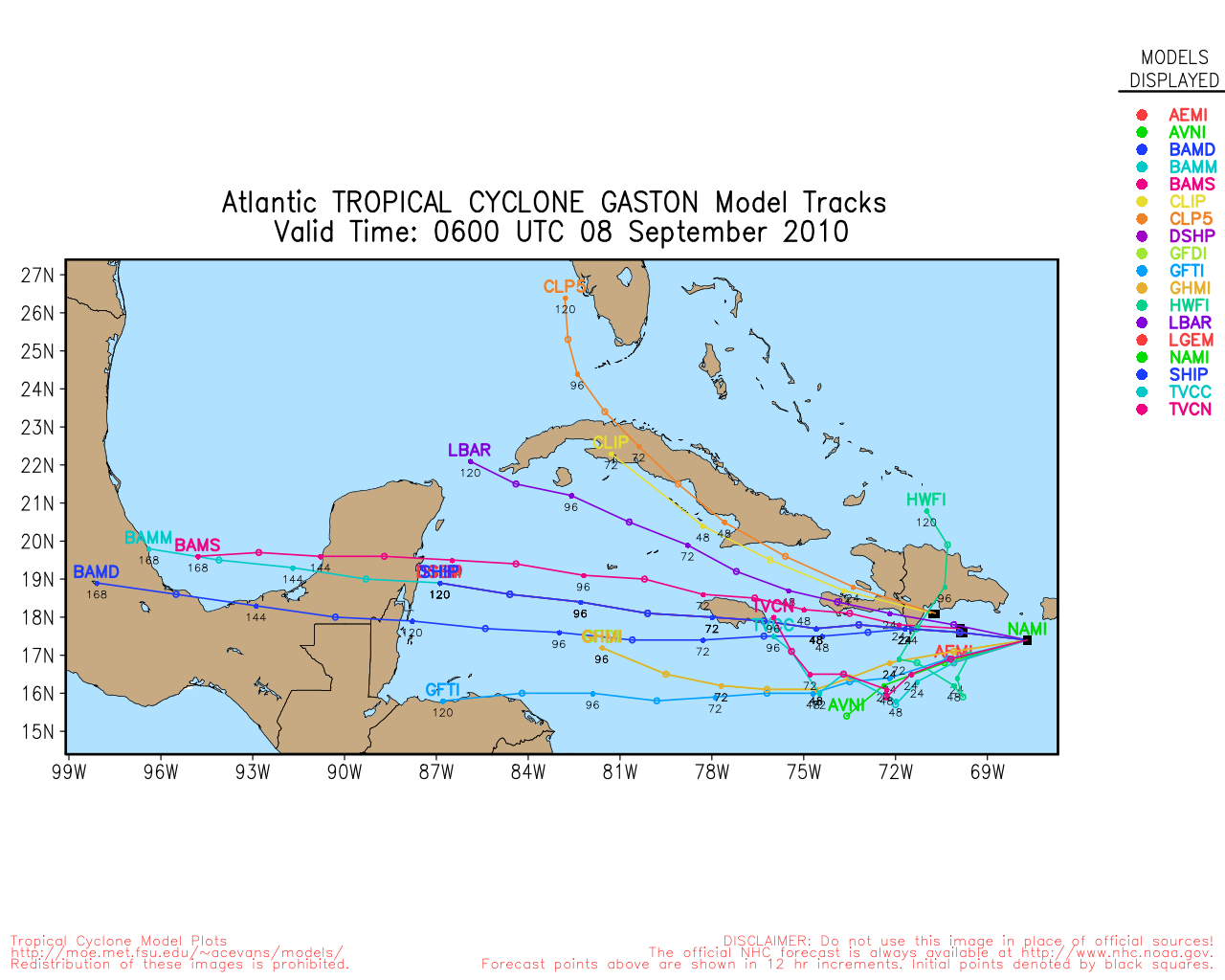
Clark Evans Track Model Plot of Ex-Gaston
(Animated!) Model Plots in Google Earth - In Google Maps
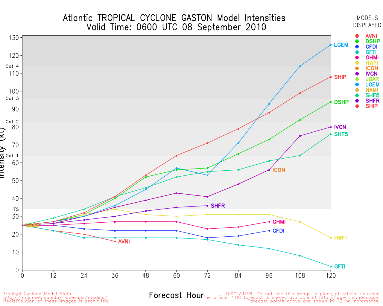
Clark Evans Intensity Model Plot of Ex-Gaston (Animated!)
Clark Evans Track Plot of Ex-Gaston
Other Model Charts from Clark
Clark Evans Top 10 Analog Storms for Ex-Gaston
More model runs on from RAL/Jonathan Vigh's page
NRL Info on Ex-Gaston -- RAMMB Info
COD Atlantic Satellite View
Invest 90L Event Related Links


SFWMD Model Plot (Animated Model Plot) SFWMD Hurricane Page
[https://flhurricane.com/floatanimator.php?year=2010&storm=10 Flhurricane Satellite Floater Animation of 90L
GOES Floater
Animated Model Plot of 90L
Clark Evans Track Model Plot of 90L
(Animated!) Model Plots in Google Earth - In Google Maps
Clark Evans Intensity Model Plot of 90L (Animated!)
Clark Evans Track Plot of 90L
Other Model Charts from Clark
Clark Evans Top 10 Analog Storms for 90L
More model runs on from RAL/Jonathan Vigh's page
NRL Info on 90L -- RAMMB Info
COD Atlantic Satellite View
b]4PM EDT Update - Saturday, 4 September 2010
Earl is inland over Nova Scotia in Canada. The remnants of Gaston are set to reform likely later tonight or tomorrow, and another disturbance in the Southwest Gulf of Mexico has a shot at forming into a Tropical Storm tomorrow before Landfall in Northeast Mexico or southern Texas (not currently an invest). And Fiona dissipated. The other system east of Ex-Gaston (99L) will have to be watched later in the week as well.
Gaston's Remnants are likely to edge along the Northern Leewards and just north and continue westward, so it appears the Bahamas and perhaps Florida will want to watch what happens with what was Gaston later this week. Those in the Leewards will want to watch even sooner because if it redevelops they will likely be in the cone.
StormCarib Reports from the Caribbean Islands
Caribbean Weather Observations
Barbados Brohav Weather Fax
Full Caribbean Radar Composite
Caribbean Broadcast Corporation (TV/Radio from Antilles)
San Juan, PR NWS Page
Various Caribbean Radio Stations
DR1 Dominican Republic Hurricanes
Earl Event Related Links


SFWMD Model Plot (Animated Model Plot) SFWMD Hurricane Page
[https://flhurricane.com/floatanimator.php?year=2010&storm=7 Flhurricane Satellite Floater Animation of Earl
GOES Floater
Animated Model Plot of Earl
Clark Evans Track Model Plot of Earl
(Animated!) Model Plots in Google Earth - In Google Maps
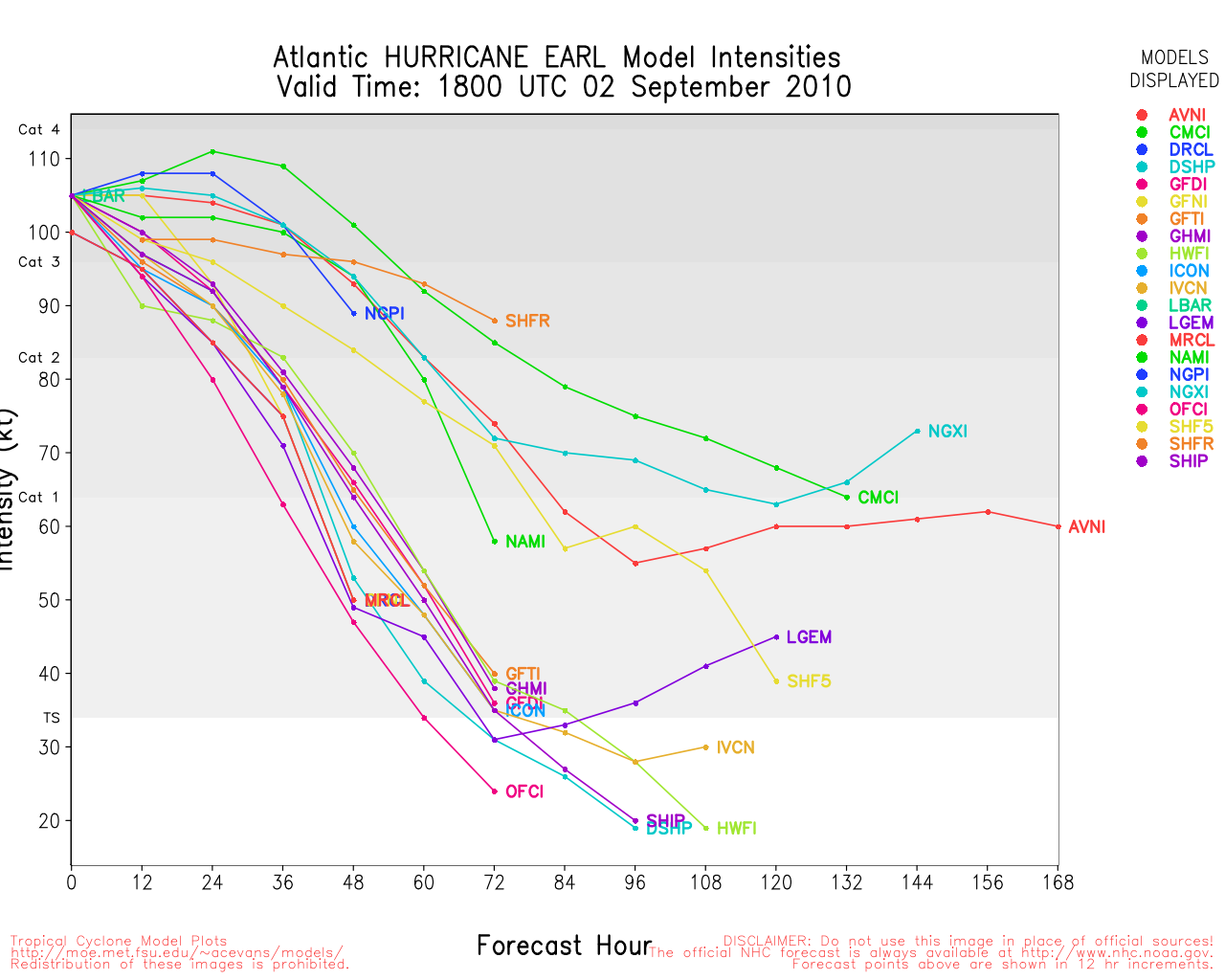
Clark Evans Intensity Model Plot of Earl (Animated!)
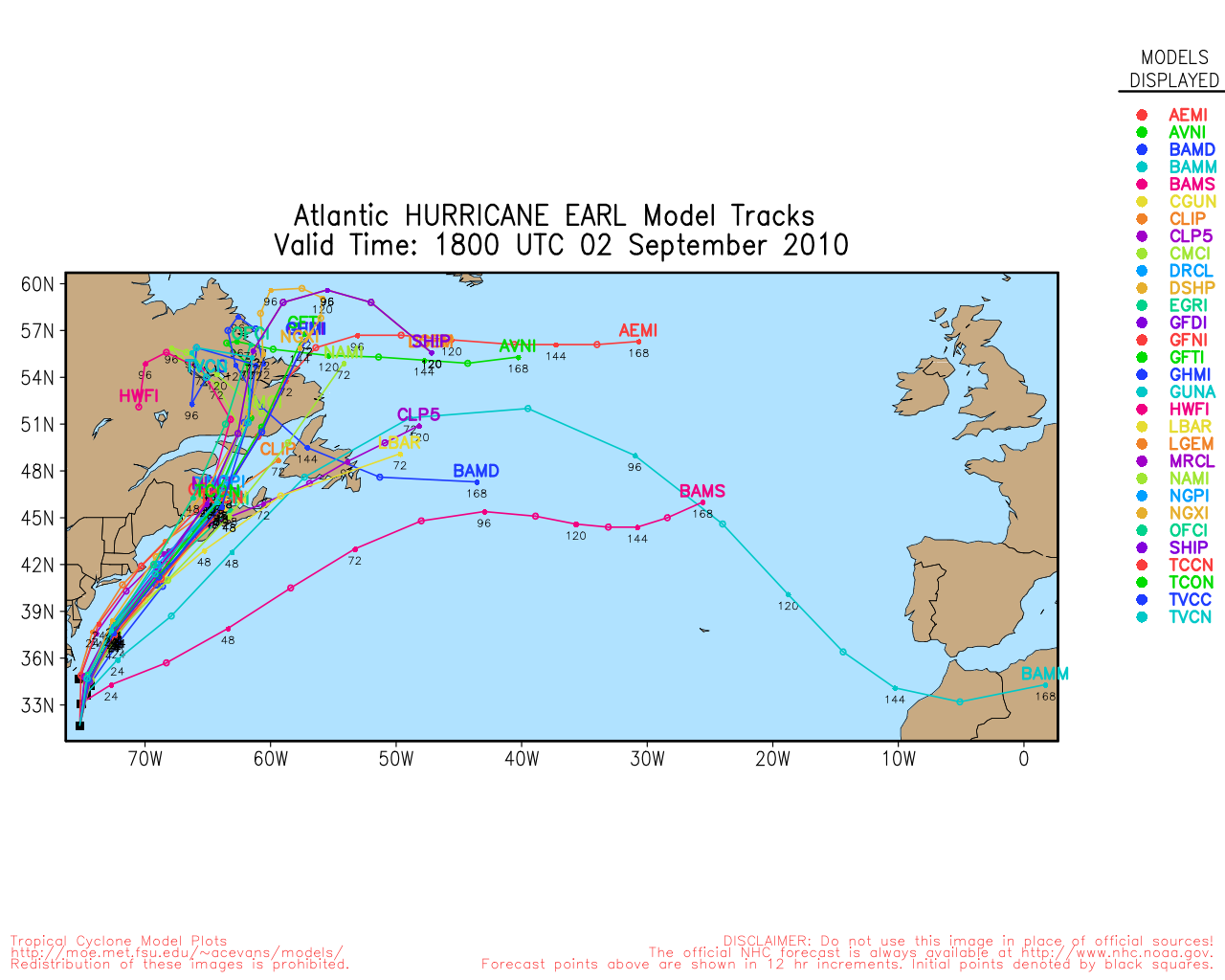
Clark Evans Track Plot of Earl
Other Model Charts from Clark
Clark Evans Top 10 Analog Storms for Earl
More model runs on from RAL/Jonathan Vigh's page
NRL Info on Earl -- RAMMB Info
COD Atlantic Satellite View
Ex-Gaston Event Related Links
SFWMD Model Plot (Animated Model Plot) SFWMD Hurricane Page
[https://flhurricane.com/floatanimator.php?year=2010&storm=9 Flhurricane Satellite Floater Animation of Ex-Gaston
GOES Floater
Animated Model Plot of Ex-Gaston
Clark Evans Track Model Plot of Ex-Gaston
(Animated!) Model Plots in Google Earth - In Google Maps
Clark Evans Intensity Model Plot of Ex-Gaston (Animated!)
Clark Evans Track Plot of Ex-Gaston
Other Model Charts from Clark
Clark Evans Top 10 Analog Storms for Ex-Gaston
More model runs on from RAL/Jonathan Vigh's page
NRL Info on Ex-Gaston -- RAMMB Info
COD Atlantic Satellite View
Invest 99L Event Related Links
SFWMD Model Plot (Animated Model Plot) SFWMD Hurricane Page
[https://flhurricane.com/floatanimator.php?year=2010&storm=10 Flhurricane Satellite Floater Animation of 99L
GOES Floater
Animated Model Plot of 99L
Clark Evans Track Model Plot of 99L
(Animated!) Model Plots in Google Earth - In Google Maps
Clark Evans Intensity Model Plot of 99L (Animated!)
Clark Evans Track Plot of 99L
Other Model Charts from Clark
Clark Evans Top 10 Analog Storms for 99L
More model runs on from RAL/Jonathan Vigh's page
NRL Info on 99L -- RAMMB Info
COD Atlantic Satellite View
11PM EDT Update - Friday, 3 September 2010
Earl is now a strong Tropical Storm moving about 80 miles southeast of Cape Cod and heading toward eastern Nova Scotia on Saturday. Sustained winds are now at 60 knots and Earl is moving to the northeast at 22 knots. Updated Warnings and Watches are listed in the Meteorological Blog.
New England Hourly Weather Reports
Fiona has degenerated into a remnant low that is expected to dissipate over the weekend.
The former Gaston is once again developing deep convection and will likely become a tropical cyclone again over the weekend as the system moves to the west northwest.
Invest 99L is slowly organizing off the west coast of Africa as it moves to the northwest at about 8 knots. Still not certain as to whether 99L will be able to survive the dry air environment that it is moving into.
ED
7:00 AM EDT Update Friday, 3 September 2010
t

Earl is Northeast of Cape Hatteras this morning, and most of the wind has stayed offshore, with the extreme eastern outer banks seeing strong tropical storm force winds.
Hurricane Earl is expected to near Cape Code in the Early Morning hours tomorrow.
8:30 PM EDT Update Thursday, 2 September 2010
Earl is nearing the North Carolina Coastline, but is moving more northerly now and thankfully, it appears the center of the system will not make landfall, although winds will be very high. Earl has weakened to a category 2 storm
Those in the Cape Cod area will like also see a very close call.
Gaston has been downgraded to an open wave, but may regenerate later and will be watched.
Mid-Atlantic/Carolina Links
Southeast Composite Radar Loop
(Latest Static)
Charleston, SC Radar Radar Loop
(Latest Static)
Wilmington, NC Radar Radar Loop
(Latest Static)
Morehead City, NC Radar Radar Loop
(Latest Static)
Norfolk/Wakefield, VA Radar Radar Loop
(Latest Static)
Area Forecast Discussions:
Charleston, SC -
Wilmington, NC -
Morehead City, NC -
Norfolk/Virginia Beach/Hampton Roads, VA
Power Outage Maps:
South Carolina Power Outage Map
North Carolina Power Outage Map
Virginia Power Outage Map
Southeast Composite Radar Loop
(Latest Static)
Northeast Composite Radar Loop
(Latest Static)
Northeast US Radar Links
Northeast Composite Radar Loop
(Latest Static)
Dover, DE Radar Radar Loop
(Latest Static)
Mt. Holly, NJ Radar Radar Loop
(Latest Static)
Upton/NYC/Long Island, NY Radar Radar Loop
(Latest Static)
Boston/Cape Cod, MA Radar Radar Loop
(Latest Static)
Portland, ME Radar Radar Loop
(Latest Static)
Carabou, ME Radar Radar Loop
(Latest Static)
Flhurricane Recording of Radar (and more) of Earl US Approach
Keep up with where Mark Sudduth (Hurricanetrack.com) is as he drives around the Outer Banks of North Carolina
Hatteras Lighthouse Cam flhurricane recording
Kill Devil Hills Pier Video Stream
Flhurricane recording of HurricaneTrack's Tower Cam
Media:
WECT 6TV - Wilmington, NC
WITN 7 - Eastern North Carolina TV (NBC)
WCTI 12 - Eastern North Carolina (ABC)
WNCT TV 9 - Eastern North Carolina (CBS)
Wavy 10 (NBC) - Hampton Roads/VA Beach, VA TV
WTKR 3 (CBS) - Hampton Roads/VA Beach, VA
WVEC 13 (ABC) - Hampton Roads/VA Beach, VA
Papers:
Outer Banks Sentinel
Wilmington Star News Online
Hampton Roads Pilot
Keep up with where Mark Sudduth (Hurricanetrack.com) is as he drives around the Outer Banks of North Carolina
Canadian Hurricane Centre
Flhurricane Recording of French Antilles radar for FIona Approach
StormCarib Reports from the Caribbean Islands
Caribbean Weather Observations
Barbados Brohav Weather Fax
Full Caribbean Radar Composite
Caribbean Broadcast Corporation (TV/Radio from Antilles)
San Juan, PR NWS Page
Various Caribbean Radio Stations
DR1 Dominican Republic Hurricanes
Earl Event Related Links
SFWMD Model Plot (Animated Model Plot) SFWMD Hurricane Page
[https://flhurricane.com/floatanimator.php?year=2010&storm=7 Flhurricane Satellite Floater Animation of Earl
GOES Floater
Animated Model Plot of Earl
Clark Evans Track Model Plot of Earl
(Animated!) Model Plots in Google Earth - In Google Maps
Clark Evans Intensity Model Plot of Earl (Animated!)
Clark Evans Track Plot of Earl
Other Model Charts from Clark
Clark Evans Top 10 Analog Storms for Earl
More model runs on from RAL/Jonathan Vigh's page
NRL Info on Earl -- RAMMB Info
COD Atlantic Satellite View
Fiona Event Related Links


SFWMD Model Plot (Animated Model Plot) SFWMD Hurricane Page
[https://flhurricane.com/floatanimator.php?year=2010&storm=8 Flhurricane Satellite Floater Animation of Fiona
GOES Floater
Animated Model Plot of Fiona
Clark Evans Track Model Plot of Fiona
(Animated!) Model Plots in Google Earth - In Google Maps
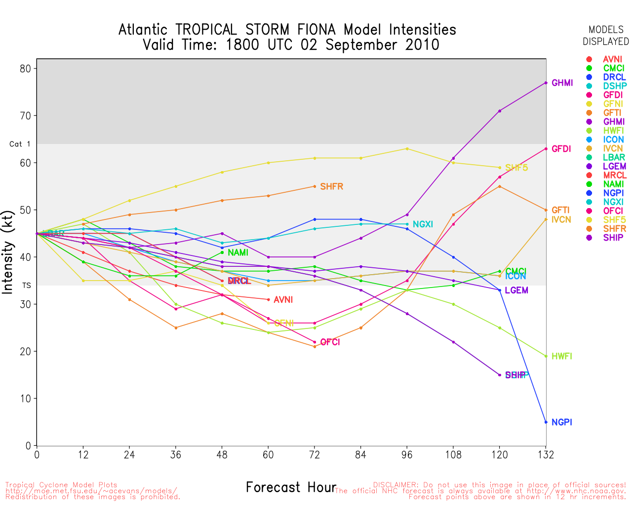
Clark Evans Intensity Model Plot of Fiona (Animated!)
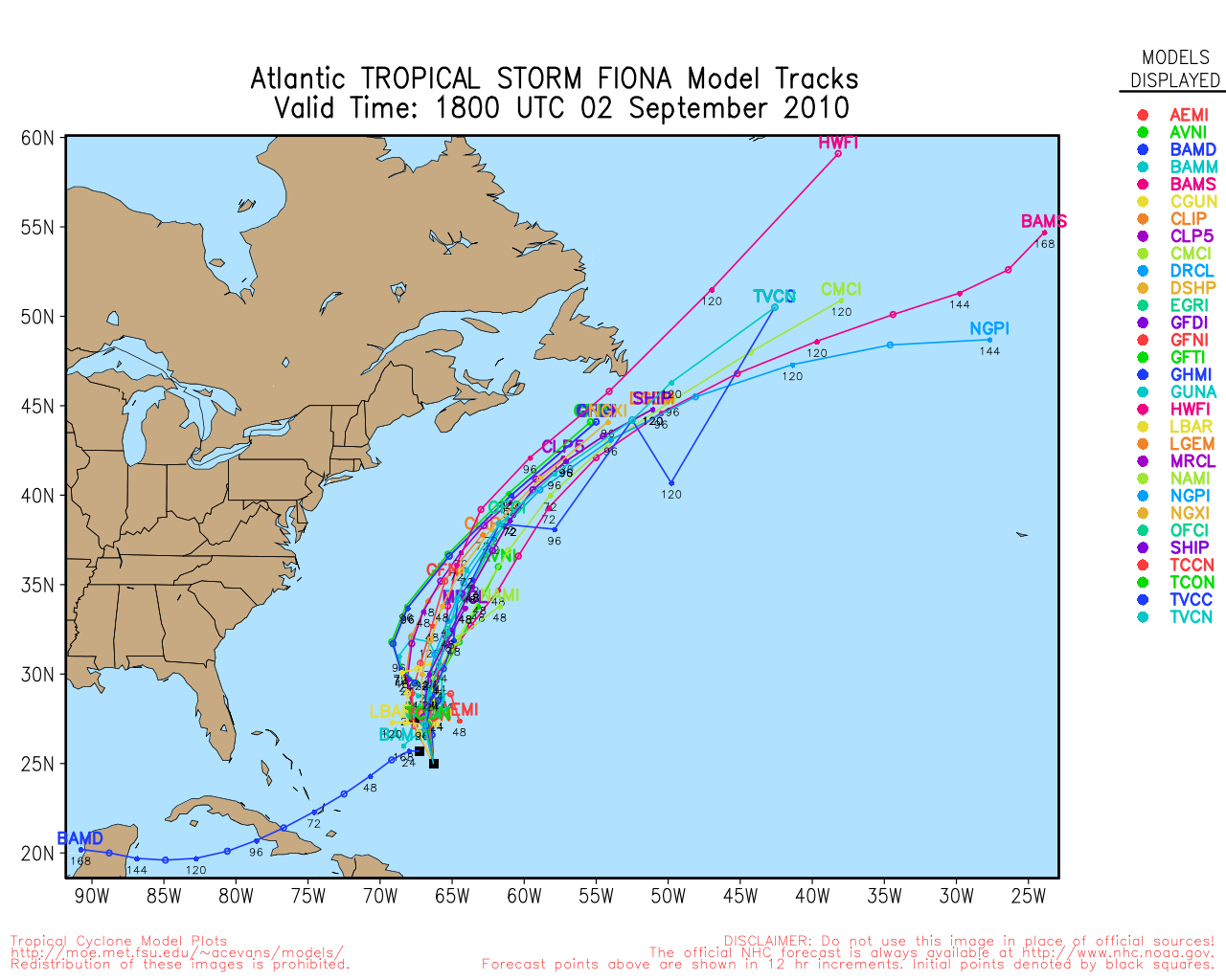
Clark Evans Track Plot of Fiona
Other Model Charts from Clark
Clark Evans Top 10 Analog Storms for Fiona
More model runs on from RAL/Jonathan Vigh's page
NRL Info on Fiona -- RAMMB Info
COD Atlantic Satellite View
Gaston Event Related Links
SFWMD Model Plot (Animated Model Plot) SFWMD Hurricane Page
[https://flhurricane.com/floatanimator.php?year=2010&storm=9 Flhurricane Satellite Floater Animation of Gaston
GOES Floater
Animated Model Plot of Gaston
Clark Evans Track Model Plot of Gaston
(Animated!) Model Plots in Google Earth - In Google Maps
Clark Evans Intensity Model Plot of Gaston (Animated!)
Clark Evans Track Plot of Gaston
Other Model Charts from Clark
Clark Evans Top 10 Analog Storms for Gaston
More model runs on from RAL/Jonathan Vigh's page
NRL Info on Gaston -- RAMMB Info
COD Atlantic Satellite View
Invest 99L Event Related Links
SFWMD Model Plot (Animated Model Plot) SFWMD Hurricane Page
[https://flhurricane.com/floatanimator.php?year=2010&storm=10 Flhurricane Satellite Floater Animation of 99L
GOES Floater
Animated Model Plot of 99L
Clark Evans Track Model Plot of 99L
(Animated!) Model Plots in Google Earth - In Google Maps
Clark Evans Intensity Model Plot of 99L (Animated!)
Clark Evans Track Plot of 99L
Other Model Charts from Clark
Clark Evans Top 10 Analog Storms for 99L
More model runs on from RAL/Jonathan Vigh's page
NRL Info on 99L -- RAMMB Info
COD Atlantic Satellite View
6:15 AM EDT Update Thursday, 2 September 2010
Hurricane Earl has probably peaked earlier this morning, but remains a strong category 4 storm. It is forecast to come very close (40-60 miles) of the outer banks, still as a major hurricane. Any deviation to the west would bring the worst of it onshore. Those in the warning areas should pay attention to local media and officials about any evacuations or recommendations.
Today should be spent in final preparations and leaving as conditions will begin to deteriorate in North Carolina in the late afternoon or evening. Closest approach to North Carolina would likely bit in pre-dawn hours tomorrow.
After passing near/over North Carolina, Earl is forecast to stay offshore the mid Atlantic, but Nantucket has a chance to get part of the western eyewall. Because of this hurricane watches are in effect now (in addition to the other warnings/watches) from north of the NC/VA Border to Cape Henlopen in Delaware. And now also from westport to Plymouth, MA (along with cape code/Martha's Vineyard and Nantucket) Those in Martha's Vineyard and Nantucket would be wise to begin preparations now.

Wind fields tend to expand when the storms get further north, so there is a good chance a large area in the northeast may experience some strong winds.
Beyond that, Extreme Northeast Maine may be a landfall, and Canada will either way, and it is likely Earl still will be a hurricane when it does.
Fiona is on the out to sea path, but has a chance to come close to Bermuda (on the west side). Therefore Bermuda is under a Tropical Storm watch for FIona.
Gaston is remaining weak this morning, but expected to continue to track west. Gaston is moving much slower than the other storms, and may not reach closer to the Leeward islands until mid-late next week. Odds favor Gaston not going out to sea, so it will be one to watch then.
Beyond Gaston is another wave (not being tracked as a proper invest yet) that has a 10% chance to develop over the next 48 hours, but more of one later on.
8:30PM EDT Update Wednesday 1 September 2010
Recon airfract has found a lower pressure in Earl of 932mb, which indicates Earl is continuing to strengthen.
Those still on the outer banks are highly recommended not to take the risk of a major storm approaching your area and leave.
Odds favor the center of it staying offshore, but the large size will still pound hurricane force winds along parts of the coast.


6:00PM EDT Update Wednesday 1 September 2010
Earl has continued to strengthen with maximum sustained winds reaching 135MPH and Tropical Depression 9 has become Gaston, the 7th tropical storm of the season.

Meanwhile Fiona is struggling and may not survive to the weekend. Since Gaston remains far from land, all eyes remain on Earl with Tropical Storm and Hurricane Watches and Warnings stretching from North Carolina to the New Hampshire border.
There is another wave just off Africa (east of Gaston) that we'll need to watch next week also.
10:30AM EDT Update Wednesday 1 September 2010
The wave in the Central Atlantic looks to be upgraded to Tropical Depression 9 at 11AM.
Hurricane Earl was re-upgraded to Category 4 status, and Earl is forecast to remain a major as it goes right next to the outer banks of north Carolina. With a storm of this size, I would not stay on the outer banks if you are there.
8AM EDT Update Wednesday 1 September 2010
Fiona has strengthened a bit since influence from Earl has been decreasing, it is now up to 60MPH Winds.
Chances for Development of the wave in the central Atlantic (98L) have gone up to 80%. This system would be named Gaston, and odds favor the more westerly track.
See original update for Earl information:
Original Update
Hurricane Earl has weakened a bit overnight due to dry air and small amounts of shear, but it is still a major hurricane. Earl is forecast to be at it's closest point to the outer banks of North Carolina Thursday night into Friday morning.
The majority of models keep Earl just offshore, but close enough to cause problems. A few, such as the take it inland into North Carolina. Those in the warning area, In short, prepare for the worst and hope for the best, and you should be looking at local advisories, officials, and Media.
The Hurricane Watches for North Carolina may be upgraded to Hurricane Warnings later today.
Those north of there along the coast will want to watch Earl closely for any changes or additional watches and warnings. Especially in Eastern Massachusetts/Cape Cod.
Those in Canada in the forecast track zone should begin to prepare as well.

Tropical Storm FIona is being caught up in the northerly flow from Earl, and currently is just offshore North and East of the Leeward islands, the official forecast takes it northward and eventually stalls near Bermuda, but there is some uncertainty with the forecast so the next day or two is critical for the eventual path of FIona. Fiona will likely stay weak, unless effects from Earl drop off quicker than expected or a center relocation southward happens. Fiona is still very much worth watching.
Tropical Storm warnings and Watches are up for the Leewards for Fiona.
Out east of both is the wave 98L, which now has a 50/50 shot at development over the next few days. Odds favor this going generally westward, so those in the Leewards, again, will have to watch it closely.
Another system just over the west side off Africa also has a chance to develop into next week, and odds favor it moving more westward (Ie not out to sea) as well.


 Threaded


