MikeC
Admin
Reged:
Posts: 4544
Loc: Orlando, FL
|
|
2:00 PM CST Update 27July 2011
90L has nearly a 100% chance to develop in the next 48 hours, more likely when the aircraft recon plane currently en route finds a circulation center.
Since landfall is expected around Friday night, it is very likely Tropical Storm or Hurricane Watches could be issued for Texas as early as the first advisory of the system.
Those along the Texas coastline (particularly south Texas from Matagorda southward into Northeastern Mexico) may need to enact plans tomorrow, so listen closely to local media and officials if and when watches/warnings are issued.
7:00 AM EST Update 27July 2011
The wave in the Northwestern Caribbean (90L), inow with a 70% chance for development in the next 48 hours, may develop today when aircraft recon verify it.
It appears to be moving west northwest and may cross over the tip of the Yucatan peninsula tonight, beyond that it has a chance to affect the western Gulf coast.
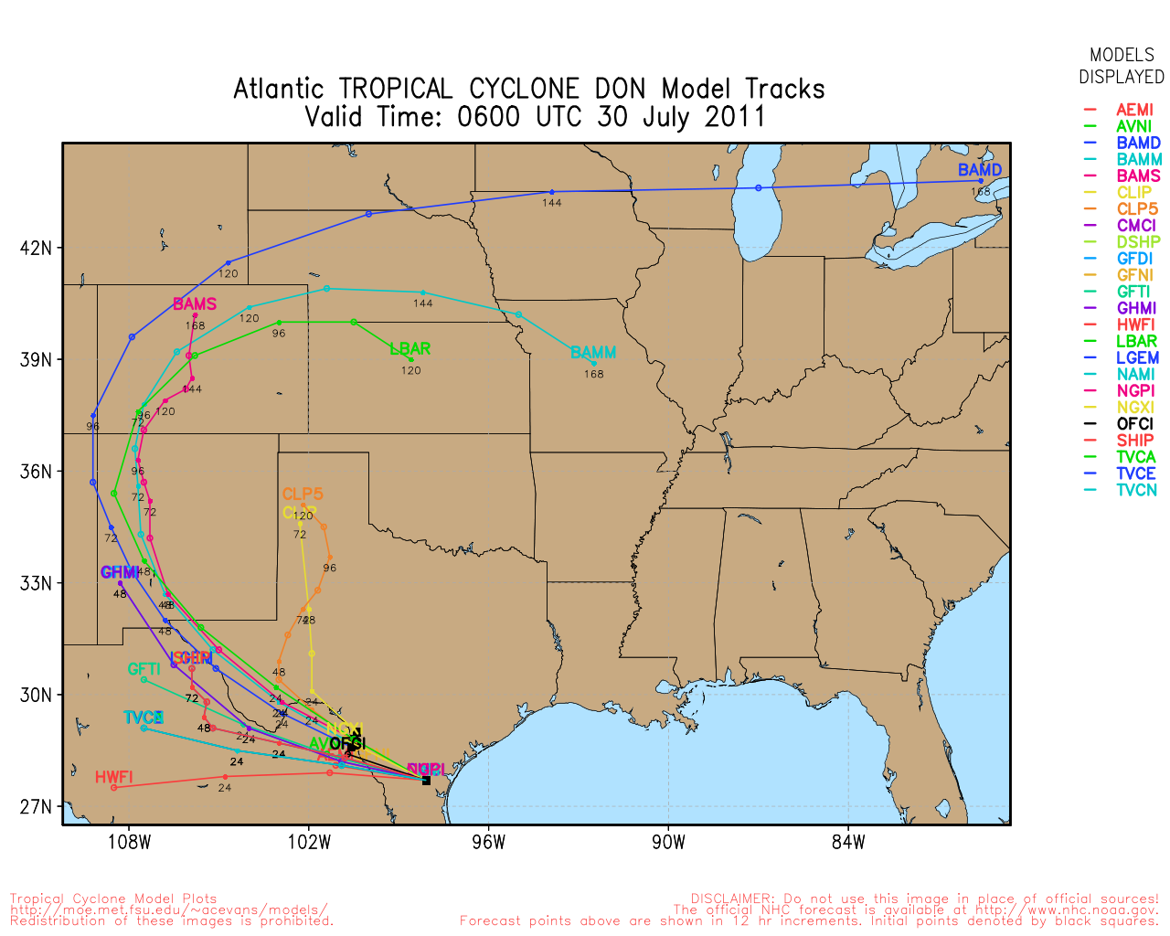
I would not recommend using the models to guide any particular future track at present, with the relatively small size of the system and lack of recon data, it appears models are all a bit too far north. Those in the Gulf coast from Corpus Christi/Matagorda southward into Northeastern Mexico are still in the highest probability for some affects with this system. If you are there, better review your preparation plans.
It is still too early to be any more specific than that because of the small size. Those further north into Western Louisiana will want to monitor it also, in case a weakness in the ridge forms.

For track, the single largest factor will be the ridge, any any weaknesses, it is expected that the ridge strengthens, keeping the system more westward than north. This lessens the chance for further north in the Gulf/Texas greatly. It is still worth watching for those until official advisories and forecasts on the system are made, however.
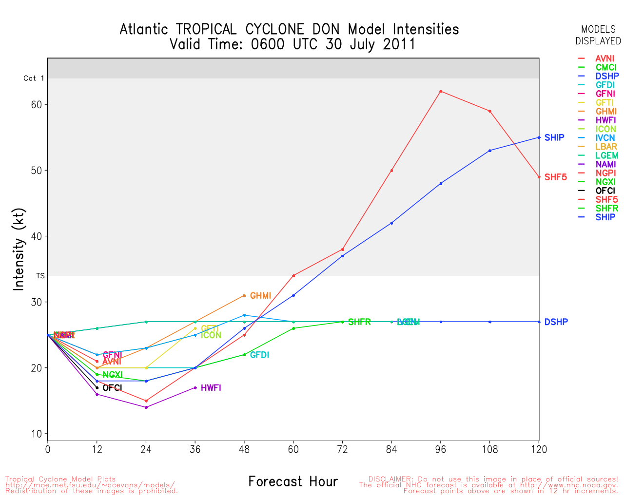
If it does develop, it will likely become Tropical Storm Don, and has a shot, with marginally favorable conditions, to become a hurricane. Given the usual methods, it could become a strong tropical storm, or Category 1/2 hurricane. There always exists the possibility in the Gulf for rapid intensification, and is a worry with smaller systems (They can rise and fall quickly) So it will need to be monitored closely for that, but that is not likely in this case since there is still a bit of dry air in the southern Gulf.
For now Cancun Yucatan will be dealing with some nasty weather and rain today, but nothing terrible. How much it organizes today will be limited on if it crosses the tip of the Yucatan or not.
Northeast Mexico, and the Texas coastline will want to monitor for official statements when/if this system forms. Based on current information, landfall timeline is Friday evening.
Cancun radar recording of 90L approach
Webcam Recording: Cancun Beach Palace roof looking north northeast along the beach.
7:45 PM EST Update 26 July 2011
The wave in the northwestern Caribbean continues to look better into the evening, but still lacks a defined low level circulation, if one to form it could develop within the next 48 hours. The National Hurricane Center gives the system a 40% chance for development, and barring a definite center forming overnight, it is unlikely to be upgraded until recon aircraft verify this during scheduled for a mission tomorrow, reach it.
Those in the extreme northern Yucatan in Mexco, and South Texas from Corpus Christi/Matagorda southward into Northeastern Mexico still need to continue to watch this system very closely, and those in the rest of the northwest Gulf should monitor it as well.
Original Update
90L may not be over, it is still worth watching.
With the wave dealing with land interaction the last few days, development chances were about nil (For the near term that the hurricane center keeps odds on, 48 hours). However, since the wave seems to be organizing in the Caribbean south of Cuba, and generally heading west, or slightly north of west, chances are rising again
Negative factors include some dry air, a short term upper level low to the west, and current lack of a defined low level circulation, but on the other hand shear is not really a factor, and will be less so as time goes on this week. The Upper level disturbance will likely dissipate before the end of the day, so that negative factor will likely disappear too.
As for the wave itself and the National Hurricane Center, during the day development chances will likely rise, and if the convection continues to persist like it is in the northwest Caribbean, it could even develop before approaches the Yucatan in the northwest Caribbean.

Which means, for those in the Yucatan (Around Cancun/Cozumel), Northeast Mexico, and south Texas (south of Corpus Christi), watch this system closely.
It will likely pass over the Yucatan briefly, and then into the southern Gulf, with northern Mexico the most likely place to eventually deal with it. It will bring quite a bit of rain areas it passes over. Most likely on Friday. Intensity is difficult to gauge with the Yucatan, warm water, dry air, and Northwestern Caribbean, so it could range from a nice rainstorm to a named system. Since the potential is there for that, those in the Yucatan, Northeast Mexico, and South Texas will want to watch this closely this week.
The zone in the Northwestern Caribbean is known for very favorable waters for developing systems, and this wave will be moving over part of that.
|
MikeC
Admin
Reged:
Posts: 4544
Loc: Orlando, FL
|
|
Bouy observations are starting to signal possible low level development, it's starting to seem like development chances are going up. Being in a prime location (northwest Caribbean) for development is a concern. The will likely raise chances at 2PM, and Hurricane Hunter aircraft are scheduled for tomorrow.
Those in northern Mexico and south Texas (Corpus Christi South) please watch this system closely for Friday.
How much it develops before it gets to the Yucatan may signal how much of a threat it could be to your area.
Tomorrow we'll probably turn on Cancun radar recording.
|
danielw
Moderator

Reged:
Posts: 3525
Loc: Hattiesburg,MS (31.3N 89.3W)
|
|
I see a ship report of WNW at 29mph, pressure 29.85in, near 20.1N/ 83.6W.
This position is in the SW Quadrant of the disturbance.
Winds are currently from the SE at 16mph at Punta Del Este, Isla De La Juventud, 21.5N/ 82.5W.
This would be the NE Quadrant.
|
doug
Weather Analyst
Reged:
Posts: 1006
Loc: parrish,fl
|
|
It has been my opinion that the lower level clouds have shown a cyclonic motion since yesterday along and near 20.0N and moving west. I just checked and the latest picture they have is focused on 20.0N 83W, for what ever that is worth. The Drorak loop also reflects that too.
--------------------
doug
|
danielw
Moderator
Reged:
Posts: 3525
Loc: Hattiesburg,MS (31.3N 89.3W)
|
|
I saw the same thing on the GHCC satellite site. Lower clouds are moving in a cyclonic motion. While the upper level high, thin cirrus are moving anticyclonic.
This would be somewhat favorable for development. I do think there is a low pressure trough line that extends to the south of the disturbance. Based on converging winds. This could be the lower tropical wave. I'm not an expert by any means.
Latest frame from Cuban radar.

Copyright © 1997-2011. INSMET ®
|
MikeC
Admin
Reged:
Posts: 4544
Loc: Orlando, FL
|
|
Based on a few emails I have to reiterate, this system has not developed, yet. And hype and speculation is not what we do here (with the exception of the lounge). Currently with the wave in the northwest Caribbean it is important for those that could be affected to watch, but there is nothing to get worked up over yet.
If you have done the usual hurricane preparations for the season (see www.onestorm.org for more on that) then there is not much to do but watch to see what will happen over the next few days. Especially with a system that has not developed as of yet.
Those in Texas dealing with drought conditions could use some rain, but not a dangerous system.
Those from Corpus/Matagorda Bay southward into northeastern Mexico should be watching this closely, and those in the rest of the Texas and Gulf coasts should monitor it as well, but there is nothing suggesting any action other than usual preparations at this time.
|
MikeC
Admin
Reged:
Posts: 4544
Loc: Orlando, FL
|
|
I went ahead and started the Cancun radar recording:
Cancun radar recording of 90L approach
|
danielw
Moderator
Reged:
Posts: 3525
Loc: Hattiesburg,MS (31.3N 89.3W)
|
|
Best web cam I can find, so far. This appears to be from the Cancun Omni Hotel roof looking NNE along the beach.

http://www.webcamcancun.com
Notice the lack of wave action in the Caribbean on the right and the Laguna Nichupte' on the left.
Same web camera 30 minutes later.

Edited by danielw (Wed Jul 27 2011 12:38 PM)
|
MikeC
Admin
Reged:
Posts: 4544
Loc: Orlando, FL
|
|
The 8AM Tropical Weather outlook picked up on a possible center trying to form on the Cancun Radar about 50 miles northeast of Cancun, MX. The recon plane is scheduled to go out at 11:30 AM this morning, so if it continues, first advisory is likely to come this afternoon, unless Cancun radar/Satellite evidence is strong enough to support it earlier (which is borderline).
Actually T numbers are up to 1.5, so there is a good chance that this system may start advisories at 11, before the plane gets there.
|
WesnWylie
Weather Guru
Reged:
Posts: 155
Loc:
|
|
Here is a really good visible satellite image of 90L heading into the Gulf of Mexico. It looks very good on satellite, even infrared. I believe it has taken, at least a temporary, movement toward the west-northwest/northwest. I think it will skim by the Yucatan. http://climate.cod.edu/data/satellite/2km/Gulf_Mexico/current/Gulf_Mexico.vis.gif
Edited by WesnWylie (Wed Jul 27 2011 12:40 PM)
|
MikeC
Admin
Reged:
Posts: 4544
Loc: Orlando, FL
|
|
Quote:
Best web cam I can find, so far. This appears to be from the Cancun Omni Hotel roof looking NNE along the beach.
I've got that recording now (currently on 3 minute intervals):
|
danielw
Moderator
Reged:
Posts: 3525
Loc: Hattiesburg,MS (31.3N 89.3W)
|
|
Quote:
Here is a really good visible satellite image of 90L heading into the Gulf of Mexico.
Nice shot! Notice the curved lines to the NW of the Yucatan Peninsula. That appears to be the leading edge of the Tropical Wave. Waiting on a few more frames to see what it's doing.
Or it's the beginning of a surface low with a mid level center displaced to the south. I'll go with the former for now.

|
danielw
Moderator
Reged:
Posts: 3525
Loc: Hattiesburg,MS (31.3N 89.3W)
|
|
I've got that recording now (currently on 3 minute intervals):
Mike that is really nice. It's Almost better than radar!
|
MikeC
Admin
Reged:
Posts: 4544
Loc: Orlando, FL
|
|
Quote:
I've got that recording now (currently on 3 minute intervals):
Mike that is really nice. It's Almost better than radar!
I just bumped it to the max I can do (1 minute intervals) while the apparent center is nearest to Cancun.
Also: It's the roof of the Beach Palace Cancun, which I updated to reflect
|
WesnWylie
Weather Guru
Reged:
Posts: 155
Loc:
|
|
I agree. I think the circulation to the NE of the Yucatan is the LLC. It appears to be moving toward the west-northwest. If this is the surface low, it has got some work to do to fill in the northern side of the developing system.
--------------------
2011 Season Forecast: 16/09/04
2011 Systems: 10/01/01
|
danielw
Moderator
Reged:
Posts: 3525
Loc: Hattiesburg,MS (31.3N 89.3W)
|
|
RECON scheduled to depart at 11:30 AM EDT this morning with arrival near 1:30 PM EDT.
CARCAH, National Hurricane Center, MIAMI, FL.
1030 AM EDT TUE 26 JULY 2011
SUBJECT: TROPICAL CYCLONE PLAN OF THE DAY (TCPOD)
VALID 27/1100Z TO 28/1100Z JULY 2011
TCPOD NUMBER.....11-056
I. ATLANTIC REQUIREMENTS
1. SUSPECT AREA (NEAR TIP OF YUCATAN)
FLIGHT ONE -- TEAL 70
A. 27/1800Z
B. AFXXX 01DDA INVEST
C. 27/1530Z
D. 22.0N 87.0W
E. 27/1730Z TO 27/2130Z
F. SFC TO 10,000 FT
2. OUTLOOK FOR SUCCEEDING DAY: BEGIN 6-HRLY FIXES
AT 28/1200Z NEAR 23.0N 91.5W IF SYSTEM DEVELOPS.
|
doug
Weather Analyst
Reged:
Posts: 1006
Loc: parrish,fl
|
|
Good call on the location of the developing circulation center. This is a very interseting set up, with a sharp trough pushing down over Florida to its northeast.. Some of the convective activity on the east of the system seems to be influenced by that , which will only serve to retard development of a larger system in the short term. I think all that and the ridge to the north are supposed to pull out a bit today and perhaps, if the center can remain over water, the system will pull together a bt more.
--------------------
doug
|
MikeC
Admin
Reged:
Posts: 4544
Loc: Orlando, FL
|
|
22.0N 86.6W is probably the best guess for a center right now, on the northern side of all the cloud cover.
it's probably good enough to upgrade now, but recon will verify it. If it is forming further north well into the straits, then it opens up a bit of speculation on future track.
|
Wingman51
Weather Guru

Reged:
Posts: 126
Loc: Orlando, FL
|
|
Fascinating to see the cloud direction shift and show some banding - - great photo progression
|
WesnWylie
Weather Guru
Reged:
Posts: 155
Loc:
|
|
The NWS in Houston/Galveston, TX stated in their AFD at 11:05 AM CDT that RECON was flying (more likely approaching) into 90L. Does anyone happen to know what are the max. sustained winds they are reporting?
--------------------
2011 Season Forecast: 16/09/04
2011 Systems: 10/01/01
|


 Threaded


