MikeC
Admin
Reged: Sun
Posts: 4543
Loc: Orlando, FL
|
|
<b>Update - Sunday, August 14, 5PM EDTb> <br />Based on Recon, upgraded TD7 to Tropical Storm Gert with sustained winds of 40 knots. Gert is listed as moving NNW, however past movement had been more WNW when convection was displaced from the low level center last night. Southwesterly upper level flow is still causing some shear over Gert and this flow is expected to increase over the next couple of days. Intermittent convective displacement is still possible which could cause a wobbling system track and fluctuations in intensity until the system structure improves. Since the current expectation is for Gert to pass near Bermuda on Monday afternoon, Tropical Storm Warnings have been issued for the Island.<br />ED<br /> Weather Conditions at Hamilton, Bermuda <br /><br /> Bermuda Weather Radar <br /><br /><b>11:30 PM EDT 13 August 2011 Updateb><br />Franklin has weakened and under cool SSTs of 25C the system has become . Invest 94L is now Tropical Depression 7 located about 360 miles SSE of Bermuda and a Tropical Storm Watch has been issued for Bermuda. TD7 is expected to intensify but the system has a large SAL area to the east and a lot of dry air to contend with so any intensification should be slow.<br /><br />Invest 92L is looking a lot better in terms of convection and organization this evening and 92L could create erratic movement for TD7 in the next couple of days. 92L will be moving into a less hostile upper air environment and also has a chance for additional intensification.<br /><br />Invest 93L in the east-central Atlantic, because of significant dry air to the north of the system, has been on a rapid decline and may not recover.<br />ED <br /><br /><br /><b>6:30 AM EDT 13 August 2011 Updateb><br />Tropical Storm Franklin has formed, from Tropical Depression Six in the middle of the Atlantic, moving North East. This system is no threat to land and is another named system this year that will likely fail to reach hurricane strength. <br /><br /> The story with the rest of the watched areas in the Atlantic remains basically unchanged.<br /><br /><b>5PM EDT 12 August 2011 Updateb><br />Invest 95L has been upgraded to Tropical Depression Six located over 250 miles to the north of Bermuda. The TD is moving to the east northeast and an east northeast to northeast movement should continue until the system merges with a frontal zone in a couple of days (or less). The system already exhibits some characteristics. Some minor additional development is possible and TD6 could become a minimal Tropical Storm later tonight or on Saturday.<br />ED<br /><br />The wave northeast of the Leewards (now tracked at 94L) is looking the best of the rest tonight and may well wind up being the next depression to develop. Luckily this appears like it too will recurve.<br /><br />In short, all except the easternmost wave (93L) looks to have very little chance of affecting land.<br /><br /><br /><b>7 AM EDT 12 August 2011 Updateb><br />The tropics continue to bubble today with 4 separate areas worth watching. A broad low area northeast of the Caribbean has "broke off" from the remnants of Emily and moved with the flow back south. This is very weak at the moment, but based on the time of year it has to be watched to see if something comes of it, it is not being tracked as an invest it this time. Of all the systems currently highlighted in the Atlantic, this may wind up being the most interesting and it should be watched closely to see if anything forms out of it, if it does it has a higher than usual chance to affect the Bahamas and possibly the coast. Thankfully it is the least likely to develop out of all the systems in the Hurricane Center's outlook.<br /><br /> 92L remains weak and by far most likely to recurve before reaching any land. <br /><br /> 93L, if it remains weak and in the shadow of 92L will likely continue westward, if it were develop and strengthen chances of it moving north and recurving are much greater. It too will have to be monitored, but it is still most likely to recurve at some point. (Although like yesterday, it's much too far out to be certain of it)<br /><br /> It is likely the latter half of August will be busy in the tropics, with a good number of storms, but few making it close enough to worry about. The most concerning systems will be the ones that form closer toward the US or off of old fronts or systems. <br /><br /><b>Original Updateb><br /> The Atlantic is starting to bubble up as it heads into mid August. Next week it appears there may be two systems being tracked, but thankfully the pattern is somewhat similar to last year in that most storms that form off Africa will likely recurve before reaching the US. There is some potential chance that the eastern Caribbean islands may see some affects from 93L (The second system), but it will have to be monitored.<br /><br /> Unlike last year, the North-Atlantic Oscillation (NAO) negative pattern that helped to prevent storms from reaching the coast isn't quite as strong, but still nothing like 2004/2005 that basically gave odds favoring landfall over not. This month, odds are most any system that develops off Africa will recurve, probably 70% chance that they do. Patterns can change, so the chance remains the systems can slip through. See the forecast lounge for more speculation on these systems.<br /> <br /> Outside of that, there is ex Emily, which is mainlining itself but conditions just aren't favorable for redevelopment.<br /> <br /> The area causing the rain in Florida lately is a trough of low pressure, if anything forms out of this it would be a very slow process, and would move east and away from the US.<br /><br /> In short, lots of potential things in the tropics, but nothing solid, next week will likely be much more active, but thankfully odds for any threat to the US that week is probably 1 in 10, and the eastern Caribbean islands 1 in 4. We'll monitor the trends, if either system were to buck the odds it would likely be the eastern most wave (93L)<br /><br />
92L (West Atlantic Wave) Event Related Links


SFWMD Model Plot (Animated Model Plot) SFWMD Hurricane Page
[https://flhurricane.com/floatanimator.php?year=2011&storm=9 Flhurricane Satellite Floater Animation of 92L
GOES Floater
Animated Model Plot of 92L
Clark Evans Track Model Plot of 92L
(Animated!) Model Plots in Google Earth - In Google Maps
Clark Evans Intensity Model Plot of 92L (Animated!)
Clark Evans Track Plot of 92L
Other Model Charts from Clark
Clark Evans Top 10 Analog Storms for 92L
More model runs on from RAL/Jonathan Vigh's page
NRL Info on 92L -- RAMMB Info
COD Atlantic Satellite View
<br /><br />
TS Gert Event Related Links


SFWMD Model Plot (Animated Model Plot) SFWMD Hurricane Page
[https://flhurricane.com/floatanimator.php?year=2011&storm=7 Flhurricane Satellite Floater Animation of TS Gert
GOES Floater
Animated Model Plot of TS Gert
Clark Evans Track Model Plot of TS Gert
(Animated!) Model Plots in Google Earth - In Google Maps
Clark Evans Intensity Model Plot of TS Gert (Animated!)
Clark Evans Track Plot of TS Gert
Other Model Charts from Clark
Clark Evans Top 10 Analog Storms for TS Gert
More model runs on from RAL/Jonathan Vigh's page
NRL Info on TS Gert -- RAMMB Info
COD Atlantic Satellite View
<br /><br /><br /> Long term Central Atantic wide area Water Vapor Satellite for Hurricane Season Peak flhurricane)<br /><br /> Long term West Atantic wide area Water Vapor Satellite for Hurricane Season Peak flhurricane)<br /><br />
Edited by Ed Dunham (Mon Aug 15 2011 12:01 AM)
|
MichaelA
Weather Analyst

Reged: Thu
Posts: 945
Loc: Pinellas Park, FL
|
|
Yes, lots of areas to watch for potential development this week. The wave train over Africa has set up rather nicely too. Coming into the meat of the season, things could get going rather quickly.<br /><br />EDIT: Seems the servers are down this morning.
--------------------
Michael
PWS
Edited by MichaelA (Fri Aug 12 2011 08:41 AM)
|
MichaelA
Weather Analyst
Reged: Thu
Posts: 945
Loc: Pinellas Park, FL
|
|
92L - looks like it is getting vertically stacked and developing.<br />93L - not much happening to that today.<br />94L - sheared and looking less and less likely to develop.<br />95L - sub-tropical?
--------------------
Michael
PWS
|
Rich B
British Meteorologist
Reged: Sat
Posts: 498
Loc: Gloucestershire, England, UK
|
|
95L will be classified at 5:00pm 
--------------------
Rich B
SkyWarn UK
|
Ed Dunham
Former Meteorologist & CFHC Forum Moderator (Ed Passed Away on May 14, 2017)
Reged: Sun
Posts: 2565
Loc: Melbourne, FL
|
|
Best Track:<br />AL, 06, 2011081218, , BEST, 0, 357N, 647W, 30, 1011, TD,<br /><br />The system looks very - at least more subtropical than tropical but we'll know in a few minutes.<br />ED
|
GuppieGrouper
Weather Master
Reged: Fri
Posts: 596
Loc: Polk County, Florida
|
|
Local Tampa news station is now reporting tropical storm number 5 has formed in the atlatnic, This would be the cable news 9 sttion on their website.
--------------------
God commands. Laymen guess. Scientists record.
|
MichaelA
Weather Analyst
Reged: Thu
Posts: 945
Loc: Pinellas Park, FL
|
|
Still looks to be subtropical to me. Did drop that term from use? Maybe they declared it due to shipping interests.
--------------------
Michael
PWS
|
Ed Dunham
Former Meteorologist & CFHC Forum Moderator (Ed Passed Away on May 14, 2017)
Reged: Sun
Posts: 2565
Loc: Melbourne, FL
|
|
That is not a correct report since Emily was the fifth TS of the season. As noted by the , Invest 95L has been upgraded to Tropical Depression Six.<br />ED
|
GuppieGrouper
Weather Master
Reged: Fri
Posts: 596
Loc: Polk County, Florida
|
|
You are correct it is number 6 and I am the poor reporter.
--------------------
God commands. Laymen guess. Scientists record.
|
MikeC
Admin
Reged: Sun
Posts: 4543
Loc: Orlando, FL
|
|
The tropics are boiling at this point, although only 93L has any chance of affecting anything. 94L was a bit of a surprise, but after looking at it (and models run on it), looks like it too will recurve. It may resemble last year, with lots of activity, but not much affecting land. 94L may wind up forming before the other two. And it's downright possible we'll have 3, maybe 4, tracked systems in the Atlantic at the same time.
|
Edski
Verified CFHC User

Reged: Tue
Posts: 18
Loc: Palm Harbor, Florida, USA
|
|
just the locations of the four systems seem to imply a strong Bermuda High, and a high chance of these systems recurving into the drink. 93 looks like the most menacing to avoid that fate, at least track wise. But it looks like it's suffering from dry air or Saharan dust right now, so I'm not to impressed right now with that system.
|
Random Chaos
Weather Analyst

Reged: Sat
Posts: 1024
Loc: Maryland
|
|
Looking at our four systems in the Atlantic (Franklin remnants, TD7, 92L SE of Bermuda, and 93L Mid-Atlantic):<br /><br /><b>Franklin remnants:b> Transitioned to an storm, well out to sea, being ripped apart, and not looking to ever effect land even as a remnant.<br /><br /><b>Tropical Depression 7:b> takes it passing near Bermuda, but strength wise it does not show any sign of becoming anything major. Most likely will pass Bermuda as a Tropical Storm, may strengthen a fraction more after that before transitioning to and following Franklin out to sea. No effect to anything but Bermuda, and that is minimal given it's lack of being a wind event.<br /><br /><b>92L:b> Actually looks almost better on IR than TD7 does. Somewhat surprised that is giving it only a 30% chance of development. It has already developed a very deep and is taking on a slight comma-like appearance. Vorticity models show plenty of spin around it, too. However, even if it should become our next Atlantic storm, like Franklin and TD7, it should be staying well out to sea with only a possible effect on Bermuda.<br /><br />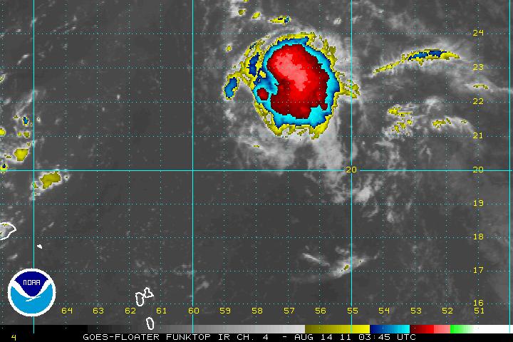 <br />(92L Funktop IR satellite view)<br /><br /><b>93L:b> This system is mid-atlantic, looks pretty weak at present. Not a lot of convection, fair amount of SAL to its north affecting it, but not in line with it's path. Models show little chance of development over the short term, but this system bears much more long term watching. Vorticity models show that the spin will stay intact for an extended period of time as it heads westward, and with no development, there is nothing to pull the system north. I would keep an eye on this system for possible development in a few days. To me, this system bears the most watching since it is the only one of the four systems that might not spin fish, should it develop.<br /><br /><br /><b>Ref:b><br />Cyclone Phase - http://moe.met.fsu.edu/cyclonephase/<br />GFS Models - http://moe.met.fsu.edu/tcgengifs/<br />SAL - http://tropic.ssec.wisc.edu/<br />IR / WV - http://www.ssd.noaa.gov/PS/TROP/trop-atl.html <br />(92L Funktop IR satellite view)<br /><br /><b>93L:b> This system is mid-atlantic, looks pretty weak at present. Not a lot of convection, fair amount of SAL to its north affecting it, but not in line with it's path. Models show little chance of development over the short term, but this system bears much more long term watching. Vorticity models show that the spin will stay intact for an extended period of time as it heads westward, and with no development, there is nothing to pull the system north. I would keep an eye on this system for possible development in a few days. To me, this system bears the most watching since it is the only one of the four systems that might not spin fish, should it develop.<br /><br /><br /><b>Ref:b><br />Cyclone Phase - http://moe.met.fsu.edu/cyclonephase/<br />GFS Models - http://moe.met.fsu.edu/tcgengifs/<br />SAL - http://tropic.ssec.wisc.edu/<br />IR / WV - http://www.ssd.noaa.gov/PS/TROP/trop-atl.html
Edited by Random Chaos (Sun Aug 14 2011 12:44 AM)
|
Random Chaos
Weather Analyst
Reged: Sat
Posts: 1024
Loc: Maryland
|
|
Amazing what a few hours does. 92L has completely collapsed. Not much chance of it doing anything now, in my opinion.
|
ShanaTX
Storm Tracker
Reged: Mon
Posts: 226
Loc: Texas
|
|
TD 7 is now TS Gert<br /><br />I was really hopin Invest 93 would hold together longer.
|
Ed Dunham
Former Meteorologist & CFHC Forum Moderator (Ed Passed Away on May 14, 2017)
Reged: Sun
Posts: 2565
Loc: Melbourne, FL
|
|
At 15/03Z, Gert continues moving generally north toward Bermuda as a 40knot Tropical Storm. On the current track forecast the cyclone would pass a little to the east of Bermuda on Monday, however, any expansion or slight shift to the left would bring stronger winds over the Island.<br /><br />Invest 92L seems to be getting absorbed by Gert's circulation and its becoming difficult to recognize 92L as a separate system.<br /><br />I'm not quite sure that I understand the reason for this one, but there is actually yet another system in the north Atlantic - newly minted Invest 96L which was located at 36.7N 63.8W at 14/18Z. It is moving rapidly to the north and was close to 39N at 15/03Z. Its a small system with a circulation and convection displaced to the east of the center. It will soon get absorbed by a frontal system to its west.<br />ED
|


 Threaded


