MikeC
Admin
Reged: Sun
Posts: 4543
Loc: Orlando, FL
|
|
There are two systems that may develop before or more likely during the weekend. One is a low still east of the Bahamas, that right now, is heading generally west northwest, and another just west of the Florida keys that still is heading generally west in the Gulf.
Both systems have potential for development
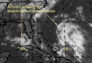
Development Potential scale for System East of Bahamas (aka 99L)
Code:
forget it) 0 1 2 3 4 5 6 7 8 9 10 (sure thing)


          [----------------*-----]
West of Florida Keys (aka 90L)
Code:
forget it) 0 1 2 3 4 5 6 7 8 9 10 (sure thing)


          [---------*------------]
Yes the tropics are now heating up. Both of these systems need to be watched. Since they have not developed into depressions or named storms yet, we'll have to rely on persistence to keep track. They are both are in very interesting positions and both do have the potential to impact land in some way down the road, but this is much too early to call as to what form or strength now. Right now, I don't expect too much from either.
Site Note: Popups now fixed for Safari, Mozilla Firefox, etc browser users. As well and National Weather Service Area Forecast Discussions that may reference either storm of interest now are listed at the top.
General Links
Current Aircraft Recon Info
NRL Monterey Marine Meteorology Division Forecast Track of Active Systems (Good Forecast Track Graphic and Satellite Photos)
Check the Storm Forum from time to time for comments on any new developing system.
Follow worldwide SST evolution here:
Global SST Animation
NASA GHCC Interactive Satellite images at:
North Atlantic Visible (Daytime Only), Infrared, Water Vapor
Some forecast models:
NGM, AVN, MRF, ETA ECMWF
AVN, , , JMA, , UKMET
DoD Weather Models (NOGAPS, AVN, MRF)
Multi-model plots from WREL
Other commentary at Mike Anderson's East Coast Tropical Weather Center, Independentwx.com, Robert Lightbown/Crown Weather Tropical Update Accuweather's Joe Bastardi (now subcriber only unfortunately), Hurricane Alley North Atlantic Page, Cyclomax (Rich B.), Hurricane City , mpittweather , Gary Gray's Millennium Weather, Barometer Bob's Hurricane Hollow, Snonut,
Even more on the links page.
|
James88
Weather Master

Reged: Tue
Posts: 576
Loc: Gloucestershire, England, UK
|
|
99L is probably the best looking system we've had yet this season! It would be extremely surprising (not to mention disappointing) if we didn't get at least a TD out of it.
|
Allison
Weather Guru

Reged: Tue
Posts: 134
Loc: Laredo, Texas
|
|
Yikes! And I'm headed to Florida for the weekend!
Allison
(umbrella in tow)
|
javlin
Weather Master
Reged: Wed
Posts: 410
Loc: Biloxi,MS
|
|
The 99L is the more impressive of the two systems.The dry air on the W side seems to be getting choked off some now.The GOM system will take a little longer to develop because some of the shear that 99L is appling to it.The distance between the two is not much maybe 600>800 miles.The 90L needs to move some for development to occur.The GC area is forecast for showers later today because of a regressing front.This front goes up the E coast this should impact the systems to W more so later this evening and tomorrow.All in all the 99L looks good togo for development.It should be an interesting weekend.
|
rmbjoe1954
Weather Master

Reged: Tue
Posts: 427
Loc: Port Saint Lucie, Florida, USA
|
|
The sat shows 99L heading NW; perhaps it's back on track to the Carolinas.
--------------------
________2024 Forecast: 28/14/8________
There is little chance that meteorologists can solve the mysteries of weather until they gain an understanding of the mutual attraction of rain and weekends. ~Arnot Sheppard
|
Old Sailor
Storm Tracker

Reged: Mon
Posts: 293
Loc: Florida
|
|
I think if 90L keep the thunder storms ovenight then going to see a TS in mid of GOM ,if not then just a low or at best TD. 99L not sure about that one just maybe a rain making unless it there is a surface low, wait and see game.....
Dave 3 days shy of 75 yrs...
|
LI Phil
User

Reged: Fri
Posts: 2637
Loc: Long Island (40.7N 73.6W)
|
|
Anybody know why we haven't gotten any readings for either 99L or 90L?
--------------------
2005 Forecast: 14/7/4
BUCKLE UP!
"If your topic ain't tropic, your post will be toast"
|
bobbi
Unregistered
|
|
Just a few observations from Miami. The rain stopped. There are blue skies overhead and a strong breeze out of the East. This is a sudden change, btw.. and not the heavy torrential rains that were promised for today.
On Invest site...IR shows no reds in either system though. Would like to see a little more intensity before deciding this is a sure thing.
Does have that look though.. it is singing to me.
|
HanKFranK
User

Reged: Mon
Posts: 1841
Loc: Graniteville, SC
|
|
circumstances got me off work today early. more to look at than i'd expected. going to be working the treestands and property at my grandpa's tomorrow so probably won't be around WHEN THE TIME COMES, but i'll try to predict upcoming events now.
the eastpac has spit out system number four (blas, celia, darby, 6E) in the last two weeks, and now the atlantic has finally responded in kind with the upstream development. over in the westpac the pattern drove a typhoon on an unusual northwest track near japan, which teleconnects to a hit on the s.e. coast. the precursors were there, the gate is down.. and today we have two invests.
99L (invest 10) is impressive and probably well suited to develop quickly once a surface low develops. convection is persisting and refiring in the diffluent zone east of the upper trough near the bahamas, and has the potential to support a healthy tropical cyclone. even though 90L (invest 11) has a better surface setup, 99L is rapidly catching up. already the low cloud movements are beginning to hairpin near the convection, and i'm sure that there have been some pressure falls. i believe a tropical depression will form there tomorrow morning and be alex by evening. haven't had a great view of the models, but feel it's overall movement will be slowly nw to the s.e. coast between melbourne and georgetown. it should will probably reach the s.e. coast sunday or monday (should slow down as it nears 80w). a lot can happen between now and then, or nothing can happen, but there is potential for an interesting time.
for 90L, development should be slower. if 99L cranks quickly it will likely be inhibited. initial movement for 90L should be erraticly westward and slow.. if it develops it will likely come north between the big bend and the ms/al line middle of next week.
it is very likely we'll have a named storm by the weekend. it is also likely that a tropical system will landfall in the southeastern u.s. by the middle of next week. if both develop they'll be close enough to affect one another, fujiwhara or otherwise.
we've had a few false alarms early this season.. looks like the real thing this time. get psyched.
HF 1912z29july
|
Old Sailor
Storm Tracker
Reged: Mon
Posts: 293
Loc: Florida
|
|
readings for either 99L or 90L From what I can see both too weak for a reading, everybody seems to be jumping on 99L, my gut tells me 90L maybe the one to watch. again it's a wait and see thing.
Dave
|
SirCane
Storm Tracker

Reged: Tue
Posts: 249
Loc: Pensacola, FL
|
|
It was only a matter of time before something popped up! I wouldn't be surprised to see a southeast double wammy come next week!
--------------------
Direct Hits:
Hurricane Erin (1995) 100 mph
Hurricane Opal (1995) 115 mph
Hurricane Ivan (2004) 130 mph
Hurricane Dennis (2005) 120 mph
http://www.hardcoreweather.com
|
LI Phil
User
Reged: Fri
Posts: 2637
Loc: Long Island (40.7N 73.6W)
|
|
Looking at the latest IR loop I gotta agree with Bobbi & Old Sailor that neither wave is looking all that great at the minute. As far as 99L, though, the faster it develops, the more chance it gets shredded. We need to be patient (as does the wave) with that one. If it becomes Alex, it probably won't be until (Ed's guess) Saturday. 90L may actually be the better candidate for development at present. Either way, though, somebody's gonna see a boatload of tropical moisture from it.
Lets see what the 5:30 says. So far, they've still got the two planes going in tomorrow.
--------------------
2005 Forecast: 14/7/4
BUCKLE UP!
"If your topic ain't tropic, your post will be toast"
|
Cycloneye
Storm Tracker
Reged: Thu
Posts: 373
Loc: Puerto Rico
|
|
TROPICAL DEPRESSION INVEST (AL902004) ON 20040729 1800 UTC
...00 HRS... ...12 HRS... ...24 HRS... ...36 HRS...
040729 1800 040730 0600 040730 1800 040731 0600
LAT LON LAT LON LAT LON LAT LON
BAMD 25.5N 83.4W 24.7N 84.8W 24.2N 86.4W 24.1N 88.0W
BAMM 25.5N 83.4W 25.3N 84.5W 25.1N 85.9W 25.3N 87.3W
A98E 25.5N 83.4W 25.5N 84.3W 25.1N 85.4W 24.2N 86.6W
LBAR 25.5N 83.4W 25.2N 84.4W 25.3N 85.8W 25.9N 87.4W
SHIP 25KTS 30KTS 37KTS 44KTS
DSHP 25KTS 30KTS 37KTS 44KTS
...48 HRS... ...72 HRS... ...96 HRS... ..120 HRS...
040731 1800 040801 1800 040802 1800 040803 1800
LAT LON LAT LON LAT LON LAT LON
BAMD 24.3N 89.8W 24.7N 92.9W 24.4N 95.1W 23.6N 97.8W
BAMM 25.5N 88.7W 26.3N 91.1W 26.5N 92.5W 26.5N 93.8W
A98E 23.7N 87.7W 22.4N 89.1W 21.3N 90.3W 21.0N 91.5W
LBAR 26.7N 88.9W 28.6N 90.7W 30.1N 91.2W 31.4N 91.8W
SHIP 53KTS 65KTS 69KTS 71KTS
DSHP 53KTS 65KTS 69KTS 71KTS
...INITIAL CONDITIONS...
LATCUR = 25.5N LONCUR = 83.4W DIRCUR = 270DEG SPDCUR = 5KT
LATM12 = 25.5N LONM12 = 82.3W DIRM12 = 270DEG SPDM12 = 6KT
LATM24 = 25.5N LONM24 = 80.7W
WNDCUR = 25KT RMAXWD = 20NM WNDM12 = 20KT
CENPRS = 1011MB OUTPRS = 1014MB OUTRAD = 150NM SDEPTH = D
RD34NE = 0NM RD34SE = 0NM RD34SW = 0NM RD34NW = 0NM
Dont take this for granted because until the GOM system develops better those plots wont be good.
--------------------
My 2004 hurricane season forecast=13/8/3
|
James88
Weather Master
Reged: Tue
Posts: 576
Loc: Gloucestershire, England, UK
|
|
Well, Bobbi - it looks as though there are a few specs of red beginning to appear on infrared imagery. Maybe this is the increase in intensity that you spoke about. Now that the Storm Floater is over 99L we can get a much better look at it. 90L is also an interesting system though. Either system could go.
|
James88
Weather Master
Reged: Tue
Posts: 576
Loc: Gloucestershire, England, UK
|
|
Does anyone have a link to weather buoys in the vicinity of 99L and 90L?
|
caneman
Unregistered
|
|
Here ya go James.
http://www.ndbc.noaa.gov/Maps/Florida.shtml
And while you're at it take a look at this buouy. A pretty good drop.
http://www.ndbc.noaa.gov/station_page.phtml?station=DRYF1
Whoa and another.
http://www.ndbc.noaa.gov/station_page.phtml?station=42003
|
Old Sailor
Storm Tracker
Reged: Mon
Posts: 293
Loc: Florida
|
|
Here you go James, this should help you.
http://www.srh.noaa.gov/sju/caribm.html,
Dave
|
James88
Weather Master
Reged: Tue
Posts: 576
Loc: Gloucestershire, England, UK
|
|
Thanks a lot, Caneman! 
And thanks Old Sailor! Have a great birthday this week!
Edited by James88 (Thu Jul 29 2004 04:24 PM)
|
bobbi
Unregistered
|
|
They are falling throughout the straits and area to the west of Key West.. note tho that the winds are low as well.
Think some ingredient has not shown its face yet, if you ask me.
|
red dots
Unregistered
|
|
one. small. is it at the surface tho?
notice most of the convention is not over the "center"
only red i saw in the other invest was over Havana..
|


 Threaded


