HanKFranK
User

Reged: Mon
Posts: 1841
Loc: Graniteville, SC
|
|
Alex is slowly getting more organized. The center is still fairly broad and mesoscale vortexes (short-lived mini-centers) can be seen whipping around the periphery of the sheared feature east of the Georgia coastline. Alex is currently hanging out on a limb of the atlantic ridge, a narrow height axis is oriented Sw-Ne to the west and north of the system. Some outflow aloft is apparent with Alex as well, and it is making a bulge on the ridge keeping the storm stuck off Georgia today.
When the storm begins to move it will cross under and possibly travel along this narrow ridge and find favorable conditions for strengthening. The SHIPS intensity model is calling for more strengthening than the official forecast.
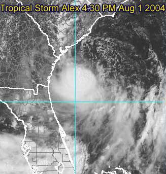
Afternoon visible of Alex with broad center partially exposed
The National Hurricane Center track carries Alex north and northeastward just off the coast of South Carolina, over Cape Fear and Carteret County, North Carolina, and then very close to Cape Hatteras.
Any minor deviation from this path could either result in the storm never making landfall, or a track over the coastal counties of the Carolinas. Specifically, deviation to the left would result in tropical storm conditions outside of the current warning area, so people in the watch area and perhaps as far down the coast as Savannah should keep this in mind.
Alex information:
Event Related Links
Charleston, SC Long Range Radar
Jacksonville, FL Long Range Radar
Various forecast tracks from earlier model runs, Wunderground.com
General Links
Current Aircraft Recon Info
NRL Monterey Marine Meteorology Division Forecast Track of Active Systems (Good Forecast Track Graphic and Satellite Photos)
Check the Storm Forum from time to time for comments on any new developing system.
Follow worldwide SST evolution here:
Global SST Animation
NASA GHCC Interactive Satellite images at:
North Atlantic Visible (Daytime Only), Infrared, Water Vapor
Some forecast models:
NGM, AVN, MRF, ETA ECMWF
AVN, , , JMA, , UKMET
DoD Weather Models (NOGAPS, AVN, MRF)
Multi-model plots from WREL
Other commentary at Mike Anderson's East Coast Tropical Weather Center, Independentwx.com, Robert Lightbown/Crown Weather Tropical Update Accuweather's Joe Bastardi (now subcriber only unfortunately), Hurricane Alley North Atlantic Page, Cyclomax (Rich B.), Hurricane City , mpittweather , Gary Gray's Millennium Weather, Barometer Bob's Hurricane Hollow, Snonut,
Even more on the links page.
HF 1956z01august
Edited by HanKFranK (Sun Aug 01 2004 04:59 PM)
|
LI Phil
User

Reged: Fri
Posts: 2637
Loc: Long Island (40.7N 73.6W)
|
|
Congrats on producing the new forum, HF 
Great commentary.
I posted it on the last thread, but not sure anyone saw it. SHIPS model has Alex at 73 mph in 48 hours and 74 mph in 72 hours. Of course, by that time, Alex will be heading across the pond towards James & Rich.
SHIPS also takes Alex to 60 mph in 24 hours, so folks from Hattaras south to JAX should probably keep a watchful eye on this one. Like some others on this board, I'm not totally convinced of the track across the NC barrier islands, although all the models I've seen take it either that way or even further east.
91L also bears watching down the road. Right now it's chugging along on it's merry way, occasionally flaring up and then dying down.
90L has been taken down by , but anything in the gulf bathtub needs to be monitored.
Cheers,
LI Phil
--------------------
2005 Forecast: 14/7/4
BUCKLE UP!
"If your topic ain't tropic, your post will be toast"
Edited by LI Phil (Sun Aug 01 2004 07:27 PM)
|
HanKFranK
User
Reged: Mon
Posts: 1841
Loc: Graniteville, SC
|
|
well, it's a start. at least the visible still came up pretty. sorry about the URL failure folks, ed warned me it was tricky. i'll update the thread in a while and get them working then. they're A-ok on the older threads.
HF 2010z01august
|
Carl
Unregistered
|
|
anyone else notice the spin that seems to be developing in the central GOM around 26/89?
|
James88
Weather Master

Reged: Tue
Posts: 576
Loc: Gloucestershire, England, UK
|
|
The latest advisory puts Alex up to 45kts in 24 hours and maintains that throughout the forecast period. While it is no longer predicted to make landfall, it is expected to come very close to the coastline, so tropical storm warnings are still in force. The tropical storm warning is extended southwards and now extends from South Santee River SC to Cape Hatteras NC - including the Pamlico Sound.
|
Robert
Weather Analyst

Reged: Sat
Posts: 364
Loc: Southeast, FL
|
|
Alex wont strengthen much unless one of its three to possibly 4 centers take over. And that will not happen untill its center gets under the deep convection displaced to the Southwest.
|
Robert
Weather Analyst
Reged: Sat
Posts: 364
Loc: Southeast, FL
|
|
For those who have forgotten this is what a healthy Tropical Storm looks like
Tropical Strom
Added by ED:
Use the URL capability to put a link to an image in your posts - do not put large images in your post - it uses too much bandwidth. Small images (or a downsized image) are okay. Remember, if a site Administrator or Moderator modifies your post it is for a good reason - so please keep this in mind before you re-edit what they have corrected.
Thanks.
Ed Dunham
CFHC Administrator
Edited by Ed Dunham (Mon Aug 02 2004 01:27 AM)
|
Rich B
British Meteorologist
Reged: Sat
Posts: 498
Loc: Gloucestershire, England, UK
|
|
Well it seems like Alex hasnt really wanted to play ball today. Looking weak and unorganised at first he strengthened to a 40 mph Tropical Storm. He has been going to move to the north or north-northeast; but doesnt seem to have quite got the message yet as he isnt going anywhere fast. And now it looks like he might strengthen some more.
The satellite appearance is improving, and there is no some evidence of a little outflow extending northeast from the area of convection. As the say this indicates upper-level conditions are becoming more favourable, but interestingly the intensity forecast call for him to strengthen to 45 knots, and no higher. I think it may be that Alex could strengthen a little more than forecast, as long as he keeps off the coast.
--------------------
Rich B
SkyWarn UK
Edited by Rich B (Sun Aug 01 2004 05:33 PM)
|
James88
Weather Master
Reged: Tue
Posts: 576
Loc: Gloucestershire, England, UK
|
|
I agree Rich. As long as Alex stays far enough away from the coast, I think he could reach 50kts or so (possibly a little more). Being over the Gulf Stream with some favourable conditions forecasted within the next 24 hours could work in Alex's favour.
|
LI Phil
User
Reged: Fri
Posts: 2637
Loc: Long Island (40.7N 73.6W)
|
|
Actually, ever since Alex got named, he hasn't behaved as the has thought. My gut (and that's all it is) feeling is that he hangs out (stationary) for the time being, before beginning a slow north, then northeast jog. I think the center stays off the coast (just barely), and convection really begins to wrap around the east and northeast quadrants. Folks along the SC and NC beaches will be in for quite a bit of nasty weather.
Cantore is in Wrightsville Beach, NC, so you have to figure the storm will eventually get fairly close to him in the next 24-36 hours. Visibles from there today showed pretty heavy surf and beautiful sunshine, but that's going to change in short order.
As far as intensity, I think this is somewhere in between SHIPS (60 mph @ 24 Hours) and (40 mph); I'll say Alex gets up to 50+ mph in the next 24 hours or so.
Remember, he got named before thought he would (although it should have been fairly apparent he'd get named sooner--hey, if I can see that coming, then they sure should have  ). ).
A'ight [tm by HF], that's my take. Probably be wrong as usual but Alex aint misbehavin'.
--------------------
2005 Forecast: 14/7/4
BUCKLE UP!
"If your topic ain't tropic, your post will be toast"
|
James88
Weather Master
Reged: Tue
Posts: 576
Loc: Gloucestershire, England, UK
|
|
Looks like there is some deeper convection building up nearer to the centre of Alex. Maybe he'll be up to 40kts at the next advisory.
|
HanKFranK
User
Reged: Mon
Posts: 1841
Loc: Graniteville, SC
|
|
robert is a very astute fellow. what he can't seem to spell out he uses pictures to convey, so now we all know what a mature tropical storm looks like. i'm sure nobody could tell the difference between alex and a tropical storm in optimal strengthening conditions. mike took the oversize image down, but robert is really intent on letting us see it anyway. so, thank you, robert. t.s. lurks above, yet again.
maybe mike will nix it once more, but i'm personally going to leave it up as an example of what not to do.
addon: it was gone again before i finished my post. but you can always click the link. it's a really nice false-color shot.
HF 2206z01august
Edited by HanKFranK (Sun Aug 01 2004 06:09 PM)
|
LI Phil
User
Reged: Fri
Posts: 2637
Loc: Long Island (40.7N 73.6W)
|
|
I'm going to second HF's message, and thank you Ed, for removing the oversized image which screwed up the boards.
Robert,
if you're out there. I'M THE ONE who PMed Mike and asked him to scale down (he actually turned it into a URL) your image...because I would have had to delete it.
Well Mike did that and you still saw fit to put it back up. I've also alerted HF and Ed to your behavior and they took action as well.
Pull another stunt like this and it will be your last post, I can assure you of that. That was completely uncalled for behavior and it will not be tolerated on these boards. This was not the first instance or an isolated event. You have been given fair warning.
LI Phil
--------------------
2005 Forecast: 14/7/4
BUCKLE UP!
"If your topic ain't tropic, your post will be toast"
|
HanKFranK
User
Reged: Mon
Posts: 1841
Loc: Graniteville, SC
|
|
were alex a bit stronger i'd try and take tomorrow off and head down to georgetown or myrtle beach in the morning. the structure is so iffy there's no guarantee there'd be anything other than occasional showers and a stiff breeze. a seabreeze front/feeder band is onshore in the low country right now and obs down there aren't showing more than typical afternoon summer weather. the outer banks have a better shot at seeing some squalls.
HF 2215z01august
|
James88
Weather Master
Reged: Tue
Posts: 576
Loc: Gloucestershire, England, UK
|
|
Look at the impressive circular appearance Alex has now taken on. Perhaps signs of weakening shear - but could this also be a sign of the centre reforming? Whatever the case, Alex looks like he is on the brink of some good intensification, and the longer he is over water, the more serious the situation could get.
Edited by James88 (Sun Aug 01 2004 06:16 PM)
|
LoisCane
Veteran Storm Chaser

Reged: Fri
Posts: 1236
Loc: South Florida
|
|
If Alex had the color..storms that we had in Miami just now sitting over his little heart.. he'd be looking like that real nice well developed tropical storm.
One of the strongest electrical storms I've seen down here in a long, long while. All of Florida was lit up in darker shades of red than anything in Alex.
Suppose if some of the warm moisture can wrap into him he could intensify nicely.
Storm is coming back down here.
Seems like everyone on the East Coast got rain today except those nice beach shots on CNN and where they are explaining that even tho its not raining they do have rip currents.
Yup.. Alex is a brat all right.
--------------------
http://hurricaneharbor.blogspot.com/
|
Frank P
Veteran Storm Chaser
Reged: Mon
Posts: 1299
|
|
Been watching the GOM for the past two days. Watching the vis sat loop during the past hours sure appears to hint of a developing mid to upper level circulation at ~26.2n and ~89.0w, with convection on the rise off the east side of the center... several others have mentioned this possiblility on this board and on storm2k, but I've only been able to discern this rotating feature during the past hour or so... area buoy data, nor vis sat pixs do not support any low level circulation in this area however
|
teal61
Weather Hobbyist
Reged: Sun
Posts: 61
Loc: Spring, TX (30.1N 95.5W)
|
|
Frank P, it's good to hear from ya. I had to go to the NASA GHCC site to find it, but I think I see what you are talking about. Due east of Brownsville and due south of the mouth of the Mississippi you can pick out some of the lower cloud elements moving from west to east. I think there might be a trough extending from Alex across Florida through the central GOM and I wouldn't be surprised at all to see something close off down there. Too much activity in the Gulf to ignore. What's left of 90L is in the western GOM southeast of Brownsville and I don't think it will be a factor at this point.
|
Anonymous
Unregistered
|
|
been watchin vis....and looks like storms are still blowing up this evening. Doesn't seem like Alex wants to head to the carloina shores anytime soon.....the last few hours of sat shots looking real good..... could the reforming center be moving little due-east of north?
pressure at Station 41008 - GRAYS REEF - 40 NM Southeast of Savannah, GA....keeps falling all day and this evening.....
i wish the they could get the SABSOON Tower Data back online..... we get some good readings of the storm.......REAL-TIME data too......(not to mention close to "center"of alex)
http://www.skio.peachnet.edu/research/sabsoon/tower.php
|
Tropics Guy
Storm Tracker

Reged: Thu
Posts: 252
Loc: Miami, Florida
|
|
Well, been away from the computer for awhile, and nice to see that our season has finally started with Alex, tonight it looks , at least fron the sat pics that he may be strengthening.
A trailing trough indirectly associated with alex brought severe storms here in the south fla area today, and more expected tomorrow.
91L in the atlantic is still holding on, and seems like convection may be on the increase, haven't checked the long-range models yet to see if it'll make it to the windwards and go into the Carib or further north towards the leeward islands and brush by the northern islands., in any case that is still a few days away, if in fact it holds together.
Oh yea, wanted to say congrats to HankFrank for becoming a moderator on this site, well deserved indeed!, and happy birthday old sailor.

TG
--------------------
Tropical Cyclones: "Mother nature's heat transfer machines"
|


 Threaded


