MikeC
Admin
Reged: Sun
Posts: 4543
Loc: Orlando, FL
|
|
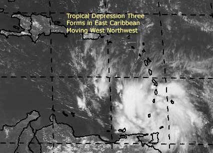
The third tropicla depression of the year has formed in the far eastern Caribbean. We are watching it closely, and the current forecast track moves it into the Western Caribbean, including getting very close to Jamaica. It's forecast to become a hurricane in 72 hours or so.
Right now, that and the influence of former TD#2 in the gulf it'll be an interesting next few days
More to come.
Event Related Links
Martinique Radar
The Caribbean Hurricane Page - updates from the islands
Caribbean Island Weather Reports
General Links
Current Aircraft Recon Info
NRL Monterey Marine Meteorology Division Forecast Track of Active Systems (Good Forecast Track Graphic and Satellite Photos)
Check the Storm Forum from time to time for comments on any new developing system.
Follow worldwide SST evolution here:
Global SST Animation
NASA GHCC Interactive Satellite images at:
North Atlantic Visible (Daytime Only), Infrared, Water Vapor
LSU Sat images
Some forecast models:
NGM, AVN, MRF, ETA ECMWF
AVN, , , JMA, , UKMET
DoD Weather Models (NOGAPS, AVN, MRF)
Multi-model plots from WREL
Other commentary at Independentwx.com, Robert Lightbown/Crown Weather Tropical Update Accuweather's Joe Bastardi (now subcriber only unfortunately), Hurricane Alley North Atlantic Page, Cyclomax (Rich B.), Hurricane City , mpittweather , Gary Gray's Millennium Weather, storm2k, Barometer Bob's Hurricane Hollow, Snonut,
Even more on the links page.
|
LI Phil
User

Reged: Fri
Posts: 2637
Loc: Long Island (40.7N 73.6W)
|
|
Thanks for the new thread Mike! 
--------------------
2005 Forecast: 14/7/4
BUCKLE UP!
"If your topic ain't tropic, your post will be toast"
|
Hardcore
Unregistered
|
|

This one has more potential than the gulf system  So will this be Bonnie or Charlie ? So will this be Bonnie or Charlie ?
http://www.hardcoreweather.com
|
BugsBunny
Weather Watcher

Reged: Thu
Posts: 42
Loc: Florida
|
|
This will likely be Bonnie in 24 hours or less
the system in teh gulf should make it up to TD2 again later today, but will not become a storm
--------------------
forecast: 17/14/9/5
to date: 3/3/2/1
|
Anonymous
Unregistered
|
|
I agree with that. Why is everyone posting on the other boards that the gulf storm will be anouther Opal ?
http://www.hardcoreweather.com
|
LI Phil
User
Reged: Fri
Posts: 2637
Loc: Long Island (40.7N 73.6W)
|
|
scottsvb posted this on the previous thread, but it has some good commentary, so I'll repost it here...
TD 3 as everyone knows has formed today and is the major feature of the moment. TD3 actually has a LLC for the last 2 days but was part of the and didnt have the TS around or near the center. Finally today after the system got better organized and land obs this was upgraded. Pressure is still high but will slowly fall as it has very good enviroment around it. The pressures are generally high for this time of year in the eastern carribean sea. I expect the system to become better organized slowly and become a T.S in next day or so. When the system gets w of 70W i expect it to begin a more generaly strengthning faze as it will slow down some and surrounding pressures will be slightly lower then the 1014-15 in the islands (outside of TD3). I expect this to become a hurricane after it passes Jamaica on Thursday. Probably the evening. Another trough will be pushing into the eastern U.S. after 96hours from now. How far down it digs and the placement of where the current TD3 will be will determine the weekend movement of the hurricane. Best scenerio right now is it to move into the se Gulf and up florida or across. Some think it might stay alittle more s and move into the Yucitan chaneel drift and move w towards Texas or Mexico when the trough moves out later Monday into Tuesday. Looks like Friday and Saturday we will have a idea. System should gradually get stronger till the weekend.
System in the Southern gulf is a tight compact system. Had great radar from Mexico last night into today. The system could be classified when recon checks this out today and might find TS winds. Pressures are high though and this should get absorbed into the eastern U.S trough and move NE across Fl Panhandle or Big Bend area. I dont expect this to be a strong Tropical Storm if it even gets classified at all.
scottsvb
--------------------
2005 Forecast: 14/7/4
BUCKLE UP!
"If your topic ain't tropic, your post will be toast"
|
James88
Weather Master

Reged: Tue
Posts: 576
Loc: Gloucestershire, England, UK
|
|
Just a question - if XTD #2 were to redevelop, would that change the forecasted track of the future Bonnie or much?
Edited by James88 (Mon Aug 09 2004 03:41 PM)
|
andy1tom
Storm Tracker

Reged: Wed
Posts: 309
Loc: Callaway, Florida
|
|
sure hope you are right about it not strengthing. all the models seem to have it coming near the fl panhandle.
|
scottsvb1
Unregistered
|
|
thanks phil i was like( that figures) on me missing the new thread. Ty for puttinig it on here.
|
andy1tom
Storm Tracker
Reged: Wed
Posts: 309
Loc: Callaway, Florida
|
|
which one will be bonnie??
|
LI Phil
User
Reged: Fri
Posts: 2637
Loc: Long Island (40.7N 73.6W)
|
|
--------------------
2005 Forecast: 14/7/4
BUCKLE UP!
"If your topic ain't tropic, your post will be toast"
|
Anonymous
Unregistered
|
|
hurricane hunter found maybe TS status in xtd2 a little while ago.... could be bonnie...
|
bobbi
Unregistered
|
|
So... see I was right. We are at this moment still unsure of which is the B storm and which is the C storm so we can't really use any female or male references can we and as we had been saying "she" for TD2.. well...
what a race
very cool and a beautiful storm
nice to see a long shot come through
id stick my tongue out here but it would probably get edited so... (I'm glad that you didn't - it probably would)
laughing, love it.. think this made my day 
how bout we just say "it" or "they" until we know FOR SURE
Edited by Ed Dunham (Mon Aug 09 2004 06:22 PM)
|
jth
Storm Tracker
Reged: Mon
Posts: 275
|
|
Where did you get this info?????
|
Kevin
Weather Master

Reged: Fri
Posts: 524
Loc: EC Florida
|
|
Anybody who is on right now should look on the visible satellite picture. J/K, we're hurricane freaks, we always do that anyway! With all seriousness though, TD 3 seems like the kind of system that could cause MAJOR problems for folks in the central and eastern Gulf by the weekend. Granted, I think an eastern Gulf impact is more likely due to the timing of the trough. But everybody needs to keep their eyes peeled with a storm like this.
Just look at it...I'll bet 3 is already a TS. And the symmetry and cloud pattern appear to be more advanced than they do with your "average" TD. And the conditions ahead are fairly favorable.
Have to keep post brief due to time concerns. Basically, I think that there's a chance we could all be looking to the south and east with some apprehension come Friday. As always, this could act in a different manner than expected, but everybody living in the Gulf should keep an eye on 3!
I'm out 
|
Anonymous
Unregistered
|
|
000
URNT11 KNHC 091909
97779 19094 20228 88700 03600 28017 24228 /0014 43115
RMK AF963 0302A INVEST OB 08
i got 22.8 and 88.7
flight level winds 280 at 17kts?
Cumulus clouds within 30 miles of obs.
surface winds... 310 at 15ks?
|
Anonymous
Unregistered
|
|
000
URNT11 KNHC 091937
97779 19374 20227 88300 04000 21030 22228 /0014 42015
RMK AF963 0302A INVEST OB 11
how about this one?
|
SirCane
Storm Tracker

Reged: Tue
Posts: 249
Loc: Pensacola, FL
|
|
Man, we have some serious stuff to watch!! TD #3 could cause us some serious issues on the gulf coast if things keep trending this way!
--------------------
Direct Hits:
Hurricane Erin (1995) 100 mph
Hurricane Opal (1995) 115 mph
Hurricane Ivan (2004) 130 mph
Hurricane Dennis (2005) 120 mph
http://www.hardcoreweather.com
|
James88
Weather Master
Reged: Tue
Posts: 576
Loc: Gloucestershire, England, UK
|
|
It sounds as though we COULD have a second system at the next advisory.
|
Anonymous
Unregistered
|
|
000
URNT11 KNHC 091920
97779 19204 20233 88700 03900 07029 23228 /0014 40430
RMK AF963 0302A INVEST OB 09
votex data is coming in soon
|


 Threaded


