FlaRebel
Weather Hobbyist
Reged: Thu
Posts: 59
Loc: Tallahassee, FL
|
|
The 12Z models are up for at hurricane city. Here's the link. Interesting to say the least. Looks like I might be leaving Tallahassee and headed north! 
http://files.hurricanealley.net/storms/03LMDL01.html
|
joepub1
Storm Tracker
Reged: Wed
Posts: 240
Loc: Jacksonville,Fla
|
|
Surfer Tim said Saturday is going to be a bad day for us. The local NWS forecast for friday in jax:
Friday: Showers and thunderstorms likely, mainly after 3pm. Chance of precipitation is 60%. Mostly cloudy, with a high around 88. Windy, with a north wind 10 to 13 mph increasing to between 43 and 46 mph. Winds could gust as high as 69 mph.
That's Friday. Geeeeezzzzz.
As to 's location, I was just going by the 8am update. I didn't try to put out any bad info. I always thought they had a pretty good idea where these things were. 
|
rmbjoe1954
Weather Master

Reged: Tue
Posts: 427
Loc: Port Saint Lucie, Florida, USA
|
|
I'm with the on this one.
--------------------
________2024 Forecast: 28/14/8________
There is little chance that meteorologists can solve the mysteries of weather until they gain an understanding of the mutual attraction of rain and weekends. ~Arnot Sheppard
|
Cocoa Beach
Unregistered
|
|
Looking at the link:
http://www.ssd.noaa.gov/PS/TROP/DATA/RT/watl-ir4-loop.html
Is it possible the the meat of the storm will pass on the Eastern side of Jamacia?
|
MikeC
Admin
Reged: Sun
Posts: 4543
Loc: Orlando, FL
|
|
I was planning on flying back to Orlando midday Friday, so yes, even for me it's pretty interesting. May have to up it to Tomorrow...
|
LI Phil
User

Reged: Fri
Posts: 2637
Loc: Long Island (40.7N 73.6W)
|
|
I was just there and thinking the same thing. Could be a direct hit on Jamaica as per forecast, but it could be far more dangerous if skirts around to the east...
--------------------
2005 Forecast: 14/7/4
BUCKLE UP!
"If your topic ain't tropic, your post will be toast"
|
SirCane
Storm Tracker

Reged: Tue
Posts: 249
Loc: Pensacola, FL
|
|
Wow, 's models ARE tranding more to the West now.  Florida is really in for quite a ride with these two storms! Florida is really in for quite a ride with these two storms!
|
Anonymous
Unregistered
|
|
URNT11 KNHC 111420
97779 14204 41281 91000 30400 99005 09049 /3174 49905
RMK AF984 0802A BONNIE OB 01
URNT11 KNHC 111434
97779 14344 41271 91000 14900 99005 18152 /2524 49905
RMK AF984 0802A BONNIE OB 03
|
Anonymous
Unregistered
|
|
Hurricane Watch From Al/Fl Border to Suwanee River!!!!!!
With TS Warning
|
Clark
Meteorologist
Reged: Wed
Posts: 1710
Loc:
|
|
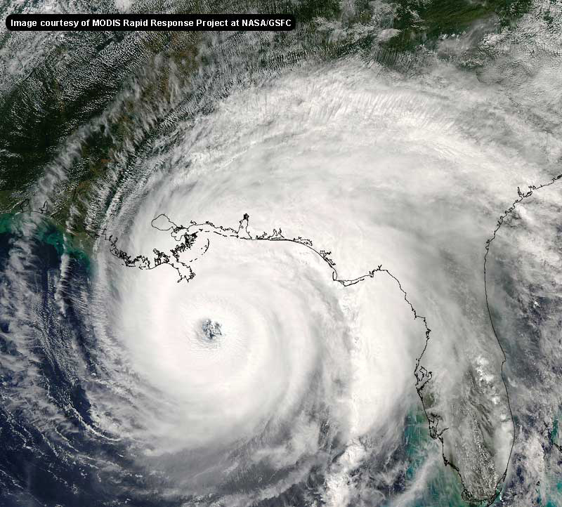
I suspect, judging from satellite imagery, that Bonnie's enhancement this morning is partially due to interactions with the frontal/midlatitude environment to it's north. The center is on the NW side of the mass of convection, a rather typical tropical/hybrid structure. If I recall correctly, we saw this with Danny a few years back, maybe even Earl not too far back. She's undergoing strengthening right now it seems, but I wouldn't say explosively. Near-hurricane strength is still a good bet.
You may be wondering how a tropical system can develop within a midlatitude environment, and I'll try to explain it a little. I'm not saying it's the predominant force behind Bonnie's growth, but it's probably playing some role.
Essentially, on a very basic level, there are two types of instabilities - barotropic and baroclinic. Baroclinic is what we actually see in the atmosphere, whereas barotropic is more idealized. However, tropical systems are nearly barotropic, while midlatitude systems are baroclinic in nature. That's the distinction I'd like to make here; the rest is just gory details. In any case, these instabilities drive the formation and growth of these systems.
The tropical case is more simplistic than the midlatitude case under this scenario (though many other factors I won't go into influence only tropical development); in this framework, the midlatitude case can be simplified to the tropical case by making a couple of assumptions. The energies behind the two instabilities are different, however.
Essentially, with interactions with the midlatitude environment, you get an additional set of energy - not an additive thing, just a slight bit more energy available for instability - for the tropical cyclone. The processes are still approximately tropical in nature - and the system is still tropical, particularly considering the warm waters of the Gulf and the core of the system - but I'd be willing to bet a high-resolution (cyclone phase) analysis of the core of Bonnie would suggest that the storm does not a very deep warm-core (tropical) structure.
I'd like to reiterate that this is a very simplified view of things, but may provide a little insight into the current enhancement and appearence of the system.
11am advisory & discussion are out - not much new, though they note the possibility of Bonnie reaching hurricane status in the 12-18hr period before weakening near landfall. Don't see any reason to disagree with that or the track. 11am info still to come.
--------------------
Current Tropical Model Output Plots
(or view them on the main page for any active Atlantic storms!)
|
LI Phil
User

Reged: Fri
Posts: 2637
Loc: Long Island (40.7N 73.6W)
|
|
reconnaissance and satellite data...and reports from NOAA buoy 42001
...Indicate Tropical Storm Bonnie has become much better organized
and has strengthened. Buoy 42001 located about 45 nmi northeast of
the center reported a 10-minute average wind of 41 kt with a gust
to 52 kt. Gradient wind computations using a 10 mb pressure
difference between Bonnie and buoy 42001 indicate near 50-kt winds
are possible. Therefore...the intensity has been conservatively
increased to 45 kt.
The initial motion estimate is 025/05. It appears that Bonnie has
passed north of the mid-level ridge axis that extends westward from
South Florida and is coming under the influence of an approaching
shortwave trough located over the Southern Plains. Bonnie is
expected to gradually accelerate over the next 24 hours and turn
more northeastward later today...if it hasn't done so already. The
global and regional models remain in good agreement on landfall
occurring Thursday morning in the Florida Panhandle. The main
concern is that with the mid-level winds forecast to become
southwest or west-southwesterly by 24 hours...Bonnie could make a
sharp turn more toward the east-northeast or east just before
landfall occurs. This would be to the right of the current forecast
track and this scenario will be closely evaluated for the next
advisory. Due to the uncertainty in the exact location and
intensity at landfall...a Tropical Storm Warning and a Hurricane
Watch have been issued for the previous tropical Strom watch area.
The intensity forecast remains problematic with the burst of deep
convection...tops as cold as -83c...that has developed over the
center this morning. If recon finds an eye or eyewall forming later
this afternoon...then it is possible that Bonnie could become a
hurricane between the 12 and 24 hour time periods...before
weakening occurs due to increasing wind shear just before landfall.
Factors supporting possible strengthening to hurricane intensity
are -- better inner-core wind field organization currently
ongoing...deep convection currently over the center...low shear
expected for the next 12 hours or so...and Bonnie passing over a
warmer Gulf Eddy in 12-18 hours during the nocturnal convective
maximum period tonight and tomorrow morning.
--------------------------------------------------------------------------
The good news is that Bonnie is not forecasted to make hurricane strength.
--------------------
2005 Forecast: 14/7/4
BUCKLE UP!
"If your topic ain't tropic, your post will be toast"
|
James88
Weather Master

Reged: Tue
Posts: 576
Loc: Gloucestershire, England, UK
|
|
Charley is now forecasted to become a hurricane later today. Maybe the interaction with Jamaica will prevent any significant intensification. Hopefully he won't do much damage there.
Edited by James88 (Wed Aug 11 2004 10:56 AM)
|
SirCane
Storm Tracker

Reged: Tue
Posts: 249
Loc: Pensacola, FL
|
|
Bonnie is looking in good shape. I think that it's a strong possibility that she'll become a Hurricane before landfall. 
hardcoreweather.com
--------------------
Direct Hits:
Hurricane Erin (1995) 100 mph
Hurricane Opal (1995) 115 mph
Hurricane Ivan (2004) 130 mph
Hurricane Dennis (2005) 120 mph
http://www.hardcoreweather.com
|
bobbi
Unregistered
|
|
go figure... would have said last night north of jamaica
this morning would have said.. south of jamaica
at 11am.. this loop... right on jamaica probably
|
joepub1
Storm Tracker
Reged: Wed
Posts: 240
Loc: Jacksonville,Fla
|
|
Other than a possible fix to how Bonnie gets over to the east coast, the is sticking to their guns. They seem to have a desent grip on the next 48 hrs. seems to be in much better shape then they thought; we could possibly see an eye somewhere between Jamaica and Cuba. Jamaica is more of a "hilly" island, went there in 1980. It might scratch a little bit, but not much. Western Cuba is Florida like in many ways, plus narrow to boot. Not much stopping him now from being whatever he's meant to be when he hits the gulf.
|
bobbi
Unregistered
|
|
When is that next system up around Wisconsin supposed to make it down this way?
http://orca.rsmas.miami.edu/wximages/jet/1_05/anis.html
watching unfolding developments of the interplay between elements in the atmosphere.. the NEXT big trof??
like some feedback, please
thanks
|
bobbi
Unregistered
|
|
is the ULL to 's west strengthening or not? has pulled it wnw for some time.. how will that play out today and tomorrow
|
rmbjoe1954
Weather Master

Reged: Tue
Posts: 427
Loc: Port Saint Lucie, Florida, USA
|
|
I'm reminded of Hurricane Floyd when he was supposed to come up right through the middle of the penninsula. He then veered to the right and gave all of us a sigh of releif!!
Yet, I don't see this happening with .
--------------------
________2024 Forecast: 28/14/8________
There is little chance that meteorologists can solve the mysteries of weather until they gain an understanding of the mutual attraction of rain and weekends. ~Arnot Sheppard
|
Anonymous
Unregistered
|
|
URNT11 KNHC 111443
97779 14434 40177 75200 15400 12045 16168 /2521 41035
RMK AF968 0203A OB 13
|
Frank P
Veteran Storm Chaser
Reged: Mon
Posts: 1299
|
|
If it maintains its current heading, it appears to me that the center of will pass just to the south of Jamaica. Regardless, they will be getting some of the worst of the weather but I don't think its impact with the island is going to weaken the system much, nor slow it down.... we'll find out soon
|


 Threaded

 [Re:
[Re: 


 Florida is really in for quite a ride with these two storms!


