Keith234
Storm Chaser

Reged: Thu
Posts: 921
Loc: 40.7N/73.3W Long Island
|
|
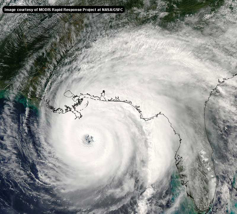
What's the satilite's cutoff for coloring all that air in brown, in terms of humidity? But that loop is a really good picture of how good it's outflow is, very wispy clouds mark the areas of good outflow. Actcually, I orbserved that outflow when I was following supertyphoon chaba. It's the combo of some shear and excellent outflow that produces very strong tropical cyclones.
--------------------
"I became insane with horrible periods of sanity"
Edgar Allan Poe
|
Keith234
Storm Chaser

Reged: Thu
Posts: 921
Loc: 40.7N/73.3W Long Island
|
|
Something could form but it is right now unlikely. Surface pressure is high, and the frontal boundary is starting to weaken, but then again you have more cold fronts on the way for some additional lifting, so we'll see then. But for right now looks the rain will continue to push on-shore and end during the night and then start back up again. I would be more concerned with .
--------------------
"I became insane with horrible periods of sanity"
Edgar Allan Poe
|
LI Phil
User

Reged: Fri
Posts: 2637
Loc: Long Island (40.7N 73.6W)
|
|
I wouldn't be so quick to write this one off. JB just did a midday missive on this system...to paraphrase...
---------------------
Current upward pulse of convection may be for real, and that is what is necessary to begin development. Some evidence a center may start to organize 50 miles east of Charleston. We won't know until tonight, because the convection must get going and stay organized. IF it does so, the outflow forecast is excellent, and it should stay over the warm water and continue to strengthen...At the very least, the potential for torrential rains exists for NC and the rest of the East Coast, with the additional potential for a strike from the following weekend.
---------------------------
JB's been wrong more than he's been right this year, but when he's been right, he's been dead on. I think anyone with interests in the Carolinas, especially the OB, had better keep an eye on this one. First Alex, then , possibly another tropical (subtropical) storm, then possibly ...I was actually planning an Outer Banks vacation in September...I hope it's still there. 
--------------------
2005 Forecast: 14/7/4
BUCKLE UP!
"If your topic ain't tropic, your post will be toast"
|
Todd
Weather Watcher
Reged: Fri
Posts: 30
Loc: Havelock, NC(34.89n76.92w)
|
|
LT Phil..... You forgot BONNIE this year also ... killed three in tornado near Wilmington from the remants as it passed over
Edited by Todd (Thu Aug 26 2004 01:49 PM)
|
LI Phil
User

Reged: Fri
Posts: 2637
Loc: Long Island (40.7N 73.6W)
|
|
Todd,
Sorry...it wasn't intentional. BTW, it's "LI" (as in Long Island) Phil, not Lieutenant. Don't feel bad, though, I've also been called Lil Phil too. 
BTW, 's up to 4.0/4.0, so we now have a hurricane on our hands. 
--------------------
2005 Forecast: 14/7/4
BUCKLE UP!
"If your topic ain't tropic, your post will be toast"
|
bobbi
Unregistered
|
|
http://hadar.cira.colostate.edu/ramsdis/online/Lasttrpg8wvL.html
shows your dry air pocket well.. shes doing pretty good in there
like a quaterback in the pocket
|
Keith234
Storm Chaser

Reged: Thu
Posts: 921
Loc: 40.7N/73.3W Long Island
|
|
This system off of the carolinas is right now ill-defined but in the loops it almost looks like it's almost converging at lower levels. If this system gets going it could become quite strong, JB might be right on this one.
--------------------
"I became insane with horrible periods of sanity"
Edgar Allan Poe
|
Ed in Va
Weather Master
Reged: Fri
Posts: 489
Loc:
|
|
Here's the discussion about the SC disturbance from the Wilmington NWS. Models all over the place, but no real mention of tropical features:
MODELS ARE STILL IN DISAGREEMENT WITH WHAT TO DO WITH THE SYSTEM
OVER THE NEXT COUPLE OF DAYS. THE ETA FINALLY RECOGNIZES THERE IS
INDEED SOMETHING OUT THERE PAST 12 HOURS INTO THE FORECAST. IT TAKES
THE LOW SW INTO N FL. THE TAKES THE SYSTEM WNW UP THE SAVANNAH
RIVER THROUGH SATURDAY. AN ETA SOLUTION WOULD ALLOW MUCH DRIER AIR
TO SLIDE SOUTH AND DRY OUT THE NORTHERN HALF OF THE CWA BEGINNING
FRIDAY. THE SOLUTION WOULD KEEP MUCH MORE OF THE AREA UNDER THE
GUN FOR SHOWERS. WILL SPLIT THE DIFFERENCE FOR NOW SINCE THE ETA WAS
SO UNRELIABLE YESTERDAY AND GO WITH 20-40 POPS MOST AREAS IN THE
SHORT TERM.
--------------------
Survived Carol and Edna '54 in Maine. Guess this kind of dates me!
|
tornado00
Weather Hobbyist
Reged: Sat
Posts: 85
Loc: Maitland, Florida, USA
|
|
Just a thought, is it totally out of the question that Florida, ironically, could get a hit again? I think that would be one for the history books! :?:
--------------------
Derek Sutherland
|
James88
Weather Master

Reged: Tue
Posts: 576
Loc: Gloucestershire, England, UK
|
|
Looks like is now a hurricane:-
http://www.srh.noaa.gov/data/WBC/CHGHUR.0408261846
|
Keith234
Storm Chaser

Reged: Thu
Posts: 921
Loc: 40.7N/73.3W Long Island
|
|
It's really never out of the question that Florida could get hit from the low off the southeastern coast but thats like saying what are the odds of getting struck by lighting twice in the same month. 
--------------------
"I became insane with horrible periods of sanity"
Edgar Allan Poe
|
Storm Cooper
User
Reged: Sat
Posts: 1290
Loc: Panama City , FL
|
|
Yes, very close....from the TWD...
TROPICAL STORM CENTER NEAR 13.1N 45.0W...OR ABOUT 1105
MILES...1775 KM...EAST OF THE LESSER ANTILLES AT 26/1500 UTC.
FRANCES CONTINUES TO MOVE WEST-NORTHWEST AT 15 KT. MAXIMUM
SUSTAINED WIND SPEED HAS INCREASED TO 60 KT WITH TO GUSTS 75 KT
AND THE ESTIMATED MINIMUM CENTRAL PRESSURE IS 990 MB.
--------------------
Hurricane Season 2017 13/7/1
|
tornado00
Weather Hobbyist
Reged: Sat
Posts: 85
Loc: Maitland, Florida, USA
|
|
Lord hopes that doesn't happen! Well we don't have anymore trees to lose so I guess thats the good thing about it. 
--------------------
Derek Sutherland
|
bobbi
Unregistered
|
|
http://www.ssd.noaa.gov/PS/TROP/DATA/RT/float-ir4-loop.html
|
Keith234
Storm Chaser

Reged: Thu
Posts: 921
Loc: 40.7N/73.3W Long Island
|
|
The northewesterly track has begain, it now seems more likely that it will impact the US. I wonder what will happen if comes in contact will the low off of the southeastern coast, very interesting.
--------------------
"I became insane with horrible periods of sanity"
Edgar Allan Poe
|
SirCane
Storm Tracker

Reged: Tue
Posts: 249
Loc: Pensacola, FL
|
|
The way the forecast track bends to the West reminds me of Andrew's track.
|
WeatherNLU
Meteorologist

Reged: Sat
Posts: 212
Loc: New Orleans, LA
|
|
Quote:
The northewesterly track has begain, it now seems more likely that it will impact the US.
Huh? What northwesterly track?
--------------------
I survived Hurricane Katrina, but nothing I owned did!
|
WeatherNLU
Meteorologist

Reged: Sat
Posts: 212
Loc: New Orleans, LA
|
|
More importantly, every model now takes south of 20/60 and most have well west of 60 before 20N.
--------------------
I survived Hurricane Katrina, but nothing I owned did!
|
rmbjoe1954
Weather Master

Reged: Tue
Posts: 427
Loc: Port Saint Lucie, Florida, USA
|
|
Still, the effects of the ridge will have much to do with the whereabouts of Francis by the time it gets near to PR or Hispaniola- if and only if it gets that far south and west.
--------------------
________2024 Forecast: 28/14/8________
There is little chance that meteorologists can solve the mysteries of weather until they gain an understanding of the mutual attraction of rain and weekends. ~Arnot Sheppard
|
bobbi
Unregistered
|
|
so far today it traveled wnw...then a drop more westerly.. than again wnw
you have to look at the movement over time..
that is how does track so..they will stay with wnw
but... as a storm builds its path is not always fluid and hard to see where the shape of the eye turning distorts what looks like movement
looks like a real stair stepper to me
which makes it harder to figure out
anyone see it slowing down?
Heard this morning that it would begin to be affected by different steering currents and begin to slow down forward progress.. dont see it yet.
|


 Threaded


 [Re:
[Re: 


