CFHC

Reged: Sun
Posts: 148
Loc: East Central Florida
|
|
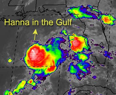
Expected to be no more than a Tropical Storm, Hanna forms from Tropical Depression Nine in the Gulf.
Approximately 250 south of Pensacola, it's moving erratically, generally expected to turn to the north. A good rain event for the Pensacola in the panhandle and possible Alabama as well. The exact strength or landfall track is up for grabs.
A system east of the Caribbean in the Atlantic is another potential for the next depression. We're watching that also.
Apologies for lack of updates this week. It's been unavoidable.
NRL Monterey Marine Meteorology Division Forecast Track of Active Systems (Good Forecast Track Graphic and Satellite Photos)
NASA GHCC Interactive Satellite images at:
North Atlantic Visible (Daytime Only), Infrared, Water Vapor
Some forecast models:
NGM, AVN, MRF, ETA ECMWF
DoD Weather Models (NOGAPS, AVN, MRF)
AVN, , , , , UKMET
Other commentary at Mike Anderson's East Coast Tropical Weather Center, Accuweather's Joe Bastardi, Hurricane City, Gary Gray's Millennium Weather, Barometer Bob's Hurricane Hollow, Snonut, Ed Dunham and Jason M in our Storm Forum Even more on the links page.
- [mac]
|
Frank P
Veteran Storm Chaser
Reged: Mon
Posts: 1299
|
|
Morning all.... Northern gulf coasters have something to watch for sure today....
Hanna is maintaining its deep convection to the south of the LLC this morning based on latest IR... started developing this convection last night around 10:00 pm... thus the upgrade to TS. This is our second TS warning for the MS coast this year, and if old Edouard would not have fizzled out, we could have experienced three TS warnings ... whether or not Hanna impact the MS area that much remains to be seen as I would expect the center to pass to the east of us, along with all the associated severe type weather. .. but the more this thing drifted west, as it has done the past 24 hours, the more likely the had to extend the warning areas to the west..
From what I monitored last night and this morning, the system did not make any discernable loop per se, nor did the LLC wash out and relocate to the SE.... what it does next remains to be seen...
|
Cycloneye
Storm Tracker
Reged: Thu
Posts: 373
Loc: Puerto Rico
|
|
http://www.srh.noaa.gov/data/sju/AFD/SJUAFDSJU.1.txt
Here is the discussion from the NWS in San Juan that says all of what this potential wave soon to be TD#10 will do in the caribbean this weekend.I will keep in touch with all the info that will come regarding this system that by the time it nears PR it may be TS Isidore.
--------------------
My 2004 hurricane season forecast=13/8/3
|
Frank P
Veteran Storm Chaser
Reged: Mon
Posts: 1299
|
|
Several models take the system just east off the mouth of the MS River and then turn Hanna back to the NNE� has it going through Ocean Spring/Pascagoula Ms area, but predicted intensity is off because the storm is already stronger right now than the model indicates it will be at land fall�
Hey Cycloneye, you keep us informed on what's going on down there... right now people along the gulf coast are focusing a little closer to home... but anything in the Caribbean down the road is always an interest to us...
|
Frank P
Veteran Storm Chaser
Reged: Mon
Posts: 1299
|
|
223
URNT12 KNHC 131134
VORTEX DATA MESSAGE
A. 13/1134Z
B. 27 DEG 20 MIN N
89 DEG 15 MIN W
C. NA
D. 20 KT
E. 300 DEG 020 NM
F. 012 DEG 28 KT
G. 303 DEG 019 NM
H. EXTRAP 1002 MB
I. 24 C/ 380 M
J. 25 C/ 384 M
K. 24 C/ NA
L. NA
M. NA
N. 1345/1
O. 0.1/3.0 NM
P. AF968 0609A HANNA OB 03
MAX FL WIND 28 KT W QUAD 1127Z. SLP EXTRAP FROM 1500FT.
|
Anonymous
Unregistered
|
|
>>AT 7 AM CDT...1200Z...THE CENTER OF TROPICAL STORM HANNA WAS LOCATED
NEAR LATITUDE 27.3 NORTH...LONGITUDE 89.2 WEST OR ABOUT 250 MILES
SOUTH-SOUTHWEST OF PENSACOLA FLORIDA.
This storm has already moved beyond 89 west. NO advisory or discussion by the TPC or really anyone here but Frank P had the storm crossing 89. The storm is moving NW at 7. While I expect a turn to the N and then NE like almost all North Gulf storms do, I'm sticking with my landfall between Biloxi and Daupin Island. New Orleans just got our first little band (?) of rain moving through. It was pretty strong and lasted for about 4 minutes. Not much wind, just a downpour. I haven't even made it over to the NWS to see where it came from, but I'm assuming it developed S and moved across.
As noted by several people yesterday, the MLC was NOT going to take over this storm. In any event, heavy rains should affect MS, AL and FL and POSSIBLY (but less likely) extreme SE LA tonight and tomorrow. I'm betting Hanna reaches at least 60 knots by landfall and should make for an interesting weekend for everyone east of me and west of St. George.
Goes to show that none of us - including the experts in Miami, State College and Washington DC really ever knows what's going to happen with a tropical storm. There's a lesson in this storm - as in most - that it's all guesswork.
Steve
|
Anonymous
Unregistered
|
|
http://www.srh.noaa.gov/radar/loop/DS.p38cr/si.klix.shtml
Came up from the south. It's the most-outer band. So hey, I guess I can't complain about this season - nothing overly exciting in N.O., but rain from at least 3 different systems has fallen on my house this year. That hasn't happened since 1985.
Steve
|
Frank P
Veteran Storm Chaser
Reged: Mon
Posts: 1299
|
|
Ms Hanna doesn't look at that impressive to me right now... looking at the latest IR loop it certainly gives the impression she continues to have stacking problems, in that the MLC might still be off to the east somewhat... still has plenty of time to reach strong TS status though... regardless, should be quite a rainmaker for somebody, and hopefully in the areas of AL/GA that really need it...
Looking forward to the first visibles...
|
Anonymous
Unregistered
|
|
Guess we better keep an eye out. That blob is getting bigger. BarryB
|
Anonymous
Unregistered
|
|
http://www.ssd.noaa.gov/PS/TROP/DATA/RT/float-ir2-loop.html
Latest IR shows almost a WNW movement of Hanna. Give cudos to the and Canadian models which appear to have the best handle on the system though may be biased westward. Should Hanna continue to move NW until at least the 1PM CDT advisories come out, it's a mouth of the Missississipi storm. Let me say that I have not even once speculated this far of a western component if it holds up. I will be surprised.
Steve
|
Anonymous
Unregistered
|
|
Looking at the Shortwave IR, the LLC seems to be due south of the mouth of the Mississippi moving generally off to the west. One thing is for sure, she is still poorly organized.
I don't know what to think, I guess we will just have to watch and see what happens. 
Houstontracker
|
Frank P
Veteran Storm Chaser
Reged: Mon
Posts: 1299
|
|
with these tropical systems because I stay surprised... they sure can make me look silly at times with my analysis that's usually already off by the time I post it... Hanna is going to have to make a big right hand turn soon... or throw out all the models and start over... still looks to be a marginal TS at best right now, and that's being generous by the ... buoy data basically supports a TD only...
fun huh...
|
Anonymous
Unregistered
|
|
Yea for sure. Looks like the last couple of frames on the loop are coming up blank now, must be some sort of problem.
Looks to me like Hanna might be a Louisiana landfall now, really gonna have to make a big turn to miss. Still, most of the weather should be well east of the center unless she can get it together soon.
Something still might be brewing in the BOC along the Mexican coast. I would just as soon see Hanna get out of the way and see if we can get a true tropical system going down there.
Houstontracker
|
wxman007
Meteorologist
Reged: Sat
Posts: 617
Loc: Tuscaloosa, AL
|
|
I sure didn't think we'd see this much west component last night....kudos to you Frank!
2 vis's in so far...too early to tell much about motion, but the structure is basically unchanged...be interesting to see if she can convect in the next few hrs...
--------------------
Jason Kelley
|
HanKFranK
User

Reged: Mon
Posts: 1841
Loc: Graniteville, SC
|
|
think maybe its back online, but goes 8 was out for a while this morning, giving garbage images. not too hard to discern that the west/weak option is the viable one with hanna. instead of turning NE into a more favorable environment the storm decided to suck up more subsidence back west.. so what we have is the new version of the same old thing: for the life of this system it has insisted on shooting itself in the foot. funny that 2nd guess at pascagoula, which was based solely on the first leg of that little westward semicircle jog hanna took yesterday morning.. may actually end up working.
so, deep convection removed, center in the subsidence, weaker west option with hanna. basically another bertha for all of you on the central gulf coast.
99L... its moving fast. for all the better organization seen with it, it still has this basic problem: forward speed. hadnt really considered this until i thought about every other fast moving weak system near the caribbean.. they all tend to remain poorly organized until they slow down. maybe it has slowed just a tad since yesterday.. but not going to develop very fast unless it does some more.
up the road, probably will have developed into something.. a struggling system moving westward across the caribbean might in the long run be worse for us. a quick developer would want to take the first trough elevator out into fish spinner country it could find. something over in the western carib this time of year though.. heh.
west gulf: bastardi still eyeballing it so maybe that nagging suspicion is true. can see some disorganized convection down there right now, nothing too ominous looking.. but after hanna gets out of the way NE this area could try to spawn something.
other items: TD7 remnants are now a pulse ahead of the big longwave off the east coast.. good riddance.
system near 25/55 right under the upper trough, not appearing very well organized, but still plenty of convection to go. the whole upper pattern here is transitioning, so hard to say exactly what happens with wave energy injected underneath. all in all not as organized as yesterday.
another fairly large wave came off africa the other day with no fanfare. no signature outside the though.. but the enhanced convection down there is fairly prodigious. sideways chance, but something to monitor down the road (globals are noticing it even if theres not much on satelite).
a'ite, bout time for the next advisory..
HF 1440z13september
|
Frank P
Veteran Storm Chaser
Reged: Mon
Posts: 1299
|
|
thanks... gotta give Steve a pat on the back to as he was the only one on the board that predicted a landfall west of Al. Yesterday he said between Biloxi and Dauphin Is... so cudos to my Nawlins neighbor too..
one thing bothers me about this setup...
wouldn't you expect that the longer Hanna stay out, not really moving that fast towards the north, the greater the turn off to the NE will be... for MS to really have any impact, I would think that Hanna needs to hurry up and go more north... the longer its stays out, the greater the impact would be to the east of MS ... still making it a weather event for Al and Fl coasts...
Radar shows the first feeder bands approaching the MS coast this morning...
Center appears to be located at 27.6 and 89.4 based on latest vis pix...
|
Tony
Unregistered
|
|
I-75 Terrorist Investigation
I know it is off topic, and we are watching Hanna, but for anyone near I-75 (Alligator Alley) in Florida, it is closed for approx 20-25 miles due to investigation of *possible* terrorist plan to attack Miami. Live coverge on CNN,MSNBC, and Fox News. Just an FYI.
|
Frank P
Veteran Storm Chaser
Reged: Mon
Posts: 1299
|
|
gotta give HF his credit as well because he predicted the pascagoula Ms area as well yesterday when we first started getting the wobble westward... be interesting to see where it eventually goes.... I'm still not counting out Pensacola as the target area...
|
doug
Weather Analyst
Reged: Mon
Posts: 1006
Loc: parrish,fl
|
|
Question: this thing is like the other recent stroms...exposed LLC...all the convection being dropped or slughed off to the south and east...so what happens to all that energy that is being left behind as it moves inland tonight? is that going to fuel development in the bay of Campeche?
--------------------
doug
|
Anonymous
Unregistered
|
|
they are teens making small explozies for they're stupid gang wars with a gang in Miami.
|


 Threaded


