CFHC

Reged: Sun
Posts: 148
Loc: East Central Florida
|
|
Update 11am EDT, 17 Sept 2002:
Tropical Depression # 10 is back! Advisories have restarted as of 11am EDT.
---
Original Post:
Tropical Depression 10 was downgraded to an open wave by the National Hurricane Center, and it is causing a lot of controversy. A recon aircraft was sent out today but could not find the LLCC (lower level circulation center). So this system officially still remains an open tropical wave. Although looking at visual satellite photos of the system it appears to have some sort of circulation, in any case this system is in a very favorable area for intensification and storm development and must be monitored. So we will be keeping a close eye on this one.
In the comments section (Forums) everyone is doing a great job in tracking this storm. Thank you and keep up the good work.
Caribbean Hurricane Page - includes reports from individuals scattered across the Caribbean islands
NRL Monterey Marine Meteorology Division Forecast Track of Active Systems (Good Forecast Track Graphic and Satellite Photos)
NASA GHCC Interactive Satellite images at:
North Atlantic Visible (Daytime Only), Infrared, Water Vapor
Some forecast models:
NGM, AVN, MRF, ETA ECMWF
DoD Weather Models (NOGAPS, AVN, MRF)
AVN, , , , , UKMET
Other commentary at Mike Anderson's East Coast Tropical Weather Center, Accuweather's Joe Bastardi, Hurricane City, Gary Gray's Millennium Weather, Barometer Bob's Hurricane Hollow, Snonut, Ed Dunham and Jason M in our Storm Forum Even more on the links page.
- [john@flhurricane.com]
|
Robert
Weather Analyst

Reged: Sat
Posts: 364
Loc: Southeast, FL
|
|
I was thinking the orginal forcast called for this to be here on tues/wendsday then thur/frin ow fri/sat.I was wondering what evryone's thought on it just going through the bahamas seeing the dead line keeps getting pushed back, That trough wont wait forever. Im not saying i think this will happen just thought id throw that possibilty out there?
|
scottsvb
Weather Master
Reged: Mon
Posts: 1184
Loc: fl
|
|
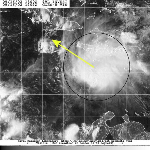
Current conditions show SW sheer inhibiting any rapid intensification of the carribean system. No LLC found by recon means no watches for Jamaica but will be informed on TS winds that will affect the island late tonight thru Thurs. Currently there is a weak LLC near 15.8N and 75.8W moving just north of west at 280' at 18 mph. Due to the moderate sheer, rapid speed, and weak low pressure in the system it can not intensify quickly. Alot of heavy showers are off to the east and northeast of the center. This will continue to spread over the Haiti area and Jamaica tonight.
For Track and intensity I will say there is a weak LLC and it will begin to slow just a bit and move to the NW later tonight into Tues. The system should be namedlater when the NEXT recon goes in or when ship and buoy reports come out of the system with any kind of W wind. Tuesday the sheer will dominish some but will still be there. I dont expect alot of strengthning to a hurricane until later Weds or that night if at all. First we want to close this thing. Track will take this SW of Jamaica by later tuesday and very near the Grand Cayman island early weds. With a upper anticyclone to the NE of the system and lowering heights in the central g-o-m a more turn to the NNW will take shape later Weds night with land fall near 81W early on Thurs and as a posible hurricane then. After about 6-8 hours of crossing the small area of Cuba it should re enter the Fla straits late Thurs or night. The forcast then is for more strengthning and a N motion Thurs night and a slow NNE or NE turn to take shape. Friday - Friday night should be a landfall. The areas of concern are wide spread this far out. Areas from N of Tampa all the way around the state to Miami's SE area could be in direct line. The turn to the NNE or NE is what it all comes down to. Cant make the exact point yet. As for intensity, right now going just under the with a Cat 2-3. Some sheer might again be felt of the system on Friday ahead of the strong trough and cold front to its NW. So expect LLC to form overnight, TS on Tuesday to move close to G Cayman later on weds to cross w central Cuba very late Weds night or most likely Thurs as strong TS or weak hurricane, move N and threaten Key west early Friday and the SW florida area but very wide area indeed later that day. Tampa-Miami. is best model for this and . Avn is next. Ill post more later in detail on Tues if and when this devolps. scottsvb
|
StormHound
Weather Guru
Reged: Sun
Posts: 187
Loc: Orlando, FL
|
|
Based on the latest satellite photos, there is little doubt in my mind that TS Isidore has been born, or soon will be. He is wrapping up tightly. Bastardi mentioned that there would be storms in the outflow during birth, but these would give way to high cirrus clouds as she closes off. That is what I'm seeing over the last couple of hours.
He seems to have slowed down now, but Cuba and Florida certainly are under the gun. Because of the angle of attack, guessing anywhere other than the Keys is going to be very difficult. A little wobble could mean the difference between West or East coast of FL. If I have to make a call now, I'd say Isidore gets far enough W to come up the W side, say between Sarasota and Tampa. I'm thinking strong Cat 2, but we should be watching this one very closely.
--------------------
Storm Hound
Computer Geek
|
Kevin
Weather Master

Reged: Fri
Posts: 524
Loc: EC Florida
|
|
My thinking is that the Bahamas may feel very little effect from this system. I'm still thinking it should keep moving towards the wnw at 10-15 mph for at least the next 36h.
Analog storms: I've picked out some storms that seem to be at least somewhat similar to this one. Although some formed in different places, I believe with one of the storms the outcome may be the same as with this one.
http://weather.unisys.com/hurricaen/atlantic/1944/11/track.gif
This track looks like the most similar to this storm at this time. This storm was never a quick mover and effected western Cuba as a hurricane but then weakened as it went over. When it emerged over water, it was moving slowly but it re-intensified into a category 3 hurricane. Looks quite similar to this one.
http://weather.unisys.com/hurricane/atlantic/1953/FLORENCE/track.gif
This one formed in a similar place to the 1944 storm but tracked further west. This has a much lower chance of being similar to our current storm than the 1944 one does. The trough that should effect this system looks to be very sharp. Shouldn't allow this one to get up to the Florida Panhandle.
Of course, there could be some variations in intensity. Another thing I wanted to point out: It seems whenever we have a tropical wave producing tropical storm forced winds but with no closed circulation we eventually see development. It also seems that these storms don't tend to stop developing when they hit land. With Erin in 1995, it was a rainmaker for the Florida Peninsula but when it hit the Florida Panhandle wind damage was far greater than with Erin's first hit. Wil this storm be the same way? Rainfall a main threat in Cuba with wind being the main threat in Florida. Time will tell.
Also, in years similar to this one where activity is pushed closer to the US and more numerous in the GOMEX it seems Florida always get a cat.2 or cat.3 from the south. Just a trend I noticed from some years.
Kevin 
|
ShawnS
Storm Tracker
Reged: Fri
Posts: 226
Loc: Pearland,Tx
|
|
Get out of town, we are talking western gulf with this one, if anything at all!
|
troy2
Storm Tracker
Reged: Sat
Posts: 227
Loc: cocoa beach
|
|
Nice thorough and detailed forecast Scott!
BTW what is the link to your website?
|
Cycloneye
Storm Tracker
Reged: Thu
Posts: 373
Loc: Puerto Rico
|
|
Wow Scott that was a very complete anaylisis of all the possibilities with this system that looks like it has the look of a major cane but of course to early to say that with authoritie but this system covers a big area and systems like that big are the most ones to be formidble canes.
--------------------
My 2004 hurricane season forecast=13/8/3
Edited by Cycloneye (Mon Sep 16 2002 07:54 PM)
|
Anonymous
Unregistered
|
|
saw lyons on band coming around center is pushing keeping away shear. could be close to path of donna 1960. also is very close to where gilbert was when it exploded. will be cat.3 in a few days.
|
Robert
Weather Analyst
Reged: Sat
Posts: 364
Loc: Southeast, FL
|
|
well the shadow of darkness is prevailing and i am going to what i should have done last and turn off the comp early. I dont excpect a whole lot tonight maby more organization nothing that wont be there tommorow morning when vis comes back. Well nice tracking with you this afternoon and good night
|
Kevin
Weather Master
Reged: Fri
Posts: 524
Loc: EC Florida
|
|
Good night Robert, had a great time tracking this stuff with you today. Indeed, a lot of fun. Now onto the storm structure at this point. All I can say is BANG! This afternoon the storm had an elongated look, but now it is a nice round ball. It is becoming "incubated", as Joe Bastardi says. A track to Donna in 1960 is also a possibilty. Didn't throw that in with the analogs due to the fact it was a Cape Verde storm. I also agree with a category three storm...this one seems destined for that as long as it can develop a closed LLC. I see that happening overnight. Tomorrow will be a big day for this system, no doubt in my mind.
Kevin
|
ShawnS
Storm Tracker
Reged: Fri
Posts: 226
Loc: Pearland,Tx
|
|
I think you all are making too much of it right now. It is not even classified yet. I remember going through this last year with these systems. There were at least a couple of them that we all thought would really pop and they never did for some reason or another. The same could happen here and that might be the reason the is holding off on any reclassification right now. The longer it goes without getting its act together, the greater the chances of it either totally falling apart or at least moving further west than anticipated. I'm not saying that it WON"T happen but I think I'll wait until we get an official notice from the that this thing is for real before I go any further. Who's to say that it won't make it to the western gulf,IF it does re-form. How many times has a high pressure not built in as deep as it was suppose to or moved a little east or west of where it should have? How many times has a trough not dug as far south as forecasted or not been able to "pick up" a system because the storm decided to slow down or even stall out. The point I'm trying to make is that it is anyone's guess on what may happen with this thing. It could go anywhere from just falling apart to being a major hurricane, and anything and everything in between. Saying that, we ALL need to just keep an eye open to the possibilities that exist..... ALL the possibilities.
|
Anonymous
Unregistered
|
|
this one was also a cape verde system. i think gilbert was 1988, is that right kevin. mark
|
Anonymous
Unregistered
|
|
that thing in the gulf had a name and this thing dont
|
Bruce
Weather Guru
Reged: Fri
Posts: 139
Loc: Palm Bay, Florida
|
|
I think it will be called "SOMETHING" By 11PM, 5AM Max. Talking like its a TS.
|
Joe
Storm Tracker
Reged: Mon
Posts: 216
Loc: St.Petersburg,FL
|
|
Cold tops still cold and holding its own. Should be intresting when Recon goes in tomorrow when they find possibly a strong TS. As far as future track it looks to be headed for FL, East/West coast? who knows. Its all going to be a timing thing with the trough movement and tropical disturbance or should I say Isidore.
|
troy2
Storm Tracker
Reged: Sat
Posts: 227
Loc: cocoa beach
|
|
Gilbert is a good example of how fast a storm can intensify.
went from 960mb to 888mb in just 24 hours. Granted it was already well on its way before that and already a strong Hurricane.
troy
|
Anonymous
Unregistered
|
|
people are just giving their ideas. conditions will favor strengthning, high 80 water temps, and as lyons said what little shear there is is moving west away. plus forward speed is slowing down alot. and water temps are very high also near fla. straits. ridge is expected to weaken some so going west is unlikely.
|
Kevin
Weather Master
Reged: Fri
Posts: 524
Loc: EC Florida
|
|
This system orgininated from an African that was very disorganized while going across the Atlantic. It was never classifed during that time, so it wasn't a Cape Verde system. Gilbert DID develop in the Atlantic, making it a Cape Verde system.
Shawn: It may not have an official entity tonight but I'm nearly 100% certain it will tomorrow. This system has major potental, starting tomorrow and especially after 36 hours. Given it regenerates it also has a good chance of effecting Florida late this week. Floridians (like myself) must keep an eye on this. Not even an issue for Texas unless something majorly unexpected occured.
Maybe one more post tonight, otherwise I'm done for today.
Kevin
|
Anonymous
Unregistered
|
|
it was a wave that came from africa and passed thru cape verdes.
|


 Threaded


