MikeC
Admin
Reged:
Posts: 4544
Loc: Orlando, FL
|
|
8:00PM
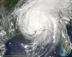
Cindy is approaching the Louisiana coastline as a strong tropical storm, with a pressure of 992 mb, it may be a rough night there in Louisiana-- if the weather warnings for the area does not tell that tale as is. The approach toward New Orleans that Cindy has may cause some surge as well. I hope this doesn't wind up catching some people in the area off guard.

has strengthened slightly over the day, and may be a hurricane in a day or two. A Hurricane Watch is now up for Jamaica because of this. And the Caymans will likely follow soon as well
A full new update will come around the time of the 's 11pm update.
2:15PM
See Clark's Blog Update Below this news article for more thoughts on Cindy and .
10:45AM
Tropical Depression #4 is now Tropical Storm . The earliest "D" named storm in recorded history for the Atlantic Basin. will likely to continue to strengthen. Tropical Storm Watches are up for Hati and the Dominican Republic.
Cindy is gaining a bit of strength as well and may well be a moderate to strong Tropical Storm upon landfall. Continue to watch this.
I know a lot are wondering aobut ' future track and we'll be updating comments on that as time goes along. Right now there is a lot of long range uncertainty. So it really is too early to say where in the US the storm will track, but Florida, and the Gulf States will need to watch this one closely. Anything now is speculation.
Jamaica and Cuba will be dealing with soon as well. There are no real reason I can see that would prevent from becoming a hurricane over the next day or two.
Got a question, have an observation you have seen?, interesting link, reply and let everyone know.
More to come later...
7AM
Tropical Storm Cindy has formed from Tropical Depression Three in the Gulf, Tropical storm Warnings have been issued for Louisiana, and eastward to Pascagoula, Mississippi. Including New Orleans.
The storm remains still somewhat disorganized, and upper level winds aren't all that favorible for it to get much stronger. However, it still has a shot maybe to become a moderate to strong Tropical Storm. Thankfully i don't think it can get beyond that.


TD#4 continues to look better organized this morning and will likely become Tropical Storm later today. The forecast there is for it to arrive in the eastern Gulf, after crossing Cuba. The margin of error will keep us floridians watching very closely over the next few days. Other areas along the Gulf should keep watch too, after dealing with Cindy.

Original Update
Fireworks on July 4th in the Tropics. Thankfully neither are really big boomers. But will need to be watched, especially TD#4.
Tropical Depression #3 remains disorganized, and has relocated the center to the North. The National Hurricane Center has placed Tropical Storm Watches up along the Coast of Louisiana, excepting New Orleans and points east. The system may become Cindy before it strikes land. It's still a difficult storm to find the exact center of, and it may reform itself again.

Tropical Depression #4 has formed in the Eastern Caribbean Sea, and the trends have it going through the larger islands in the Western Caribbean, and eventually making its way closer to Florida. This will require close watch over the next few days for us in Florida. As well as those in the Caribbean Including Hati, Cuba, and Jamaica. They will all want to watch the storm closely. Land interaction with the islands will determine the future impact on any US landfall. Florida and the Gulf coast must keep a watch on this one during the week. As the forecasted intensity puts it at Hurricane Strength.
Again, Tropical Depression #4 will be one to watch over the coming week (very likely to be ). For US Interests in Florda along the Southern, Western and Pandhandle coastline. Unfortunately.
Event Related Links
StormCarib hurricane reports from observers in the Islands
Caribbean Island Weather Reports
Cindy:
Animated Model Plot of Cindy
Model Plot Graphic from the South Florida Water Management District of Cindy
Color Satellite of Gulf of Mexico
Mobile Bay Long range Radar
Joseph Johnston's Mobile Bay Webcam
New Orleans Long range radar
Visible Satellite Loop of Cindy
Dennis
Animated Model Plot of
Model Plot Graphic from the South Florida Water Management District of
|
Colleen A.
Moderator

Reged:
Posts: 1432
Loc: Florida
|
|
I have to tell you: I don't know why they didn't include the greater N.O. area except for this: they're not all that sure that the track isn't going to pull a little more to the right in the next 36 hours. Who knows what it will do?
TD#4: Please don't let those models verify. I've had enough of this already. Just keep going west.............
--------------------
You know you're a hurricane freak when you wake up in the morning and hit "REFRESH" on CFHC instead of the Snooze Button.
|
MikeC
Admin
Reged:
Posts: 4544
Loc: Orlando, FL
|
|
test reply..
I don't want to downplay TD#3 too much. It is in the Gulf, after all. It will need to be watched too, especially with the center reforming.
TD#4 is going to be the lion's share of discussion this week, I have a feeling. if anyone notices anything interesting with either system, please put up a reply here.
|
Doombot!
Weather Guru

Reged:
Posts: 160
Loc: Lakeland, Fl.
|
|
... I have a bad feeling about this one.
edited to remove remarks~danielw
Edited by danielw (Tue Jul 05 2005 04:58 AM)
|
Wxwatcher2
Storm Tracker

Reged:
Posts: 337
Loc:
|
|
As spock would say......"intersting Captain"........and so it begins again.....
I'll be glued to this site all week long......we're already soaked to the gills in Central florida......
|
dem05
User
Reged:
Posts: 368
Loc: Port Charlotte, FL
|
|
Colleen,
N.O. probably wasn't included in the watch at this time because of #3's poor structure, and it is not a TS. N.O. is somewhat inland. If the system was to become a stronger one, and promised to track a bit further east, I am sure the would post a watch for them too.
Not to move on to the next. #4 has a lot more potential to be a formidable risk to people. Just remeber there is a forecast cone of error and that is what to watch.
On a final note, Tallahassee's Afternoon Discussion (LINK: http://www.srh.noaa.gov/fwd/productviewnation.php?pil=TAEAFDTAE&version=1 ) mentioned that the very busy 1995 hurricane seson (with and active early term) did not produce it's fourth system until July 30. It mentions concern that we a hyper ahead of schedule. Remember that season produced 19 systems, only surpassed by 1933 (with 21) and we are in a pattern more conducive for landfalls than 1995. Do not want to get the cart ahead of the horse from here, but it is something to think about.
P.S. Exact quaote in case link shifts with the issuance of a newer discussion:
.SYNOPSIS...BOY, IT'S TURNING OUT TO BE A BUSY EARLY SEASON IN THE
TROPICS. HERE IT IS ONLY INDEPENDENCE DAY, AND WE ARE LOOKING AT THE
THIRD TD OF THE SEASON ABOUT TO EMERGE INTO THE GULF OF MEXICO, AND
A VERY HEALTHY LOOKING TROPICAL WAVE MOVING THROUGH THE WINDWARD
ISLANDS. IT IS QUITE POSSIBLE THAT WE WILL BE DEALING WITH BOTH
CINDY AND THIS WEEK. EVEN IN THE VERY BUSY 1995 SEASON, IT
TOOK UNTIL JULY 30TH FOR THE D STORM TO FORM. SSMI DATA AND RECENT
VISIBLE PIX INDICATE THAT THE CENTER OF TD 3 MAY HAVE REFORMED JUST
OFF THE NRN YUCATAN COAST. REGIONAL RADARS SHOW CONVECTION HAS
DEVELOPED BENEATH A A VORT CENTER OVER ERN MS AND NWRN AL. A
CONVERGENT BAND WELL N OF TD 3 SPARKED SHOWERS OVER THE NE GULF AND
EARLY THIS MORNING. THIS AREA HAS WORKED STEADILY INLAND THROUGH THE
DAY, AIDED BY THE SEA BREEZE. ANOTHER AREA OF CONVECTION IS
APPROACHING OUR OFFSHORE COASTAL WATERS. THIS IS ASSOCIATED WITH A
VORT LOBE EXTENDING NWD FROM TD 3.
Edited by dem05 (Tue Jul 05 2005 05:07 AM)
|
Hurricane Fredrick 1979
Weather Guru

Reged:
Posts: 116
Loc: Mobile,Alabama
|
|
The Eastbank of N O is not under the watch. The westbank I beleive is. Jefferson Parrish which butts to Orleans Parrish is under it. If a Hurricane above a 3 was to hit they would blow the levee up and then the westbank would flood out. There goes my other house.
|
hurricane_run
Storm Tracker

Reged:
Posts: 366
Loc: USA
|
|
thankfully it is not that strong
|
HanKFranK
User

Reged:
Posts: 1841
Loc: Graniteville, SC
|
|
as for t.d. 3... it seems to be doing its best isidore impersonation. remember isidore was that strong hurricane that had the gulf coast all worried the last week of september 2002, but beached itself on the yucatan and never rebuilt it's core. honestly think it's been a t.s. most of the afternoon/evening... recon will drop by in the next few hrs and confirm or sink this assumption. because of the relocation the steering mechanisms would tend to take the center further east.. but in the weaker state it's in the system will not recurve as easily. while the path is open further east now (ms/al), the core has to get reorganized for that steering mechanism to kick in. i don't know anymore... the yucatan crossing really knocked my ideas with this one off balance.
t.d. 4 has been officially christened. the could have done it at five, but they played it down like they usually do. doggone thing looks like it's getting clear of the south american coast.. it'll spin up slowly for the first day or two.. but that intensity in the extended period is advertising is definitely conservative. it has a bunch of islands to negotiate, and exactly how it does that will control the intensity and path to a degree. the prog right now for track looks sound to me.
gonna be a long week coming up.
HF 0703z05july
|
hurricane_run
Storm Tracker

Reged:
Posts: 366
Loc: USA
|
|
The T# for TD#3 is 2.5 thats 40 mph. By 5 or 11am we will have TS Cindy
|
hurricane_run
Storm Tracker

Reged:
Posts: 366
Loc: USA
|
|
pressure in TD3/Cidy is down 3mb to 1006
|
danielw
Moderator

Reged:
Posts: 3525
Loc: Hattiesburg,MS (31.3N 89.3W)
|
|
TROPICAL STORM CINDY FORECAST/ADVISORY NUMBER 7
NWS TPC/NATIONAL HURRICANE CENTER MIAMI FL AL032005
0900Z TUE JUL 05 2005 (edited~danielw)
AT 4 AM CDT...0900 UTC...A TROPICAL STORM WARNING HAS BEEN ISSUED FOR THE NORTHERN GULF COAST FROM INTRACOASTAL CITY LOUISIANA TO PASCAGOULA MISSISSIPPI INCLUDING THE CITY OF NEW ORLEANS AND LAKE PONTCHARTRAIN...AND A TROPICAL STORM WATCH HAS BEEN ISSUED FROM EAST OF PASCAGOULA TO DESTIN FLORIDA. THE TROPICAL STORM WATCH WEST OF INTRACOASTAL CITY HAS BEEN DISCONTINUED.
TROPICAL STORM CINDY DISCUSSION NUMBER 7
NWS TPC/NATIONAL HURRICANE CENTER MIAMI FL
5 AM EDT TUE JUL 05 2005 (edited~danielw)
SATELLITE PRESENTATION HAS NOT CHANGED SIGNIFICANTLY DURING THE PAST FEW HOURS BUT DATA FROM A RECONNAISSANCE PLANE INDICATE THAT THE CIRCULATION IS BECOMING A LITTLE BETTER DEFINED AND WINDS HAVE INCREASED TO 45 TO 50 KTS AT FLIGHT LEVEL WITHIN A CONVECTIVE BAND TO THE EAST OF THE CENTER AND THE CENTRAL PRESSURE DROPPED TO 1002 MB. THEREFORE...THE CYCLONE HAS BEEN UPGRADED TO TROPICAL STORM CINDY...THE THIRD NAMED CYCLONE OF THE SEASON.
Please see the full advisories on the Main Page. Or at the link on the left side bar. Refer to your local NWS office for Tropical Storm/ Hurricane Local Statements, Watches and Warnings. They are also listed on the Main Page.
Edited by danielw (Tue Jul 05 2005 09:38 AM)
|
danielw
Moderator

Reged:
Posts: 3525
Loc: Hattiesburg,MS (31.3N 89.3W)
|
|
TROPICAL DEPRESSION FOUR ADVISORY NUMBER 2
NWS TPC/NATIONAL HURRICANE CENTER MIAMI FL
5 AM EDT TUE JUL 05 2005 (edited~danielw)
..TROPICAL DEPRESSION BECOMING BETTER ORGANIZED...NEARING TROPICAL STORM STRENGTH...
A TROPICAL STORM WATCH MAY BE REQUIRED FOR PORTIONS OF THE SOUTHERN COAST OF HISPANIOLA LATER TODAY. INTERESTS IN THE CENTRAL AND WESTERN CARIBBEAN SEA SHOULD MONITOR THE PROGRESS OF THIS SYSTEM.
TROPICAL DEPRESSION FOUR DISCUSSION NUMBER 2
NWS TPC/NATIONAL HURRICANE CENTER MIAMI FL
5 AM EDT TUE JUL 05 2005 (edited~danielw)
SATELLITE PRESENTATION HAS CONTINUED TO IMPROVE DURING THE PAST SEVERAL HOURS. THERE IS VERY DEEP CONVECTION NEAR OR OVER THE CENTER AND THE OUTFLOW HAS CONTINUED TO EXPAND IN ALL QUADRANTS.
THERE IS NO SHEAR AHEAD OF THE CYCLONE SO A GRADUAL STRENGTHENING IS INDICATED...AND THE DEPRESSION COULD BECOME A HURRICANE IN THE WESTERN CARIBBEAN SEA. THIS IS CONSISTENT WITH SHIPS AND THE MODELS.
Please see the full advisories on the Main Page. Or at the link on the left side bar. Refer to your local NWS office for Tropical Storm/ Hurricane Local Statements, Watches and Warnings. They are also listed on the Main Page.
Edited by danielw (Tue Jul 05 2005 09:38 AM)
|
Rich B
British Meteorologist
Reged:
Posts: 498
Loc: Gloucestershire, England, UK
|
|
Well Cindy still looks very lopsided on the IR imagery this morning. Given the dry air to its west, the relatively poor but improving convective pattern, and the fact it should be inland within 24 to 36 hours, i dont think it will strengthen that much. I reckon 50 mph at landfall would be a good guess, with landfall somewhere near Gulfport, MS.
As for TD Four, well the IR presentation is excellent for a TD. Great banding features and a central core of deep convection. I reckon this will be upgraded to at the next advisory. Given its presentation and the favourable environment it could easily become a Hurricane within about 60 hours. This one could first be a problem for Jamaica in a day or two.
--------------------
Rich B
SkyWarn UK
|
Orlando, FL
Unregistered
|
|
And all of Florida cringes with the current models.. looks oddly like 's path.
GO..west!
|
LadyStorm
Weather Guru

Reged:
Posts: 154
Loc: United States
|
|
One saving grace is the high sitting over and to the east of Florida, most of the models have TD 4 AKA future moving to the West of Florida. However, things are subject to change real fast.
|
Cocoa Beach
Unregistered
|
|
Here is some Bouy info:
http://www.ndbc.noaa.gov/station_page.php?station=42057
http://www.ndbc.noaa.gov/station_page.php?station=42058
http://www.ndbc.noaa.gov/station_page.php?station=42056
http://www.ndbc.noaa.gov/Maps/West_Caribbean.shtml
http://www.srh.noaa.gov/sju/caribm.html
Most of you have them 
|
Terra
Storm Tracker
Reged:
Posts: 286
Loc: Kingwood, Texas
|
|
Looking at the IR (and outside) tells me rain will start soon and last for a while.... but, you know what. We'll take Cindy... I mean everyone needs their share of storms. Just, the next one *has* to go someplace else...
--------------------
Terra Dassau Cahill
|
Rick on boat in Mobile
Weather Drama Guru

Reged:
Posts: 161
|
|
seems to be a strong tropical storm. Wouldn't suprise me if it became a hurricane withing 24 hours, if not sooner. for an unnamed storm, I've never seen such a strong convection over a center, and it be consider a TD...
oh well, that's why I am a novice, and they are the experts...
Cat 3 or stronger?....probably. Sure seems like a lot of activity so early in the season, doesn't it?
|
firestar_1
Weather Hobbyist

Reged:
Posts: 64
Loc: Port Charlotte, FL, 26.98N 82....
|
|
I do not like what I am seeing with "Dennis" so far....currently thinking (hoping) it will move further west before it turns north....we do not need anything around our area with all of the people still living in FEMA trailers....
--------------------
Stay Aware...Stay Alert....Stay Alive.....
|


 Threaded


