MikeC
Admin
Reged:
Posts: 4544
Loc: Orlando, FL
|
|
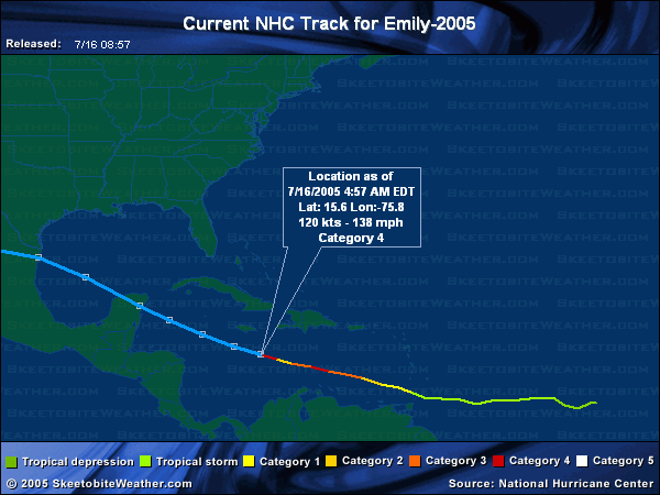
11PM Update (Friday)

After undergoing an eyewall replacement cycle this afternoon, resulting in a 20mb jump in pressure and 30mph reduction in winds, Emily has rapidly intensified once again. As of the 11pm advisory, winds had increased again to 135mph; since then, recon reports indicate the pressure has fallen to 954mb. This makes Emily a dangerous category 4 hurricane once again. Another eyewall replacement cycle is likely in its near future, probably sometime during the early morning hours tomorrow. Clark has more analysis and forecast reasoning in the met. blogs below.
Original Update
Overnight, Emily strengthened again, to a category four storm. It formed a relatively small eye (around 6 nautical miles) and deepened. Right now it appears to be going through an eyewall replacement cycle, which may allow it to deepen a little more after it is complete.


Hurricane warnings are up for the island of Jamaica, as the storm will pass very close to the island, most likely just to the southwest, but the cone of error potentially puts it crossing the island as well. Once again, folks in Jamaica must prepare for a major hurricane.
Beyond Jamaica it looks as if Emily may clip the Yucatan peninsula, cross into the bay of Campeche, and eventually landfall likely in Mexico just south of the Texas border. Because of the possible error with this storm, folks along the coast of Texas to much of the eastern coast of Mexico, and the Yucatan, including Cancun need to keep a very close watch on this storm.
It will be near or over the Yucatan Monday, and over the Bay of Campeche Monday night, and tuesday, and nearing the mainland coast of Mexico or Texas Wednesday. Florida is in the clear, as is most of the Gulf coast west until Texas. However, even then the more likely scenario is into Mexico. Watch it, of course, but the ridge above it is strong and will likely keep it on a more westerly track.
Forecast models aren't being all that consistant with the exact track that far out (into the landfall in Texas or second in Mexico) So folks from Houston/Galveston southward well into Mexico will need to watch this.
Event Related Links
StormCarib hurricane reports from observers in the Islands - Jamaican StormCarib Reports
Caribbean Island Weather Reports
Jamaican Meteorological Service
Color Sat of Gulf (Animated)
RAMSDIS high speed visible Floater of Storms
Emily
Visible/IR Floater of Emily with storm track Overlays
Aruba Radar
Animated Model Plot of Emily
Model Plot Graphic from the South Florida Water Management District of Emily
Emily Spaghetti Model from boatus
Weather Underground Model Plots for Emily
QuikScat Image of Emily
Dennis and emily plotted on a google map
Area east of Emily (99L)
Animated Model Plot of Area East of Emily 99L
Model Plot of Area East of Emily 99L (Graphic from the South Florida Water Management District)
Edited by SkeetoBite (Sat Jul 16 2005 12:45 PM)
|
HumanCookie
Verified CFHC User

Reged:
Posts: 17
|
|
WoW! Small but yet dangerous. 
|
VandyBrad
Weather Hobbyist

Reged:
Posts: 80
Loc: Bryan, TX
|
|
Yes it is small, which brings up a question I've often thought about. Does the size of the storm affect the intensification... namely the rate of intensification? Essentially, I could envision two storms of identical strength in similar SST and shear environments but one is much larger than the other. Does the smaller storm intensify more rapidly than the larger storm since it has less "area" to distribute the energy it gains from the sea and can thus distribute the energy more rapidly? Just curious...
--------------------
Brad Shumbera
|
GuppieGrouper
Weather Master
Reged:
Posts: 596
Loc: Polk County, Florida
|
|
My question is if the models are verifying out far enough now to be absolutely sure this can not make another turn. I keep thinking about Irene, and . We are now at the time where a sudden change would Catch Florida off Guard. I know that the question sounds stupid, but the declarations are sounding so final that it is a little worrisome. I know people have to take a stand from time to time. I hope that the storm spins itself out before it does anything more than give Texas much deserved rain.
--------------------
God commands. Laymen guess. Scientists record.
|
rmbjoe1954
Weather Master

Reged:
Posts: 427
Loc: Port Saint Lucie, Florida, USA
|
|
In meterology there are no 'absolutes'. However, with this ridge entrenched in the Gulf, I can almost be certain this thing will not do a 'Charlie' on Florida or anywhere in the eastern GOM.
--------------------
________2023 Forecast: 20/10/5________
There is little chance that meteorologists can solve the mysteries of weather until they gain an understanding of the mutual attraction of rain and weekends. ~Arnot Sheppard
|
Wingman51
Weather Guru

Reged:
Posts: 126
Loc: Orlando, FL
|
|
OK - - So Emily heads South of Fla, maybe makes a turn to the NW in the GOM - - What is the status of what we were calling 91L - - Fish Spinner?? 
|
VandyBrad
Weather Hobbyist
Reged:
Posts: 80
Loc: Bryan, TX
|
|
Wingman, I think it is 99L and I think things are still up in the air.
--------------------
Brad Shumbera
|
Frank P
Veteran Storm Chaser
Reged:
Posts: 1299
|
|
Yeah I agree, I highly doubt a Charlie track could come of this, but I would not rule out that LA could not be impacted down the line with this, weather dynmanics are hare to pinpoint that far out.... margin of error is quite large from 5 days out and I've seen many times when areas were outside the 'Cone" from 5 days out, only to be severly impacted from a tropical cyclone... my opinion only....
Per NWS discussion out of NOLA they believe the models are still under estimating the strength of the trough, which "could" result in even more shifts to the right over time...
http://www.srh.noaa.gov/mob/productview.shtml?pil=LIXAFDLIX&version=0
at the moment anywhere in the GOM from lower Mexico to LA could be affected from this storm
|
MadDog
Weather Hobbyist
Reged:
Posts: 51
Loc: DeBary, Florida
|
|
Joe B. thinks that a portion of 99L will spin off NE and a bigger portion may continue on W under the ridge.
|
Biowatch
Verified CFHC User

Reged:
Posts: 19
Loc: Massachusetts
|
|
Very new to site, although not to weather watching! Have concerns regarding daughter doing charitable work in the Yucatan. Working between Merida, Izamal and Puerto Morelos Beach. Watched carefully, but am concerned about Emily's track. Does anyone know the topography of this part of the Yucatan? ..ie..is it prone to mudslides, etc? Hoping for a slight turn north. Any signs of this? thanks.....
|
Rasvar
Weather Master

Reged:
Posts: 571
Loc: Tallahassee, Fl
|
|
With the speed of this system and the current dynamics, I see an almost virtual certainty that the system will not turn towards Florida. My concern would be from Galveston down into Mexico. Texas could be in big danger if Emily misses the Yucatan. However, I think the Yucatan is in for a pretty big hit.
This storm, like , is right in the 's wheelhouse. Well defined steering pattern, good storm structure. Absolutely no reason to doubt their forecast on this system.
--------------------
Jim
|
Beaumont, TX
Storm Tracker
Reged:
Posts: 318
|
|
The track has shifted northward. I am wondering if it could shift even further north and if the upper Texas coast might need to monitor the storm. We are about 90 miles from Houston.
|
rmbjoe1954
Weather Master
Reged:
Posts: 427
Loc: Port Saint Lucie, Florida, USA
|
|
Everyone in the western GOM (west of Louisianna) should monitor the progress of Emily. You will get a better picture of where Emily goes by Sunday.
--------------------
________2023 Forecast: 20/10/5________
There is little chance that meteorologists can solve the mysteries of weather until they gain an understanding of the mutual attraction of rain and weekends. ~Arnot Sheppard
|
Rasvar
Weather Master
Reged:
Posts: 571
Loc: Tallahassee, Fl
|
|
The other thing to add about last year is that none of the storms that hit Florida were a surprise. Many models had all these storms hitting Florida at days out from landfall. Even when they weren't, they were either close or showing a possibility. I remember seeing , and Jeanne all threatening Florida well in advanced on the computer models. Even Jeannes loop was caught by many of the models. Not consistently; but the hint was there. There is not even a sniff of the models showing Emily as a threat to Florida. I feel safe in saying this will not be a Florida storm unless it gets out to near Texas and pulls a 180 from there.
--------------------
Jim
|
Rasvar
Weather Master
Reged:
Posts: 571
Loc: Tallahassee, Fl
|
|
Quote:
The track has shifted northward. I am wondering if it could shift even further north and if the upper Texas coast might need to monitor the storm. We are about 90 miles from Houston.
I would keep a very close eye on this system and at least begin making sure I have my supplies available, if needed. Easier to get them now then when the stores get swampped.
--------------------
Jim
|
Rasvar
Weather Master
Reged:
Posts: 571
Loc: Tallahassee, Fl
|
|
I wish I could help you on that, Biowatch. I am not familiar with the areas geography.  Off hand, I do not recall mudslides being a problem in that area. I am far from certain though. My personal feelingafter looking at things is that Emily will hit the Yucatan. I do not think she is going to shoot the gap. Take my comments with not just a grain of salt; but a salt block, though. Off hand, I do not recall mudslides being a problem in that area. I am far from certain though. My personal feelingafter looking at things is that Emily will hit the Yucatan. I do not think she is going to shoot the gap. Take my comments with not just a grain of salt; but a salt block, though.
--------------------
Jim
|
Biowatch
Verified CFHC User
Reged:
Posts: 19
Loc: Massachusetts
|
|
Thanks for reply, Rasvar. I don't know the geography there either. I read that the town named "Izamel" means "city of hills". That spells trouble for mudslides to me.Hopefully, if it does hit the Yucatan, it will be fast moving and not dump quite as much rain. Speed seems pretty high right now.....hopefully it does not slow down....Have not seen any eye on radar this morning....
|
AgentB
Weather Guru

Reged:
Posts: 188
Loc: Winter Park, FL
|
|
Quote:
Does the size of the storm affect the intensification... namely the rate of intensification? Essentially, I could envision two storms of identical strength in similar SST and shear environments but one is much larger than the other. Does the smaller storm intensify more rapidly than the larger storm since it has less "area" to distribute the energy it gains from the sea and can thus distribute the energy more rapidly? Just curious...
I would agree with the idea that a smaller storm would intesify more rapidly than a larger one. If you think about some of the strongest hurricanes in history(Camille/Andrew/etc), they weren't very large storms. More specifically their eyes weren't very large. I think it would take less heat/energy to build, maintain and strengthen a smaller stormso it's a bit easier to become very strong.
One thing I've been thinking of is what inhibits a storm's growth. Obviously cooler ocean temps, dry air, etc. will reduce a storm's strength/size. However, does a storm ever reach a point where it will not grow anymore even if it's in a favorable environment? Almost as if the way it formed and grew can determine how big it will eventually become, and for some reason it won't get past a certain point? Or is it always inhibited by the water temps/surrounding air/etc. and not much else?
--------------------
Check the Surf
|
cjzydeco
Weather Guru

Reged:
Posts: 120
Loc: Sebastian, FL
|
|
Biowatch... I have never been to the Yucatan, but from years in school studying geology, I do know that the Yucatan is a plateau composed mostly of limestone (very porous) and is an area of very low relief with elevations varying by less than a few hundred meters (about 500 feet). Any place that gets an exorbitant amount of rain can be prone to flooding, but true "flash floolding" (rushing torrents of raging flood waters) is less common in flat areas like Florida and places like the Yucatan. Thus, a hurricane in the Yucatan probably would not cause the mud sildes that we saw with Georges a few years back (I think that was it).
However, the fact that the Yucatan is low-lying and flat means the coastal areas may be prone to storm surges that reach several miles inland, as in Florida. Also, because the area is so flat and low, heavy rainfall won't really have any where to run off, and low areas may remain flooded for several days or weeks until the water can soak in to the or drain off.
Thus, flooding is likely going to be problem if Emily hits the Yucatan, but not necessarily mudslides. Just some thoughts based on what I know about the geology. But don't take my word for it, okay?
--------------------
Lat/Lon: 27.8, -80.5
Frances '04, Jeanne '04, Wilma '05, Ernesto '06, Faye '08
Edited by cjzydeco (Fri Jul 15 2005 02:08 PM)
|
Margie
Senior Storm Chaser

Reged:
Posts: 1191
Loc: Twin Cities
|
|
Good morning all.
Well no huge surprises this morning, seeing that Emily reached Cat 4 status and is likely in an .
Emily seems to have become less compact overnight. What, if any, significance is there to this change?
--------------------
Katrina's Surge: http://www.wunderground.com/hurricane/Katrinas_surge_contents.asp
|


 Threaded