MikeC
Admin
Reged: Sun
Posts: 4543
Loc: Orlando, FL
|
|
9AM Update
Isidore down to a tropical storm, still meandering over land. I think the threat of a major on the US Coast has gone down, but not far enough to be comfortable. Isidore may never make it back over the open water. I'll wait until the 11AM advisory set to make the next real update.
11PM Update
Isidore moved south onto the Yucatan peninsula and is now stalled near Meridia. Dumping tremendous amounts of rain... after plenty of wind and probably storm surge. I believe it has gone as far south as it will. Now it will hang out and eventually move back over the water. I do think it'll restrengthen and head north still.
It has weakened, and may a bit more first.... Still watching and waiting, and still nowhere in the gulf is in the clear yet.
8PM Update
Isidore move totally inland... and is moving southwest. The storm is still strong. A bit of a wildcard was thrown into the forecast. More later...
Original Update
Isidore is jogging a bit south now. But not as west as much, which may make things interesting. It's a borderline Cat 3/4 system, and the hurricane center is keeping it a 3 for now due to being so close to land.
Now it's time to eat a bit of crow and admit it'll probably make landfall briefly (as in very... I doubt the entire eye will make it over) on the Yucatan from the north side. (Rare) Then it's still anyone's guess. Yes Mexico seems more likely now, but it isn't as likely as you may think. It still has one more good shot at getting pulled to the north later. Still isidore will be with us for a bit.
The models are still all over, but my previous guess of landfall between TX/LA and FL/AL borders stands unchanged. All of the gulf still has to remain on alert. I just can't rule anything out at this point. Mexico is a close second to the TX/LA - FL/AL call.
Confidence in any of these models or landfall calls:
code:


forget it) 0 1 2 3 4 5 6 7 8 9 10 (sure thing)


          [--*-------------------]
Ie almost nil.
Keep watch folks, this tracking ride's steepest hill has yet to be climbed.
Too add yet another oddity, the mass of clouds east of Isidore, south of Cuba looks like it may becoming its own entity.
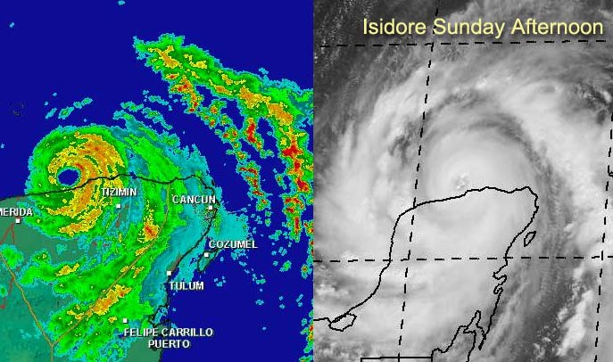
Earlier BillD gave me some animated cancun radar loops from last night you can find them here and also here.
TD#13 is moving almost too quickly for it to develop much soon, and may fall apart a bit, although I think it'll regain itself and become lili sometime tomorrow.
Cancun, Mexico Radar
NRL Monterey Marine Meteorology Division Forecast Track of Active Systems (Good Forecast Track Graphic and Satellite Photos)
NASA GHCC Interactive Satellite images at:
North Atlantic Visible (Daytime Only), Infrared, Water Vapor
Some forecast models:
NGM, AVN, MRF, ETA ECMWF
DoD Weather Models (NOGAPS, AVN, MRF)
AVN, , , , , UKMET
Other commentary at Mike Anderson's East Coast Tropical Weather Center, Robert Lightbown/Crown Weather Tropical Update Accuweather's Joe Bastardi, Hurricane City Weather Audio Broadcast Network - Live Audio from Jim Williams and Barometer Bob , mpittweather , Tropical Weather Watchers.Com (JasonM) Gary Gray's Millennium Weather, Barometer Bob's Hurricane Hollow, Snonut, Ed Dunham and Jason M in our Storm Forum Even more on the links page.
- [mike@flhurricane.com]
|
Kevin
Weather Master

Reged: Fri
Posts: 524
Loc: EC Florida
|
|
Isidore: No change of thought on the situation.
TD#13: Looks a little better this afternoon...11 AM discussion might have missed something, which was pointed out on the 2 PM TWD. It said an LLC could be hidden under the convection. Probably will slow down tomorrow and develop quickly thereafter.
Kyle: Looks like crap.
The Saints will be 2-1 today, of course! 
Kevin
|
Anonymous
Unregistered
|
|
models up date uk / noraps /gfdi /cmc /avn all hit L/A with in 100 niles of each other
|
squirralee
Weather Hobbyist

Reged: Wed
Posts: 80
Loc: Mims, Florida
|
|
Kevin,
Where did you find the 2PM TWD on #13? That info wuld be greatly appreciated. Thanks
|
Anonymous
Unregistered
|
|
Wow!!! a near consensus of all of the models. And all of them east of previous forecast. Still think theEastern LA to NW FL landfall is looking pretty good. Maybe even a double strike. First in SE LA and then around the AL,FL line. Four landfalls for one hurricane. Pretty impressive.
|
squirralee
Weather Hobbyist
Reged: Wed
Posts: 80
Loc: Mims, Florida
|
|
Kevin,
Nevermind I found it DUH!!!! LOL
|
Kylein Pensacola
Unregistered
|
|
this is the most the models have agreed in a while. but in 12 hours the track will shift west again maybe. but what the models are saying is what i have been thinking for awhile now. an no i am not wishcasting that the storm comes my was but i aint ever been in a hurricane an after reading some stories on the board i dont exactly want to be in one. keep up the good work everyone
|
Anonymous
Unregistered
|
|
Look at the cancun radar it will take long as hell to load but the eye is partially over land which means i guess the storm has temporarily made landfall. very intresting could this mean anything?
|
Anonymous
Unregistered
|
|
What is the agreement of models everyone is speaking of I still see them spread out am I missing something? BarryB.
|
HanKFranK
User

Reged: Mon
Posts: 1841
Loc: Graniteville, SC
|
|
temporary diversion.. see the small swirl near 33/72 headed wnw? peculiar.. perhaps all that was to come of bastardi's original pinwheel idea.
isidore has nudged its eye right to the coast. recon found the pressure still at 935mb, but flight level winds still dont extrapolate to cat 4 surface winds. still sort of annoying they arent calling it that way.
upper low off the eastern seaboard is troughing and pulling out.. so ridging should be building from here on. northward component should appear tomorrow or tuesday to isidore.
kyle isnt having a very good day.
td 13.. tough call. the center dash ahead is probably the main center.. but the system is obviously trying to hold on. there is an small upper trough axis over the islands that is causing shearing ahead.. then beyond it northerly shear from isidore's outflow begins. TD 13 is pretty disorganized.. but if the slowing of forward motion takes place then it should become a tropical storm.
if the system survives i'd expect it to stay south of puerto rico and possibly hispaniola too.
wave near 32w is getting sheared.. some of its energy is going ne, some should continue westward. new wave coming off as well, nothing organizing out there.
HF 2003z22september
|
Anonymous
Unregistered
|
|
Frank what do you think of the move to the coast of the Yucatan of Isidore?
Temporary or it is a true landfall?
|
WXMAN RICHIE
Weather Master

Reged: Mon
Posts: 463
Loc: Boynton Beach, FL
|
|
Looks like the eye is headed right for the city of Merida, Mexico. Winds currently west at 46 mph as of the 4:10 EDT observation. Pressure 29.03". Here is a link to Merida hourly observations. http://www.wunderground.com/global/stations/76644.html
--------------------
Another typical August:
Hurricane activity is increasing and the Red Sox are choking.
Live weather from my backyard:
http://www.wunderground.com/weatherstation/WXDailyHistory.asp?ID=KFLBOYNT4
|
Ed Dunham
Former Meteorologist & CFHC Forum Moderator (Ed Passed Away on May 14, 2017)
Reged: Sun
Posts: 2565
Loc: Melbourne, FL
|
|
Regarding the pressure vs wind, there must be a new Murphy's Meteorological Law this year: The lower the pressure the lighter the wind. Its called the Law of Diminishing Returns (stolen from recent trends in the Stock Market)  Sorry Hank - couldn't resist. Actually it sure seems odd to me as well - that, and three straight recons last night with the same max flight level wind of 109kts?! Sorry Hank - couldn't resist. Actually it sure seems odd to me as well - that, and three straight recons last night with the same max flight level wind of 109kts?!
Buried somewhere in about the last 1,000 posts is a gem from Kimster with a listing of the strongest hurricanes of record. Kim do you have a link to that list? It would be a great addition to the History Forum and I'd like to see what the winds were like in storms with similar pressure.
Cheers,
ED
|
WXMAN RICHIE
Weather Master
Reged: Mon
Posts: 463
Loc: Boynton Beach, FL
|
|
Hi Ed,
Here is the link.
http://www.nhc.noaa.gov/pastint.html
--------------------
Another typical August:
Hurricane activity is increasing and the Red Sox are choking.
Live weather from my backyard:
http://www.wunderground.com/weatherstation/WXDailyHistory.asp?ID=KFLBOYNT4
|
Anonymous
Unregistered
|
|
Everyone go an read what Joe Bastardi wrote on his post. Kinda wierd what he said was gonna happen happens now lets see what Izzy does after this. I agree with Joe on this one.
|
canman32
Verified CFHC User
Reged: Sat
Posts: 11
Loc: Crstview Florida
|
|
weather channel says track after 48 hours is northwest and possible north/
|
Anonymous
Unregistered
|
|
whaT DOES ALL THAT DRY AIR IN SOUTH TEXAS MEAN COMING TO THE GULF
|
joepub1
Storm Tracker
Reged: Wed
Posts: 240
Loc: Jacksonville,Fla
|
|
Just an idea about this landfall. If you go look at the current water vapor image, that pulse of energy that is moving through the Great Lakes is a) at it's lowest point as it crosses the US b) right above, as far as 89-90W, Izzy. Watch the loop and you will see as it gets closer to him he turns more to the SW, when it's right above him he went almost due south.
One thing it did for sure was slow his westward progress down to almost nothing, which keeps leaving that door open a little to wide for my taste. The Yucatan Penn. may take some starch out of his shorts, but it's not his final resting place.
|
WXMAN RICHIE
Weather Master
Reged: Mon
Posts: 463
Loc: Boynton Beach, FL
|
|
5 p.m. update greatly increases the risk to the U.S. Track much more to the right/north now after 48 hrs. Speed also will increase and storm could be a cat. 4. Everyone from Texas to the Fl. panhandle better start to take this seriously.
--------------------
Another typical August:
Hurricane activity is increasing and the Red Sox are choking.
Live weather from my backyard:
http://www.wunderground.com/weatherstation/WXDailyHistory.asp?ID=KFLBOYNT4
|
Kevin
Weather Master
Reged: Fri
Posts: 524
Loc: EC Florida
|
|
Yes, indeed Richie. Here is the link to the new forecast discussion:
http://www.nhc.noaa.gov/text/MIATCDAT5.html
When is the last time you saw a discussion on the track that long? Anyways, the US threat is on. The discussion also mentions the storm is already above-average in size and that it will be even larger at 72 hours. The effects of Isidore could be felt for hundreds of miles--no kidding here. The time to prepare is now folks. Don't wait until late this week when the storm is getting ready to bear down.
Also, it looks like TD#13 has survived. It's in an area of some stronger shear, but it will be out of this in 24 hours. This could well be a significant cyclone eventually as well. For now we need to focus on Isidore, though.
Kevin
|


 Threaded


