HanKFranK
User

Reged:
Posts: 1841
Loc: Graniteville, SC
|
|
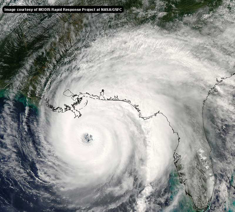
okay.. figured it would go just a little inland. NOW what is this thing doing? going mitch on us?
HF 2345z22september
|
ShawnS
Storm Tracker
Reged:
Posts: 226
Loc: Pearland,Tx
|
|
The possibility I see in this is that it continues to move more less south which moves it further inland. I believe Joe B. thought that it would go inland BUT that it wouldn't go this far inland and continue to go further inland. Izzy may just decide to follow a southerly track and die out in the middle of the Yucatan. He may get too far southward for the trough to pick him up. The point Joe B. was saying is that Izzy would emerge back over the BOC, but if he keeps going south he will never get there.
|
Anonymous
Unregistered
|
|
IZZY IS A GONER
|
joepub1
Storm Tracker
Reged:
Posts: 240
Loc: Jacksonville,Fla
|
|
My most favorite model in the world, the 18Z, actually took this little trek into account. It shows that when Izzy starts back toward the west, it will be NW, not W or SW. But then I hate this model with a passion as far as it's performance with Izzy. Where in the world is 55.4N, 77.6W? Canada? 
|
Frank P
Veteran Storm Chaser
Reged:
Posts: 1299
|
|
Justin, the eye of Camille went inland at Waveland/Bay St Louis MS area... It was an extremely small in diameter ~ 8 miles or so...
That's about 20 miles to the west of Biloxi, Gulfport, Long Beach, Pass Christian all in the extremely violent NE quadrant of the storm... anemometer at Keesler AFB (Biloxi) failed after recording gusts in excess of 200 mph....
Tide estimates of 26 feet just east of the eye and 22 feet at my house ... which is 20 feet above sea level... and is one of the highest elevations along the beach on the MS coast... I live next to Edgewater mall on the east side.... the house I was actually staying in during the storm had 5 feet of water... should have stayed home on the beach...
Since then I have totally rebuilt my house making it even much stronger than the one that actually survived Camille... the only thing that would make me evacuate is if the tidal surge exceeds 20 feet... then I'm a gone pecan... I just don't see that happening... not even with a strong Cat 4... I've been through every storm that has hit the coast since Betsy of 65....
Why do I stay, its personal and leave it at that....But let me emphasize that I certainly don't recommend staying for a major storm for ANYONE.... my family will evacuate for any storm with winds above 120 mph that hits to our west... and I will evacuate if the tidal surge is expected to exceed 20 feet...
but thanks for asking......
|
Kevin
Weather Master

Reged:
Posts: 524
Loc: EC Florida
|
|
For all saying that Isidore will vanish over the Yucatan, I beg to ask you one question. Has the eye gotten raged looking on satellite imagery? Looks as if it has improved slightly to me. Feel free to debate this tonight. I still think this all has major implications down the road.
It'll be real interesting to see Isidore in the morning. My next tropical analysis should come tomorrow afternoon.
Here's a good one: Good night to all....sleep tight....don't let the hurricanes bite! Hehehehehe
Kevin  
|
cappycat
Verified CFHC User
Reged:
Posts: 16
Loc: Raceland, LA
|
|
mr. jimmy...hey neighbor! Andrew was a bunch of fun, wasn't he? Like a root canal!!! Never want to do that again.
I don't like that Houma - New Iberia option at all. Just talked with my dad about izzy and he speculated it would be coming, oh, right there...pointing between the two big pecan trees in the front yard. We have friends up in McComb...hope they don't mind all my cats 
|
WXMAN RICHIE
Weather Master

Reged:
Posts: 463
Loc: Boynton Beach, FL
|
|
Maybe the storm will move SE and back into the Caribbean? No one is expecting that!!!! Steve, thanks for Ricky Williams, Dolphins 3-0, best team in Florida.  Saints best team outside of Florida. See you in the Superbowl. Bucs will be 1-2 after tomorrow. Saints best team outside of Florida. See you in the Superbowl. Bucs will be 1-2 after tomorrow.
--------------------
Another typical August:
Hurricane activity is increasing and the Red Sox are choking.
Live weather from my backyard:
http://www.wunderground.com/weatherstation/WXDailyHistory.asp?ID=KFLBOYNT4
|
joepub1
Storm Tracker
Reged:
Posts: 240
Loc: Jacksonville,Fla
|
|
THE EYE OF ISIDORE HAS BEEN MOVING TOWARD THE SOUTHWEST NEAR 8 MPH...13 KM/HR...OVER THE PAST FEW HOURS. A SLOW WEST-SOUTHWESTWARD
MOTION IS EXPECTED FOR THE NEXT 24 HOURS. ON THIS TRACK...THE CENTER OF ISIDORE WILL REMAIN OVER THE NORTHWEST YUCATAN PENINSULA AT LEAST THROUGH EARLY MONDAY.
OK. Maybe I missed something at 5?
Anything to cover their rear end, I guess. 
|
WXMAN RICHIE
Weather Master

Reged:
Posts: 463
Loc: Boynton Beach, FL
|
|
Updated: 5:55 PM CDT on September 22, 2002
Observed at Merida, Mexico
Temperature 77° F
Humidity 100%
Dew Point 77° F
Wind WNW at 47 mph
Wind Gust 78 mph
http://www.wunderground.com/global/stations/76644.html
--------------------
Another typical August:
Hurricane activity is increasing and the Red Sox are choking.
Live weather from my backyard:
http://www.wunderground.com/weatherstation/WXDailyHistory.asp?ID=KFLBOYNT4
|
canman32
Verified CFHC User
Reged:
Posts: 11
Loc: Crstview Florida
|
|
It all depends on when it gets picked up toward the north. If it moves west or sw then I see a western louisianna hit, if it gets picked up before it heads west then I see a New orleans to Florida panhandle hit.
Probally wont know till tomorrow at the earliest.
|
Anonymous
Unregistered
|
|
In response to HankFranks scenario:
What if the hurricane continues to go south and then turns east off the caribbean side of the Yucatan. It might emerge a cat one and then still end up going in between tampa and Cedar Key. Especially if that expected trough meets it there. That would be very interesting. But, I am not forecasting it. As for Lilie she and Kyle should go to the fishes together! I am about worn out from watching this TD#10!
|
meto
Weather Guru
Reged:
Posts: 140
|
|
as i said earlier would be change in forecast.
|
FlaRebel
Unregistered
|
|
I'm still nervous here in Tallahassee. I've said all along I felt landfall would be between Biloxi and Apalachicola. I'm still sticking to that right now.
|
SirCane
Storm Tracker

Reged:
Posts: 249
Loc: Pensacola, FL
|
|
Opal formed WHILE on top of the Yucatan Peninsula! It's like the only storm in history to have its first advisory while on land.
I'm thinking of an Opal like track right now. This TROUGH IS STRONG folks!!!
--------------------
Direct Hits:
Hurricane Erin (1995) 100 mph
Hurricane Opal (1995) 115 mph
Hurricane Ivan (2004) 130 mph
Hurricane Dennis (2005) 120 mph
http://www.hardcoreweather.com
|
Frank P
Veteran Storm Chaser
Reged:
Posts: 1299
|
|
Well it looks to me that it's still plowing more south than west on the IR loop.... I keep asking myself will it really turn North? I would imagine that since it's so strong and still close to the water, it could survive in decent shape even over land for a extended period of time... I see very little westerly component in its track right now... maybe it will change as forecasted...
I'll say this, the longer it stays over land and drives south, the more likely of a future impact to the central florida area... if it ever decides to make that northerly turn... IMO...
So I would not necessary think that anyone is out of the woods yet...
Oh and another thing... RUN RICKY RUN... as the saints should get another first round draft choice next year if he continues to pile up the yards and he should pending no injuries...I'm a RW fan .... and the trade was great for both teams... both 3-0
|
canman32
Verified CFHC User
Reged:
Posts: 11
Loc: Crstview Florida
|
|
I agree, the Opal comparisons are pretty strong.
|
Domino
Weather Guru
Reged:
Posts: 191
Loc: Makati City, Philippines
|
|
They are forcasting a BIG drop in temperature for the midwest from this thing...I'm assuming its the same trough that should be picking up this storm. My eyes right now are on TD13...should make things interesting in a few days. I don't want us to all be watching Izzy and forget this soon-to-be potent storm sneaking up behind us. True its not nearly as big just don't want us to forget what we'd be talking about it Izzy wasn't here.
|
joepub1
Storm Tracker
Reged:
Posts: 240
Loc: Jacksonville,Fla
|
|
Frank, it looks like your ship may not be sinking afterall.
I knew they made you a stormtracker for some reason.......

|
Joe
Storm Tracker
Reged:
Posts: 216
Loc: St.Petersburg,FL
|
|
Could it be? Taking look at latest black/white IR loop set over center at 100% shows it possibly moving sse,looping? This is looking very intresting.
|


 Threaded


