Hugh
Senior Storm Chaser
Reged:
Posts: 1060
Loc: Okaloosa County, Florida
|
|
Quote:
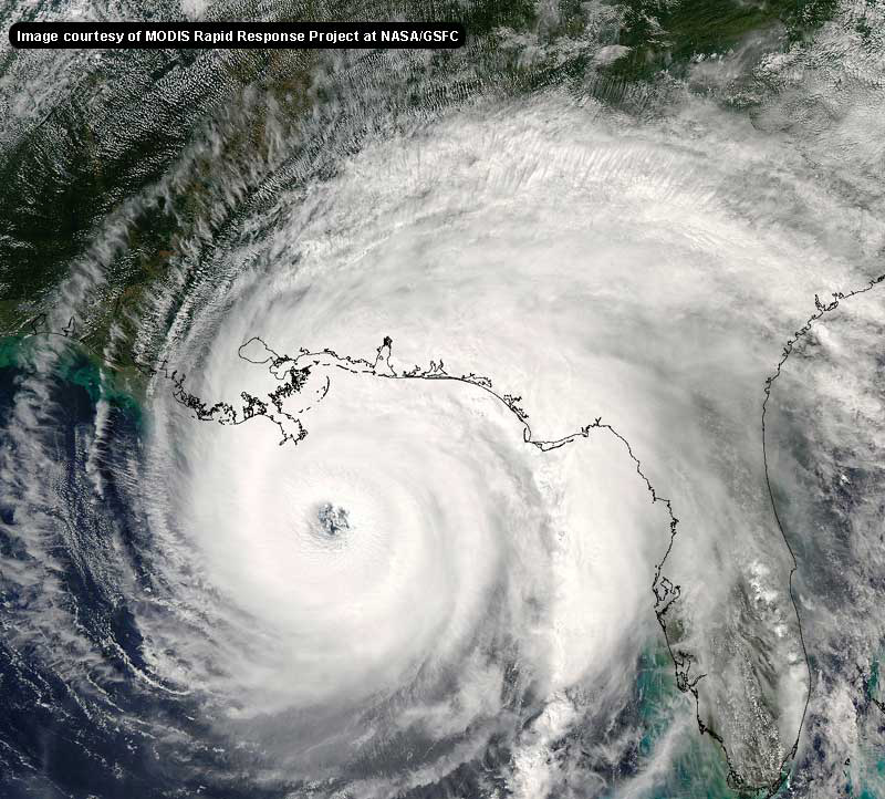
Based on radar a few hours ago, the eyewall replacement cycle was going on replacing a tiny, 9 NM eye with a larger one about double the radius.
However, looking at IR, WV, and Visible it appears this new eye has formed, and a 2nd, giant-eye eyewall replacement cycle has begun more then doubling the recently formed eye. Can anyone confim this? The visible is picking up a new circular pattern outside the central eye, convection (IR) and WV show a nearly completely inactive zone between the new eye and the even newer forming eyewall.
I wish this thing was inside radar range so we could see for sure.
Source: SSD Floater 1
Again, can anyone confirm what I'm seeing?
I see the same thing. The WV makes the eye look VERY large. I can see a bit of a WNW trend on the WV but not on visible of IR. If the new eye compresses to the north instead of the south that could signal a change in motion (couldn't it?). Still looks on WV like someone punched 's upper left corner in.
--------------------
Hugh
Eloise (1975) - Elena and several other near misses (1985) - Erin & Opal (1995) - Ivan (2004)
|
dkpcb
Registered User
Reged:
Posts: 6
Loc: Panama City Beach Florida
|
|
If Jason is leaving Panama City Beach,
we must be out of danger here, good news
for us.
But we still keep on eye on this storm, if this storm
turns to the east, channel 7 will be without there
main man (Chief Meteorologist) and we have to watch channel 13.
We are very supprised about Jason leaving.
Hopefully won't turn our way.
Travel safely, Jason!
Who ever will end up in 's path you are in our prayers !
DK
|
Storm Hunter
Veteran Storm Chaser

Reged:
Posts: 1370
Loc: Panama City Beach, Fl.
|
|
URNT12 KNHC 271725
VORTEX DATA MESSAGE
A. 27/1651Z
B. 24 DEG 22 MIN N
85 DEG 15 MIN W
C. 700 MB 2653 M
D. N/A
E. N/A
F. 220 DEG 96 KT
G. 125 DEG 29 NM
H. 949 MB
END
URNT12 KNHC 271725
VORTEX DATA MESSAGE
A. 27/1651Z
B. 24 DEG 22 MIN N
85 DEG 15 MIN W
C. 700 MB 2653 M
D. N/A
E. N/A
F. 220 DEG 96 KT
G. 125 DEG 29 NM
H. 949 MB
NOAA3 1312A OB 11
--------------------
www.Stormhunter7.com ***see my flight into Hurricane Ike ***
Wx Data: KFLPANAM23 / CW8771
2012== 23/10/9/5 sys/strms/hurr/majh
Edited by Storm Hunter (Sat Aug 27 2005 05:22 PM)
|
SirCane
Storm Tracker

Reged:
Posts: 249
Loc: Pensacola, FL
|
|
I'm not comfortable about this. moved eastward before landfall. Just afraid something like that could happen, which is why this area is in that cone. I do know some nasty weather is on the way as it pushes North. Those are some nasty outer rain bands. Just ask the people in the keys!
--------------------
Direct Hits:
Hurricane Erin (1995) 100 mph
Hurricane Opal (1995) 115 mph
Hurricane Ivan (2004) 130 mph
Hurricane Dennis (2005) 120 mph
http://www.hardcoreweather.com
|
MikeC
Admin
Reged:
Posts: 4544
Loc: Orlando, FL
|
|
Post deleted by MikeC
|
SirCane
Storm Tracker

Reged:
Posts: 249
Loc: Pensacola, FL
|
|
http://maps.wunderground.com/data/images/at200512_model.gif
Look how close together these models are. Go by those N.O. may be spared. Looks more like a Mobile/Boloxi hit if you go by that. People should not let their guard down anywhere up here.
--------------------
Direct Hits:
Hurricane Erin (1995) 100 mph
Hurricane Opal (1995) 115 mph
Hurricane Ivan (2004) 130 mph
Hurricane Dennis (2005) 120 mph
http://www.hardcoreweather.com
|
Storm Hunter
Veteran Storm Chaser

Reged:
Posts: 1370
Loc: Panama City Beach, Fl.
|
|
models are moving east again...
just have a bad feeling about southern Miss... MS/AL would be my landfall right now.....
--------------------
www.Stormhunter7.com ***see my flight into Hurricane Ike ***
Wx Data: KFLPANAM23 / CW8771
2012== 23/10/9/5 sys/strms/hurr/majh
Edited by Storm Hunter (Sat Aug 27 2005 05:40 PM)
|
ralphfl
Weather Master
Reged:
Posts: 435
|
|
I still hold to what i said last night and early today in that this is will ALA and be a cat 3 maybe a low cat 3 even when landfall.This is setting up this way for 2 reasons IMO #1 the models have tranded back towards Mobile and #2 there looks to be alot of shear in the forcast before landfall,and since this torm is going to be slow moving i see a Opal type storm in the making.
Now will this happen? no idea it is what i am feeling now looking at the models and the projected shear.
But the says poss a 4 at landfall so by all means listen to them.
|
Storm Hunter
Veteran Storm Chaser

Reged:
Posts: 1370
Loc: Panama City Beach, Fl.
|
|
URNT12 KNHC 271734
VORTEX DATA MESSAGE
A. 27/17:15:50Z
B. 24 deg 25 min N
085 deg 15 min W
C. NA mb NA m
D. 60 kt
E. 310 deg 019 nm
F. 040 deg 083 kt
G. 314 deg 038 nm
H. 950 mb
I. 9 C/ 3657 m
J. 18 C/ 2436 m
K. 18 C/ NA
L. OPEN SE
M. C50
N. 12345/NA
O. 0.02 / 2 nm
P. AF306 WX12A 01 OB 05
MAX FL WIND 83 KT NW QUAD 17:05:10 Z
MAX FL TEMP 21 C, 309 / 16NM
OUTER EYE ON RADAR 50 NM DIA OPEN SE.
INNER EYE 40% COVERAGE SSW - SE
--------------------
www.Stormhunter7.com ***see my flight into Hurricane Ike ***
Wx Data: KFLPANAM23 / CW8771
2012== 23/10/9/5 sys/strms/hurr/majh
|
Hugh
Senior Storm Chaser
Reged:
Posts: 1060
Loc: Okaloosa County, Florida
|
|
Quote:
models are moving east again
Do you mean MORE east than the 8am models went? It looks now on the VIS and WV loop that is definately pinched in the last image - elongated north/south, which if I'm not mistaken is a sign that a northward motion could be imminent.
Update: Latest pressure is up to 950, another MB from the last reader and 10 MB from the lowest level this morning. That's a bit much for an , isn't it?
--------------------
Hugh
Eloise (1975) - Elena and several other near misses (1985) - Erin & Opal (1995) - Ivan (2004)
Edited by Hugh (Sat Aug 27 2005 05:43 PM)
|
Margie
Senior Storm Chaser

Reged:
Posts: 1191
Loc: Twin Cities
|
|
Good morning (yes I'm a sleepyhead).
Looks like the southerly movement has stopped and that she's in an , and because of that she hasn't gained any overall intensity since 4am, looking at recon. So my guess is that we will be seeing pretty much the status quo for today with strengthening later tonight or tomorrow, at earliest very late afternoon.
There must be a reason the winds didn't catch up before the this morning. It would appear she tried to intensify but something kept the process from completing successfully, and whatever that is, is still holding her back.
Remember how Emily "tripped" and fell apart just a half day before hitting Cozumel? That was definitely something different going on in that particular case, but in general there seem to be many processes that haven't been identified yet that affect intensification, as we learn more about these complex storms.
--------------------
Katrina's Surge: http://www.wunderground.com/hurricane/Katrinas_surge_contents.asp
|
bn765
Weather Hobbyist
Reged:
Posts: 60
|
|
So what time does everyone think will start to strenghten again?
|
pcola
Storm Tracker

Reged:
Posts: 344
Loc: pensacola/gulf breeze
|
|
OK..this is why I tell everyone to not look at the line and look at the cone..I just went out here in Gulf Breeze for gas and everyone has let down there guard because they all say its New Orleans..no boarding up or anything..I come back and ALL the models are now east of New Orleans.. EVERYONE from Central LA all the way to Appalachiacola needs to stay alert....NOBODY is out of the woods yet!!!!
--------------------
Erin 95 , Opal 95, Ivan 04, Dennis 05, and that's enough!!!!
|
susieq
Weather Watcher
Reged:
Posts: 49
Loc: Panhandle
|
|
The 1:00 intermediate advisory is out, and it shows the same landfall as before - around NO. THAT track has not shifted east.
http://www.wunderground.com/tropical/tracking/at200512_5day.html
--------------------
Gulf Breeze girl still not over Ivan
|
Hugh
Senior Storm Chaser
Reged:
Posts: 1060
Loc: Okaloosa County, Florida
|
|
Quote:
So what time does everyone think will start to strenghten again?
Got a 12-sided die? Roll it and you'll get as good as guess as anyone could give you I think.
Seriously, I expect it will begin to intensify overnight if not before.
--------------------
Hugh
Eloise (1975) - Elena and several other near misses (1985) - Erin & Opal (1995) - Ivan (2004)
|
Margie
Senior Storm Chaser

Reged:
Posts: 1191
Loc: Twin Cities
|
|
"H. 950 mb
I. 9 C/ 3657 m
J. 18 C/ 2436 m"
Wow 9 deg differential...so is it correct to conclude the pressure will be back below 950mb before too long.
--------------------
Katrina's Surge: http://www.wunderground.com/hurricane/Katrinas_surge_contents.asp
|
pcola
Storm Tracker

Reged:
Posts: 344
Loc: pensacola/gulf breeze
|
|
NHC tracks are not updated on every advisory..only every full advisory, which will be at 4 pm central
--------------------
Erin 95 , Opal 95, Ivan 04, Dennis 05, and that's enough!!!!
|
Hugh
Senior Storm Chaser
Reged:
Posts: 1060
Loc: Okaloosa County, Florida
|
|
Quote:
The 1:00 intermediate advisory is out, and it shows the same landfall as before - around NO. THAT track has not shifted east.
http://www.wunderground.com/tropical/tracking/at200512_5day.html
The TRACK is NOT updated for an intermediate advisory - only the intensity and current position and watches/warnings. The Intermediate Advisory is just that, a public advisory only, not a complete package (which has a forecast and discussion added to it). The track will be updated at 4pm - it may not change but it probably will slightly at least.
ETA:
Every water vapor image I look at makes me think that a turn to the north - not WNW or NW but north - will happen sooner rather than later. appears to my untrained eye to be becoming elongated north/south rather significantly - and appears to not be expanding at all to the west in terms of the overall cloud pattern over the last two hours. Maybe it is just my eyes.
--------------------
Hugh
Eloise (1975) - Elena and several other near misses (1985) - Erin & Opal (1995) - Ivan (2004)
Edited by Hugh (Sat Aug 27 2005 05:54 PM)
|
scottsvb
Weather Master
Reged:
Posts: 1184
Loc: fl
|
|
Im not going to make any predicitions on this cause really right now I cant say where it will go. My speculation forecast isnt out of the woods but looking dim as she never slowed down, also the strong ridge to the N hasnt weakend as much as the forecasted. Anyways that was a speculation forecast.
If I was though between the current Hurricane watch area,,,I would really get started now on the current path shes in cause she hasnt slowed to make the N turn. All the models, and Mets expect a bend towards that area. They might want to extend the current watches up to the Florida line cause Hurricane force winds could exceed 80miles near landfall if its near Biloxi.
scottsvb
|
HanKFranK
User

Reged:
Posts: 1841
Loc: Graniteville, SC
|
|
the latest vortex says the inner eyewall is decaying. that's what it looks like on visible as well.. you can see the gap. diameter of the outer eyewall is 50nm. the inner one is going now, so the outer one should start contracting in. should get a good run of intensification going later this afternoon.
people are talking about the models wavering.. they're actually still pretty well painted on southeastern louisiana, as a previous poster said. almost all of them are btw pascagoula and houma. center of that spread is the delta up to west of biloxi. the official is shaded left from that, almost directly over new orleans.
HF 1751z27august
|


 Threaded


