pcola
Storm Tracker

Reged: Wed
Posts: 344
Loc: pensacola/gulf breeze
|
|
Tropical storm winds 185 miles from the center..thats unreal!!! I don't ever remember that big of a wind field.
--------------------
Erin 95 , Opal 95, Ivan 04, Dennis 05, and that's enough!!!!
|
Storm Hunter
Veteran Storm Chaser

Reged: Wed
Posts: 1370
Loc: Panama City Beach, Fl.
|
|
yeah i saw that, but i am looking for the recon report to confirm that.... all i have found so far is 910mb
she dropped 5mb in two hrs this morning from what i can tell.... went from 915 - 910....and now 908.... pretty good drop i would say in less than 4hrs
Edited by RedingtonBeachGuy (Sun Aug 28 2005 08:41 AM)
|
jr928
Weather Guru
Reged: Fri
Posts: 101
|
|
this storm is taking that ridge and plowing right through. the outflow hits that dry air and just nudges it back. Very bad sign for new orleans. unless that trough digs really deep, that turn is not going to be very noticeable until landfall.
|
Margie
Senior Storm Chaser

Reged: Fri
Posts: 1191
Loc: Twin Cities
|
|
Quote:
HOWEVER, the one thing that could knock this down a bit in damage: a landfall during an .
I thought of that, but last night read somewhere that when they become annular like this they can go for a long time without an . Isabel was annular for 24hrs, and a Cat 5 for 42hrs straight.
What is driving this is the "near perfect" conditions for intensification. They aren't going to change, so it is what it is, right up to landfall. We can hope for an but possibly now the conditions are such that one is very unlikely? Can anyone provide some guidance on this?
Edit -- I suspect a new topic soon - Kat a Cat 5?
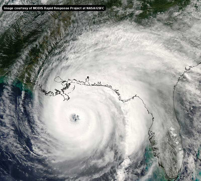
Also -- just saw the first daylight visual sat image of this, and WOW. There are no words. Incredible.
Edited by Margie (Sun Aug 28 2005 08:50 AM)
|
pcola
Storm Tracker

Reged: Wed
Posts: 344
Loc: pensacola/gulf breeze
|
|
Thanks for the update Ron..I never have had much faith in the model but the UKMET has done well this year...I think I am going to take a few extra precautions over what I have already done... I hope the UKMET is wrong but "right hooks" scare me on storms to my west
--------------------
Erin 95 , Opal 95, Ivan 04, Dennis 05, and that's enough!!!!
|
GuppieGrouper
Weather Master
Reged: Fri
Posts: 596
Loc: Polk County, Florida
|
|
Under the circumstances, I would think that the models would be redundant and misleading. The people who are directly in front of the hurricane for 200 miles inland need to be doing preparations such as gasoline and food supplies. I remember well how the experts did not think that the Central Florida area would be all that affected by and it is still devastated. The flooding rains, episodic tornados and the surprise that land mass did not disrupt Charly like they thought it would. The models are now very misleading and people are grasping at straws for reassurance that they will not be harmed. All in all, model watching is very interesting from 300 or 400 miles away. It will be interesting when the mayhem is over to find out which models performed consistently well in predicting direction and intensity.
--------------------
God commands. Laymen guess. Scientists record.
|
Psyber
Storm Tracker

Reged: Fri
Posts: 231
Loc: Ontario, Canada
|
|
Personally I don't see anything in her way to slow her down other than perhaps direct a bit more back towards NE from it's current W-N/W tract. Water is plenty hot there on its way.
God...908! How low is she going to to go???
|
Ron Basso
Storm Tracker

Reged: Thu
Posts: 267
Loc: hernando beach, FL
|
|
I found an interesting article on the web concerning Hurricane Camille. For those in the path of this storm, a must read.
http://www.geocities.com/hurricanene/hurricanecamille.htm
--------------------
RJB
|
lunkerhunter
Storm Tracker

Reged: Fri
Posts: 248
Loc: Saint Augustine, FL
|
|
Margie,
The NHC Special Discussion shows Cat 5, 155mph at landfall 30.0N 89.8W.
|
Margie
Senior Storm Chaser

Reged: Fri
Posts: 1191
Loc: Twin Cities
|
|
Quote:
Margie,
The NHC Special Discussion shows Cat 5, 155mph at landfall 30.0N 89.8W.
I know that, because it's been the same for three days.
The discussion also says,
"NO CHANGES TO THE TRACK OR WIND RADII FORECASTS HAVE BEEN MADE."
--------------------
Katrina's Surge: http://www.wunderground.com/hurricane/Katrinas_surge_contents.asp
|
hurricane expert
Really Not an Expert
Reged: Thu
Posts: 105
Loc: florida
|
|
90L invest is looking pretty good we are also going to keep a eye on it for the week.
|
Hugh
Senior Storm Chaser
Reged: Fri
Posts: 1060
Loc: Okaloosa County, Florida
|
|
Quote:
Margie,
The NHC Special Discussion shows Cat 5, 155mph at landfall 30.0N 89.8W.
155mph is *technically* a Cat 4. 156 is the min for Cat 5. Having said that, Dr. Lyons just indicated it may shift NNE before landfall, shifting the severe damage away from N.O. That's not me guessing - that's an "expert" opinion!
My opinion of Dr. Lyons isn't great - I miss John Hope - but that's what he gets paid for.
--------------------
Hugh
Eloise (1975) - Elena and several other near misses (1985) - Erin & Opal (1995) - Ivan (2004)
|
Ron Basso
Storm Tracker

Reged: Thu
Posts: 267
Loc: hernando beach, FL
|
|
Quote:
Thanks for the update Ron..I never have had much faith in the model but the UKMET has done well this year...I think I am going to take a few extra precautions over what I have already done... I hope the UKMET is wrong but "right hooks" scare me on storms to my west
P'Cola, I'd prepare for the worst due to the massive size of this storm. You're probably in the Hurricane Force wind field and with surges projected 6-7 feet (perhaps 10 feet near the AL-FL line), this is no storm to fool around with - from earlier posts, I think you're pretty close to the beach and GOM, correct? Among other things, I'm worried about a massive storm surge with KAT. Look, caused 8 ft of surge in St Marks, and it was a much smaller and weaker storm. You will no doubt be on the strongest, deadliest east side - I know you're fascinated like the rest of us with this freak of nature, but get to higher ground if you're in the tidal flood zone.
--------------------
RJB
|
SirCane
Storm Tracker

Reged: Tue
Posts: 249
Loc: Pensacola, FL
|
|
Dr. Lyons on said that could push NE before landfall. That would be good for NO but bad for those in MS/AL/FL. UKMET hints that may happen. 
--------------------
Direct Hits:
Hurricane Erin (1995) 100 mph
Hurricane Opal (1995) 115 mph
Hurricane Ivan (2004) 130 mph
Hurricane Dennis (2005) 120 mph
http://www.hardcoreweather.com
|
Margie
Senior Storm Chaser

Reged: Fri
Posts: 1191
Loc: Twin Cities
|
|
Can start to see the leading edge of on NO long-range radar now.
--------------------
Katrina's Surge: http://www.wunderground.com/hurricane/Katrinas_surge_contents.asp
|
Random Chaos
Weather Analyst

Reged: Sat
Posts: 1024
Loc: Maryland
|
|
Quote:
Dr. Lyons on said that could push NE before landfall. That would be good for NO but bad for those in MS/AL/FL. UKMET hints that may happen. 
He's doing the right thing even if it isn't going to shift east. Why? Becuase everyone anywhere near should be scared and should be leaving. By purposely saying the storm may shift east, he is making more people realize they could be in the intended path. This is good considering the unpredictability of hurricanes.
-------
An impressive IR and Visible signature this morning. Wow!
|
Terra
Storm Tracker
Reged: Tue
Posts: 286
Loc: Kingwood, Texas
|
|
I just wanted everyone to know that my son and I are safe and sound in Shreveport. We stopped at a hotel to use their internet, and I don't know what kind of access I will have with the family I am staying with. I'll try to keep in touch. I just looked at this storm and heard the updates on the drive. I tried to encourage everyone I could to get out, but I wonder if there will be enough time. I had no traffic, but I left at 1:30 AM. I;m guessing most people will leave in the next few hours and the traffic will be horrible. This is going to be bad news whereever it goes....
-- Glad to hear you are safe and sound Terra! Stay safe!
Edited by RedingtonBeachGuy (Sun Aug 28 2005 09:07 AM)
|
Hugh
Senior Storm Chaser
Reged: Fri
Posts: 1060
Loc: Okaloosa County, Florida
|
|
Two computer models (UKMET and another that I can't determine the name of) now put significantly east of N.O. - one at Biloxi and one at the AL/FL border. Combine that with Dr. Lyons' comments, and it may be time for Mobile/Pensacola residents to run too.
Update: I just overlayed the MSLP over the Visible loop on SSD's website. is following - right now - between two isobars, but is inching toward the right isobar. Interesting to look at.
--------------------
Hugh
Eloise (1975) - Elena and several other near misses (1985) - Erin & Opal (1995) - Ivan (2004)
Edited by Hugh (Sun Aug 28 2005 09:06 AM)
|
pcola
Storm Tracker

Reged: Wed
Posts: 344
Loc: pensacola/gulf breeze
|
|
Thanks Ron..though I am on the Gulf Breze Peninsule..I am on the highest ground here..if you call 27ft high....I think I will put the tracks and models away, and just follow the visible and IR images...but I wanted to hear Dr Lyons reasoning for the NNE turn near landfall, and would that be landfall at the mouth of the Mississippi or farther north..I have see 2 storms hit the Boothville area of LA but by going noth they re-emerge over water in the Mississippi sound for several more hours... I wish he had made that a little clearer
--------------------
Erin 95 , Opal 95, Ivan 04, Dennis 05, and that's enough!!!!
|
twizted sizter
Weather Guru
Reged: Tue
Posts: 184
|
|
Still no madatory evacs in NO or Biloxi according to ..Superdome for special needs/nowhere to go cases...going to be devestating wherever she goes but especially if NO...good to see people deciding on their own to go though...as someone who foolishly stayed for Andrew I can honestly say leaving is the best thing to do.
|


 Threaded


 [Re:
[Re: 


