CFHC

Reged: Sun
Posts: 148
Loc: East Central Florida
|
|
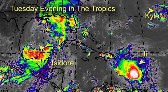
The energy... and core... sapped from Isidore... Will it be a hurricane once more?
Possibly. It has to regain an awful lot of momentum and showers around the core, and the main convection is away from it. The time over the Yucatan really killed the system.
Still TX/LA to AL/FL borders for landfall there, but I'm not expecting more than a cat 1 at the moment, although it could change... watch the system.
Lili is going to fight land a few times, and we may see it go in the Gulf or along the east coast. Apologies today, I've been away most of the time and have yet to go through all the data as of yet.
I hope for more tomorrow. Sorry for the short update today.
Cancun, Mexico Radar
NRL Monterey Marine Meteorology Division Forecast Track of Active Systems (Good Forecast Track Graphic and Satellite Photos)
NASA GHCC Interactive Satellite images at:
North Atlantic Visible (Daytime Only), Infrared, Water Vapor
Some forecast models:
NGM, AVN, MRF, ETA ECMWF
DoD Weather Models (NOGAPS, AVN, MRF)
AVN, , , , , UKMET
Multi-model plots from WREL
Other commentary at Mike Anderson's East Coast Tropical Weather Center, Robert Lightbown/Crown Weather Tropical Update Accuweather's Joe Bastardi, Hurricane City Weather Audio Broadcast Network - Live Audio from Jim Williams and Barometer Bob , mpittweather , Tropical Weather Watchers.Com (JasonM) Gary Gray's Millennium Weather, Barometer Bob's Hurricane Hollow, Snonut, Ed Dunham and Jason M in our Storm Forum Even more on the links page.
- [mac]
|
Anonymous
Unregistered
|
|
Will Izzy ever get its act together? He still has about 36 or 48 hours to organize itself. I dont know but i would like some other folks opinion please. I think the winds may get back upt o about 80 but maybe not anymore then that.
|
Rick
Weather Watcher
Reged: Wed
Posts: 28
Loc: Wisconsin
|
|
Yup! That's what I said!
Now back to the irrelevance of the models...
Here's an exerpt from their homepage about "its flexibility"
"This infrastructure includes software to handle parallelization, input and output, data exchange between various model grids..."
I think their "parallelization" software is either spazzing, or is seriously flawed.
Those crazy ivy-leaguers probly drafted the met dept to be on their football teams! Don't be surprised if we start seeing X's and O's on the model output!
|
Bruce
Weather Guru
Reged: Fri
Posts: 139
Loc: Palm Bay, Florida
|
|
I agree, Cat 1 at best, if that.
|
Anonymous
Unregistered
|
|
izzy will be like all the rest this year nothing but rain something this year wont let them do a lot up this way lions said he is as strong as he will get uper low wont let him grow up i say m/al line sun storm izzy just another dud
|
Anonymous
Unregistered
|
|
I want to know why this new thread still says a TX/LA landfall is still possible. There is no way it can come back to the west to do that.
|
Anonymous
Unregistered
|
|
no cat izzy making me dizzy must be a dog
|
Anonymous
Unregistered
|
|
Hopefully Izzy dont do an Opal on us 60mph now 12 hours later cat 3 heading for mobile
|
Londovir
Weather Guru
Reged: Fri
Posts: 112
Loc: Lakeland, FL
|
|
I know all the models and such say Lili is heading towards Haiti/DR, but looking at the GOES IR loop for the western Atlantic, it looks so much like the convection of the storm is heading northwards towards Puerto Rico, the eastern side. Weather observations from the US Virgin Islands and N.A. are showing heavy gusty winds, almost at T.S. strength. Lili is pulling clouds into it from the south as well.
Or...I've stared at these loops of Izzy until he was giving me a tumor. 
Jay
--------------------
Londovir
|
Steve
Senior Storm Chaser

Reged: Wed
Posts: 1063
Loc: Metairie, LA
|
|
Yeah, isn't it though. That's the same thing I was saying. He's definitely one for the history books. I haven't looked at too much footage of Cuba and Mexico, but from the little I did see, some communities got hammered. There had/has to be some 40"+ spots and that just doesn't happen too often in the real world. It goes to show how strong and how much energy Isidore had, and really, how formidable it could have been for some of us. As it is now, they're up to Advisory #35 (winds now gusting 25-30 the last few minutes). So if he regenerates - as has been speculated all along - I think it's a storm name worth retiring.
Here are some of my reasons:
1) Confounded (mostly) models and forecasters.
2) Long tracked, SeptemberAfrican Wave system.
3) Various damage and disasters in many countries (Jamaica, Cuba, Mexico, etc.).
4) Reached strong Cat 3 status (had much higher potential).
5) Outer influence affected the entire I-10 Corridor east of Lake Charles 2-3 days before landfall.
6) 35 advisories - (possibly 45 by landfall or shortly thereafter).
It's also been a lot of fun to track for the last couple of weeks on the internet.
--------------------
MF'n Super Bowl Champions
|
ShawnS
Storm Tracker
Reged: Fri
Posts: 226
Loc: Pearland,Tx
|
|
What's the deal with the mention of TX/LA landfall still? No way this thing can come back west! I guess just covering the old backside there...hahaha!
|
tom5r
Weather Watcher
Reged: Mon
Posts: 49
Loc: Islamorada, Florida
|
|
Lili's definetly pulling clouds in from the south and is also starting to wrap around the west side and moving more to the northwest.
http://www.srh.noaa.gov/radar/loop/DS.p20-r/si.tjua.shtml
|
Rick
Weather Watcher
Reged: Wed
Posts: 28
Loc: Wisconsin
|
|
"It's also been a lot of fun to track for the last couple of weeks on the internet."
I don't think I've seen one single complete acurate track or intensity forecast from anyone (including myself). This one definitely stymied everyone. But seeing how those better educated and more in the loop got it wrong too, I don't feel so bad! 
crow on the house! Avila's buying! 
|
HanKFranK
User

Reged: Mon
Posts: 1841
Loc: Graniteville, SC
|
|
think lili may have opened up, or had the center reform east again. theres no deep convection within about 100 miles of where the 8pm position was given. recon is down there now, we'll know pretty soon.
isidore is of course doing little if anything. some of the convection from the southern band group is closing on the se side of the center.. or at least suggesting it wants to. izzy really did an amazing job at wrecking itself over land.
im still getting flashbacks to fore caster matthew. maybe it's the unintelligible posts i keep seeing. then there are the allcaps ones, THE VOICE OF GOD. maybe the same person? well, they do have one thing in common.. neither ever has a clue. anybody else notice this?
HF 0128z25september
|
Anonymous
Unregistered
|
|
Londovir, Lili is still getting hammered by shear from the ULL to its SW and I've also had trouble figuring why the fix on the center was put where it was. Look at the latest IR loops and you will see the convection getting pulled in towards the center which is on the SW side of the convection. She is there and yes your eyes aren't deceiving you, the convection is getting torn northward. This will settle out towards morning and tomorrow we will see a more organized system. Latest has her going into the Yucatan at 120 (like they need it). Don't agree with that. Think it will go over Cuba and run up the Fl east or west coast. GOM possible, but I think it will run out of ridge. Izzy will still get cranked. Trust me. T'storms now coming in from the NE closer towards the center. I still say Cat 2, maybe 110 mph. Cheers!! Steve H.
|
Alan
Unregistered
|
|
This question was on the last board, so I thought I would repost and hopefully get an answer.
The same trough that is supposed to turn Isidore due north for the next two days is supposed to be so far south as to turn Lili shortly thereafter.
If this trough is going to be moving through and past Florida before Saturday, why wouldn't the trough push Isidore even further east?
I mean, is Isidore going to bust through the trough as it moves past her?
|
Bruce
Weather Guru
Reged: Fri
Posts: 139
Loc: Palm Bay, Florida
|
|
If that is the center on the PR Long range loop it must be much farther north than 13.5N. And seems to be moving NW. I dont think the Radar would be picking up the center if it was at 13.5.
|
Rick
Weather Watcher
Reged: Wed
Posts: 28
Loc: Wisconsin
|
|
I think we killed the GHCC site! 
Either us... or CNN...FOX... and MSNBC 
|
FlaRebel
Unregistered
|
|
I still stick to my original landfall of Biloxi to Apalachicola. I think Apal. is out of the question, but Pensacola is not. The track will have to be shifted east in the next 12 hours. Just my humble, novice opinion.
|
Rick
Weather Watcher
Reged: Wed
Posts: 28
Loc: Wisconsin
|
|
"If that is the center on the PR Long range loop it must be much farther north than 13.5N. And seems to be moving NW. I dont think the Radar would be picking up the center if it was at 13.5."
More like 16.5, I'd say!
|


 Threaded


