CFHC

Reged: Sun
Posts: 148
Loc: East Central Florida
|
|
What an amazing track Isidore was.... first getting a run in with South America it pulled north a bit to enter the Western Caribbean. Was it planned to be a problem for Jamaica or Cuba at the time? No, but it flooded Jamaica and grazed the western part of Cuba. Now it was to move west... right?
Projections had it to go west then loop in the gulf and head north, rightly so many along the Gulf coast started to watch Isidore like a hawk. A few models hinted at a southerly jog first, but not into the Yucatan. Category 3 almost a 4, oops Isidore slides south into the hurricane warning area causing much pain to the North Yucatan coastline in Mexico. This rather impressive storm collapsed over the Yucatan, but it was so big the energy was disbursed, after it eventually moved back over the water it was unable to do anything more than hold its own... almost in a way that parts of the system were non tropical and others were.... Causing rain even to Florida it dumped copious amounts of rain along the coast and caused a minor storm surge in the New Orleans area...
To those who think Isidore was a bust, be glad, the alternative of a category 3 or 4 hitting New Orleans is not pretty. Much like Hurricane Bret a few years ago hitting in an unpopulated area in Texas, this one managed to avert a real catastrophe. Our intent here is not to want storms like this to hit, but to provide information to help determine what is going on. The interest level is higher amongst people when a major is in the Gulf, the numbers prove it, for reason... It could affect many people. The entire time I wanted it to fall apart and was looking for ways for it to happen. The Yucatan landfall wasn't it for me. Mexico sure did not need it. The rather light hit on New Orleans may be a slight wakeup call for them, though, and if that's the case then that would be the good side to it.
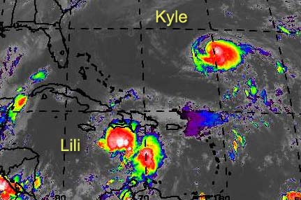
Lili will follow fairly closely Isidore's previous path near Jamaica and Cuba, and after that I'm not able to say yet, but of course again we must all watch it. There are Tropical Storm watches up now for Jamaica.
Kyle is backing down fairly far south and believe it or not we still may have to watch this one along the Eastern Seaboard. Models differ some one to loop it around and back northeast, others like the AVN pull it southeast even more.
NRL Monterey Marine Meteorology Division Forecast Track of Active Systems (Good Forecast Track Graphic and Satellite Photos)
NASA GHCC Interactive Satellite images at:
North Atlantic Visible (Daytime Only), Infrared, Water Vapor
Some forecast models:
NGM, AVN, MRF, ETA ECMWF
DoD Weather Models (NOGAPS, AVN, MRF)
AVN, , , , , UKMET
Multi-model plots from WREL
Other commentary at Mike Anderson's East Coast Tropical Weather Center, Robert Lightbown/Crown Weather Tropical Update Accuweather's Joe Bastardi, Hurricane City Weather Audio Broadcast Network - Live Audio from Jim Williams and Barometer Bob , mpittweather , Tropical Weather Watchers.Com (JasonM) Gary Gray's Millennium Weather, Barometer Bob's Hurricane Hollow, Snonut, Ed Dunham and Jason M in our Storm Forum Even more on the links page.
- [mac]
|
WXMAN RICHIE
Weather Master

Reged: Mon
Posts: 463
Loc: Boynton Beach, FL
|
|
The tropics are coming back today. Lili has reformed and Kyle is down to 27 N. Lili will start to follow Izzy's track toward Jamaica and Cuba, but surely won't do a loop over the Yucatan after that. Kyle keeps losing latitude which makes it more and more likely it may bother the east coast later on. Izzy's worst outcome is that it causes sooo much rain in Louisville that the Seminoles lose. 
--------------------
Another typical August:
Hurricane activity is increasing and the Red Sox are choking.
Live weather from my backyard:
http://www.wunderground.com/weatherstation/WXDailyHistory.asp?ID=KFLBOYNT4
|
Rasvar
Weather Master

Reged: Fri
Posts: 571
Loc: Tallahassee, Fl
|
|
o/~Lili, Lili, Lili, get your adverbs here o/~ opps, wait that was lolly. Either way, I suspects lots of adverbs and adjectives will be used over the next week as Lili acts like Izzy's twin. Probably quite a few four letter words. Another system with a lot of destructive potential in the future.
--------------------
Jim
|
FlaRebel
Unregistered
|
|
Bastardi seems to thing we will have another major hurricane in the gulf in a few days. All I can say is....oh boy. 
|
Anonymous
Unregistered
|
|
00Z globals have all changed their tune. I had her pegged as an eastern Gulf storm on Tues. or Wed. but it may well be a Central/Western Gulf storm. It appears that a blocking high will be in place when Lili is at 85W with another building in from the W (models are predicting trof between the two to be fairly weak). I like my seasonal Mississippi idea, but I think Lili is 150 miles east or west of Isidore's landfall in Lafourche Parish. This means a) A landfall in SW LA or N TX or b) a hit from Pascagoula to Panama City. Seasonally, this should be another LA/MS boder storm because that's where all of them have come in.
I'm going with a Waveland/Henderson Point, MS landfall and effects from Houma (pron. HO-ma) to Destin. In this scenario, beach erosion should continue along the FL and AL shores - not something you guys are anxiously awaiting.
Steve
|
Anon Frank p
Unregistered
|
|
For the record...
NWS stated today in the paper that Izzy had an 8 foot tidal surge...they had predicted only about 4-6 feet prior to the arrival of the storm...
I estimated in my post at the high of the storm at least 8 feet and maybe 9... at my house it was closer to 9 feet...
This gives Izzy a STRONG Cat 2 storm surge for the MS coast
Cat 1 - 4-5 ft
Cat 2 - 6-8 ft
Cat 3 - 9-12 ft
Cat 4 - 13-17 ft
Cat 5 - 18+
Lessons learned.... a large wind field associated even with a system less than hurricane force winds can generate larger than expected tidal surges...
Frank P
(Mike for some reason I was unable to log on)
|
Rasvar
Weather Master
Reged: Fri
Posts: 571
Loc: Tallahassee, Fl
|
|
I won't make any predictions. I won't trust any model. Only thing I have to say is that the is saying Texas, therfore: look out Eastern Gulf!
--------------------
Jim
|
Mike
Weather Watcher
Reged: Fri
Posts: 40
Loc: Port St. John, Fla
|
|
Here is the Vortex message for Lili, at least they could send one this time....
000
URNT12 KNHC 271215
VORTEX DATA MESSAGE
A. 27/1215Z
B. 16 DEG 06 MIN N
74 DEG 33 MIN W
C. NA
D. 40 KT
E. 017 DEG 38 NM
F. 090 DEG 041 KT
G. 024 DEG 44 NM
H. EXTRAP 1003 MB
I. 24 C/ 316 M
J. 26 C/ 312 M
K. 24 C/ NA
L. NA
M. NA
N. 12345/01
O. .1 /2 NM
P. AF985 0913A LILI OB 12
MAX FL WIND 41 KT NE QUAD 1134Z. SLP EXTRAP FROM 1500FT.
With estiminated surface winds at 40K, I am curious when they will upgrade it. Max flight level winds were only 41K.
Edited by Mike (Fri Sep 27 2002 10:12 AM)
|
Bill
Unregistered
|
|
As of 11am---what I wonder is on the recon it said CP is 1003...advisory says 1005...fluctuations already? Note, located further east, not good for Fl and Gulf....
IHS,
Bill
|
Rasvar
Weather Master
Reged: Fri
Posts: 571
Loc: Tallahassee, Fl
|
|
While everyone watches Lili, I have a feeling in my gut that when everything is said and done, Kyle might be knocking at the backdoor and trying to sneak into Florida by the end of next week.
--------------------
Jim
|
MikeC
Admin
Reged: Sun
Posts: 4543
Loc: Orlando, FL
|
|
Just a note about the flhurricane downtime today. Flhurricane was down from 11AM to 2:30 PM after a hardware misconfiguration. Thanks to Brian Lawson up in Virginia for helping me fix the problem, and we're back up and running.
|
Hurric
Weather Guru

Reged: Thu
Posts: 116
Loc: Port St. Lucie, Fl
|
|
CNN reporting up to 800 missing and dead in ferry boat capsizing in a "Fierce Storm" off the coast of Senagal.
Here is a link to the wave that emerged from the African coast and probably caused this tragedy
http://www.ssd.noaa.gov/PS/TROP/DATA/RT/eatl-ir4-loop.html
|
Mike
Weather Watcher
Reged: Fri
Posts: 40
Loc: Port St. John, Fla
|
|
Great work guys. I was starting to have FLHURRICANE.COM withdrawls 
|
Kevin
Weather Master

Reged: Fri
Posts: 524
Loc: EC Florida
|
|
I'll start this post by saying this: with the current pattern in place, I am fairly confident that Kyle, Lili, or both storms could make landfall in the US. If we only have one landfall, one will mimic what the other does. Or, we could have seperate influences on the systems and they both come towards a US locations.
Kyle: Still holding his own. Quite a tenacious storm, but I can see some dry air starting to push on the north side of the storm. He should be weakened for the next 48 hours but intensify after that. The storm should meander W and SW through 72 hours. After that, the steering patterns will be more defined, one way or the other.
Lili: She's looking just as good as she did previously and the pressures are actually falling. The center relocation (easterly) along with the NW movement may not be good for the eastern GOM in the long-term.
Best bet at this point is that the storms play "copycat". No definite forecast at this point.
Kevin
|
JT1016
Unregistered
|
|
Only 13 comments when there are 2 storms with definite US landfall possibilities. What has happened to this board. I think Lili has an even better chance than Izzyto mpact the US with major force. I do believe she will enter the Gulf, but I thuink she will go a little further east this time. After reading Joe B this morning, i believe that even though she will probably cross a lareger portion of Cuba than Izzy, she will not be a strong whenshe does so. Therefor, she should be in better shape to regenerate after exiting the coast. I will not make a prediction as of yet, but will amke the same old statment........ Everyone along the Gulf coast should closely monitor the progress of what will become Major Hurricane(Weak cat 3) Lili.
|
Skeeter
Registered User
Reged: Thu
Posts: 2
Loc: Florida, Kissimmee
|
|
I think everybody is a little worn out after last week. It will be interesting to see how Lil does in the next 24-36 hrs. I am thinking east central Cuba, skirts EC Florida and Landfall around AppyLachyCola. There......On record for now, gotta go back to work........everyone have a great weekend.
Skeeter
|
tom5r
Weather Watcher
Reged: Mon
Posts: 49
Loc: Islamorada, Florida
|
|
Looks like Lili is getting her act together. Poor Jamaica. Seems they're gonna get another soaking.
|
LoisCane
Veteran Storm Chaser

Reged: Fri
Posts: 1236
Loc: South Florida
|
|
Id think that the lower keys will get a soaking from Lili, thinking that more and more
--------------------
http://hurricaneharbor.blogspot.com/
|
tom5r
Weather Watcher
Reged: Mon
Posts: 49
Loc: Islamorada, Florida
|
|
yes loiscane, I've been thinking the same thing but, thats what I thought with Izzy too. We'll just have to wait and see.
|
Southern
Unregistered
|
|
Oh dear, I dont think I can handle another storm. Hannah and Izzy was enough. I do think if another storm comes toward Mobile, we will have lots of destruction, trees falling due to sogging ground, etc.
I pray Lili dies....... 
|


 Threaded


