CFHC

Reged: Sun
Posts: 148
Loc: East Central Florida
|
|
The last part of todays 11AM National Hurricane Center Discussion on Lili states "BOTTOM LINE IS THAT WE SHOULD HAVE A MAJOR HURRICANE NEARING THE GULF COASTLINE IN THREE DAYS TIME". This says it all.
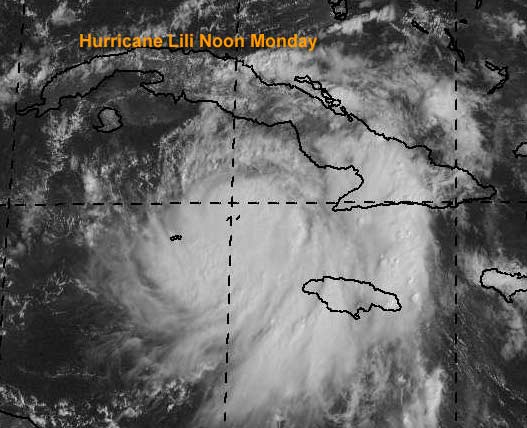
Apologies for the lack of updates, I was taking a break because Lili will be the story this week. Lili is forecast to be a major Hurricane in the Gulf of Mexico mid week, nearing either the Northern Texas or Louisiana coastline. This one won't have the Yucatan to pulll it apart like Isidore, so everyone along the Gulf coast, and especially the areas I mentioned needs to watch the storm like a hawk.
Now to dehype. The storm is just barely a hurricane, and is about to clip Jamaica, the Caymans, and Western Cuba again. Causing even more rain and a bit of wind for them, when they do not need it. Later on in the week the has it nearing Lousiana and North Texas. I don't see any reason right now to disagree, but anything is possible. Ignore the hype and watch the facts and do as the local authorities say. Once lili is in the Gulf, it will not be a meanderer like Isidore was, so the time is shorter. The water is very warm in the gulf and can support a major hurricane, and that is what the hurricane center is predicting also. Be aware of this fact, and be ready to take action if the need arises.
Kyle is still around as well, now threatening Bermuda again, but moving away from the US.
Havana, Cuba Radar
NRL Monterey Marine Meteorology Division Forecast Track of Active Systems (Good Forecast Track Graphic and Satellite Photos)
NASA GHCC Interactive Satellite images at:
North Atlantic Visible (Daytime Only), Infrared, Water Vapor
Some forecast models:
NGM, AVN, MRF, ETA ECMWF
DoD Weather Models (NOGAPS, AVN, MRF)
AVN, , , , , UKMET
Multi-model plots from WREL
Other commentary at Mike Anderson's East Coast Tropical Weather Center, Robert Lightbown/Crown Weather Tropical Update Accuweather's Joe Bastardi, Hurricane City Weather Audio Broadcast Network - Live Audio from Jim Williams and Barometer Bob , mpittweather , Tropical Weather Watchers.Com (JasonM) Gary Gray's Millennium Weather, Barometer Bob's Hurricane Hollow, Snonut, Ed Dunham and Jason M in our Storm Forum Even more on the links page.
- [mike@flhurricane.com]
|
Rich B
British Meteorologist
Reged: Sat
Posts: 498
Loc: Gloucestershire, England, UK
|
|
Well the islands of Cayman Brac and Little Cayman are probably taking a lashing right now. The centre of Lili is very near these islands, so they will be experiencing winds of very near Hurricane force. Unfortunately i can find no webcam links to these islands so i cant say what it looks like. However, the webcam from Grand Cayman showed sun shine earlier, and it all seemed very calm there.
Cuba looks set to take a battering again tonight or early tuesday, with Lili expected to strengthen and follow much the same route as Isidore did when it crossed Cuba.
Too early to say where lil will go after Cuba, but my bet woould be a Louisianna landfall around Friday...
Kyle is threatening Bermuda too, with a Tropical Storm Watch for that island too.
Rich B
StormWarn2000
--------------------
Rich B
SkyWarn UK
|
Brett
Unregistered
|
|
People in the northern GC really have to watch her. With her current forward speed, and the potential for it to increase slightly, regardless of whether she moves over Cuba or not, she is going to be full throttle in the SE GOM. Thinking back to Isidore, I recall how it seemed to pick up intensity just prior to landfall...think of what would have happened if Isidore had gotten its act together in the southern GOM... This is exactly what we could have on our hands with Lili. I am putting Lili just west of New Orleans, at strong Cat 3, with a large storm surge from fast forward speed. I see this one as more of a wind event, unless she slows or becomes more expansive as Isidore did.
I still don't know what to do with Kyle. Looks to me on visible that hes moving SW again...and I am not sure I buy the 's center. Looks to me like is much further south. But then again, I am always wrong as far as Florida predictions go....so perhaps indeed this one will get kicked out east.
|
Colleen A.
Moderator

Reged: Sat
Posts: 1432
Loc: Florida
|
|
I just spent a good 1/2 hour looking at the Strike Probabilities between 9/27 and 9/30
Key West now has the highest strike probabilities @18% at 11:00AM which is up from 14% at 5:00AM today.
Buras, LA was at it's highest, 18% on 9/30 at 5:00AM, and has now dropped to 13% as of the 11AM advisory.
Texas strike probablities range as high as 12% at 11AM today (Galveston) and as low as 4% in Brownsville, TX today at 11AM.
I don't know if this means the storm track has been shifted to the right; giving Key West the highest percentage or what.
If you have any thoughts on this, please let me know.
--------------------
You know you're a hurricane freak when you wake up in the morning and hit "REFRESH" on CFHC instead of the Snooze Button.
|
Steve H.
Unregistered
|
|
No Brett, you're right. I've been watching Kyle thins morning and he's been coming SW as he is re-organizing and now it's a different ballgame as he will come under the influence (drinkin' agin) of the building east coast ridge. Could threaten Bahamas/Florida during the next few days. Bastardi mentioned it on his 11am update. Lili will bash somebody. A strong Cat 3 is quite likely, maybe Cat 4, the water CAN support it! The conditions are quite favorable as well. Be ready to take quick action with her, she's a mover. Will not be like Izzy. This will hit hard and fast; God Bless! Cheers!! Steve H.
|
MikeB
Unregistered
|
|
Does anyone else see what JoeB is talking about on Kyle? I looked at Storm Floater 2 visible loop and it does look like a LLC forming around 27.5 and 67.0 moving slowly sw. I am total novice so I'm not sure. Good luck to people in the northern GOM.
|
Frank P
Veteran Storm Chaser
Reged: Mon
Posts: 1299
|
|
Colleen, I've been watching them too... MS coast went down a little at 11:00 am as opposed to 5:00 am while the Tx coast when up a notch... Prior to that MS keeping inching up... first time we have gone down.... Models of late keep moving it just a shade to the left...
I just can't see this thing staying on a wnw track the entire time its in the GOM, not in October... but you never know... somewhere its going to turn NW, this will be critical... its all about the timing... this will be the storm of the season, and for somebody maybe the decade... that remains to be seen... I can find no model that has this thing east of New Orleans... if one is out there I'd like to see it.. I posted last night it would be west of NO... and not Texas... still feel that... center will go inland somewhere in LA... but you never know... This could shape up as Shawns big time storm... wonder where he is.... HEY SHAWN WAKE UP.... THERE'S A STORM A BREWING AND HEADING YOU WAY....
|
Steve
Senior Storm Chaser

Reged: Wed
Posts: 1063
Loc: Metairie, LA
|
|
I think that is a function of the fact that she's likely to pass nearer to Key West than any other American Point in the next day or so. Look at the A, B, C, D columns. Key West is 9% during "A" and 8% "B" (8am Tues to 8pm Tues) and 1% C. They added them all up and came up with 18%. New Iberia at 13% is the current highest probability in "D" (8am Wed to 8am Thurs). New Iberia is my landfall call within 60 miles. The reason I think Buras went down is that it's now evident to the TPC that Lili is going to pass south of her - possibly by as much as 125 miles. In no way IMHO is the threat to FL increasing with time - certainly not the peninsula. You guys should get off without even any feeder bands except possibly extreme SW FL might get clipped with a brief squall.
And you should know this: The main threat to Florida this year is from Paloma! Paloma is coming, and he/she's coming to get us all!
Steve
--------------------
MF'n Super Bowl Champions
|
ShawnS
Storm Tracker
Reged: Fri
Posts: 226
Loc: Pearland,Tx
|
|
I'm not saying anything about this one.
|
Houstontracker
Unregistered
|
|
I'm starting to get a little nervous about this one. Just my luck, we are playing the Gators this week and my electricity will probably be off so I won't get to watch it or listen to it. Probably a blessing huh.
|
jth
Storm Tracker
Reged: Mon
Posts: 275
|
|
New Iberia looks good as a western point. I think New Orleans as the eastern point. THis one seems pretty cut and dry. Lets just hope she doesn't expand in size. I don't think the Alabama coast can take another beating.
|
Frank P
Veteran Storm Chaser
Reged: Mon
Posts: 1299
|
|
Hey HT... you guys over there need to watch this one for sure... not sure what would be worse for you right now Lili or the Gators, probably Gators... hehe
Shawn, get your supplies ready dude ....
|
scottsvb
Weather Master
Reged: Mon
Posts: 1184
Loc: fl
|
|
go to sports bar... anyways Kyle is indeed moving SSW. Location is now near 27.5N and 67.2W. Location by the early this morning was bases on Qicksat pass near12z. The center is a very tight gradiant with not much inflow to the E of the system. Currently Kyle is still inline to pick up the westerlys but barely as they will come down to near 25N over the next 24 hours. If Kyle can feel more of the ridge to its W and get to near25N and 70W by late tonight then he could make it under the ridge. Some models do show a brief S jog before the E turn. This E turn isnt forcasted anyways till late tonight or early Tuesday morning. Timing is very important.Right now Kyle is stuck between a building strong ridge off the NE coast of Florida and a weaker ridge to his ESE. The florida ridge will build more S over the state and the bahamas as the westerlys move down and east of the high near Kyle. Basically next 12-18hours will determine if Kyle can make it under or near 25N and 70W.
Lilly is getting better organized and should maintain a WNW movement over the next few days and turn N late in the 5 day period by the time she gets to near 92W. Generally all the models are in agreement and we see nothing in the WV to let us know nothing will stop her progress WNW till she gets to this point. Westerlys by Friday over the southern Great planes will begin to affect Lilly and cause some sheer and turn the system N then NE just after landfall. Currently landfall is forcasted to be just east of the TX/LA border by near 100 miles or less. BTW colleen percentages go up when a system gets closer to a city in miles from that point to the center of a system, but it doesnt mean its going to hit that location, for example you live near tampa and your percentages might go up slightly until later tuesday night then they should be nonexistant. scottsvb hurricaneupdatecenter
|
MikeC
Admin
Reged: Sun
Posts: 4543
Loc: Orlando, FL
|
|
Just a note of a few system changes I've made.
Anonymous posters are now required to type in a username to post, previously it would default to "Anonymous" and was getting a bit difficult to track who was who, so now, at least, they have to type something in. Registration is still the better way.
Patched up the advisory system on the front page so that the occurance of incomplete advisory posts should happen a LOT less frequently. Especially under high load situations. Ie, when the front page would not load all the way. This isn't my final fix for it, but I did manage to make it happen much less than before.
Thanks,
|
HanKFranK
User

Reged: Mon
Posts: 1841
Loc: Graniteville, SC
|
|
ill be checking my intensity against fixes over the next 60hr.. by the time lili is making landfall i should be on the road back home... but until then, betting i wont be off by more than 8mb/15mph. give or take 50miles on the landfall point, if i have to make any corrections i'd expect to nudge it east.. but doubt i'll be going past say atchafalaya bay.
kyle just did the center reform stunt... now it's a complex system that, as scott alluded to.. could possibly get under the westerlies. funny how the center reform has made the anticyclonic loop prediction come true.. in a mishmosh fashion. sunk the eightball, but wrong pocket. anyhow im not expecting kyle to move much for the next 24hrs.. and even if it does go east, it might not get taken out, just dragged some and then dropped.
94L.. spitting out low level swirls. exactly what is going on under the remaining convection is unsure but probably nothing.. we are probably watching this invest in its death throes. interestingly, ive got an inkling that an wave may be forming near 9N54W. take a look on visible closeups and youll see what i'm getting at. yeah, probably nothing, but if it isnt.. you know.
have a good day, and smile shawn, the bullseye is close to you this time. dont think youll get a direct hit, but could be in on some of the action.
HF 1836z30september
|
Steve
Senior Storm Chaser
Reged: Wed
Posts: 1063
Loc: Metairie, LA
|
|
12z (Canadian Model) has inched Lili a bit further east - near Central LA Coast (my call). 6z inched her a little further west (TX/LA Border, Sabine River). 12Z isn't up yet on the PSU site, but Kyle is. Wonder why they're holding it back?
Steve
--------------------
MF'n Super Bowl Champions
|
Brett
Unregistered
|
|
I just don't buy it. One series of model runs last night, which happen to agree on the east motion, and the forecast is completely changed. Now, as the acknowledges, the center reforms more than 200 miles to the south, and "the track will have to be adjusted." I'm sorry, but these are professionals, correct? I mean, I know its far from an exact science, but isn't there some thinking going on here, other than model-reliance? I don't know. Lately, I have been feeling that they are doing nothing more than regurgitating models, which change as the data that is put into them changes. I would love to see some creative, intuitive, human forecasting from the .
I don't mean to bash. I just don't think its such a sure thing that this system will get picked up by a trof that, admittedly, "appears weak" on imagery. My prediction? Not necessarily that it becomes a U.S. landfall event, but I think its gonna keep heading SW into the Bahamas, perhaps move a little bit east, get left behind...and we have a hurricane just east of the Bahamas, with an inclination to nudge west...
As for Lili? Watch out west of New Orleans. Yikes.
Thoughts?
|
Stevenotloggedin
Unregistered
|
|
12z is a bit east from 6 runs and back to the Central LA coast. UKMET 12Z is heading toward Golden Triangle still but a bit weaker than the 00Z run.
Steve
|
dennis
Unregistered
|
|
From the hpc discussion:
LATEST SATL IMAGERY IS SUGGESTING A NEW CIRCULATION CNTR MAY BE
FORMING TO THE SW OF KYLE ALONG 66-67W. THIS CNTR HAS THE POTENTIAL TO
MOVE IN A GENERAL WLY DIRECTION ON THE SRN SIDE OF THE UPR HIGH
EXPECTED IN THE MEAN TO BE OFF THE SERN COAST. CONFIDENCE ON THIS
FEATURE IS VERY LOW...GIVEN POOR DEPICTION IN THE MODELS. ATTM...AFTER
COORDINATION WITH THE TPC...A WWD TRACK TO INVOF 25N 77W ON SAT (DAY
5) IS DEPICTING ON THE HPC SFC PROGS. THIS LOW MAY CONT WWD INTO THE FL
PENINSULA BY SUN (DAY 6) BEFORE BEGINNING TO PUSH BACK TO THE
NORTHEAST AHEAD OF A FRONT MOVG INTO THE SERN QUARTER OF THE NATION
BY NEXT MON (DAY 7).
|
Brad in Miami
Unregistered
|
|
What is the "hpc discussion" and where can I find it? Doesn't seem to be from the discussion.
Thanks.
-Brad
|


 Threaded


