CFHC

Reged: Sun
Posts: 148
Loc: East Central Florida
|
|
11:00PM EDT Update:
Turning more to the NNW now. Storm is still 145, pressure is up a bit. Update tomorrow am.
8:00PM EDT Update:
8PM advisory confirms it has leveled off. Forward motion has it moving slightly faster. It appears slightly elongated so the northward curve will start soon. Central Louisana is the best bet for landfall at this time.
Others east and west of this area should be ready also.
More to come...
7:30PM EDT Update:
Lili still strong, but I think has leveled off. Landfall still looks to be western or Central Louisiana.
5PM EDT Update:
Evacations all across the warning areas.
Lili now at 140MPH winds.
Our site is feeling the load right now, along with network problems at the host. Sorry for the slowness.
3PM EDT Update:
Lili
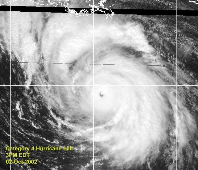
Moving Northwest toward western Louisiana.
I hope your preperations are done and you are out of the evacuated areas. If not, quit looking at this screen and do what you must.
Apologies for the slowness. It is network troubles at our hosting site, it is being worked on.
2PM EDT Update:
Hurricane Lili now a category 4 system, with winds of 135MPH and a pressure of 941 millibars. Warnings remain the same. This type of storm is capable of a 10-15 foot storm surge.
11am EDT Update:
From the hurricane center:
STOP THE PRESSES...THE LATEST FIX FROM THE HURRICANE HUNTER... RECEIVED JUST AFTER THE REST OF THE ADVISORY PACKAGE WAS TRANSMITTED...INDICATES THE PRESSURE HAS DROPPED TO 948 MB. SHOULD THIS BURST OF INTENSIFICATION CONTINUE...THE INITIAL AND
FORECAST INTENSITIES WILL LIKELY HAVE TO BE REVISED UPWARD ON THE NEXT PACKAGE.
Lili now a CAT 3 Hurricane with 120mph winds (and probably stronger with the hurrcane center's last minute comment) / 948 mb moving NW at 15
Original Post
The space shuttle is grounded today (launch was scheduled for today) over fears that the storm may interrupt mission control operations in the Johnson Space Center in Houston, for one good reason.
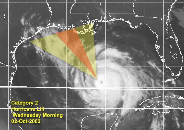
Hurricane Lili is a strong category 2 storm this morning. Some voluntary evacuations have been issued along the Louisiana coastline, and I'd recommend anyone in the hurricane watch/warning area prepare for the storm. I believe it will strengthen later today into a 3, and possibly close in on a high 3 low 4 before making landfall midday tomorrow.
Today is the day to prepare folks, and to make decisions. Go by how your area is and by what local authorities and news media pass along. The string of 3 years without a hurricane landfall in the US is about to end with a major making landfall.
Updates to the news will be coming as the situation warrants. Posts letting everyone know what's going on in the affected areas are welcome, but please make sure you are safe.
Beaumont TX TV: KFDM
New orleans TV: 6 4
Baton Rouge: wbrz 2
Kyle has restrengthened once again, and amazingly is still up in the air as to what it may eventually do. "We're still on ya Kyle, don't try to sneak in on us."
NRL Monterey Marine Meteorology Division Forecast Track of Active Systems (Good Forecast Track Graphic and Satellite Photos)
NASA GHCC Interactive Satellite images at:
North Atlantic Visible (Daytime Only), Infrared, Water Vapor
Some forecast models:
NGM, AVN, MRF, ETA ECMWF
DoD Weather Models (NOGAPS, AVN, MRF)
AVN, , , , , UKMET
Multi-model plots from WREL
Other commentary at Mike Anderson's East Coast Tropical Weather Center, Robert Lightbown/Crown Weather Tropical Update Accuweather's Joe Bastardi, Hurricane City Weather Audio Broadcast Network - Live Audio from Jim Williams and Barometer Bob , mpittweather , Tropical Weather Watchers.Com (JasonM) Gary Gray's Millennium Weather, Barometer Bob's Hurricane Hollow, Snonut, Ed Dunham and Jason M in our Storm Forum Even more on the links page.
- [mike@flhurricane.com]
Edited by MikeC (Wed Oct 02 2002 10:46 PM)
|
jth
Storm Tracker
Reged: Mon
Posts: 275
|
|
It may just be me, but has Lili turned NW lately and even a little bit north of NW? I know it shouldn't be happening yet, but it sure looks like it to me. Oddly enough, it even looks like she is slowing a little. Probably just a temporary delay though. New Iberia beware.
|
FlaRebel
Unregistered
|
|
Looks like only .1 of a degree North to me since 8 AM advisory, but I'm a newbie!
|
Southern4sure
Weather Guru

Reged: Sun
Posts: 121
Loc: Land O Lakes, FL
|
|
oh dear, I hope this isnt a change in direction. I wil stay on this board all day!
Southern
|
HanKFranK
User

Reged: Mon
Posts: 1841
Loc: Graniteville, SC
|
|
kyle has a banding type eye-spot on visible. just still no steering currents.
anyhow, lili leveled off the morning, not the rapid deepening rate seen overnight. if lili stops right here, louisiana gets the storm has been putting on the official (winds with a 954mb hurricane usually in cat 3 range). however, i can envision lili having another rapid deepening phase later today. will see.
94L much less organized than i was thinking. some of the convection has peeled back, revealing that there isnt much more than a weak low at the southern end of the convective mass. waiting on marco then, i guess.
HF 1347z02october
|
Sonic
Unregistered
|
|
Latest Fix shows Max Flight Level Winds found to 125 KTS.
Doesn't that correspond to about 105-110 knot surface winds? Gotta be a cat 3 next advisory you think.
|
dav
Unregistered
|
|
kyle getting much better organized.
|
jth
Storm Tracker
Reged: Mon
Posts: 275
|
|
I think that corresponds to 110 -115 k winds at the surface. Though this would suggest 130MPH winds, the next advisory will probably only increase to 115-120.
|
BabyCat at work
Unregistered
|
|
I can't believe New Orleans is still asleep...
The least they could do is say something...
|
Brad in Miami
Unregistered
|
|
I guess everyone will see this at the end of the 11 am discussion:
STOP THE PRESSES...THE LATEST FIX FROM THE HURRICANE HUNTER...
RECEIVED JUST AFTER THE REST OF THE ADVISORY PACKAGE WAS
TRANSMITTED...INDICATES THE PRESSURE HAS DROPPED TO 948 MB. SHOULD
THIS BURST OF INTENSIFICATION CONTINUE...THE INITIAL AND
FORECAST INTENSITIES WILL LIKELY HAVE TO BE REVISED UPWARD ON THE
NEXT PACKAGE.
|
Toni
Unregistered
|
|
To all of those that will feel the wrath of LILI I just want to let you know that My thoughts and prayers are with you.
Toni
|
Brett
Unregistered
|
|
Honestly, tho we all are very interested in these storms, with their beautiful satellite signatures, and the raw power of nature, and we would all like to experience a hurricane at least once (a minimal one), the latest images of Lili are downright frightening. If you are anywhere on the coast in Louisiana, batten down, or get out. This is a very serious situation, and my thoughts go out to all of you up there. Be SMART about this.
|
Steve
Senior Storm Chaser

Reged: Wed
Posts: 1063
Loc: Metairie, LA
|
|
Hank Frank did a good job with his intensity forecast, and he claims not to be a guru! HA! LOL. Things are getting interesting. I hope the storm moves in down in the marshes. Cameron Parish (and whatever one is right east of it) 'way down there' are major rice farming areas. There aren't a lot of people there except country folk and farmers. Whomever suggested that it's a big recreational area down there is right. I've only been down to the coast on that side twice. You take Hwy. 27 south from Sulphur (just west of Lake Charles). There are a few towns (Hackberry, Cameron) with maybe a thousand or so people, but there is an abundance of wildlife and waterfowl down there. Otherwise, there are a lot of rice farms. The only population centers of note are (1,000-200,000) are Sulphur, Lake Charles, Lafayette, New Iberia, Franklin, Crowley, Abbeville and a couple other villages and towns. I like rice as much as the next guy, but if it's rice farms that need to pay, so be it. They're flooded terraces anyway!
Steve
--------------------
MF'n Super Bowl Champions
|
Frank P
Veteran Storm Chaser
Reged: Mon
Posts: 1299
|
|
What an impressive system, esp on IR... amazing... this thing has the real chance of being a Cat 4 prior to landfall.... Lili still seems to be tracking off to the NW somewhere between 300 and 310 degrees... typical wobbles as expected in the track... Your heart goes out to anyone who falls in its eventual path... right now the SW coast of LA looks to be targeted.... S Central LA will also take a serious pounding.... she is due south of Biloxi right now, and moving off to the NW certainly gets us out of any danger from her... whew.. thank goodness.... this very well might end up being someone's storm of the century....
|
HanKFranK
User
Reged: Mon
Posts: 1841
Loc: Graniteville, SC
|
|
ah, wouldnt go so far as that. the century is still quite young, indeed. btw steve my intensity forecast has been consistently too low. should be 105mph, 963mb right now if i was verifying.. 15mb and mph too low. incedentally i had it at the current numbers.. 120mph/948mb.. at 11pm eastern tonight. dont think the dry air entrainment will cause much of a problem, there isnt a heck of a lot of subsidence.. and what is there is mostly off to the left of the path. my beaumont/sabine pass landfall point is going to be too far west. looks like it's going in near the cameron/vermillion parish line. jennings, crowley, abbeville look to take the hardest hits.. core of the strongest winds should come inland between lake charles and lafayette. may be hurricane force winds as far inland as alexandria. the landfall zone isnt a heavily populated area, so total storm damage shouldnt be as high as if the storm went in right over port arthur or new iberia.
kyle.. where is that westerly push under the ridge? storm hasnt moved much in the last three days.. thought deepening would fix that. the official still takes it sw eventually.. will see.
HF 1540z02october
|
Houstontracker
Unregistered
|
|
are evacuating all their aircraft from Ellington field right now. I know that this is a precaution to protect their multi-million dollar aircraft inventory but how much is a life worth?
Obviously the TPC is very confident of their track, but the margin of error is small. An 8 or 10 hour delay in a northward turn puts a major metroplitan are in danger with little time left to prepare. We are rapidly approaching the point of no return for an evacuation of Galveston Island.
I hope for the TPC's sake and ours in SE Texas that they are correct.
I
|
Steve
Senior Storm Chaser
Reged: Wed
Posts: 1063
Loc: Metairie, LA
|
|
6th storm of the year to bring rain to my house. That's a record for me.
Steve
--------------------
MF'n Super Bowl Champions
|
Bruce
Weather Guru
Reged: Fri
Posts: 139
Loc: Palm Bay, Florida
|
|
Steve, how far away are you from where lili should make landfall?
|
Steve
Senior Storm Chaser
Reged: Wed
Posts: 1063
Loc: Metairie, LA
|
|
especially 'as the crow flies.' The interstate runs NW before it turns west again. Using the I-10 from memory, It's 80 miles to Baton Rouge, then 47 to Lafayette. New Iberia is probably 35 miles south of Lafayette or so. Lake Charles is 72 miles west of Lafayette. So using those figures, Lake Charles would be about 200 miles west of me no the I-10 and maybe 170 (?) on a straight line. Metairie is suburban New Orleans. We're immediately (and abutt) the city to its west. If you look at a map and don't know where New Orleans is, look at "LA" and you'll see Lake Pontchartrain in the SE corner of the state. The city borders the lake to the South. The western periphery of the lake is about 20 miles WNW from where I live.
Hope that kindasorta makes sense.
Steve
--------------------
MF'n Super Bowl Champions
|
OrlandoDude2
Unregistered
|
|
Good Luck to those of you in LA.. I hope everyone is prepared for the aftermath.. Man, it brings back bad memories from Andrew. The hurricane is intense, but living with the aftermath for months afterwards sucks.. Just be prepared and no hurricane parties.. You will need 100% of your senses.
|


 Threaded


