MikeC
Admin
Reged: Sun
Posts: 4543
Loc: Orlando, FL
|
|
9:15 AM EDT 11 September Update
92L hit a wall of dry air that we missed, 90L won't get organized. And 91L still may develop over the next few days.
It is the historical peak of season so it's still worth watching.
8:20 AM EDT 10 September Update
92L (The system northeast of the Caribbean) fell apart last night as it just failed to persist convection, and it lacked a lot of low level activity and convergence.
Oddly enough there is convection, but well to the southwest of where the "center" was. It's safe to consider 92L a non issue, thankfullty, unless this new pulse of convection keeps going.
91L looks like it still may form within the next day or two, and 90L is just holding on. Gabrielle is moving away from the Mid Atlantic states, but has weakened to a depression.
Original Update
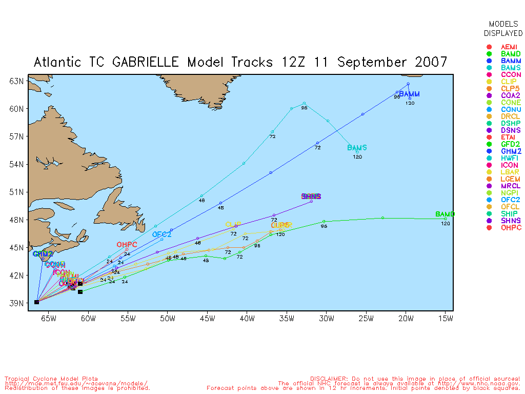
Tropical Storm Gabrielle made landfall at 11:45 on Cape Lookout in North Carolina. Much of the rainfall remains offshore as the storm is expected to head out to the northeast and away from the mainland.


September 10th is the statistical peak of hurricane season, and the activity out there now would seem to verify that:
90L is a system in the southern Gulf, conditions and shear are not favorable at all for this system, and development really isn't expected as it moves westward.
90L Forecast Lounge Here) .
90L Development chances within next 48 hours
Code:
(forget it) 0 1 2 3 4 5 6 7 8 9 10 (sure thing)

            [----*---------------]
91L in the Central Atlantic is moving westward and conditions may improve there in the next few days and we'll watch for development. Currently this probably has the best chance of all the "invests" for development.
91L Forecast Lounge (Discuss Here)
91L Development chances within next 48 hours
Code:
(forget it) 0 1 2 3 4 5 6 7 8 9 10 (sure thing)

            [----------*---------]
Most interesting to us in Florida is 92L, which is northeast of the Caribbean. It is in a somewhat favorable area and may form into a depression within a day or so.
92L is near 17.3N 57.5W, and so far, it has become much better organized in the past 24 hours.
The current movement is to the west at 13 MPH. This system will be moving away from a zone of westerly shear into an area of almost no wind shear, so the prospect of development is high. A west northwest track is anticipated. Additional development is possible and residents of the Bahamas and the southeastern U.S. should closely monitor the development of this potentially troublesome system. The only saving grace that may deflect this is the front currently over the middle section of the US. More to come on this system later.

Forecast Lounge for 92L here
92L Development chances within next 48 hours
Code:
(forget it) 0 1 2 3 4 5 6 7 8 9 10 (sure thing)

            [-------*------------]
More can be found on Ed Dunham's blog post below "Wave Mongering Part II"
We're recording Mark Sudduth's (Hurricane Track.com) webcam tower on Hatteras along with the Morehead city radar for Gabrielle.
You can see these At this link.
Radar Loops
Morehead City, NC Radar Loop
(Latest Static)
Wimington, NC Radar Loop
(Latest Static)
StormCarib Reports from the Caribbean Islands
Caribbean Weather Observations
Barbados Brohav Weather Fax
Full Caribbean Radar Composite
Caribbean Broadcast Corporation (TV/Radio from Antilles)
San Juan, PR NWS Page
Various Caribbean Radio Stations
DR1 Dominican Republic Hurricanes
Gabrielle Event Related Links


SFWMD Model Plot (Animated Model Plot) SFWMD Hurricane Page
[https://flhurricane.com/floatanimator.php?year=2007&storm=7 Flhurricane Satellite Floater Animation of Gabrielle
GOES Floater
Animated Model Plot of Gabrielle
Clark Evans Track Model Plot of Gabrielle
(Animated!) Model Plots in Google Earth - In Google Maps
Clark Evans Intensity Model Plot of Gabrielle (Animated!)
Clark Evans Track Plot of Gabrielle
Other Model Charts from Clark
Clark Evans Top 10 Analog Storms for Gabrielle
More model runs on from RAL/Jonathan Vigh's page
NRL Info on Gabrielle -- RAMMB Info
COD Atlantic Satellite View
90L (Gulf System) Event Related Links


SFWMD Model Plot (Animated Model Plot) SFWMD Hurricane Page
[https://flhurricane.com/floatanimator.php?year=2007&storm=8 Flhurricane Satellite Floater Animation of 90L
GOES Floater
Animated Model Plot of 90L
Clark Evans Track Model Plot of 90L
(Animated!) Model Plots in Google Earth - In Google Maps
Clark Evans Intensity Model Plot of 90L (Animated!)
Clark Evans Track Plot of 90L
Other Model Charts from Clark
Clark Evans Top 10 Analog Storms for 90L
More model runs on from RAL/Jonathan Vigh's page
NRL Info on 90L -- RAMMB Info
COD Atlantic Satellite View
91L (Central Atlantic) Event Related Links


SFWMD Model Plot (Animated Model Plot) SFWMD Hurricane Page
[https://flhurricane.com/floatanimator.php?year=2007&storm=9 Flhurricane Satellite Floater Animation of 91L
GOES Floater
Animated Model Plot of 91L
Clark Evans Track Model Plot of 91L
(Animated!) Model Plots in Google Earth - In Google Maps
Clark Evans Intensity Model Plot of 91L (Animated!)
Clark Evans Track Plot of 91L
Other Model Charts from Clark
Clark Evans Top 10 Analog Storms for 91L
More model runs on from RAL/Jonathan Vigh's page
NRL Info on 91L -- RAMMB Info
COD Atlantic Satellite View
|
Storm Hunter
Veteran Storm Chaser

Reged: Wed
Posts: 1370
Loc: Panama City Beach, Fl.
|
|
Well, its going to be a busy week!!! Looking at vis on Gabrielle... its about to make second landfall on the mainland of NC... it crossed the sounds and should come ashore again near swanquater, and head up towards Elizabeth City, then out to the NE into the atlantic. Shear seems to have gotten the system, late yesterday evening, the mid-upp level, could never get back over the center of the low level. No covection never was able to wrapp around the center... 92L is looking a little better this afternoon.
**1:45pm cdt... Cleary, based on sat and level II radar data... Gabrielle has made the second landfall along NC.. mainland.... Vis floater *** i don't think will make an adv., but will mention it in the 5pm adv pkg.
--------------------
www.Stormhunter7.com ***see my flight into Hurricane Ike ***
Wx Data: KFLPANAM23 / CW8771
2012== 23/10/9/5 sys/strms/hurr/majh
Edited by Storm Hunter (Sun Sep 09 2007 02:52 PM)
|
HanKFranK
User

Reged: Mon
Posts: 1841
Loc: Graniteville, SC
|
|
gabrielle has thundered ashore as a monstrous 50-mph tropical storm, crossing the sound and peninsula areas west of the outer banks. for some reason it left all of its convection at morehead city. there isn't much that can be said for it... thanks to an upper low diving off and sitting on it for most of the week, the storm never got well organized and developed very slowly. i maybe earned a cookie with a side of crow on that one.
it's september 9th, so naturally the season is trying to put on it's peak-time show. like most are saying, 91L has the best chances to develop in the long term, due to location and organization. it should do so slowly, probably not becoming a named system until it gets a bit past 40w. the islands need to watch it for late week, as it may be a maturing system by then.
of more immediate concern, but less certainty are the gulf invest 90L and 92L northeast of the leeward islands. 90L gets a good grade for persistence, but a bad one on execution. the upper winds over the gulf aren't helping, but even a weak system could cause a lot of trouble in texas due to it having something akin to a summer monsoon season. it's chances are weak, but it won't have to do much.
92L has some unpleasant early guidance taking it to the east coast of florida, and that sort of track would likely verify with ridging to the north strengthening. it isn't overtly developing as of yet, but has shown a good lengthy convective burst and some tendency to develop outflow aloft--the synoptic pattern will favor it if it starts to develop, so it's worthy of concern, if not immediately threatening.
odd first-half count on the season. five tropcial storms and two category five hurricanes. beam me up, mr scott.
HF 2110z09september
|
TampaBayHurricaneChaser
Registered User
Reged: Fri
Posts: 2
|
|
The following post is Not an Expert Opinion,
but it presents a superficial analysis of some of the
synoptics.
After hours of extensive research into the synoptics, I think
I have a better idea what may happen:
1. With the ridge building, we will see a WNW
motion towards the Bahamas.
2. 2 troughs are forecasting to dig into
the Southeast by Friday, the first on Tuesday.
In 2-3 days, 92L will feel the influence
of these troughs, and depending on the
strength of the ridge, may recurve
while close to florida's east coast and head
up to the carolinas.
3. Some moisture the next 2-3 days over florida,
but after that, with 90L moving west, and
92L making a close call with the coast, the weather
will be dry or wet depending on where
92L decides to recurve.
4. If the ridge wins out, I see a track
into Southeast florida. If the trough wins out,
I see impacts on North Carolina.
5. It appears that many have provided
evidence of a strengthening ridge, in that case
the threat to florida's southeast coast
may increase, unless a trough pushes
92L away.
6. The environment is looking very favorable
over the bahamas, so some rapid intensification is
likely, once a depression gets going.
7. The current decline in convection is due to diurnal
minimum. It WILL refire. The same thing happened
last night. Therefore 92L is not dead.
After reading HankFrank's post, I will lean towards
the ridge solution for now.
|
HanKFranK
User
Reged: Mon
Posts: 1841
Loc: Graniteville, SC
|
|
heh... 92L kinda quit tonight. worries can stay at whisper volume for now, unless it starts acting up again. it has a really long way to go, if it even decides to go that way.
91L looks like a storm in 2-3 days. 90L is persistent, too. we'll have action this week regardless of whether 92L is the cause.
HF 0112z10september
|
typhoon_tip
Meteorologist
Reged: Wed
Posts: 576
|
|
Quote:
92L has some unpleasant early guidance taking it to the east coast of florida, and that sort of track would likely verify with ridging to the north strengthening. it isn't overtly developing as of yet, but has shown a good lengthy convective burst and some tendency to develop outflow aloft--the synoptic pattern will favor it if it starts to develop, so it's worthy of concern, if not immediately threatening.
odd first-half count on the season. five tropcial storms and two category five hurricanes. beam me up, mr scott.
HF 2110z09september
I am a bit mystified at 92L this evening... Amazing deterioration has taken place since 3pm; yet despite the now complete absence of convection (there is 0!) there remains a fairly tight vortex signature by satellite alone. This may be a mid-level circulation, however, one that did not get a chance to come down to the surface because the convection spontaneously and rather inexplicably evaporated.
There may be some dry air contamination but the water vapor imagery shows that the column colocated with 92L is actually moist; so it is not really clear whether this is even ingesting outside the moist domain of the interior.
SAL is not a factor at this time, either.
The streamline analysis at 850mb level suggests some modest convergence, while the streamline analysis at 200mb level shows a strong divergence:
850: http://www.nhc.noaa.gov/tafb/QUNA00.jpg
200: http://www.nhc.noaa.gov/tafb/QHQA17.jpg
...These two factors should be generally favorable when in tandem. (convergence/divergence couplet in the 850mb and 200mb levels respectively is an initially favorable atmospheric circulation pattern for TC genesis)
Oceanic heat content is sufficiently present.
Not sure why this thing suddenly stopped convection
|
typhoon_tip
Meteorologist
Reged: Wed
Posts: 576
|
|
Quote:
Since no one will say it...
DYNO GEL !!! :-)
Just a few tons should of done it. 92L looked like it was gonna go, and then....
TBC
Just in the last frame, however, some suggestion of new convection is forming west of the preceived center. May not amount to much, but then again...got to start somewhere.
http://www.ssd.noaa.gov/goes/flt/t4/loop-avn.html
Edited by typhoon_tip (Sun Sep 09 2007 10:30 PM)
|
punkyg
Weather Watcher

Reged: Sun
Posts: 44
Loc: sanford, florida
|
|
(Chat Room post deleted.)
Edited by Ed Dunham (Tue Sep 11 2007 07:43 AM)
|
cieldumort
Moderator

Reged: Mon
Posts: 2305
Loc: Austin, Tx
|
|
Yeah, I think 92L has the makings of what -could- *rapidly* reorganize into a player, for the reasons mentioned above (erm, less the dyno-gel.. I think that idea has been shown to be "prehistoric" these days. Sticky subject, anyway).
Much like Tip above, I was just about mystified by the rapid seeming evaporation of convection, but 92L does seem to be at the apex of an active area which rolled off Africa a few days ago, and somewhat suspect that it is competing with several of these TC seedlings embedded within this subtle gyre for the right stuff. Perhaps some easterly shear got involved at just the wrong time, as well. (All guesses).
Looking at the entire stretch of the Tropical & Subtropical Atlantic it is really hard to argue against at least one or two more named systems forming this week. I've also been eyeballing the large deeply-layered non-tropical low way north for another extra to sub to tropical transition. This time of year it's entirely possible to see that happen. Several more impressive waves are also set to roll off Africa.
Gabrielle didn't look a whole lot better than 96L of a few days ago, really. Highly sheared and lots of dry air, but when it comes down to it, it seems likely that will probably log Gabby's peak intensity before landfall at 65MPH in the historical record based on a recon finding of 55 knots in the SE quad Sunday morning, and plenty of ground-truthing from area ships, buoys, etc. to support that. Up to a foot of rain has already fallen under that convective burst just offshore. Too bad more of it couldn't come ashore and help quench the region's thirst. Lopsided tropical cyclone, but noteworthy. 96 probably peaked at around 45 knots. Maybe gets a post-season bump. At least a good second look, I would bet.
La Nina appears to be baked in the cake. As has been mentioned elsewhere, these can tend to draw out the length of an Atlantic season. Given that we are about to cross the mid-point with at least seven names, to extrapolate that out to 14 by November 30 is really easy to do, especially considering how the east Pac appears to be in the process of shutting down a bit in the face of cooler SSTs and general subsidence.
If you had told me at the start of 2007 that we would be about to turn the clock on September 10 with five storms, but also 2 cat 5s, I would have asked what you were smokin'. Weeiird.
|
drohner
Unregistered
|
|
I do not know if the following exists: It is the peak of hurricane season and we have a very nice curve. This to me is not a very good indicator of what on average the United States can expect during a season. A more interesting figure to me by day of year is % of Hurricanes that actually hit the United States and the number on average that hit the US by day of the year. To me this says something about the guiding conditions that either favor or disfavor hurricanes toward the US as time progresses.
|
allan
Weather Master

Reged: Thu
Posts: 468
Loc: Palm Coast, Florida
|
|
I see peoples point on bashing 92L due to the lack of convection but, it does appear on the last few IR images, the convection (blob) to the south is sort of slowly rejoining the little swirl to its north. The reason why it hasn't developed is because in that part of the Atlntic is a downward motion on the pulse.. once it gets more west, it should enter the upward motion and should get going. A track to Florida sounds reasonable at this point.. most models don't recongize this but may I remind you that most of teh models never recongized Felix when it was an invest.. so far in my opinion, the models are doing horrible this year with the exception of Dean. We'll have to see if this rejoining force continues with 92L, it may be entering the upward motion.
http://www.ssd.noaa.gov/goes/east/carb/loop-rb.html
--------------------
Allan Reed - 18,9,5
|
ltpat228
Storm Tracker

Reged: Tue
Posts: 201
Loc: Port Saint Lucie FL
|
|
http://www.nrlmry.navy.mil/tc_pages/tc_home.html
|
Beach
Weather Guru

Reged: Wed
Posts: 187
Loc: Cocoa Beach/Banana River
|
|
http://www.ssd.noaa.gov/goes/east/carb/loop-ir2.html
The disturbance isn't done yet.
Take a close look at 15-20N / 60-65W
The "dough" is still rising and will soon be able to go into the oven.

Edited by Beach (Mon Sep 10 2007 01:45 PM)
|
danielw
Moderator

Reged: Wed
Posts: 3525
Loc: Hattiesburg,MS (31.3N 89.3W)
|
|
92L- the system NE of the Leeward Islands yesterday fizzled out.
However... the mid level IR vortice signature is still present and the main convection is now over the Northern Leeward Islands.
The latest satellite imagery is showing high thin cirrus over the Northern Leeward Islands. Indicating No appreciable wind shear at this time. The outflow 'fingers' also would indicate high pressure over or near to the system leading to a more favorable area for possible intensification.
Whether this system is named, numbered or the like. It is still important to keep a frequent check on it.
That said, watch both the convective area and the Mid Level Vortice. As they appear to have split and these often will spin down to the surface at a later time... and closer to the SE U.S.
Reference TD10 of 2005. Split and part of the TD10 signature became . While this scenario is not likely. Prior systems have been dropped from and MY sites only to be reposted later.
90L GOM
Present satellite imagery indicate a possible Near-to-Surface Low forming in the Middle/ Western Gulf of Mexico. (see attachment)
Centered near 25N/ 91W.
System appears to be elongated from the NE to the SW.
Current surface analysis would indicate a postion closer to 25N/ 92W.
http://coolwx.com/buoydata/regions/gulfplot.php
Lowest surface pressures are in the Western GOM and present wind speeds are under 18 knots with max gusts at 23 knots.
91L Area east of the Lesser Antilles.
As of 10AM EDT Monday. has posted a possible NOAA Research mission into this wave on the 13th at 00Z or 8PM EDT on the 12th.
Edited by danielw (Mon Sep 10 2007 01:32 PM)
|
Ed in Va
Weather Master
Reged: Fri
Posts: 489
Loc:
|
|
From Henry Margusity's block at AccWeather...does he know what he's talking about? He was hyping Gabby big time, so his recent tropical predictions have been off mark:
We are heading toward a change in the overall weather pattern, one that might even put a damper on the tropical season for the U.S. The mean trough position as per the will end up in the Eastern part of the country which means a series of cold front will head southeast. Parts of the northern Plains into the Great Lakes and Northeast could be facing the first frosts the next two weeks as the cool air masses come on down. It also means that any tropical systems will be blocked by the strong jet from heading to the East and Southeast. I guess one could say that leaves the door open for Texas for any tropical systems, but then again, it would have to be a Gulf of Mexico development on the tail end of ending front for that to occur.
--------------------
Survived Carol and Edna '54 in Maine. Guess this kind of dates me!
|
tumbleman
Unregistered
|
|
http://www.ssd.noaa.gov/goes/east/watl/loop-rgb.html
Seems like a definite twist at 16N, 62W.
Thoughts? Is this 92 reborn?
|
scottsvb
Weather Master
Reged: Mon
Posts: 1184
Loc: fl
|
|
TX will have no chance of tropical development as systems that break off from fronts generally will head N and NE.
|
Ed in Va
Weather Master
Reged: Fri
Posts: 489
Loc:
|
|
For what it's worth, the 's most recent run picks up a storm to be NE of PR by this weekend:
http://moe.met.fsu.edu/cgi-bin/gfdltc2.c...;hour=Animation
--------------------
Survived Carol and Edna '54 in Maine. Guess this kind of dates me!
|
LoisCane
Veteran Storm Chaser

Reged: Fri
Posts: 1236
Loc: South Florida
|
|
yeah i saw.. and bends it back later
but it moves very slow... is that possible to move that slow?
just have to wait and see.. right now everything out there is being pulled or sheared a bit to the north
that big upper level low in the north atlantic is creating not the best environment for the peak of the season weak out there
http://weather.unisys.com/satellite/sat_wv_east_loop-12.html
--------------------
http://hurricaneharbor.blogspot.com/
|
weatherguy08
Weather Hobbyist
Reged: Thu
Posts: 60
Loc: Miami, Fla.
|
|
Interesting remarks in the AFD from NOAA Lake Charles, LA:
"THERE IS SOME DEFINITE CYCLONIC TURNING IN THE LOW LEVELS ABOUT
350 MILES SOUTH OF CAMERON. CURRENTLY...THE UPPER LEVEL WINDS
OVER THE NORTHWEST GULF...WHICH IS THE GENERAL DIRECTION THE WAVE
IS HEADED...ARE UNFAVORABLE FOR TROPICAL DEVELOPMENT. THE AND
NAM ARE FORECASTING THIS TO CHANGE OVER THE COURSE OF THE NEXT 24
TO 36 HRS...AND GIVEN THE WAVES SLOW WESTWARD PROGRESS...IT IS NOT
OUT OF THE REALM OF POSSIBILITY THAT FURTHER DEVELOPMENT COULD
TAKE PLACE...THOUGH IT WOULD BE A SLOW PROCESS."
I check this product several times daily, including the past few days, and this is the first mention of the system in the GOM.
|


 Threaded


