MikeC
Admin
Reged: Sun
Posts: 4543
Loc: Orlando, FL
|
|
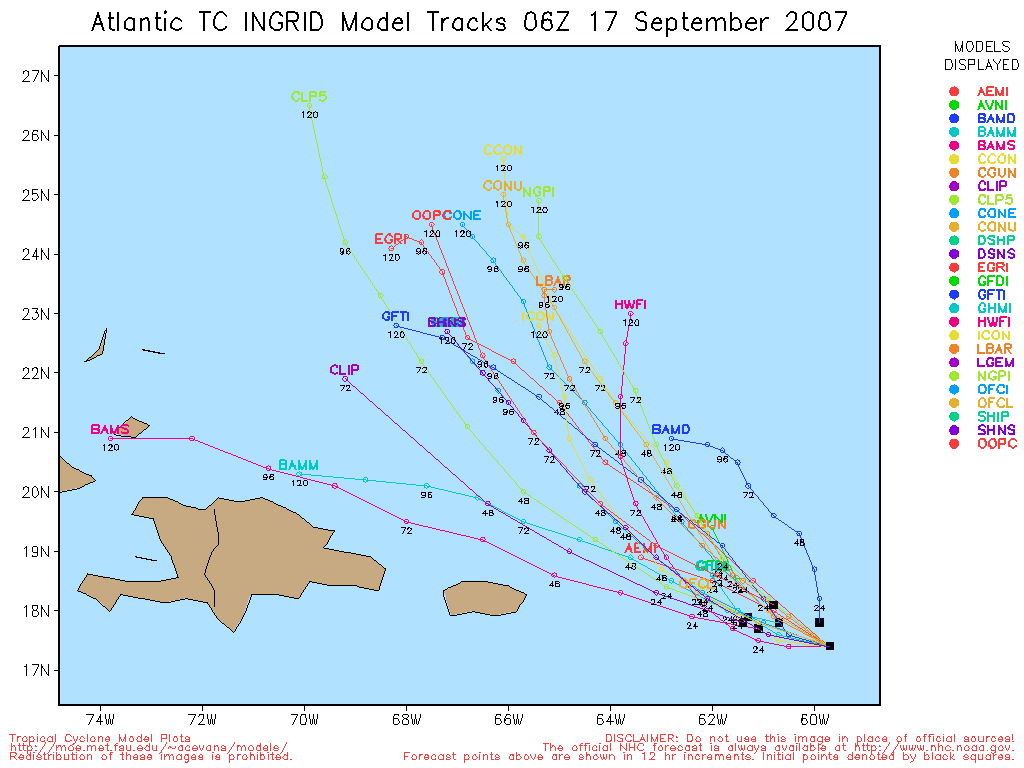
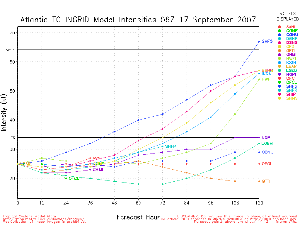
11:15 PM EDT 13 September Update
A NOAA recon plane on a research mission in TD 8 this evening found 35kt surface winds associated with the cyclone, supporting an upgrade to Tropical Storm Ingrid. Ingrid is expected to weaken back into a tropical depression under strong vertical wind shear over the next few days. Meanwhile, the remnants of Humberto, which made landfall early this morning near High Island, TX, are bringing 5-10" rainfall totals to parts of Texas, Louisiana, and Mississippi. Its remnants are expected to move slowly south and eastward over the next day or two, potentially back over the Gulf of Mexico into the weekend. No redevelopment is expected.
1:30 AM EDT 13 September Update
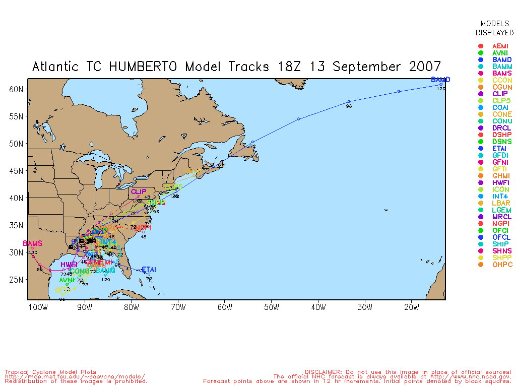
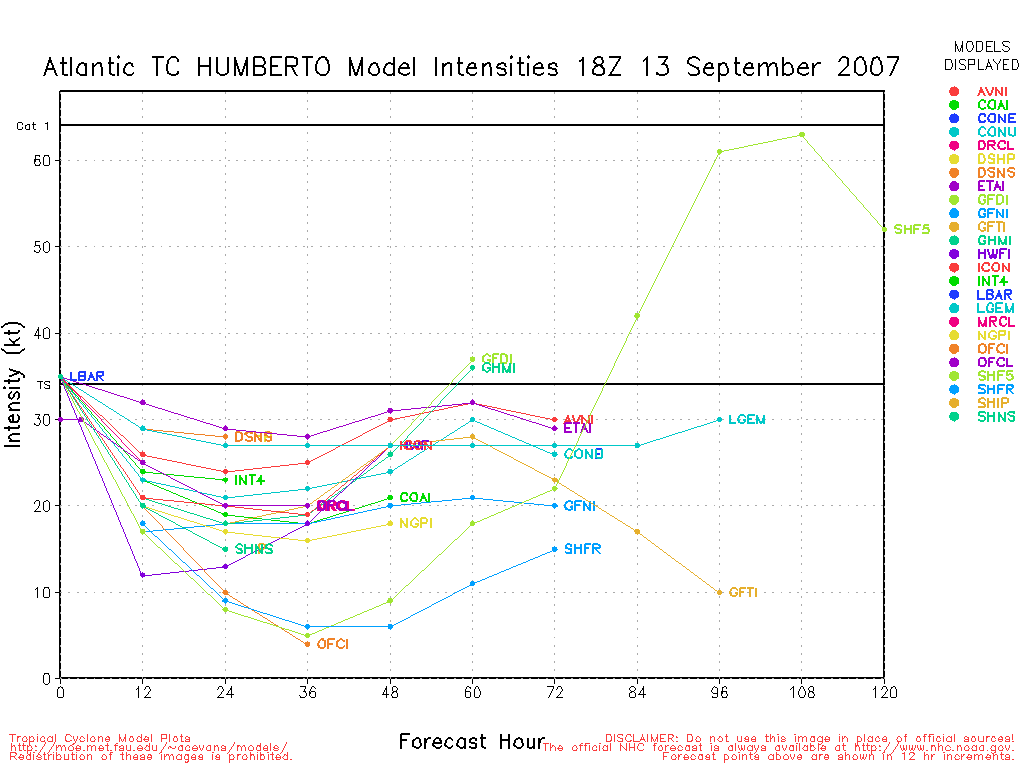
Recon has found a 992mb minimum central pressure in Humberto, but more importantly a very small area of hurricane-force winds at 850mb and at the surface. Thus, Humberto becomes the season's 3rd hurricane just hours before landfall in extreme eastern Texas. A special advisory package from the has all of the particulars. Still, given the very small size of the wind field, rain is the primary threat from Humberto outside of those still in mobile homes after in 2005.
4:50 PM EDT 12 September Update
Recon has found Humberto with pressures of 999mb, and a banding eyewall trying to form. This may wind up being a surprise to those in Houston if it gets itself together. 50MPH winds at the 5PM advisory.
2:35 PM EDT 12 September Update
Recon is finding estimated surface winds around 50-55MPH in Humberto along the Northeastern side. Humberto is a small system and it seems it is consolidating toward the center, keeping the rainfall away from Houston... at the present time. The rain will move closer later tonight.

A 60-65mph storm at landfall is not out of the question, but the primary concern is and still would be rainfall. It is likely to surprise quite a few folks in the area, however. Dry air around the system (entering from the south) should stop it short of very rapid intensification. It may be wise for some folks to prepare for a strong Tropical Storm if they are in and just to the east of the projected landfall locations.
1:53 PM EDT 12 September Update
Tropical Storm Humberto has formed from Tropical Depression #9, still moving slowly northward at 6MPH.
Tropical Storm Warnings are still up. Rain, some wind, and weaker Tornadoes are possible in Texas/Louisiana as it nears.
10:45 AM EDT 12 September Update
TD#8 out in the Caribbean is moving west northwest at 12mph, slower than most systems. It is forecast to stay fairly weak because of shear it is likely to encounter. The current forecast has it still east of the Islands 5 days out, so it would be a good while before it approached here, if at all. Because of the slow movement it is more likely to avoid landfall (more opportunities for it to be picked up), but by no means is it a sure thing. Something to watch over the long term. Guesses on what it'll do, let us know here.
TD#9 in the Gulf is going to be a big rain maker, Tropical Storm Warnings are up for TD#9 from Port O'Connor, TX east to Cameron, LA..
10:00 AM EDT 12 September Update
Double whammy formation. Tropical Depression #8 forms east of the Caribbean from 91L. At 12/12Z the Invest location was 13.1N 44.2W, movement to the west northwest at about 10 knots, pressure 1007mb and winds at 30kts gusting to 40kts. Excellent outflow developing in all quadrants - likely to become the next named storm.
Tropical Depression #9 forms in Gulf of Mexico from 90L. At 12/12Z the Invest location was 27.8N 95.2W. TD is drifting to the west northwest to northwest, pressure also at 1007mb and winds of 25kts gusting to 35kts. TD #9 is not as well organized as TD #8, so additional development, if any, will be a little slower, but still possible given the very slow forward speed. Another round of significant rainfall for the Texas coast.
Advisories for both systems should start at 11AM EDT.
Yet another wave moved off the coast of west Africa last night - located near 11N 21W at 12/12Z. This system has potential for additional development in 3 or 4 days as it moves slowly westward.
8:40 AM EDT 12 September Update
The system slowly moving northward off the Texas coast (90L) is looking better now this morning and may form into a depression today. Recon is scheduled to go out into this system later today. More to come on this system later. It is expected to bring more rain to Southeastern Texas and parts of Lousiana, regardless if it develops or not.
91L east of the Caribbean is looking very good this morning and will also likely form into a depression today. Still too early to tell where it will wind up, however.
Original Update
The wave in the Central Atlantic (east of the Caribbean, also known as 91L) is looking much better tonight and may form into a depression tonight or (more likely) within the next day or so.

This wave is moving mostly west now, model projects having it turning more northwest then back west, nearing the northern Leeward islands. There is plenty of time to watch this system however, as it is a bit south of model projections. Long range is more difficult, but right now all indications are that this one may not be a west mover like Felix and Dean.

Convection is over the low level center, T numbers are around 1.5 (which may support a Tropical Depression) and is set to get stronger.
91L Development chances within next 48 hours
Code:
(forget it) 0 1 2 3 4 5 6 7 8 9 10 (sure thing)

            [----------*---------]
The wave in the Gulf (90L) is nearing the Texas coastline, and is a bit too unorganized to really form into much. Likely just more rain for Texas. It has stalled however, off the coast, so it may have a small chance to form into something before landfall.
Houston, TX Radar Radar Loop
(Latest Static)
Lake Charles, LA Radar Radar Loop
(Latest Static)
New Orleans, LA Radar Radar Loop
(Latest Static)
StormCarib Reports from the Caribbean Islands
Caribbean Weather Observations
Barbados Brohav Weather Fax
Full Caribbean Radar Composite
Caribbean Broadcast Corporation (TV/Radio from Antilles)
San Juan, PR NWS Page
Various Caribbean Radio Stations
DR1 Dominican Republic Hurricanes
Tropical Depression #8 Event Related Links


SFWMD Model Plot (Animated Model Plot) SFWMD Hurricane Page
[https://flhurricane.com/floatanimator.php?year=2007&storm=8 Flhurricane Satellite Floater Animation of TD#8
GOES Floater
Animated Model Plot of TD#8
Clark Evans Track Model Plot of TD#8
(Animated!) Model Plots in Google Earth - In Google Maps
Clark Evans Intensity Model Plot of TD#8 (Animated!)
Clark Evans Track Plot of TD#8
Other Model Charts from Clark
Clark Evans Top 10 Analog Storms for TD#8
More model runs on from RAL/Jonathan Vigh's page
NRL Info on TD#8 -- RAMMB Info
COD Atlantic Satellite View
Humberto Event Related Links


SFWMD Model Plot (Animated Model Plot) SFWMD Hurricane Page
[https://flhurricane.com/floatanimator.php?year=2007&storm=9 Flhurricane Satellite Floater Animation of Humberto
GOES Floater
Animated Model Plot of Humberto
Clark Evans Track Model Plot of Humberto
(Animated!) Model Plots in Google Earth - In Google Maps
Clark Evans Intensity Model Plot of Humberto (Animated!)
Clark Evans Track Plot of Humberto
Other Model Charts from Clark
Clark Evans Top 10 Analog Storms for Humberto
More model runs on from RAL/Jonathan Vigh's page
NRL Info on Humberto -- RAMMB Info
COD Atlantic Satellite View
Edited by Clark (Thu Sep 13 2007 11:27 PM)
|
allan
Weather Master

Reged: Thu
Posts: 468
Loc: Palm Coast, Florida
|
|
As I been predicting, either late tonight or tommorrow morning, I am now convinced that this will be a TD at 5 a.m. tommorrow morning. The reason why i'm holding off till then, is because the circualtion is half exposed. The IR shows one lima bean looking blow up to the west, and a nice banding of clouds to the east.. needs more to go before we can pull the trigger. 
5 or 11 a.m. tommorrow, I am confident
--------------------
Allan Reed - 18,9,5
Edited by allan (Tue Sep 11 2007 10:43 PM)
|
scottsvb
Weather Master
Reged: Mon
Posts: 1184
Loc: fl
|
|
91L current isnt closed but its close,,, data being recieved show a open trough but a well defined midlevel circulation. If convection persists into the morning then a chance for a TD will be issued at 11am or 5pm on Weds. Persistant convection around the developing center is the key..and if it shows that..we will know the circulation is well definded at the surface. Usually mid level circulations will lose their convection after 12hrs near the center.
|
flnelson
Registered User
Reged: Mon
Posts: 3
|
|
In looking at the 00:00Z forcast tracks at:
http://moe.met.fsu.edu/~acevans/models/al912007.png
I see that the models are in tight concensus until the storm reaches 18N when they seem to be evenly split between a more northward and a more westward track.
This seems to coincide with the plots from 18:00Z at:
http://www.skeetobiteweather.com/picservice.asp?t=m&m=91
where the is making a jaunt to the left.
There's a lot to be learned from these storms in their infancy.
As of 11PM Eastern I can see that there is significant convection developing in the northern and western quadrants of the storm plus some early indications of banding. I would concur that this storm should be a TD no later than 11am Eastern tomorrow.
|
cieldumort
Moderator

Reged: Mon
Posts: 2305
Loc: Austin, Tx
|
|
Oh I'm up late tonight, as I suppose many a tracker is here in Texas right now.
Looks like we have one and a half tropical cyclones on our hands tonight. I'm behind the analysis provided above in regards to 91L, and basically believe that if it was within recon range we would have ourselves an officiated TD on this one by noon today. Might happen just the same, even if does often like to give the features still out in the wide blue yonder the unbenefit of the doubt.
90L, 90L. This one is knock knock knocking up against the Texas shores tonight, and environmental conditions for further development, as has its appearance, have only improved yet more. Numerous AFDs are now strongly hinting that it may easily earn a number before moving inland, as have several of our areas OCMs. I've got it up at a 50% chance in my blog now, and feel this may even be conservative. Just too close to call due to proximity to land... but, 90s forward motion seems to have come to a crawl, if not a near-stall, overnight. Being held back a bit by the front, maybe even getting that little extra necessary synoptic kick from interaction with the front, while wind shear has -really- dropped and upper-level winds have now turned somewhat anti-cyclonic overhead.
Tonight marks the first night that pressures within the sphere of 90L have been notably dropping -while- convection has been notably increasing about the surface trough/low. Surface obs, scatterometer, and area radars strongly suggest the presence of an elongated (NNE-SSW) surface low that is consolidating the closer it gets to the coast. Observed max. sustained winds at elevations under 35 feet are now up to as high as 25+ MPH.
At the very least, barring a sudden weakening of either of these invests (90 & 91) I fully expect we'll see s up on them today. (At the very least.) It's mid-September during a season that has already proven to be above-average, and heading into its second half with a developing La Nina. This should not be surprising.
|
punkyg
Weather Watcher

Reged: Sun
Posts: 44
Loc: sanford, florida
|
|
Oh man this has gotten way better organized. it could possibly be a tropical storm for all we know.
http://www.ssd.noaa.gov/goes/east/catl/rb-l.jpg
okay people lets start saying when it will develop.
cause i said on another site it would develop today at 5pm.
i wanna ask yall do you think it has a chance to effect the bahamas.
|
Beaumont, TX
Storm Tracker
Reged: Tue
Posts: 318
|
|
This low in the Gulf is already bringing us too much rain. Texas has had way too much rain this summer. 91L looks good this morning.
In fact, both systems look pretty good. Well, whether 90L forms into a depression or not the results are still the same...rain.
|
Ed in Va
Weather Master
Reged: Fri
Posts: 489
Loc:
|
|
My money is on a depression at 11 am. Regarding the Bahamas, too early to tell. Most long range thinking it will go NW for several days and then more westerly, which would probably take it quite a bit south of there. Moroever, there is a lot of shear forecast by the weekend, which could really affect its development.
--------------------
Survived Carol and Edna '54 in Maine. Guess this kind of dates me!
|
Lee-Delray
Weather Master

Reged: Thu
Posts: 429
|
|
Looking at the major models, I see 91L going NW, then W right before the Bahamas. What is causing this? Also what is the shear forcast in the area for this weekend?
|
OUSHAWN
Weather Guru
Reged: Tue
Posts: 101
Loc: Clear Lake,Tx
|
|
NRL has "08Noname" up on their site now but I'm not sure exactly which one of the systems they are talking about...Gulf or Lesser Ant. sysytem. Looks like the Gulf system, which ironically enough is sitting in the same position that Allison was back in '01, could already be a depression...just from satellite presentation.
Shawn
|
7 Deadly Zins
Verified CFHC User
Reged: Sun
Posts: 12
Loc: Nashville, TN
|
|
Both 90L and 91L are now tropical depressions per the .
91L is tropical depression 8. 90L is depression 9.
Looks like the system in the Atlantic, 08L, is moving due west. Will have to see if this trend continues. Also might be moving a little faster.
|
JayJ
Unregistered
|
|
Noname 8 and 9 up on the .
|
Ed in Va
Weather Master
Reged: Fri
Posts: 489
Loc:
|
|
Here's a good discussion about the future track:
http://crownweather.com/tropdisc.html
--------------------
Survived Carol and Edna '54 in Maine. Guess this kind of dates me!
|
Lee-Delray
Weather Master
Reged: Thu
Posts: 429
|
|
8 is or was 91L
9 is or was 90l
|
Ed in Va
Weather Master
Reged: Fri
Posts: 489
Loc:
|
|
Interesting...a couple models loop the GOM storm back into the Gulf. Waiting for the track.
--------------------
Survived Carol and Edna '54 in Maine. Guess this kind of dates me!
|
OUSHAWN
Weather Guru
Reged: Tue
Posts: 101
Loc: Clear Lake,Tx
|
|
Looks like TD9 in the Gulf is really trying to get its act together. Storms are really staring to fire up right around where the center is and it is moving so slowly and wind shear is pretty low so it may have a chance to become a pretty strong tropical storm before it's all said and done. We know how warm the water is rightoff the coast here. The thing that scares me is the slow movement...it means there could be some major flooding problems here...again.
Shawn
|
stormchazer
Storm Tracker

Reged: Tue
Posts: 315
Loc: Central Florida
|
|
Quote:
Here's a good discussion about the future track:
http://crownweather.com/tropdisc.html
Crown's forecast seems to run contrary to Dr. Jeff Masters blog today.
Dr Jeff Master's Blog
Quote:
The big question concerns the track--there is a good chance that 91L will miss the Lesser Antilles, as the current steering currents favor a more northwesterly track for the storm over the coming days. The system has already moved north of Barbados' latitude, and the southern Lesser Antilles Islands are unlikely to receive a direct hit from 91L. Most of the models indicate a forward speed near 10-15 mph, which would bring 91L to the northern islands Monday. The U.S. East Coast may be at risk from this storm ten or so days from now, but it is far too early to speculate on the chance of this occurring, or what region might be most at risk.
It will be interesting to see what plays out.
--------------------
Jara
*************************************************************
|
Ed in Va
Weather Master
Reged: Fri
Posts: 489
Loc:
|
|
Wunderground now has info up on 8 and 9 (scroll down):
http://www.wunderground.com/tropical/
Check out the climatrology under the tracking map. Most were fish spinners. Only one made it west of FL.
--------------------
Survived Carol and Edna '54 in Maine. Guess this kind of dates me!
Edited by Ed in Va (Wed Sep 12 2007 10:52 AM)
|
MikeC
Admin
Reged: Sun
Posts: 4543
Loc: Orlando, FL
|
|
TD#8 is moving much slower than most systems out at that longitude, at the rate it's moving it wouldn't be until late next week it could affect anywhere in the US. It'll still be east of the islands on Monday, it seems.
It's going to have a pretty good battle with shear too. Because of all that it's most likely going to be a fish spinner type system, but it'll depend on how conditions are this weekend into next week.
|
Beaumont, TX
Storm Tracker
Reged: Tue
Posts: 318
|
|
We are now under a tropical storm warning. Hopefully, Texas won't get too much rain from this system. Hurricane hunters are going to be
investigating the system.
|


 Threaded


