MikeC
Admin
Reged: Sun
Posts: 4543
Loc: Orlando, FL
|
|
Update - Sunday, 10:00AM EDT
Judging from observations from satellite, it appears that SubTD 10 has developed enough to be considered Tropical or Subtropical storm Jerry. Still no threat to any land.
Advisories beginning at 11 should reflect the new name.
As for the waves, here are development chances since a few asked:
Summary, a few waves to watch, nothing I would consider ominous, and nothing really has all that great a chance to develop.
Chances for Tropical Development of Disturbance in the Gulf (94L) In Next 2 days (Lounge discussion thread here )
Code:
(forget it) 0 1 2 3 4 5 6 7 8 9 10 (sure thing)

            [------*-------------]
Chances for Tropical Development of Wave in Far Eastern Atlantic (96L) In Next 2 days (Discussion thread here.)
Code:
(forget it) 0 1 2 3 4 5 6 7 8 9 10 (sure thing)

            [-----*---------------]
Chances for Tropical Development of Wave East of the Caribbean (97L) In Next 2 days (Discussion thread here)
Code:
(forget it) 0 1 2 3 4 5 6 7 8 9 10 (sure thing)

            [----*---------------]
Update - Sunday, 8:50AM EDT
The quiet first part of the weekend gives way to several systems being actively tracked.
Subtropical Depression 11 formed, but will be no threat to land. It is forecast to become a Tropical Storm, however, and it would have the name of Jerry.
The wave in the west Caribbean will be moving over the Yucatan, but may develop once it gets to the Bay of Campeche. (Lounge discussion thread here )
For the system with the larger near term potential for affecting the Caribbean, the wave east of the Caribbean (97L) will have to be watched for development over the next few days, and potentially here down the road. Watch model trends.. Those in the Windward islands should pay very close attention to developments here (They could happen relatively fast, but right now it's looking more like it won't develop at all). Still the chances of it developing at all are only about 30%.. (Discussion thread here)
Another wave in the far eastern Atlantic (96L) will also have to be watched for down the road. If it persists a few days and maintains itself, a depression is possible out of it too. (Discussion thread here.)

Update - Sunday, 3:20AM EDT
Subtropical Depression 11 has formed in the North central Atlantic west of the Azores, it is expected to move northward and be no trouble for land areas. It may have the potential to reach Subtropical Storm as well, if it did so it would be called Jerry.
National Hurricane Center advisories on Subtropical Depression 11 should begin at 5AM.
Update - Saturday, 11PM EDT
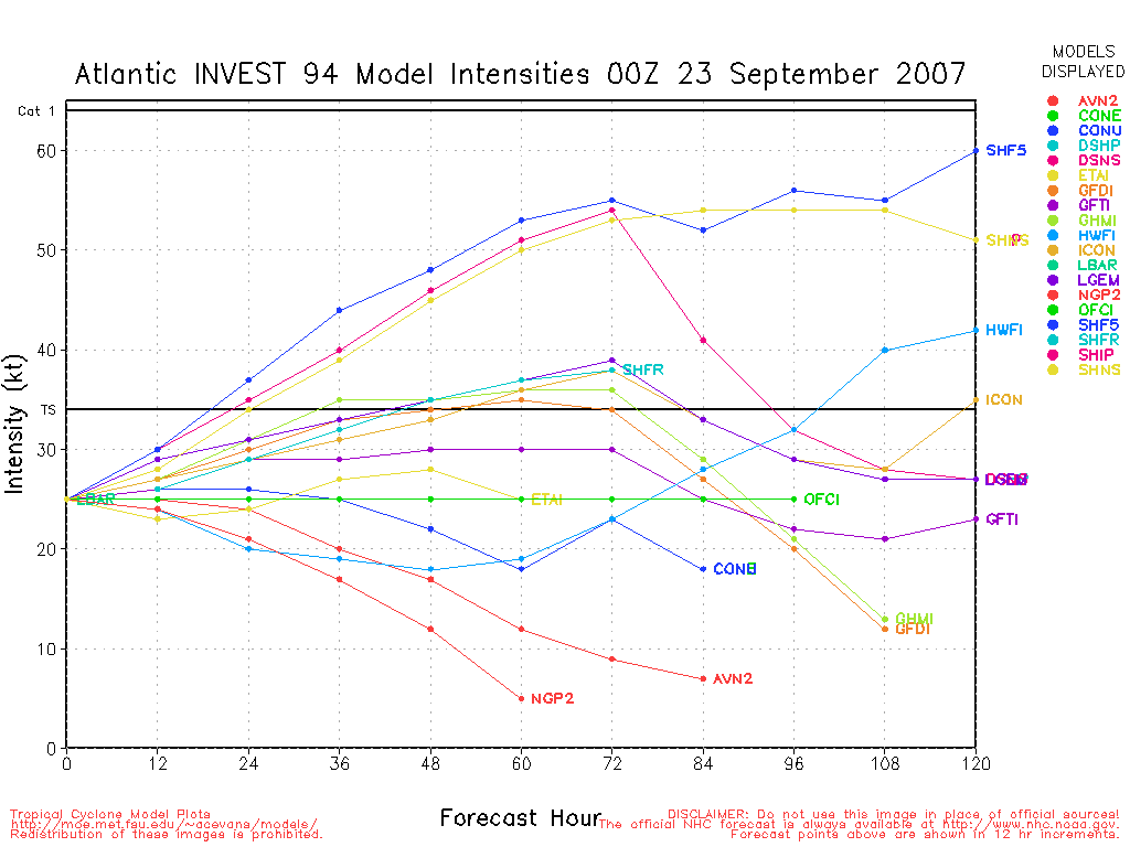
Invest 94L located over the southeast Yucatan near 18.5N 86.3W at 23/00Z and moving slowly to the west northwest with sustained winds of 25 knots. SSTs in the southwestern Gulf of Mexico from 28 to 29C, however, strong southerly shear is building over the western half of the Gulf. Movement to the northwest, and IF the system develops, movement will become westerly - perhaps eventually southwesterly.
Invest 95L located in the central Atlantic near 36.2N 46.3W at 23/00Z moving slowly to the west northwest with sustained winds of 30 knots. SSTs currently a chilly 24C. Eventually an increasing movement toward the north northeast into even cooler SSTs. Although wind shear should remain rather light, significant development is not very likely.
Active tropical wave near 10N 55W at 23/00Z continues to slowly develop in 28C SSTs. System is moving to the west northwest at 10 knots within a zone of light shear. Slow additional development is possible.
Large tropical wave south of the Cape Verde Islands near 8N 24W at 23/00Z moving west at 10 knots under very light shear and SSTs of 27 to 28C. With no significant wind shear in its path for at least the next 5 days, this system has a good chance for additional development.
Lots of areas to keep an eye on in the upcoming week.
ED
Original Post
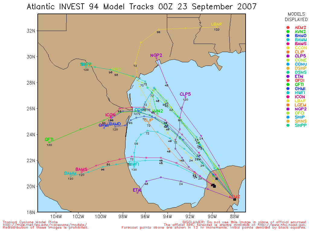
Of all the things in the tropics, a disturbance in the western Caribbean is the most likely to develop, but it may not be until it passes over the Yucatan peninsula and enters the southwestern Gulf. This is now being referred to as "94L".
The most likely scenario is that it crosses the Yucatan, forms into a depression in the Bay of Campeche and then begins moving more northward toward the Texas or Louisiana coastlines as potentially a sheared Tropical storm. This could change, especially if the storm stalls out in the Gulf, but that's the most likely scenario now.
Windshear is also likely to keep this in check from developing too rapidly as well, but time will tell on the system. It's worth watching for those in the Gulf, but I don't expect it to develop before it makes landfall in the Yucatan.
StormCarib Reports from the Caribbean Islands
Caribbean Weather Observations
Barbados Brohav Weather Fax
Full Caribbean Radar Composite
Caribbean Broadcast Corporation (TV/Radio from Antilles)
San Juan, PR NWS Page
Various Caribbean Radio Stations
DR1 Dominican Republic Hurricanes
Tropical Depression 11 Event Related Links


SFWMD Model Plot (Animated Model Plot) SFWMD Hurricane Page
[https://flhurricane.com/floatanimator.php?year=2007&storm=11 Flhurricane Satellite Floater Animation of TD#11
GOES Floater
Animated Model Plot of TD#11
Clark Evans Track Model Plot of TD#11
(Animated!) Model Plots in Google Earth - In Google Maps
Clark Evans Intensity Model Plot of TD#11 (Animated!)
Clark Evans Track Plot of TD#11
Other Model Charts from Clark
Clark Evans Top 10 Analog Storms for TD#11
More model runs on from RAL/Jonathan Vigh's page
NRL Info on TD#11 -- RAMMB Info
COD Atlantic Satellite View
94L (W Caribbean Wave) Event Related Links


SFWMD Model Plot (Animated Model Plot) SFWMD Hurricane Page
[https://flhurricane.com/floatanimator.php?year=2007&storm=12 Flhurricane Satellite Floater Animation of 94L
GOES Floater
Animated Model Plot of 94L
Clark Evans Track Model Plot of 94L
(Animated!) Model Plots in Google Earth - In Google Maps
Clark Evans Intensity Model Plot of 94L (Animated!)
Clark Evans Track Plot of 94L
Other Model Charts from Clark
Clark Evans Top 10 Analog Storms for 94L
More model runs on from RAL/Jonathan Vigh's page
NRL Info on 94L -- RAMMB Info
COD Atlantic Satellite View
96L (East Atlantic Wave) Event Related Links


SFWMD Model Plot (Animated Model Plot) SFWMD Hurricane Page
[https://flhurricane.com/floatanimator.php?year=2007&storm=13 Flhurricane Satellite Floater Animation of 96L
GOES Floater
Animated Model Plot of 96L
Clark Evans Track Model Plot of 96L
(Animated!) Model Plots in Google Earth - In Google Maps
Clark Evans Intensity Model Plot of 96L (Animated!)
Clark Evans Track Plot of 96L
Other Model Charts from Clark
Clark Evans Top 10 Analog Storms for 96L
More model runs on from RAL/Jonathan Vigh's page
NRL Info on 96L -- RAMMB Info
COD Atlantic Satellite View
97L (East of Caribbean Wave) Event Related Links


SFWMD Model Plot (Animated Model Plot) SFWMD Hurricane Page
[https://flhurricane.com/floatanimator.php?year=2007&storm=14 Flhurricane Satellite Floater Animation of 97L
GOES Floater
Animated Model Plot of 97L
Clark Evans Track Model Plot of 97L
(Animated!) Model Plots in Google Earth - In Google Maps
Clark Evans Intensity Model Plot of 97L (Animated!)
Clark Evans Track Plot of 97L
Other Model Charts from Clark
Clark Evans Top 10 Analog Storms for 97L
More model runs on from RAL/Jonathan Vigh's page
NRL Info on 97L -- RAMMB Info
COD Atlantic Satellite View
Edited by Ed Dunham (Sun Sep 23 2007 10:28 AM)
|
HanKFranK
User

Reged: Mon
Posts: 1841
Loc: Graniteville, SC
|
|
system is going over the yucatan. that's one of the more tropical friendly places a system can pass over.. at least for developing stuff. u/a pattern looks ok for the next couple of days, so we could have another of those flash-in-the-pan type systems. models either curve it up or slap it sw into mexico.
pattern might be a little favorable for stuff in the central atlantic to act up, with some ridging building up there. shear in the subtropical atlantic is predicted to reach destructive levels over the next couple of weeks, so any early recurvatures or paths that stray from the deep tropics would likely be suicidal. this time of year the source region for u.s. threats usually shrinks down to caribbean-to-gulf storm tracks. barring anything that might pop up in the bahamas ahead of frontal systems, stuff developing further out in the atlantic is no longer likely to be a threat.
HF 1535z22september
|
punkyg
Weather Watcher

Reged: Sun
Posts: 44
Loc: sanford, florida
|
|
HankFrank do you have anything to say about the area of disturbed weather to the south of the Cape Verde islands?
its looking good.
didn't look out there.. end of september, and i overlooked it. yeah, that one looks decent -HF.
Edited by HanKFranK (Sat Sep 22 2007 09:28 PM)
|
Trekman
Weather Watcher

Reged: Fri
Posts: 32
Loc: Fort Walton Beach FL
|
|
I'll be interested to see what the spaghetti models say for it.
I think we are getting to the time of year to see turns to the north or north-east.
Just my observations from the past on seeing Opal and , and having rode them out.
--------------------
Went though: Erin ('95), Opal ('95), Danny ('97), Georges ('98), Ivan ('04), Dennis ('05)
Emergency Administration and Management program at Northwest Florida State College
|
cieldumort
Moderator

Reged: Mon
Posts: 2305
Loc: Austin, Tx
|
|
The formerly non-tropical Low I've been monitoring out in the north-central Atlantic is doing a fine job of acquiring tropical characteristics, and is now Invest 95L. Additionally, the wave out by the CVs is pretty darn healthy. Potentially another busy week.
For now, 95L will likely remain just a threat to shipping interests, or potentially the Azores, perhaps. Our possible new Invest out by the CVs may be a little more suspect going forward, however.
Of course, close to home, all interests along the Gulf Coast should be watching what is going on with 94L. There is already a fairly impressive surface trough draped from the remnants of 10L which could conceivably interact with the trough that is 94L. Weirder things happen in the tropics. We had remnants of TD10 mix with another disturbance back in 2005, and given that particular environment at that time, was an explosive concoction.
|
danielw
Moderator

Reged: Wed
Posts: 3525
Loc: Hattiesburg,MS (31.3N 89.3W)
|
|
HIGH SEAS FORECAST FOR METAREA IV
NWS OCEAN PREDICTION CENTER WASHINGTON DC
2230 UTC SEP 22 2007 ( 630PM EDT ) (edited~danielw)
ATLANTIC FROM 7N TO 31N W OF 35W INCLUDING CARIBBEAN SEA AND
GULF OF MEXICO
SYNOPSIS VALID 1800 UTC SAT SEP 22
24 HOUR FORECAST VALID 1800 UTC SUN SEP 23
48 HOUR FORECAST VALID 1800 UTC MON SEP 24
.GULF OF MEXICO 12 HOUR FORECAST TROPICAL WAVE S OF 23N ALONG
89W. S OF 23N FROM 86W TO 89W SE WIND TO 20 KT SEAS LESS THAN
8 FT.
.24 HOUR FORECAST NEW LOW PRES 24N90W 1011 MB.
WITHIN 240 NM E SEMICIRCLE E TO SE WIND 20 KT SEAS 8 FT.
.48 HOUR FORECAST LOW PRES 27N94W 1011 MB.
WITHIN 240 NM E SEMICIRCLE E TO SE WIND 20 KT SEAS 8 FT.
************************************
MARINE WEATHER DISCUSSION
NWS TPC/NATIONAL HURRICANE CENTER MIAMI FL
100 PM EDT SAT SEP 22 2007 (edited~danielw)
MARINE WEATHER DISCUSSION FOR GULF OF MEXICO...CARIBBEAN SEA
AND SOUTHWEST NORTH ATLC S OF 31N W OF 55W.
GULF OF MEXICO...
...A SECOND...INVERTED
TROUGH IS ANALYZED S OF 23N ALONG 87W AND IS EXPECTED TO MOVE W
TONIGHT AND SUN WITH SOME MODELS SUGGESTING LOW PRES DEVELOPMENT
ALONG THE TROUGH AXIS. AN UPPER CYCLONE NEAR 27N94W IS MOVING W
ACCOMPANIED BY PLENTY OF UPPER DIFFLUENCE WELL E OF ITS CENTER.
SO I WILL PROG WEAK SURFACE LOW PRES SUN NEAR 24N90W AND MOVE IT
NW TO TX/LA COASTAL PLAINS LATE MON NIGHT/TUE MORNING...BUT
CONTINUE A BROAD LOW LEVEL TROUGH OVER THE W GULF...WITH MEAN
AXIS EXTENDING N-S ALONG 93W...THROUGH EXTENDED PERIOD. MOST
AGGRESSIVE MODEL...SO WILL GO GUIDANCE ON STRENGTH OF
WINDS...AND THUS THE ASSOCIATED SEAS...EXPECTING TIGHTEST
GRADIENT ROUGHLY WITHIN 240 NM E SEMICIRCLE OF THE SURFACE
LOW.
|
cieldumort
Moderator
Reged: Mon
Posts: 2305
Loc: Austin, Tx
|
|
Whatever 94L does, a continued influx of moisture into the GOM, in one form or another, for at least another 30-60 hours looks likely.
Invest 95L is stunning. If this puppy was in the GOM right now we would be having all sorts of recon going on. 25 knots per , and based on the most recent Scat out there, I'll bet dollars to donuts is likely conservative. As a shipping interest only, might be one of those that never gets a bump during the season (left to the High Seas Forecast).. but my best guess would be that because nothing else is out there to earn "Jerry" right now, may go ahead with it (as there is little room for confusion).
So, I would bet at least a few dollars to donuts that Jerry is lurking around the corner in the central Atlantic. Right now.
See for yourself.
|
HanKFranK
User
Reged: Mon
Posts: 1841
Loc: Graniteville, SC
|
|
see what they do at 11. it pulled down an ST2.5 rating, which is usually a solid subtropical storm, and is being analyzed at 1008 mb. kinda wonder what the quickscat vectors on the low level vortex looked like before it went into shelter under the convective burst.
wave 500 mi east of the islands looking meaner tonight. thing in the carib moving landward but due for the gulf... and the cv wave looks like it has a future too. hard to picture it not getting a little busy this week, though i said the same thing a week ago and all i got was this 'eat crow' t-shirt.
HF 0132z23september
|
Clark
Meteorologist
Reged: Wed
Posts: 1710
Loc:
|
|
Not too keen overall on 94L, not at least for the next couple of days. Upper level pattern will be okay, not overly favorable or unfavorable; watch to see if any small troughs form along that moisture axis currently extending from the Gulf of Tehuantepec to Florida -- it has shown a tendency to spin up a few shortwaves the past couple of days. Agree overall with HF that it might be another flash-in-the-pan type of system as it generally heads northwest along the eastern edge of the upper trough currently over Mexico and the western Gulf of Mexico.
Where it goes from there depends at least partially upon whether or not that trough along the California coast captures it as it ejects northeastward over the next couple of days. If it doesn't get picked up and sent to Texas, a westward movement would be likely; I don't buy the sharp southwestward turn shown primarily by the HWRF. A few days to watch it overall, with focus from the TX/LA border southward.
95L is the more imminent development threat, looking like some of our higher latitude developments from 2005. Cyclone phase analyses from the various models are in consensus on this being right on the cusp of a tropical-like thermal structure. Satellite appearance suggests at least a subtropical structure, although it may not quite be fully detached from its parent trough. Thus, I don't expect it to be classified at 11pm, but if current trends hold overnight I do expect some classification by 11am tomorrow. (Note that the current intensity estimate in the best track file is 30kt.) It has another 24 hours or so to develop before it begins to accelerate to the north and east in advance of the trough exiting New England/Canada.
The features in the tropical Atlantic are interesting but have a long road ahead of them. The one near the Cape Verdes is probably the best organized of the two and is located at a fairly low latitude, perhaps allowing it to miss the brunt of the westerlies in the short term. The one closer to the islands is stuck in a weak-moderate dust outbreak, though that doesn't seem to be hindering it right now. It might largely be flaring up in response to the diffluent upper level environment over it thanks to the tail-end of the trough associated with 95L. Expect it to trudge west over the next few days, probably following the cell in the Central Caribbean. As mentioned above, it's interesting, but it's not an imminent threat -- if it ever becomes one at all.
African wave chain doesn't look all that impressive and we really are starting to move out of Cape Verde season. It produced a few storms -- Dean and Felix notable amongst them -- but the upper level pattern throughout the first half of the season never allowed any to form or track far enough north to become a threat to the United States. Quite the peculiar oceanic conditions north of about 12-13N near the Cape Verdes this year. That, along with the abnormally low tropical activity across the northern Hemisphere basins this year (4 in the N. Indian, 9 each in the Atlantic and E. Pacific so far, 13 in the W. Pacific), will be interesting areas of research as we move into the off-season.
--------------------
Current Tropical Model Output Plots
(or view them on the main page for any active Atlantic storms!)
|
cieldumort
Moderator
Reged: Mon
Posts: 2305
Loc: Austin, Tx
|
|
NHC was crystal-clear at 11PM regarding 95L:
(Re: 95L) 2. SATELLITE IMAGES INDICATE THAT THE NON-TROPICAL LOW LOCATED ABOUT
850 MILES WEST-SOUTHWEST OF THE AZORES IS ON THE VERGE OF BECOMING
A SUBTROPICAL OR TROPICAL CYCLONE.
Looks as good as any emerging high-lat system from 2005 tonight. 2345Z SSD gave it a ST2.5 .. probably a little conservative, really. Might just as easily gone T2.5, maybe even 3.0 IMHO. As Clark mentions, the thermal structure is nearly tropical tonight, and it clearly has a mix of subtropical and tropical structures on standard satellite, and a well-formed LLC in the microwave passes. Most recent Windsat had a lot of rain contamination, but some arguably believable 40-45 knot vectors. Perhaps a good bit stronger up around 925mb, however the convection appears a touch soft yet to bring those down to the surface.
Our 94L is going to have to deal some with land. As Clark points out, the entire stretch of the moisture plume associated with 94L and the remnant trofiness of TD10 has been the focus of a few weak spins. Looks to me that 94L, as it is being tracked, still has the best potential of the entire slew of lower pressures, vorticity, and moisture influx in that area. strongly hints at the potential for the environment in the GOM to become conducive once it gets over the Yucatan:
(Re: 94L) UPPER-LEVEL WINDS
ARE FAVORABLE FOR SOME DEVELOPMENT WHEN THE LOW EMERGES
OVER THE GULF OF MEXICO WITHIN THE NEXT 24 HOURS.
Suspect that the models have it generally right with 94L - expect a continuation of a generally west-northwest to northward course. Even if this does not develop, Texas -does-not-need-any-more-rain-, and so a healthy tropical wave has the capacity to create a lot of ruckus over here, all on its own.
A bit surprised we do not yet have invest tags up on the two waves. The one 500 or so south of the Cape Verdes features a well-defined, yet still broad, surface low, and is another one of those way-out systems recon would be all over if closer to shore. Looking forward to seeing tags on both, and to read what kind of numbers they are pulling from the agencies. Looks like both would earn a solid T1.0 tonight, at a minimum, as it were.
|
cieldumort
Moderator
Reged: Mon
Posts: 2305
Loc: Austin, Tx
|
|
95L is now 11L.
(LINK)
Official current intensity, track, and intensity forecasts will be issued soon.
The CV wave has been tagged - 96L. At 0600Z SSD estimated it T1.0
Hopefully we're treated to some closer images and microwave passes soon.
|
cieldumort
Moderator
Reged: Mon
Posts: 2305
Loc: Austin, Tx
|
|
Wave east of the Antilles is indeed now 97L.
Looks like we might have to add this one in addition to 94L as something of a potential upcoming threat to land. Post-eclipse satellite glimpses look fairly impressive, and it is just about knocking on the door of the eastern Caribbean. Might be there by Monday morning.
NRL - 97L Link
(Off topic comments removed.)
Edited by Ed Dunham (Sun Sep 23 2007 10:38 AM)
|
oil tracker
Registered User
Reged: Thu
Posts: 8
|
|
NRL right now is showing 5 systems in a row for the Atlantic Ocean and 2 more systems for the Pacific.
By the way, which one additionally to L94 that can landfall in Texas, could reach and become serious danger for GOM? L95 is too high, and looks like to turn north very soon looking at track. So my question left for L96 and L97. Are there models yet showing any forecast on the tracks of those disturbances?
L94 must be now over BOC. So; next models´ plot will be very interesting. However doesn’t put much emphasis on this, little time to cook something big.
(Off topic 'temptation' corrected.)
Edited by Ed Dunham (Sun Sep 23 2007 10:34 AM)
|
Rich B
British Meteorologist
Reged: Sat
Posts: 498
Loc: Gloucestershire, England, UK
|
|
Well now has 11L up as 'Jerry'. SSD also gave TNumbers of ST2.5/ST2.5 a few hours ago. Based on this i would imagine we probably have Subtropical Storm Jerry as of the 15z advisory package.
--------------------
Rich B
SkyWarn UK
|
OUSHAWN
Weather Guru
Reged: Tue
Posts: 101
Loc: Clear Lake,Tx
|
|
I'm not putting much stock in 94L developing. For one, the is the ONLY ones I have seen that have said conditions are favorable for development but I think they will change their thinking on that very soon. Also, the conditions would have to be ideal since it won't have much time over water to begin with. Looks like most of the rain will stay to the east of us here in the Houston area as well.
Shawn
|
Hugh
Senior Storm Chaser
Reged: Fri
Posts: 1060
Loc: Okaloosa County, Florida
|
|
Looking at the Gulf visible satellite and the NOLA radar, it appears that 94L is *trying* to develop. Whether it has timeto actually develop or not, remains to be seen (kinda doubtful in some ways).
--------------------
Hugh
Eloise (1975) - Elena and several other near misses (1985) - Erin & Opal (1995) - Ivan (2004)
|
OUSHAWN
Weather Guru
Reged: Tue
Posts: 101
Loc: Clear Lake,Tx
|
|
I'm expecting the to cancel the RECON for 94L...not seeing anything that would cause them to go ahead with the scheduled flight. Looks like the sheer as well as the timing will prohibit 94L from being able to do anything. Hopefully it will provide some parts of the SE with much needed rainfall.
Shawn
|
Hugh
Senior Storm Chaser
Reged: Fri
Posts: 1060
Loc: Okaloosa County, Florida
|
|
There certainly is some shear, but it does look to me like there is a bit of a twist to the clouds as well. The majority of the convection is displaced from what might be a swirl, though, which is just emerging off the Yucatan. It's gong to bring LOTS of rain to the central Gulf today and tomorrow, regardless of development.
--------------------
Hugh
Eloise (1975) - Elena and several other near misses (1985) - Erin & Opal (1995) - Ivan (2004)
|
BLTizzle
Verified CFHC User

Reged: Sat
Posts: 13
Loc: Eufaula, AL
|
|
The swirl Hugh referred to in the southern GOM has become a little more pronounced. Look around 23N 91W, give or take .5 either way. Looks to be in the mid to lower levels, too. It'll be interesting to see if it can wrap the blob of moisture to its southeast up. The shear has appeared to die down a bit in that immediate area as well.
--------------------
Brandon in Eufaula, AL - experienced TS Alberto ('93) Opal ('95), Georges ('98), Ivan ('04), Katrina ('05) (I was in Tuscaloosa AL roughly 70 miles SSE of Columbus, MS)
Edited by BLTizzle (Sun Sep 23 2007 08:03 PM)
|
Hugh
Senior Storm Chaser
Reged: Fri
Posts: 1060
Loc: Okaloosa County, Florida
|
|
Actually... the swirl I saw (on radar, incidentally) was much further north than 23N. The whole presentation of the system has since fallen completely apart.
--------------------
Hugh
Eloise (1975) - Elena and several other near misses (1985) - Erin & Opal (1995) - Ivan (2004)
|


 Threaded


