Clark
Meteorologist
Reged: Wed
Posts: 1710
Loc:
|
|
1:30AM EDT Update 25 September 2007
The wave in the far eastern Atlantic (formerly 96L) was upgraded to TD 12 at 11p. The official track has it moving west-northwest for the next few days before turning more toward the north-northwest late in the forecast period. Strengthening is likely with this feature, possibly to hurricane strength over the next couple of days. Elsewhere, disturbances 94L and 97L are largely maintaining status-quo early this morning, featuring low-level circulations but not a whole lot of deep convection. Both remain threats for development in the short term, although unfavorable upper level winds may hinder development for one or both of the disturbances.
Jerry was "upgraded" to a tropical storm at 11p, though it had officially degenerated into an open trough of low pressure before the advisory time. It should be absorbed by a strong cold front in the north Atlantic sometime today.
Original Update
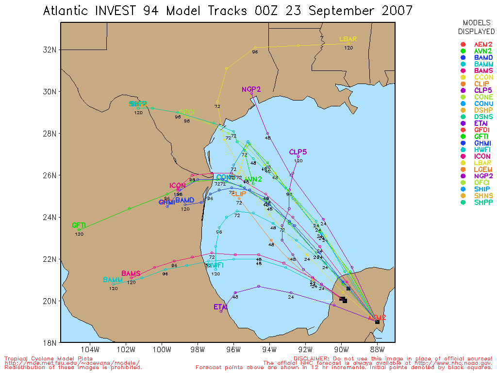
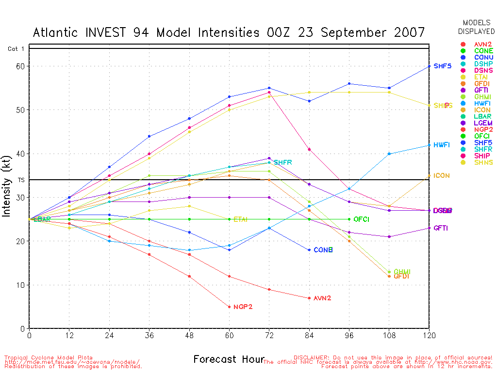
Today two systems are looking better for development, the most immediate concern in the disturbance in the Gulf of Mexico (94L). It may form as early as 5PM tonight into a depression. The current model runs have it moving more westward or even slightly south of due west toward Mexico (not likely for US landfall), and because of the upper air situation, likely no more intense than a Tropical Storm.
96L in the far eastern Atlantic may form tomorrow or the next day as well. Right now it's starting to look better, but the overall circulation remains a bit too broad to be classified.
97L near the Windwards is looking a little better today, but likely won't develop before it gets to the islands, still it must be watched.

Jerry has weakened into a depression and will turn soon.
More to come soon...
Chances for Tropical Development of Disturbance in the Gulf (94L) In Next 2 days (Lounge discussion thread here )
Code:
(forget it) 0 1 2 3 4 5 6 7 8 9 10 (sure thing)

            [--------------*-----]
Chances for Tropical Development of Wave in Far Eastern Atlantic (96L) In Next 2 days (Discussion thread here.)
Code:
(forget it) 0 1 2 3 4 5 6 7 8 9 10 (sure thing)

            [----------*----------]
Chances for Tropical Development of Wave East of the Caribbean (97L) In Next 2 days (Discussion thread here)
Code:
(forget it) 0 1 2 3 4 5 6 7 8 9 10 (sure thing)

            [------*-------------]
Martinique Radar
StormCarib Reports from the Caribbean Islands
Caribbean Weather Observations
Barbados Brohav Weather Fax
Full Caribbean Radar Composite
Caribbean Broadcast Corporation (TV/Radio from Antilles)
San Juan, PR NWS Page
Various Caribbean Radio Stations
DR1 Dominican Republic Hurricanes
Jerry Event Related Links


SFWMD Model Plot (Animated Model Plot) SFWMD Hurricane Page
[https://flhurricane.com/floatanimator.php?year=2007&storm=11 Flhurricane Satellite Floater Animation of Jerry
GOES Floater
Animated Model Plot of Jerry
Clark Evans Track Model Plot of Jerry
(Animated!) Model Plots in Google Earth - In Google Maps
Clark Evans Intensity Model Plot of Jerry (Animated!)
Clark Evans Track Plot of Jerry
Other Model Charts from Clark
Clark Evans Top 10 Analog Storms for Jerry
More model runs on from RAL/Jonathan Vigh's page
NRL Info on Jerry -- RAMMB Info
COD Atlantic Satellite View
94L (Gulf Disturbance) Event Related Links


SFWMD Model Plot (Animated Model Plot) SFWMD Hurricane Page
[https://flhurricane.com/floatanimator.php?year=2007&storm=13 Flhurricane Satellite Floater Animation of 94L
GOES Floater
Animated Model Plot of 94L
Clark Evans Track Model Plot of 94L
(Animated!) Model Plots in Google Earth - In Google Maps
Clark Evans Intensity Model Plot of 94L (Animated!)
Clark Evans Track Plot of 94L
Other Model Charts from Clark
Clark Evans Top 10 Analog Storms for 94L
More model runs on from RAL/Jonathan Vigh's page
NRL Info on 94L -- RAMMB Info
COD Atlantic Satellite View
Karen Event Related Links


SFWMD Model Plot (Animated Model Plot) SFWMD Hurricane Page
[https://flhurricane.com/floatanimator.php?year=2007&storm=12 Flhurricane Satellite Floater Animation of Karen
GOES Floater
Animated Model Plot of Karen
Clark Evans Track Model Plot of Karen
(Animated!) Model Plots in Google Earth - In Google Maps
Clark Evans Intensity Model Plot of Karen (Animated!)
Clark Evans Track Plot of Karen
Other Model Charts from Clark
Clark Evans Top 10 Analog Storms for Karen
More model runs on from RAL/Jonathan Vigh's page
NRL Info on Karen -- RAMMB Info
COD Atlantic Satellite View
97L (East of Caribbean Wave) Event Related Links


SFWMD Model Plot (Animated Model Plot) SFWMD Hurricane Page
[https://flhurricane.com/floatanimator.php?year=2007&storm=14 Flhurricane Satellite Floater Animation of 97L
GOES Floater
Animated Model Plot of 97L
Clark Evans Track Model Plot of 97L
(Animated!) Model Plots in Google Earth - In Google Maps
Clark Evans Intensity Model Plot of 97L (Animated!)
Clark Evans Track Plot of 97L
Other Model Charts from Clark
Clark Evans Top 10 Analog Storms for 97L
More model runs on from RAL/Jonathan Vigh's page
NRL Info on 97L -- RAMMB Info
COD Atlantic Satellite View
Edited by MikeC (Tue Sep 25 2007 01:35 PM)
|
Storm Hunter
Veteran Storm Chaser

Reged: Wed
Posts: 1370
Loc: Panama City Beach, Fl.
|
|
TD 12 is now Karen!  Another one for the record books.... Another one for the record books....
--------------------
www.Stormhunter7.com ***see my flight into Hurricane Ike ***
Wx Data: KFLPANAM23 / CW8771
2012== 23/10/9/5 sys/strms/hurr/majh
|
punkyg
Weather Watcher

Reged: Sun
Posts: 44
Loc: sanford, florida
|
|
So how long will the shear stick around?
do you think it'll get any stronger then 50mph 
will the weakness Karen suppose to move into fill in.
|
Beach
Weather Guru

Reged: Wed
Posts: 187
Loc: Cocoa Beach/Banana River
|
|
Take a look at: http://www.ssd.noaa.gov/goes/east/watl/loop-wv.html
Any thoughts on the disturbed weather approaching Nassau?
Doesn't it look like there is rotation?
|
OUSHAWN
Weather Guru
Reged: Tue
Posts: 101
Loc: Clear Lake,Tx
|
|
Looks like 94L is getting better organized by the minute. It's still facing some shear but doesn't appear to be near as much as the moisture that was shooting off to the north has now decreased and the storms are firing up around what appears to be the new center. I know RECON is on standby but feel they will go out to investigate later. Any thoughts?
Shawn
|
LoisCane
Veteran Storm Chaser

Reged: Fri
Posts: 1236
Loc: South Florida
|
|
Dirty side of an upper level low in the Bahamas I would say... sure a lot of constant rain in miami but pressures still high here..
But anytime you have this much rain would keep watching. I know the Canadian has pulled a storm out of his hat in the Keys but.. that would come from the SW not the SE..
Actually wind right now here is zero and pressure 29.88 so maybe worth watching close in while staring at Karen far out
--------------------
http://hurricaneharbor.blogspot.com/
|
OUSHAWN
Weather Guru
Reged: Tue
Posts: 101
Loc: Clear Lake,Tx
|
|
I am very surprised at the lack of activity on this board today considering all the action we have going on in the tropics. Where is everyone? We have Karen out there and are about to have TD#13 with the GOM system. I'm very disappointed in you guys...lol.
Shawn
|
scottsvb
Weather Master
Reged: Mon
Posts: 1184
Loc: fl
|
|
Well there isnt alot to talk about really as a "threat" to the U.S. but there is alot of weak activity. Karen has many days togo...she doubtfully will be a hurricane soon but there is a chance if she fights off enough shear. 97L is a small low...they could call it a TD at any time..but at the same time...it could be nothing. 94L in the western gulf should persist and may become a Tropical storm..but after the mid-continental trough slides to the east coast..ridging behind this should take this system into Mx. Finally mid level trough over the Fl straits may make it down to the surface in a day or 2 but will most likely just make S Florida Wet.
|
LoisCane
Veteran Storm Chaser
Reged: Fri
Posts: 1236
Loc: South Florida
|
|
I'm actually curious why they even added in the line "no immediate threat to land"
sort of was obvious, why highlight something so obvious
when are they sending planes into it?
--------------------
http://hurricaneharbor.blogspot.com/
|
Thunderbird12
Meteorologist
Reged: Thu
Posts: 644
Loc: Oklahoma
|
|
94L seems to be doing what it did yesterday... flaring up in the morning and then losing momentum in the afternoon. Deep convection has weakened near the center and there is still plenty of southerly shear over the system, thanks to a small mid-level low just to its NW. Still, it will be interesting to see what the plane finds in there.
|
WeatherNut
Weather Master
Reged: Wed
Posts: 412
Loc: Atlanta, GA
|
|
As far as Karen goes...this storm has a much larger size than most we've seen this season. Will this size come into play more in turning this system? I know in basic physics it takes more energy to change the path of a larger object than a smaller one (I think...been a while since I was in high school). Does this translate into larger storms?
--------------------
Born into Cleo (64)...been stuck on em ever since
|
madmumbler
Storm Tracker

Reged: Wed
Posts: 324
Loc: SWFL
|
|
Quote:
I'm actually curious why they even added in the line "no immediate threat to land"
sort of was obvious, why highlight something so obvious
Because there are a lot of people with no conception as to how big and wide "the pond" is out thar. *LOL* I mean, look at the periodic discussions that happen when they put the, "elsewhere, tropical storm formation is not expected" tag on things and people read into it that it means there absolutely WILL be development because they specified that elsewhere there won't be.
The just has to cover as many bases as they can with the general public.
--------------------
Lesli in SWFL.
Friends help you move. Real friends help you move bodies.
|
WeatherNut
Weather Master
Reged: Wed
Posts: 412
Loc: Atlanta, GA
|
|
The area over the Bahamas does not look like an ULL to me. In fact, its got some pretty good outflow starting to set up on the north side, which would indicate an upper high developing over it...at least thats what it looks like on water vapor ...but I am no expert
--------------------
Born into Cleo (64)...been stuck on em ever since
|
cchsweatherman
Weather Watcher
Reged: Tue
Posts: 34
|
|
Long time since I have posted here.
I have been talking with people on Wunderground and we are all in agreement that we may have something developing just south of the Bahamas. On the latest loops, you can clearly see what appears to be either a low level or mid-level circulation forming in this area. Showers and thunderstorms have been increasing in this area all day long, so it will have to be monitored for tropical development. This could be the system developed by the .
I also wanted to comment on Karen. Despite the current projected path, I do not believe that we will see a curvature of Karen out to sea. It appears from the latest models and steering patterns that the high may be getting stronger that originally thought and that the troughs will be weaker. This is a scary premonition and will need to be watched. The latest UKMET, , and now even models all show a more westerly movement than in the previous runs. Noone should let their guard down on any of these systems out there, but in my opinion, 94L poses the least threat to the United States.
|
danielw
Moderator

Reged: Wed
Posts: 3525
Loc: Hattiesburg,MS (31.3N 89.3W)
|
|
TROPICAL DISCUSSION - INTERNATIONAL DESKS
NWS HYDROMETEOROLOGICAL PREDICTION CENTER CAMP SPRINGS MD
212 PM EDT TUE SEP 25 2007 (excerpts only)
...AT LOW LEVELS...IT REFLECTS AS AN ILL ORGANIZED LOW NEAR 21N 94W...WHERE IT IS NOW EXPECTED TO MEANDER THROUGH 72 HRS.
THE MODELS STILL FORESEE LITTLE CHANGE IN INTENSITY...AND THE IS NOT EXPECTING IT TO
EVOLVE INTO A TROPICAL STORM.
BUT THE STILL SHOWS SLOW EVOLUTION TO A WEAK SUBTROPICAL CYCLONE.
FARTHER EAST...WATER VAPOR IMAGERY SHOWS A CLOSED UPPER LOW NEAR 29N/ 74W ... SUPPORTING A TROUGH INTO FLORIDA/ NORTHERN BAHAMAS. THE SYSTEM IS CUTOFF FROM THE FLOW... AND IT IS EXPECTED TO WEAKEN TO AN OPEN TROUGH ALONG 80W BY 48-60 HRS. THROUGH 72 HRS IT IS EXPECTED TO NEARLY FILL.
AT MID/LOW LEVELS IT WILL SUPPORT A
TROUGH ACROSS THE NORTHWEST BAHAMAS TO WESTERN CUBA... WHERE IT IS EXPECTED TO PERSIST DURING THE NEXT THREE DAYS. THE TROUGH IS TO CONTINUE ENHANCING DEEP CONVECTION ACROSS THE NORTHWEST AND
CENTRAL BAHAMAS.
TROPICAL DISCUSSION
http://www.hpc.ncep.noaa.gov/html/discuss.shtml
|
cieldumort
Moderator

Reged: Mon
Posts: 2305
Loc: Austin, Tx
|
|
Regarding the clouds and showers down around the Straits of Fl... it does look like there might be something setting up in the mid levels, but surface pressures are running average to a tad high, and if anything, have been on a slow increasing trend. If anything was to take at the surface here it would almost certainly be a slower process. A couple of the hotter model runs want to cook something up out of it, but then again they're running hot, and so show a lot of cooking all over the place. Still wouldn't be surprised to see it Invest tagged should the convection persist and something of a surface reflection actually get going. It's mighty close to home.
NHC just got a vortex out of 94L. Might just -barely- qualify as a TD, but this low is still battling a good bit of dry, stable air from its west, a weak, yet competing mid-level low to its north, and shear. Almost impossible to make a case for any kind of real strengthening in the near term, regardless.
|
allan
Weather Master

Reged: Thu
Posts: 468
Loc: Palm Coast, Florida
|
|
If you've read my post on Karen earlier, I was talking about how it may or may not recurve.. the new Euro is out and literally shocks the stuff out of me.. it's been recurving the storm until this new run...
http://www.ecmwf.int/products/forecasts/...s!2007092512!!/
The European model nailed most of the storms this seaons including Dean and Felix.. if this ridge holds strong, we need to be on alert, especially if it's THAT BIG!!
The and has also shifted westward, including a very small westward shift on the
--------------------
Allan Reed - 18,9,5
|
cieldumort
Moderator
Reged: Mon
Posts: 2305
Loc: Austin, Tx
|
|
NWS TPC/NATIONAL HURRICANE CENTER MIAMI FL
530 PM EDT TUE SEP 25 2007
FOR THE NORTH ATLANTIC...CARIBBEAN SEA AND THE GULF OF MEXICO...
DATA FROM THE AIR FORCE RECONNAISSANCE AIRCRAFT INDICATE THAT A
TROPICAL DEPRESSION HAS FORMED IN THE SOUTHWESTERN GULF OF MEXICO.
A SPECIAL ADVISORY WILL BE ISSUED WITHIN THE NEXT HOUR OR SO.
NHC issued maps and advisories for 13 are now up on the upper-left of the main page.
Edited by cieldumort (Tue Sep 25 2007 06:06 PM)
|
Wingman51
Weather Guru

Reged: Tue
Posts: 126
Loc: Orlando, FL
|
|
td 13 advisory just issued :?:
|
M.A.
Weather Guru
Reged: Thu
Posts: 108
Loc: Vero Beach, Fl
|
|
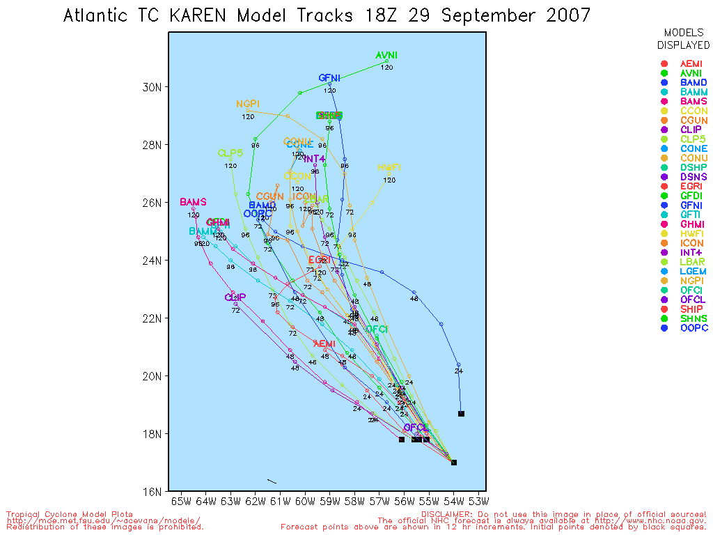
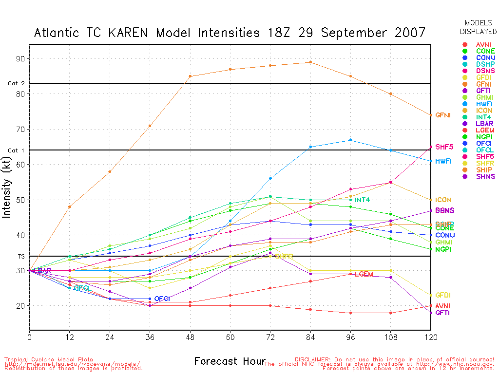
Karen looks to be intensifying. The SE and North quadrants look to be blowing up on the latest sat views. I know that it is not forecast to gain a lot of strenght of the next 120 hrs. But I still have to wonder if this only a feable attempt at intensification or a precurser of things to come if the LLC tightens. She is an absolute massive storm, and it doesnt appear to be under a terrible amount of shear at this point. Any thoughts?
|


 Threaded


