MikeC
Admin
Reged: Sun
Posts: 4543
Loc: Orlando, FL
|
|
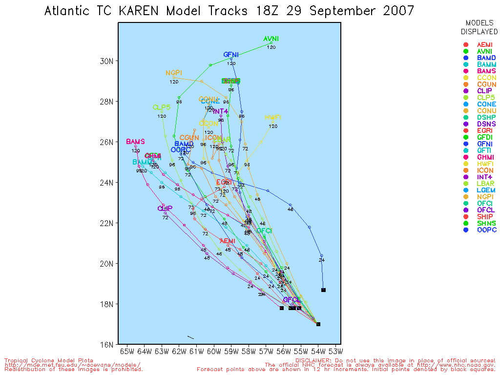
8AM EDT Update 29 September 2007
Tropical Depression #14 becomes Tropical Storm Melissa, with 40MPH winds. It is expected to turn north eventually and out to sea, it, much like Karen, will enter high shear in a few days which may weaken or dissipate it.
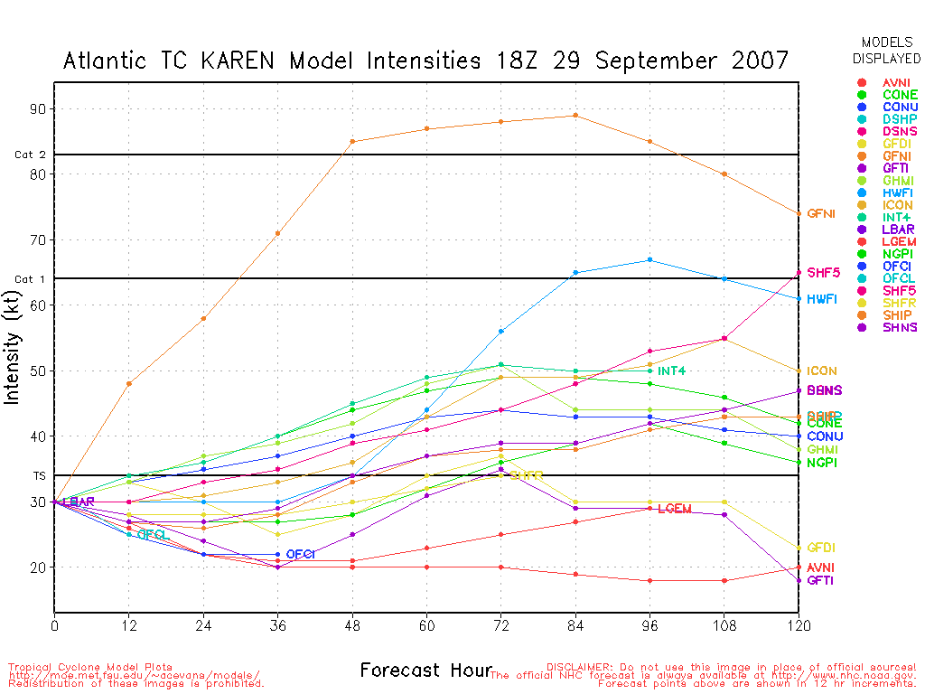
Karen is also undergoing heavy shear, and it's looking more like a tropical wave than a tropical storm this morning. There is a good chance Karen will be considered gone, open up back into an open wave. Two low level circulation centers can be seen on visible satellite imagry. It is very likely Karen has already fallen below depression status.
Conditions improve in a day or so, however.
Original Update
Tropical Depression 14 has formed in the far east Atlantic, from what was a short lived invest 99L that formed this morning. Likely out to sea. More to come on this soon.
Advisories for TD#14 should begin at 11AM EDT.
Hurricane Lorenzo made landfall this morning along the coast of Mexico.
Karen has weakened and may weaken more, it is still most likely to head out to sea, but there are some interesting things going on with it.
More to come soon....
Southeast Composite Radar
Miami, FL Radar Loop
(Latest Static)
Key West, FL Radar Loop
(Latest Static)
Melbourne, FL Radar Loop
(Latest Static)
StormCarib Reports from the Caribbean Islands
Caribbean Weather Observations
Barbados Brohav Weather Fax
Full Caribbean Radar Composite
Caribbean Broadcast Corporation (TV/Radio from Antilles)
San Juan, PR NWS Page
Various Caribbean Radio Stations
DR1 Dominican Republic Hurricanes
Karen Event Related Links


SFWMD Model Plot (Animated Model Plot) SFWMD Hurricane Page
[https://flhurricane.com/floatanimator.php?year=2007&storm=12 Flhurricane Satellite Floater Animation of Karen
GOES Floater
Animated Model Plot of Karen
Clark Evans Track Model Plot of Karen
(Animated!) Model Plots in Google Earth - In Google Maps
Clark Evans Intensity Model Plot of Karen (Animated!)
Clark Evans Track Plot of Karen
Other Model Charts from Clark
Clark Evans Top 10 Analog Storms for Karen
More model runs on from RAL/Jonathan Vigh's page
NRL Info on Karen -- RAMMB Info
COD Atlantic Satellite View
Melissa Event Related Links


SFWMD Model Plot (Animated Model Plot) SFWMD Hurricane Page
[https://flhurricane.com/floatanimator.php?year=2007&storm=14 Flhurricane Satellite Floater Animation of Melissa
GOES Floater
Animated Model Plot of Melissa
Clark Evans Track Model Plot of Melissa
(Animated!) Model Plots in Google Earth - In Google Maps
Clark Evans Intensity Model Plot of Melissa (Animated!)
Clark Evans Track Plot of Melissa
Other Model Charts from Clark
Clark Evans Top 10 Analog Storms for Melissa
More model runs on from RAL/Jonathan Vigh's page
NRL Info on Melissa -- RAMMB Info
COD Atlantic Satellite View
|
metwannabe
Weather Hobbyist

Reged: Wed
Posts: 92
Loc: NC
|
|
I'm just a hobbyist at best but the made this statement in 11:00 am disc of Karen "...BUT NOW APPEARS TO BE RETURNING TO A PREVIOUS WEST-NORTHWESTWARD MOTION." I just do not see any westward progression at all, in fact the vis sat appears to show a due north movement. Anyway, all for naught, I believe, just do not see Karen surviving much longer in a very hostile enviroment for trop cycl.
--------------------
Fran, Bertha, Dennis & Floyd (Tag Team)
|
Lee-Delray
Weather Master

Reged: Thu
Posts: 429
|
|
I got the impression that the was throwing their collective hands in the air and saying, we really don't know what's going to happen.
|
Ed in Va
Weather Master
Reged: Fri
Posts: 489
Loc:
|
|
At least for the time being, she has some signs of life, with some convection blow-up this afternoon.
--------------------
Survived Carol and Edna '54 in Maine. Guess this kind of dates me!
|
scottsvb
Weather Master
Reged: Mon
Posts: 1184
Loc: fl
|
|
reason she went NNE is cause a passing weak shortwave went by. with her moving inline with the shear in the mid-levels she got into a brief less hospitable shear. She should resume a WNW direction. Difficult to see if she will survive the shear...she needs to get past 65W by Monday...shear will start to decrease and she might be a threat..but if she pulses and maintains some sort of organization..she might get pulled more N and then NE with the trough but not as a hurricane..just as a organized weak TS sheared system..(like now). Time will tell.
Area that is forecasted to form over the southern Bahamas will be simular to TD 13..more in the mid and upper levels and a weak LLC.....it could become a TS but simular to 13....hard to tell if anything at all.
|
allan
Weather Master

Reged: Thu
Posts: 468
Loc: Palm Coast, Florida
|
|
On the last few frames, Karen is moving due WEST, it has stopped it's northward movement and should continue on a west or west - northwestward course. Karen is also surprisingly blowing up convection.. on the CIMMS shear map shear is 10-15 knots where the actual center is, but where the moisture is, it's 30-50 knots. Yesterday, Karen had that "Barry" look when it reached it's peak in June. This should only be temporary but, it makes me believe even more that she will make it through, also the only reason why the 3 models (GFS, , and UKMET) even dissipate the storm is because they are developing a trough off the East Coast that would absorb Karen up, not buying yet.
For a Tropical Storm, she is actually looking really good.
http://www.ssd.noaa.gov/goes/flt/t1/sloop-vis.html
Tropical Depression 14 literally shocked me this morning.. I found out it was tagged an invest early this morning and then a TD at 11 am. this should stay out to sea, but wouldn't surprise me if it were to head to Bermuda in the long term.
--------------------
Allan Reed - 18,9,5
|
Lee-Delray
Weather Master
Reged: Thu
Posts: 429
|
|
The BAM series has changed its tune and now is moving Karen NE out to sea after a NW turn. Any ideas why?
|
allan
Weather Master
Reged: Thu
Posts: 468
Loc: Palm Coast, Florida
|
|
Some models are showing a trough off the southeast coastline shoving Karen out to sea "again".. I'm not buying these models yet, Karen is maintaining her convection for now, but unless something amazingly happens, it will die out tonight and possibly come back again tommorrow. this proccess will continue until shear lightens up, which should be in a few days. Until I see more model support and the actual trough, I am sticking with a westward motion.
--------------------
Allan Reed - 18,9,5
|
Clark
Meteorologist
Reged: Wed
Posts: 1710
Loc:
|
|
I'm not seeing that with the recent BAM-series model runs for Karen. I see a NW-then-NE motion with TD 14, however; perhaps you're getting one mistaken for the other?
The relevant BAM-series model runs:
Karen
TD 14 (NE motion appears better on the 18Z runs)
--------------------
Current Tropical Model Output Plots
(or view them on the main page for any active Atlantic storms!)
|
weathernet
Storm Tracker
Reged: Sat
Posts: 296
Loc: Elsewhere
|
|
Karen lives on! Well, kinda..... I think we need a new designation and will make the pitch to ! In addition to extra-tropical and sub-tropical, I believe the need exists for a new acronym which would expand the commonly used TD, TS, and HURR. Hmmm, how 'bout "REFUSING TO DIE" or "RTD" - " for " Weakened Tropical Cyclone Having NO Closed Circulation Containing Winds Less Than 25mph, Where Models Predict Hurricane Strength in 72 hrs. or Less!! KIdding of course........, Per recent discussion, along with the obvious, Karen joins the ranks of Tropical "Has-Beens" refusing to die. Amazing how some dynamic models remain quick to restrengthen Karen in a few days. What will be left to strengthen though? I give up attempting to think I have a real handle on this one, but one thing for sure, given Karen's originally large envelope, it would stand to reason that it would take longer to "unwind" than most smaller tropical cyclones. If Karen were to get picked up and move north to northeast, than I could far easier see re-intensification, as motion would lessen the impact of shear. I just do not see a remnant surface to 850mb reflection of Karen, moving west to WNW 3 days from now; meanwhile re-intensifying. Either a westward moving remnant low, or a soon to be mid latitude extra tropcal hurricane moving away from the .
Sitting here, suffering from "Tropcal Envy" as well as "Tropical Cyclone Fatigue" along with making an observation, i'll toss out this interesting and perhaps utterly and useless factoid: 70% , or 9 out of the 13 ( ok, am exaggerating is actually 69% ) of all named tropical cyclones this year, have passed within approx. 700 miles of Havana, Cuba. Point being, that conditions thus far, and quite soon climatology itself, would indicate where the majority of remaining activity might yet occur. With this, I am going to turn my attention to what I believe to be the next INVEST . For the sake of Forum continuity, however will initiate a new thread in the Forecast Lounge to discuss what I believe to be the next system to watch.
|
danielw
Moderator

Reged: Wed
Posts: 3525
Loc: Hattiesburg,MS (31.3N 89.3W)
|
|
MODEL DIAGNOSTIC DISCUSSION
NWS HYDROMETEOROLOGICAL PREDICTION CENTER CAMP SPRINGS MD
121 PM EDT SAT SEP 29 2007
VALID SEP 29/1200 UTC THRU OCT 03/0000 UTC
MODEL TRENDS...
...DEEP CYCLONE/POSSIBLY SUBTROPICAL LOW RETROGRADING ACROSS
FLORIDA...
THE HAS TRENDED DEEPER/MORE RETROGRESSIVE WITH THIS SYSTEM
OVER ITS PAST DAY OF RUNS...PARTIALLY DUE TO STRONGER RIDGING NEAR
THE NORTH CAROLINA/VIRGINIA BORDER. THE HAS TRENDED MORE
SOUTHWEST WITH THIS SYSTEM OVER ITS PAST COUPLE DAYS OF RUNS DUE
TO STRONGER RIDGING OVER THE MID-ATLANTIC STATES. THE HAS BEEN
CONSISTENT IN KEEPING MOST OF THE ENERGY WITHIN THE TROUGH WEST OF
BERMUDA WHICH THEN RECURVES NORTHEASTWARD...ALLOWING A MUCH WEAKER
PIECE OF ENERGY TO RETROGRADE THROUGH THE SOUTHERN GULF OF MEXICO.
MODEL DIFFERENCES AND PREFERENCES...
...DEEP CYCLONE/POSSIBLY SUBTROPICAL LOW RETROGRADING ACROSS
FLORIDA...
NORMALLY...WHEN A MERIDIONAL RIDGE REORIENTS ON A MORE EAST-WEST
AXIS...A CLOSED CYCLONE WILL EMERGE FROM THE BASE OF THE PREVIOUS
TROUGH UNDER THE RIDGE AND RETROGRADE. THE
CANADIAN...NAM...ECMWF...AND UKMET SHOW THIS IDEA. THE ALLOWS
A BULK OF THE ENERGY TO BE INITIALLY TRAPPED NEAR THE COL POINT IN
THE UPPER PATTERN BEFORE LIFTING NORTHEAST AHEAD OF THE NEXT
SHORTWAVE. WILL REJECT THE SOLUTION AS IT DOES NOT FIT THE
ABOVE THINKING. THE CANADIAN IS NOT MUCH BETTER...ALLOWING A
SHORTWAVE TO INDUCE A MODERATELY STRONG SURFACE LOW THAT THEN
TRACKS TOWARDS THE CAROLINAS. SINCE THE BULK OF THE ENERGY SHOULD
BE RETROGRADING THROUGH THE FLORIDA KEYS INTO THE SOUTHEAST GULF
OF MEXICO...THINK THIS CYCLONE IS TOO DEEP AND TOO FAR REMOVED
FROM WHERE THE UPPER CENTER IS EXPECTED TO BE. THE UKMET COUPLES
THIS SYSTEM IS AS FAR WEST AS THE WEAK 12Z ...BUT WITH A DEEPER
CENTRAL PRESSURE. THE FORECAST GUIDANCE TENDS TO RETROGRADE CLOSED
CYCLONES IN THE SUBTROPICS TOO QUICKLY. SO...FOR NOW...WILL FAVOR
THE SOLUTION BASED ON THE ABOVE REASONING.
MODEL DIAGNOSTIC DISCUSSION
edit: This probably should have been posted in the Forecast Lounge. Since the future system is currently impacting the FL East Coast, to a degree. I'll leave the decision to move it up to MikeC and ED.~danielw
Edited by danielw (Sat Sep 29 2007 07:52 PM)
|
TampaRand
Weather Hobbyist

Reged: Fri
Posts: 76
Loc: Tampa FL
|
|
Just wondering if anyone has any theories about the number of lower latitude systems that have cranked up, while those in the upper latitudes have been blown out with upper and mid shear. The curious thing about that being, that this is the kind of activity in the more northerly latitudes you would expect in an season and not in a LNSO season. Is this just a temporary anomaly or is this maybe some kind of hybrid season between the two?
A Met friend, Paul Dellagato (WTVT-TV-Fox in Tampa), is doing some over the weekend research on this phenomena. But we both find this somewhat of a curiosity. Anybody want to throw their hat in the theory ring?
--------------------
Amateur Weather Prognosticator and Cane Junkie.
www.hurricanewx.net
Edited by TampaRand (Sun Sep 30 2007 01:51 AM)
|


 Threaded


