danielw
Moderator

Reged: Wed
Posts: 3525
Loc: Hattiesburg,MS (31.3N 89.3W)
|
|
Update - Sunday 10/28, 6PM EDST
Tropical Storm Watches and Warnings have been posted for Jamaica, Haiti and portions of the Dominican Republic. A Hurricane Watch has been posted for southeastern Cuba.
Tropical Storm Noel located near 16.8N 71.9W by at 28/21Z with maximum sustained winds of 50 knots. Although Noel is an impressive storm, it is still in somewhat of a formative state and the exact center has been difficult to pinpoint. Note that the 21Z position was the same as the original 18Z advisory update position.
Noel currently churns in a shearless environment and steering currents in the vicinity of the storm are quite light and expected to remain that way for a couple of days. A general slow northwestward movement is suggested, however, with weak steering currents the movement could be erratic on Monday and Tuesday. As an example of this, the motion over the last few hours has been a slow drift to the southeast. The extended outlook for eventual movement to the north and northeast through the central Bahamas seems like a reasonable consensus forecast at the present time - but frankly, the eventual track is tbd for the moment. A west southwest shear is expected to increase but remain north of 20N. As long as Noel remains south of that area, some additional intensification seems likely.
ED
Original Post
A late season Tropical Depression has developed in the Caribbean Sea, southwest of Puerto Rico. The system is currently moving to the west northwest. The most likely scenario is for the system to move generally west northwest over the next few days.
Initial models indications, at 120 hours,range from the Caribbean Sea, a passage over Cuba, the SE GOM and of course the Atlantic Ocean off the Bahamas and Florida.
The first National Hurricane Center discussion on TD#16 goes into great detail concerning the various possibilities. Including a split of the mid level and low level centers. Which calls into doubt some of the forecast track and intensity, which may move it further west and be more intense than the official forecast implies.

This satellite image above suggests a developing system (much of the color enhancements are maxed out)
The current most likely scenario is for it to head west northwest and then start to move over Cuba and away from the US (perhaps over the Bahamas). However there remains a possibility for the system to move further west than indicated, which could give the system time to both strengthen and potentially have more affect on South Florida. After crossing Cuba. Those in the cone would be prudent to watch this system closely. This includes most of the southern part of Florida and the Bahamas. The hurricane center suggest a great deal of uncertainty with the current forecast track.

Recon is scheduled, and it is likely we will see a Tropical Storm out of this sometime on Sunday. If so, the name would be Noel.
This has the potential to be one of those "Surprise Storms/Hurricanes" for many in Florida as the tropics have been very quiet for weeks now. It is time to wake up and watch again.
Thanks to MikeC for the outstanding graphics and assistance~danielw
[url\http://www.met.inf.cu/asp/genesis.asp?TB0=PLANTILLAS&TB1=RADAR&TB2=../Radar/07Holguin/hlgMAXw01a.gif]]Cuban Radar[/url]
StormCarib Reports from the Caribbean Islands
Caribbean Weather Observations
Barbados Brohav Weather Fax
Full Caribbean Radar Composite
Caribbean Broadcast Corporation (TV/Radio from Antilles)
San Juan, PR NWS Page
Various Caribbean Radio Stations
DR1 Dominican Republic Hurricanes
Tropical Storm Noel Event Related Links


SFWMD Model Plot (Animated Model Plot) SFWMD Hurricane Page
[https://flhurricane.com/floatanimator.php?year=2007&storm=16 Flhurricane Satellite Floater Animation of Noel
GOES Floater
Animated Model Plot of Noel
Clark Evans Track Model Plot of Noel
(Animated!) Model Plots in Google Earth - In Google Maps
Clark Evans Intensity Model Plot of Noel (Animated!)
Clark Evans Track Plot of Noel
Other Model Charts from Clark
Clark Evans Top 10 Analog Storms for Noel
More model runs on from RAL/Jonathan Vigh's page
NRL Info on Noel -- RAMMB Info
COD Atlantic Satellite View
Edited by MikeC (Mon Oct 29 2007 06:17 PM)
|
danielw
Moderator
Reged: Wed
Posts: 3525
Loc: Hattiesburg,MS (31.3N 89.3W)
|
|
Using the link below. I've glanced at most of the enhanced views of TD 16.
ALL of the enhanced views that I normally use at night are into the Maximum Range over several area of TD 16.
This would mean that cloud tops are at or above 45,000 to 55,000 feet. And I would estimate current cloud top temperatures well below ( -80 C).
I don't recall seeing a Tropical Depression having maximum levels in the enhancements over the last 3 or 4 years.
http://www.ssd.noaa.gov/PS/TROP/float1.html
|
cieldumort
Moderator

Reged: Mon
Posts: 2305
Loc: Austin, Tx
|
|
I'm thinking a lot of the very deep convective flareups that we have been watching in the eastern semicircle could start to wane should the ULL just a hair to its west begin really weakening and/or pulling away. Then we may start to see less "pockets" of very deep, really rather unorganized convection, and more true banding all the way around. Still always the possibility of the LLC jumping into the deeper bursts, but that looks somewhat unlikely considering how well-maintained the LLC has been all week, and how there are some hints of incipient banding wrapping all the way around it now.
As states, both the track and intensity forecasts are much less certain than usual with 16. I suspect that once data starts coming in from recon and gets fed into the models a clearer picture starts to show up. Still, it is possible that even with the data the sorta kinda wild cards of island (land) interaction, high ocean heat content in the nw caribbean, upper-level low to its west, etc. bust up any forecast that gets made Sunday night, too.
|
Cat 5orBust
Weather Hobbyist
Reged: Tue
Posts: 90
|
|
just from the naked eye without looking very carefully at the system this morning, it appears to have a slightly more west movement than north at the moment even though it is not very clear where the exact center is located. from various accounts the further west it gets the better chance it has to strengthen due to the heat content and less interaction with land. in looking at the models this morning i find it a bit baffling that some of these models hook it to the northeast as early as they do. several take it nnw then turn it through the central bahamas. i honestly dont know what they are seeing to cause it to move more northerly so early in the period. i know a trough should be coming down in about 4 days which will eventually turn it northeast, but i am not totally buying the northerly component and the early hook scenario at this moment. obviously when recon gets in there later the models will have a better idea. the only question that needs to be answered really is how far west will this get before the turn commences and if it does get further west then we may have a stronger storm on our hands and obviously more of a threat to florida.
|
HanKFranK
User

Reged: Mon
Posts: 1841
Loc: Graniteville, SC
|
|
it's been a while since there was anything worth talking about in the atlantic. we had a flash-in-the-pan depression near midmonth and that was all that came of the large persistent gyres in the western atlantic that were prevalent early in the month. i was having visions of the quick ends to the 2002 and 2006 seasons, where the action quit at the beginning of the month and that was that. here we are nearly at the end of october, and that something finally managed to fight its way through the plague of shear to develop.
td 16 is one of the healthier depressions you'll ever see. it has a large quantity of deep convection, decent banding in the exposed quadrants, and a fair anticyclonic arc in spite of some shear. it looks to have a 2-3 day run of slow strengthening ahead of it if it doesn't decide to travel by land. hopefully there won't be a mass casualty event that one of these major rainmakers can cause in haiti, land of deforested hillslopes and abject poverty. tough to say whether the oncoming trough will recurve the system. is trying to slide the system further north or develop a reflection further north that gets yanked out past the canadian maritimes at the end of the week. some of the other globals keep it further south, and either set it adrift in the western caribbean or whip it around in an anticyclonic loop.
i think it'll probably stay a little further south and do the middle looping option, maybe get left by the trough advancing late in the week and either splay out and die under shear, or just hold down and fester some more. think it might become a hurricane for a day or two at some point, then weaken, by land or by shear.
one other thing of interest, that could affect how everything goes--watch the little brewing area near panama on the . there's a weak low trying to form there--if it doesn't get inflow-starved it might start to play into the forecast as well.
HF 1728z28october
|
CaneTrackerInSoFl
Storm Tracker

Reged: Mon
Posts: 395
Loc: Israel
|
|
The just issued a special advisory..It is now Noel with winds of approximately 50 mph.
--------------------
Andrew 1992, Irene 1999, Katrina 2005, Wilma 2005
|
LoisCane
Veteran Storm Chaser

Reged: Fri
Posts: 1236
Loc: South Florida
|
|
beautiful on loop
http://www.ssd.noaa.gov/goes/flt/t1/loop-bd.html
its really come a long way since yesterday at this time.. cant imagine it wont be upgraded soon with info from recon
have to give it credit considering so much of it is still over haiti
--------------------
http://hurricaneharbor.blogspot.com/
|
Gigsley
Registered User

Reged: Sat
Posts: 3
Loc: Central Florida
|
|
Looks like its upgraded. TS Noel
http://www.nhc.noaa.gov/text/refresh/MIATCUAT1+shtml/281738.shtml
Edited by Gigsley (Sun Oct 28 2007 02:24 PM)
|
ftlaudbob
Storm Chaser

Reged: Tue
Posts: 828
Loc: Valladolid,Mx
|
|
So,the season is not over yet!If she developes quickly than I believe it will take a more easterly track,But if she takes a little more time to get going than South Florida maybe under the gun.Very tough call as far as how strong she will get.
--------------------
Survived: 10 hurricanes in Rhode Island,Florida and the Yucatan of Mexico .
|
vineyardsaker
Weather Guru

Reged: Wed
Posts: 150
Loc: New Smyrna Beach, FL
|
|
Quote:
Very tough call as far as how strong she will get.
The pegs it as a TS until Friday 2PM when it is supposed to curve back into the Atlantic and the five day prob cone does not touch land anywhere. Is that a way of saying that all is well and the risk for Florida is zero?
When I look at the comments here, there seem to be much more uncertainty than what the leads us to believe.
Any comments?
--------------------
Charley(eyewall), Ivan, Jeanne, Dennis, Wilma, Irma, Ian (eyewall), Nicole
|
Steve H1
Storm Tracker
Reged: Fri
Posts: 309
Loc: Palm Bay FL USA
|
|
What puzzles me is that the forecast is for a strengthening ridge over the the eastern seaboard from Monday through Thursday, which would make me believe that the TC would make a wnw turn after coming north of the western tip of Haiti. How could the TC (Noel) accelerate tonight/tomorrow in a NNW trajectory, then turn NE in the face of a building ridge It doesn't add up. Strange forecast IMO, unless the and the Melbourne mets are totally out of bed with the forecast.????????????
|
danielw
Moderator
Reged: Wed
Posts: 3525
Loc: Hattiesburg,MS (31.3N 89.3W)
|
|
Again tonight the satellite images are into the High end of the Enhancement colorings.
Whether it's due to a diurnal maxima or just an abundance of the appropiate ingredients in the same place at the same time.
I can't recall a Major Hurricane in the last 3 years having convective towers as cold as these are tonight.
I had to check the scale at the bottom to make sure I wasn't looking at an island signature.
The RGB channel is also indicating an over abundance of lightning over the southern half of the Dominican Republic, from the eastern end of the island, to the Haiti Border.
Deadly, flash floods and mudslides are in progress I fear.
The storm appears to be more consolidated than it was about 20 hours ago. Even with the wind shear and mountainous terrain, the current signature has an awesome presentation.
http://www.ssd.noaa.gov/PS/TROP/float1.html
|
allan
Weather Master

Reged: Thu
Posts: 468
Loc: Palm Coast, Florida
|
|
It appears to me that the center might be relocating a heck alot further south of the current one around 15.8N, 71.4W, which if that's the case, it is under the Anticyclone and all of the models are off, this is only my speculation, it may just be my eyes lol. I'm watching for this to get steered near or possibly making landfall in Florida before heading out to sea or Bermuda. the Hurricane Hunters are out there now, gonna have to see what they find in that area. I believe that center relocation is just my eyes tricking me...
--------------------
Allan Reed - 18,9,5
Edited by allan (Mon Oct 29 2007 01:38 AM)
|
LoisCane
Veteran Storm Chaser
Reged: Fri
Posts: 1236
Loc: South Florida
|
|
I wouldn't say it's reforming as much as when systems are over land they can do funky things and they can come off land not where you thought they would.. this storm doesn't seem to me to line up well with it's forecasted track but... a forecasted track is for down the road so..give it a day or so
great loop
http://www.ssd.noaa.gov/goes/flt/t1/sloop-ft.html
--------------------
http://hurricaneharbor.blogspot.com/
|
cieldumort
Moderator
Reged: Mon
Posts: 2305
Loc: Austin, Tx
|
|
I can't make heads or tails out of Noel's current position based on the IR imagery.. all channels and enhancements aren't telling at this time. Reading the 11PM Advisory, is having the same trouble. What we all need is some solid data coming back in from recon, and this is currently underway. Hopefully a timely microwave pass or two will assist tremendously, as well.
If I was guessing.. based on IR and the very few sparse ground reports that are available there... Noel is either pulling due north and going inland over DR/Haiti.. and/or perhaps re-centering, or attempting to reform, a new LLC to the SE of the former position. (In other words, one or the other or even both could be happening!) All I can say is that if the real pros are having about as much trouble as this tonight, I can't imagine the models are using the best starting points for their runs, either.
What has been made somewhat clear tonight, is we probably don't have to worry about another TC forming in the near future anywhere near Noel to complicate things further (there have been attempts to grow something out of the disturbance down around Panama, as well as out of the well-formed mid-level low in the west-northwest Caribbean.)
|
danielw
Moderator
Reged: Wed
Posts: 3525
Loc: Hattiesburg,MS (31.3N 89.3W)
|
|
Were are all lost. So to speak.
I'm in agreement with Lane on the movement. Appears to be moving due North. Based on the Funktop enhancement loop. And others.
http://www.ssd.noaa.gov/goes/flt/t1/sloop-ft.html
90 minutes of motion are showing the northern edge of the mid level clouds moving due north and approaching the Northern Coast of the Dominican Republic and the Border with Haiti.
If this is a northward track. It would further exacerbate the already occuring floods and mudslides. I based my previous comment on the system moving toward the west.
Normally.... The steep mountainous terrain of the Greater Antilles, and to some degree the Lesser Antilles acts as a barrier to Tropical system wind fields and has been known to tear apart a well organized Tropical Storm or Hurricane.
The other side of that coin is the Orographic lifting of extremely tropical moisture.
Residents of the SE US have seen tropical moisture over the last two weeks. New Orleans... received better than 9 inches in some areas, in less than 8 hours.
|
dem05
User
Reged: Wed
Posts: 368
Loc: Port Charlotte, FL
|
|
This is a highly unfortunate scene for the Island of Hispanola.
At this point, it is pretty apparent that the mid level center is seperating/de-coupling from Noel and moving Northward. The heavy rains will cuase very devestating mudslides in that island region and I sincerely pray for the best there.
As for the future of Noel, I expect the decouple to continue considering the high cloud tops that already exist, the uplifting support from the mountains of the D.R. and Haiti, and the current shear profile. That is the big news for now...
Later on...According to the shortwave loops, I would pinpoint the "centroid" of the circulation envelope at the surface as a location that is south of the passage between Jamaica and Haiti. As the ULL spins down further and shear decreases...Old mid level low Noelwill head nrth and Fade away, butthe surface structure will probably remain in the carribean based on what I am seeing tonight. If so...unfortunately...there will be more rains in Hispaola and the final chapter on Noel has not been written....
Currently, the main convection is impressive and it is very lethal...but regretably, it is not all that Noel may have to offer...Stay tuned!
Shortwave Loop: http://www.ssd.noaa.gov/goes/flt/t1/loop-ir2.html
Edited by dem05 (Mon Oct 29 2007 04:23 AM)
|
cieldumort
Moderator
Reged: Mon
Posts: 2305
Loc: Austin, Tx
|
|
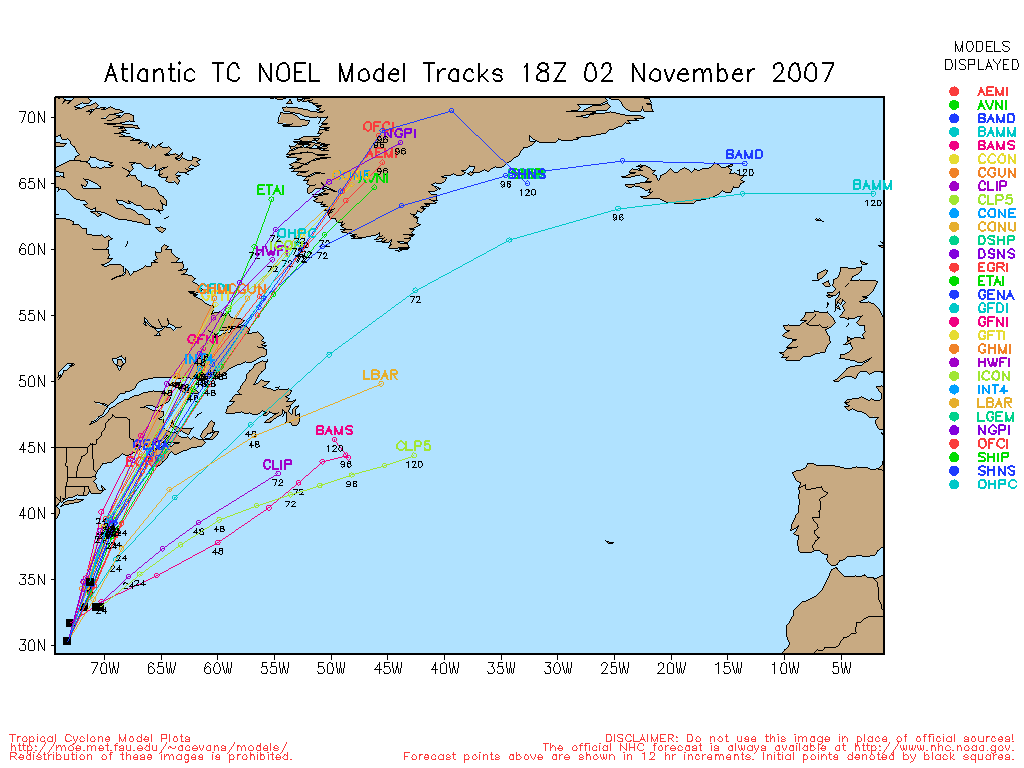
Some of the most divergent model runs are popping up at 29/00Z. To consider any of these with any more faith than with a grain of salt we still need to be able to have a center fix that we can truly believe, and that is looking mighty challenging tonight.
Here are a few notables from the 00Z runs which highlight the discrepancies still very much underway:
GFDL: Crosses Noel over DR/Haiti and then eases left (westward). Straightens out. Reorganizes Noel a bit. Noel becomes a Cat 1-2 crossing the Bahamas and begins easing a bit right, approaching Bermuda as a major hurricane. Continues on as a Cat 2/3 before undergoing ET. Threatens Nova Scotia as a very potent hybridizing cyclone, asymmetrically warm-cored.
UKMET: Takes TS Noel through western DR/Haiti and drives him wnw along and/or just offshore of Cuba through the rest of the week!
GFS: Loses the closed LLC of Noel over DR/Haiti. Devolves the remains into a trof. Reforms a new LLC northwest of there, and takes it northwest towards offshore southeast Florida & the Bahamas. Loses this LLC, and devolves it into another trof. Forms yet another LLC north-northeast of that location, up near Bermuda. Scrapes Bermuda from the east with a new or newly reborn TS Noel (??) and then just about stalls it out to drift in that location.
NAM: Loses the closed LLC of Noel over DR/Haiti. Redevelops it well to the southwest of there, and drives the newly reborn TS Noel (??) northwest through the Yucatan Channel and/or over extreme western Cuba for Halloween.
Trick or Treat!
It's enough to make you want to eat some candy in the middle of the night.
|
cieldumort
Moderator
Reged: Mon
Posts: 2305
Loc: Austin, Tx
|
|
Let's see what we can determine from a good deal of daylight, but most certainly at least what was "Noel" (pronounced Knoll in case anyone is still wondering) is over the Dominican Republic & Haiti at this hour... and based on a rather exhaustive flight by recon overnight, it looks like a center reformed under the convective burst, and drew back down surface pressures to about 1002mb (down from 1004) prior to landfall.
However, giving a tip of the hat to Dem's observation above, as well as the and 00Z runs, it appears that there could be a situation where, oddly enough, the new LLC/old MLC go on to do something.. or much of nothing.. or perhaps a lot of something.. off to the north/northwest of DR/Haiti this week .. while, meanwhile back at the Rancho Caribbean, the old LLC drifts.. perhaps as per NAM, to get its act together and head west-northwest towards the Yucatan Channel.
A fortuitous pass just came in from the AMSRE, Advanced Microwave Scanning Radiometer (AMSR-E), on board NASA's Earth Observation System (EOS) Aqua satellite: from an ob at 0647Z that really suggests to me that this may indeed be the case. Look closely, and you may conclude this yourself from the image provided through this link.
Still, I'll be more convinced of anything after several hours of daylight and more microwave passes. It's probably prudent to say that all areas from the western Caribbean to Florida to Cuba to the Bahamas to Bermuda still need to be alert this upcoming week.
|
allan
Weather Master
Reged: Thu
Posts: 468
Loc: Palm Coast, Florida
|
|
This mornings quickscat actually shows a weak circulation near 16N and 75W (no joke), near Jamaica.. perhaps the idea is not far behind as Ceildmont mentioned earlier...
Here you can deffinatly make out that weak tight circulation
http://manati.orbit.nesdis.noaa.gov/dataimages21/cur/zooms/WMBas20.png
It's also where the anticycloe is and some convection has been swirling around it.. I think we need to watch this one possibly for Olga or a big time reformation jump to Noel.
You can deffinatly make out the convection swirl near Jamaica to.. this is what the quickscat is showing the "closed circulation". You can not go wrong with quickscat, this is gonna be an interesting day
http://www.ssd.noaa.gov/goes/flt/t1/sloop-rb.html
--------------------
Allan Reed - 18,9,5
Edited by allan (Mon Oct 29 2007 09:43 AM)
|


 Threaded


