John C
Unregistered
|
|
Update - Saturday 07/12 11:30AM ET
Tropical Storm Warning is now in effect for the island of Bermuda.
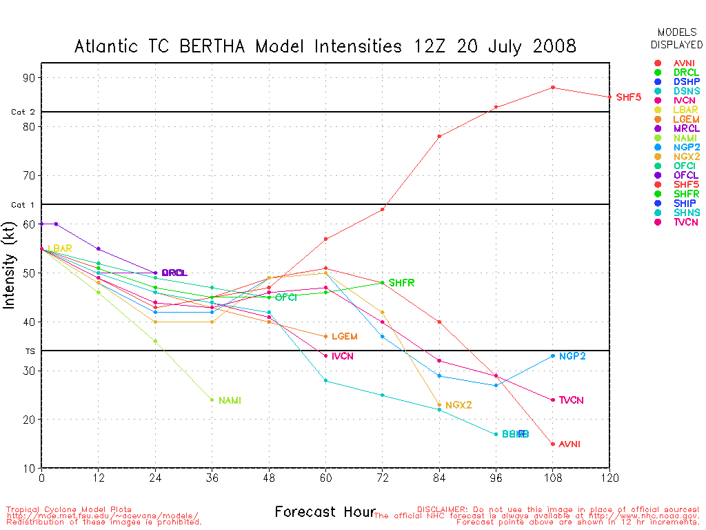
Bertha is a ragged looking tropical cyclone. Like much of yesterday, Bertha is composed of a massive eye and outer band of moderate convection, with a remnant inner eye and occasional attempts at eye-wall rattling around inside. Her movement has been virtually stationary over the last 6 hours. numbers have eased by 5kts and her intensity is being officiated at 75kts. The stationary nature of Bertha may mean that SSTs are beginning to cool due to upwelling, and if so this would also begin to contribute to weakening.
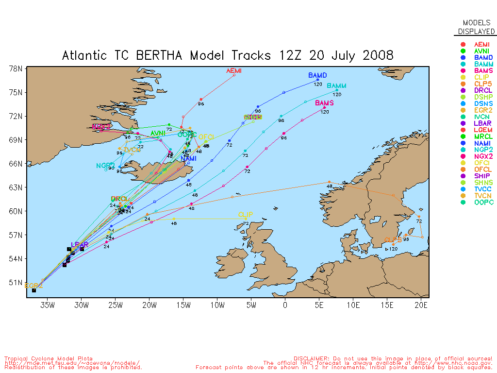
The forecast essentially is unchanged. There seems to somewhat better agreement among the models that she will stagnate for another 2 days, but then slowly...ever so slowly begin to move north and eventually northeast or east.
John (typhoon_tip)
Update - Friday 07/11 7:00PM ET
Tropical Storm watch remains in effect for the island of Bermuda.
Bertha continues to go through structural changes in her core. As of 5pm, the new advisory has set Bertha's winds at 80kts. Since then, the inner eye-wall appears to be trying to close off again. Light shear and still amply warm waters could mean some intensification should that be the case. The rest (below) unchanged from the 4:30pm update...

All available guidance combined indicates that Bertha will likely become a west Atlantic meandering menace to shipping, and perhaps a threat to Bermuda. It is still unclear exactly what that threat will be and how long it will persist. Steering field remains weak and is only providing for a slow northwest motion over the last 24 hours, and this looks to continue right through day 3. Beyond that, there is divergence in the guidance, ranging from slow northeast motion...to turning back south in response to a stronger ridge. Intensity is forecast by to very slowly decay over the 5 days. However, most of the 12Z guidance I've evaluated suggest only modest weakening, and some depictions, such as the , actually show a stronger system, days 4 and 5. It is extremely tedious to attempt to seek out minute factors that may or may not effect track and intensity, which is also susceptible to perturbation and emergence, therefore unknown at this time, to begin with. The over synoptic scheme, however, flexes the ridge north of Bertha in about 3 days, and this is really the impetus for showing the very slow, erratic, and even south motions day 4-6. Either is plausible at this time. In the nearer term, obviously interest in Bermuda need to monitor the progress of this storm.
Lastly, a growing consensus among the Global models is that a new CV tropical cyclone will get going between 60 and 72 hours, and do a similar act to Bertha in racing across the Atlantic at ludicrous speeds. This remains to be seen, but there is a TW nearby southeast of the CV islands.
John (typhoon_tip)
Update - Thursday 07/09 7:00PM ET
Bertha went through some interesting structural changes during this afternoon. The cyclone now has concentric eye-walls, the outer most being 75 nautical miles in diameter, while the inner is 10 miles in diameter. As is usually the case, when this outer eye-wall was established it robbed some of the inflow into the inner eye-wall, causing it to weaken. For these reasons and a recession it the numbers, Bertha's wind speed has been reduced to 75kts (~85mph). Just in the last 1 hour of IR imagery, however, the inner eye-wall appears to have strengthened, as a solid ring of cold cloud tops has just exploded and wrapped around. Overall, shear remains low and water temperature ample to sustain further strengthening. However, this is obviously predicated on Bertha's own structural morphologies not getting in the way of things. Probably fluctuations in intensity is the best way to go for now.
The forecast philosophy has also changed some. In the short term, a continued northwest to north drift is likely, in response a low amplitude trough currently moving by north of Bertha's location. There after the picture has become complicated. The last 24 hours of modeling have shifted the thinking away from the 2nd trough (day 4-5) being able to pick up Bertha and accelerate her finally to the graveyard. As far as I can tell there are no global model depictions during the day today that successfully pull Bertha north of middle latitudes, right through day 5. The National Hurricane Center confirms this thinking. Instead, the consensus has now shifted toward Bertha getting trapped amid a re-strengthened ridge axis nearby SE-E-NE of Bermuda, to rattle around for days. That said, it appears we will be tracking Bertha for quite some time.
There may be other areas of interest over the next week, as well. Both the ECM and have been pegging another potential TC genesis of CV origin approaching the Windward Islands...just as an early heads up.
John (typhoon_tip)
Update - Thursday 07/09 12:30PM ET
The only substantial change to note about hurricane Bertha this mid day is that the cloud tops have warmed slightly in the region, and the eye has become less impressive. This has lead to numbers that have settled back to 77kts. The TPC has officiated the winds to be 80kts (just over 90mph), but also suspect this to be generous. It is unclear what is causing this recent weakening trend (what's new in intensity guidance) as outflow remains fairly good, shear is low, and water temperatures are amply warm. The best that I, personally, can surmise is that there is dry air in the vicinity, and it may be that Bertha has been occasionally ingesting this stable air. The following is the WV image provided by NOAA:

Nevertheless, since the majority of parameters are in good shape it is more likely that Bertha will at least fluctuate in intensity over the next 3 days.
There is currently a trough pressing into the northwest Atlantic. As this passes the longitudes of Bertha, it will continue to create and impetus to move her north, albeit at slow rates of speed. In about 3 days, however, this trough will have left the longitudes of Bertha and a ridge will attempt to regain control north of Bermuda, prior to the next trough scheduled to arrive around day 4 or 5. The evolution of these events should ultimately force Bertha toward the graveyard. However, interests in Bermuda need to monitor this because as the latter ridge temporarily restrengthens in about 3 days, steering currents may drop off and/or even cause Bertha to turn left again. That may bring the TC quite close to the island of Bermuda.
John (typhoon_tip)
Update - Thursday 07/09 12:30AM ET
As of the 11pm advisory, Bertha remains on a general 310 degree motion, but it has been noted that during that for about 2 hours, a discerned due west motion transpired. That has, however, corrected back toward the same apparent 310 degree motion as of 12AM. These kinds of wobbles are quite common in TCs moving at slow rates of speed, and are most likely due to permutations in the convective behavior more than anything else. Her numbers were as high as 100kts but according to the TPC, they have recently come back to the 90kts (~105mph), making Bertha a category 2 hurricane.
Her presentation on satellite is intriguing as of the midnight hour. Her southwest quadrant is composed almost entirely of eye-wall, with limited outer features:

And, as you can see, her eye is still very well defined.
The forecast philosophy for Bertha has changed a little. Some of the more reliable models, including the and the , are conflicting with the , UKMET and about the position of Bertha after 72 hours. The former want to stall Bertha out just east or southeast of Bermuda, while the latter want to use an earlier trough to accelerate her toward the graveyard. Considering that the ridge north of Bertha has proven more resilient overall this warm season, a compromise is in order and the official call is for a near stall between 72 and 120 hours, while she awaits - perhaps - a more significant trough incursion from off the east coast, later on nearing day 5. Bertha could be moving rather erratically during that interval of time, and given to its relative close proximity to Bermuda, interest should pay close attention to the evolution of this system.
John (typhoon_tip)
Update - Wednesday 07/09 12:30PM ET
The 11am advisory still has a 300-degree motion associated with Bertha. Her current intensity is set at 65kts, and some improvement in satellite presentation during the morning suggests at least modest re-intensification is taking place.
There has been some conjecture as to whether or not Bertha has found the means to resume more westerly track motion. I am not seeing a big enough deviation between her apparent axis of circulation to that of the clear NW track motion provided by the TPC - they seem to be aligning just fine. Moreover, there are no compelling synoptic reasons that assert Bertha should be resuming a west motion, for the time being. It is likely that convective idiosyncrasies and cloud patterns resulting have given some visual effects of west motion. However, the longer period observation still shows a general NW motion has persisted throughout the course of these "wobbles".
Steering field remains weak, but with a trough "denting" the Bermuda ridge as it presses off-shore the NE U.S. over the next day and half, if anything this offers at least a small argument for continue northwest or perhaps even eventually a north motion...albeit slowly. Speed of motion does not appear to have any means to really accelerate until perhaps very late in the 5-day forecast period, at which time a stronger trough pushing off the Mid Atlantic and northeast coasts may very well finally accelerate Bertha seaward.
Until that time, Bermuda can not be ruled out as being impacted and should continue to monitor the progress of Bertha. And, it may be that 4 or 5 days of monitoring will be required.
John (typhoon_tip)
Update - Tuesday 07/08 10:30AM ET
Bertha is undergoing a great deal of shear and is weakening.
The eye itself remains barely intact beneath sheared clouds, but even that will not last long. Today it will likely gradually weaken more and later it may "decouple" from the system and then weaken more rapidly. Shear and Dry Air are taking its toll on Bertha this morning cloud tops are warming and other indications of weakening are all there.
What happened yesterday, and again this morning shows just how poorly intensity forecasting is understood. The lack of Recon because of the distance offshore and general lack of other data also had a lot to do with it.
The future track may slow down and con the track with speed and potential drifting later may force Bermuda to watch it for a while, although the forecast and models suggest it probably will pass well to the East of the island. It has a slight chance to have minor restrengthening after it gets through the first round of shear, but water temperatures in that area suggest it won't get close to the levels it had overnight. The official forecast just shows the system weakening.
The storm remains no threat to the United States. Bermuda will need to watch it for a bit longer.
Update - Monday 07/07 5PM ET
Bertha is now a Major Hurricane with sustained winds of 100 knots (115mph) and a central pressure of 948MB. Movement over the past six hours has been to the northwest at about 10 knots and a slower forward motion is likely as the storm has reached a weakness in the Atlantic Ridge. Bertha is probably close to (if not at) her peak intensity as upper level wind shear begins to influence her strength and a slow decline in wind speed is likely over the next few days. The folks in Bermuda still need to maintain a careful watch on this hurricane as the weekend approaches.

Elsewhere, the basin is quiet - for the moment - with another tropical wave likely to exit the west African coast on Tuesday.
ED
11:20 AM EDT 7-July-2008 Update
Bertha is now nearly a Category 2 hurricane, it will likely strengthen to be at or around a Category 2 hurricane today and part of tomorrow. After that it could enter a higher shear region and weaken, there are some signs it may fight that, however, and stay fairly strong.
The National Hurricane Center keeps it weakening, albiet slowly over the next several days. The current forecast track takes it East of Bermdua, but Bermuda itself is well within the cone. Interests in Bermuda should keep watch on this system.
The pressure as issued at 975mb, corrected from the first 11AM Advisory.
The still hasn't "found" the system and a lot of the track models take that into account, once it gets it we see a better handle on the shear and track.
Original Update
Bertha has become the atlantic basin 2008's first hurricane, and is still racing along fairly quickly at 17mph toward the west-northwest. It formed on July 7th, the same day that 1996's Bertha formed into a hurricane.
Bertha, as forecast, has become a hurricane with wind speeds of 75 MPH and the forward movement slowing down to 17 MPH.

In the past twelve hours, Bertha has started to turn more toward the west-northwest. Currently, it appears that Bertha is not a threat to the US mainland nor the Caribbean, but this is not completely solid yet so its still worth watching. The most likely scenario, by far, remains that it stays on the track and curves north.The newest trend suggests that Bermuda may feel the effects of Bertha this weekend. This according to the current National Hurricane Center forecast. Conditions probably will keep Bertha from gaining too much strength (right now it's looking pretty healthy), and it does not appear Bertha will gain much more than a Category 1 or 2 hurricane, in fact it is more likely that Bertha will weaken in the longer term.

Outside of Bertha, nothing appears to be forming over the next few days.
Event Related Links
Bermuda Newspapers/Media:
BerNews
Royal Gazette (Bermuda)
Bermuda Sun
Hott 107.5 Bermuda Radio
Storm Carib Bermuda Reports
Bermuda Weather Service
Bertha Event Related Links


SFWMD Model Plot (Animated Model Plot) SFWMD Hurricane Page
[https://flhurricane.com/floatanimator.php?year=2008&storm=2 Flhurricane Satellite Floater Animation of Bertha
GOES Floater
Animated Model Plot of Bertha
Clark Evans Track Model Plot of Bertha
(Animated!) Model Plots in Google Earth - In Google Maps
Clark Evans Intensity Model Plot of Bertha (Animated!)
Clark Evans Track Plot of Bertha
Other Model Charts from Clark
Clark Evans Top 10 Analog Storms for Bertha
More model runs on from RAL/Jonathan Vigh's page
NRL Info on Bertha -- RAMMB Info
COD Atlantic Satellite View
Edited by typhoon_tip (Sat Jul 12 2008 11:16 AM)
|
cieldumort
Moderator

Reged: Mon
Posts: 2305
Loc: Austin, Tx
|
|
Bertha is fast closing in on T numbers upwards of 5.5 this morning, particularly now that the agencies tasked with utilizing are doing so based on far more accurate center fixes. now gives ≥ 10% odds of Bertha becoming a major cane during any of Days 2 through 4, and this looks very hard to argue with, if not even conservative. While convection is still not very deep, ever warmer and warmer SSTs are in her future this week. So long as shear does not become a problem, the surrounding dry air should not have much luck impinging on her development. OTOH, should shear do some damage, especially given the dry air and SAL that abounds in the region, we could see a fast unwinding of this current phase.
As for track, seems a bit unsure of their own forecast. To be sure, there is some doubt about whether or not the progged trof will be significant enough to pull Bertha into a full recurve, should the trof really show up, in the first place.
|
craigm
Storm Tracker

Reged: Wed
Posts: 327
Loc: Palm City, Florida
|
|
Wow what are the odds another Bertha forming in july exactly on 7/7.
Looks like the tropical suite and the are breaking from the pack for now, but still showing recurve around 70w. Bertha's future is not written in stone yet as evidenced by this excerpt from the 5:00 AM discussion
'GIVEN THE WEAK
STEERING CURRENTS AND LACK OF A HIGH-AMPLITUDE TROUGH OVER THE
WESTERN ATLANTIC DURING THE NEXT SEVERAL DAYS...IT IS STILL NOT
GUARANTEED THAT BERTHA WILL RECURVE.'
Model experience however tells me to put my money on ,ukmet and .
--------------------
Why I'm here:
Weather hobbyist
|
MikeC
Admin
Reged: Sun
Posts: 4543
Loc: Orlando, FL
|
|
Bertha looks really healthy right now and has a good shot at becoming a Category 2 storm maybe even a little more, The shear that likely may tear it apart later right now is actually helping to evacuate some of the upper air right now helping the system to stay together.
I doubt that the trend will continue too much longer though.
|
scottsvb
Weather Master
Reged: Mon
Posts: 1184
Loc: fl
|
|
Agreed with Mike. I'm impressed with such a system at this point in July..especially where its at in the Atlantic. The did the best job so far on this system along with the . It's too early to tell if Bertha will come close to Bermuda or not but we do have time as she will slow down some in forward speed to the NW.
Edited by scottsvb (Mon Jul 07 2008 10:30 AM)
|
Fr33z3y
Unregistered
|
|
Wow Im watching the news atm&they just said it got bumped to a category two now.. ehh Well Im in FL& closely watching this storm
|
MikeC
Admin
Reged: Sun
Posts: 4543
Loc: Orlando, FL
|
|
Quote:
Wow Im watching the news atm&they just said it got bumped to a category two now.. ehh Well Im in FL& closely watching this storm
It's still a Category 1 (75-94mph) storm, but it very well could be a 2 later today.
|
chase 22
Weather Hobbyist

Reged: Fri
Posts: 82
Loc: San Angelo, TX
|
|
What is amazing is how fast Bertha is picking up strength given 24 hours ago, we were looking at a moderate tropical storm and now she's an almost cat 2 hurricane. It will be very interesting to see how much this trough (if any) will play a role with Bertha
--------------------
Matt
|
allan
Weather Master

Reged: Thu
Posts: 468
Loc: Palm Coast, Florida
|
|
It's been amazing but shear is 20-30 knots to the north which should keep Bertha at category 1 or even a minimal 2 range. Once Bertha moves north of the islands, shear will weaken and Bertha might surprise us. As of now, unless shear dramatically weakens to the northwest, without an anticyclone anymore, Bertha should remain under major hurricane intensity! The latest has two weaker troughs and just stalls Bertha while it slowly drifts northwest. I'd like to see the next few runs of this and other models. Bermuda is most likely to get hit with this but it would not surprise me that it reaches the USA coastline if the troughs are this weak. The first trough was already forecasted to be weak and lift Bertha north but now the is showing the second trough that was supposed to recurve Bertha as a weak front that stalls after crossing the northeast. Interesting stuff. When I say latest , it's the 12Z run that is still running.
http://www.nco.ncep.noaa.gov/pmb/nwprod/analysis/carib/gfs/12/model_l.shtml
I've been and still am looking for a recurvature west of Bermuda but east of the Carolinas. It's still a wait and see situation.
--------------------
Allan Reed - 18,9,5
Edited by allan (Mon Jul 07 2008 12:42 PM)
|
typhoon_tip
Meteorologist
Reged: Wed
Posts: 576
|
|
Quote:
What is amazing is how fast Bertha is picking up strength given 24 hours ago, we were looking at a moderate tropical storm and now she's an almost cat 2 hurricane. It will be very interesting to see how much this trough (if any) will play a role with Bertha
My own records show that TCs tend to go above official guidance expectation more than 50% of the time. If pegs a system at 70kts in 3 days for example...the system tends to be a tad stronger by that 3rd day. Virtually every storm in the mega 2005 historic season wound up being more intense than forecast intervals.
But in the case with Bertha, we have to remember that she passed over an interval of 25C SST, which took about 24 hours to do so. This probably stunted her growth. About this time yesterday morning, she began encroaching on 26C-30C type SSTs, and since the deep layer shear profiles have been favorable for strengthening all along, a speedy upswing was plausible.
Edited by typhoon_tip (Mon Jul 07 2008 01:06 PM)
|
scottsvb
Weather Master
Reged: Mon
Posts: 1184
Loc: fl
|
|
Allan thats a easy bet on between the Carolinas and Bermuda...right now.. thats the path or it may slide east of Bermuda .. but thats also a easy guess. Yeah the troughs are weak and faster to move in and out this time of year but I do feel Bermuda will be the closest landmass. I dont see this getting any closer than 68W if it misses the first trough.
At least this system takes the boring part of early July out of the way in the Atlantic...maybe we can get something else to watch later this weekend approaching the carribean! 
|
allan
Weather Master
Reged: Thu
Posts: 468
Loc: Palm Coast, Florida
|
|
Exactly, to much troughiness for Bertha to actually make it to the east coast. Bermudas gonna have to hunker down as they say, Berthas intensification is surprising to me, especially when shear is a bit high to the north. Shear goes all the way to 50 knots if it were to head straight north, yet shear lowers to 20 knots if it heads the forecasted direction. It was a tough forecast, wunderground bloggers were getting mixed up, now it seems like the path is finally starting to clear out. If the trough doesn't recurve it, next one should recurve it. Things should get interesting later in the month.
Edited by Ed Dunham (Mon Jul 07 2008 02:01 PM)
|
Rich B
British Meteorologist
Reged: Sat
Posts: 498
Loc: Gloucestershire, England, UK
|
|
The gift of modern satellite imagery! The latest visible loops show that Bertha continue to move west-northwest, and continue to become berrer organised. The eye has become clearer, and the outflow more evident immediatley atop the eyewall. Expect to see her at at least 100mph on the next advisory package. Bermuda is the only area in the next few days that really needs to pay close attention to Bertha, dependent on just how much affect the troughs have on direction, and the shear on strength!
--------------------
Rich B
SkyWarn UK
|
ftlaudbob
Storm Chaser

Reged: Tue
Posts: 828
Loc: Valladolid,Mx
|
|
Quote:
The gift of modern satellite imagery! The latest visible loops show that Bertha continue to move west-northwest, and continue to become berrer organised. The eye has become clearer, and the outflow more evident immediatley atop the eyewall. Expect to see her at at least 100mph on the next advisory package. Bermuda is the only area in the next few days that really needs to pay close attention to Bertha, dependent on just how much affect the troughs have on direction, and the shear on strength!
Yea she sure is looking very good as of now.I would not be surprised if she were a cat 3 on the 5pm update.A CV hurricane in the first week of July maybe a bad sign for the rest of the season.Good luck to all that are on Bermuda.
--------------------
Survived: 10 hurricanes in Rhode Island,Florida and the Yucatan of Mexico .
|
Rich B
British Meteorologist
Reged: Sat
Posts: 498
Loc: Gloucestershire, England, UK
|
|
NRL now have her at 970mb and 90knots - will be interesting to see if put her at 100 or 105 mph. Either way, looks like Bertha is on her way to Major Cane status.
--------------------
Rich B
SkyWarn UK
|
typhoon_tip
Meteorologist
Reged: Wed
Posts: 576
|
|
Quote:
NRL now have her at 970mb and 90knots - will be interesting to see if put her at 100 or 105 mph. Either way, looks like Bertha is on her way to Major Cane status.
I was watching this this afternoon and it looks intense to me as well. The last 2 hours in particular have wrapped her into some impressive symmetry.
She also appears to me to be already moving NW... The last 5 hours of looping is tough to argue against. I have a thread going over in the forecast lounge that discusses some things that could (and would need to) happen in order to keep this moving west. Clearly, those things are not taking place.
The recent ECM runs have been signaling a quasi -PNA pattern evolution for the U.S., and the thinking was that such a resulting Ohio Valley/Tennessee Valley ridge axis would probably merge with the persistent west/central Atlantic ridge. That would have pinned Bertha underneath, regardless of what the models had 3 days ago. However, Bertha moved too quickly across the Basin. I don't argue that there is a weakness in the geopotential medium and that there is some steering level response; just look at Bertha's motion.. However, her moving across the Atlantic Basin at near ludicrous speeds appears pretty clearly now to outrun these larger scale changes.
|
cieldumort
Moderator
Reged: Mon
Posts: 2305
Loc: Austin, Tx
|
|
Indeed , Bertha is doing very well for herself. ADT is now coming in at 115 knots, raw, as well as 3 hour averaged.
Much has been written here about Bertha's so-called surprisingly rapid intensification. However, this should be considered within the context of of not having had the advantage of recon in and out of there. As early as late yesterday afternoon there were clear indications that Bertha may had already become a hurricane, but owing to the lack of quality center fixes, not to mention the lack of any actual recon flight data at all, intensity estimates were not well-pegged to her actual center, and this often tends to give a negative bias to the final T, which, if left uncorrected, then also gets fed into the models, many of which have been way off on her actual intensity, and a bit off on location.
The fact that the CIMSS ADT product is now hitting regular, averaged T numbers of 6.0 or better owes a great deal to the clear eye offering an accurate place to start. Bertha may very well already be a major hurricane, and may have been one for a few hours. Bertha may have been a hurricane for almost 24 hours. Reanalysis will be very key to the record books, for this one.
|
Hugh
Senior Storm Chaser
Reged: Fri
Posts: 1060
Loc: Okaloosa County, Florida
|
|
Bertha's rapid intensification in defiance of the official forecast didn't surprise me, because I saw it coming via the satellite presentation. The impact of the shear on the intensity forecast appears to have been significantly overstated in the models and the official forecast. Motion, however, seems to be on track based upon the forecast, which just goes to show that the has a good handle on where hurricanes are going to go in the short term, but still is a long way from being able to forecast intensity. From here on out, I don't expect Bertha has peaked quite yet, and with T-numbers continuing to climb, it would not surprise me to see Bertha with 140+mph winds by morning, before leveling off due to EWRCs.
--------------------
Hugh
Eloise (1975) - Elena and several other near misses (1985) - Erin & Opal (1995) - Ivan (2004)
|
M.A.
Weather Guru
Reged: Thu
Posts: 108
Loc: Vero Beach, Fl
|
|
I am very impressed with the intensification of Bertha over the last 24hrs ( Bingo Bango). I have been a naysayer on this storm since day one. I've been wrong before and will be wrong again, maybe even in this post.lol I do believe that Bertha has peaked in intensity. The shear on the northern portion is starting to have an effect on the overall . I do believe that the last few frames on the sat loop show a slot of dry air being drawn in from the northeast, and the over all is warming significantly inturn.
|
LoisCane
Veteran Storm Chaser

Reged: Fri
Posts: 1236
Loc: South Florida
|
|
Her eye is contracting down to a pin point, she's may hit Cat 4 before dawn. Apologies on this one, Ciel was right on the Category 3 today. Shows again and again how a hurricane can hit Major Cane status without the best of conditions in an only optimal environment.. once they get the engine going they can really spin up fast. Also, her center has been small the whole time and it is easier for a small storm to ramp up like this than a bigger one.
Amazing. Would say she can easily barrel through a high but you never know until you know so keep watching.
Inner eye going to go through Eye Wall Replacement Cycles sooner rather than later. And, she is barely moving it seems.
http://www.ssd.noaa.gov/goes/flt/t1/jsl-l.jpg
--------------------
http://hurricaneharbor.blogspot.com/
|
|


 Threaded


