MikeC
Admin
Reged: Sun
Posts: 4543
Loc: Orlando, FL
|
|
3:00PM EDT / 2:00 CDT 23 July 2008 Update
Dolly has made landfall at South Padre Island.
9:33AM EDT / 8:33 CDT 23 July 2008 Update
From recon reports, it appears that Dolly is now a Category 2 Hurricane.
7:45AM EDT / 6:45 CDT 23 July 2008 Update
Dolly is nearing Category 2 strength as it heads generally toward the Rio Grande river.
Pressure has fallen off this morning, and Dolly is looking better organized than last night.
Dolly's forward motion is slower this morning, and it still appears to be slowing down, which could cause rainfall totals over Southern Texas/Northern Mexico to be extreme (10 inches in some spots, possibly more). This area has had a bit of a drought lately,so some rain is welcome, these however, will likely cause flooding.
Hopefully everyone has prepared. It may be a lot of those that stayed at or near the coast will say "I'll never stay there during a hurricane again" very soon.

Good luck and God bless all those in the path of the system.
Original Update
Dolly has been upgraded to Hurricane Status, during the evening hours conditions will deteriorate in Southern Texas and northern Mexico. Hurricane Warnings are up from Rio San Fernando in Mexico across the border to Corpus Christi.
Dolly is also slowing down forward motion, which could prolong the period of heavy rainfall and winds over the area.

Dolly's internal structure has improved this afternoon. Recent IR and hi resolution visible satellite imagery strongly argue for the production of an eye. We are also see the explosive genesis of a central dense overcast (CDO) feature. This combined with recent reconnaissance report of 75kt flight level wind has prompted National Hurricane Center to upgrade Dolly to hurricane status.
As of the 5pm EDT update, her forward motion has been decreasing slightly and is now northwest at 10mph. Central pressure was approximately 986mb and her maximum winds were set at 75mph.
Oceanic heat content remains is good, shear has relaxed considerable over what Dolly experienced with the yesterday, and upper level divergence is looking good with clear anticyclonic outflow established. There is just ever so slightly some impinging southerly winds do to the s final last tentacles of contact, but it appears these are too weak at this point to be much of any significant mitigation to development. It is for these reasons that the official intensity by is set a little higher than the more robust model solutions, now taking Dolly to 80kts just prior to making landfall. It should be noted however, that a couple of higher resolution models (discussed below) are a tad slower and farther north along the coast. The longer Dolly stays over the warm waters of the Gulf, the stronger is could become.

There was some contention during the afternoon on where/when Dolly will cross the coastline. Earlier runs had somewhat tightly clustered around an approximate Brownsville landing. However, a couple of the higher resolution models, including the WRF and the HWRF, are bringing Dolly up farther along the TX Coast before turning her left and onto land. For this reason, folks up into the Bend area of the TX Coast need to monitor this with due diligence. This is also a good time to remind people not to focus on the exact location the actual eye crosses the coast, and to pay close attention to the wind field radii information.
This is also going to be a slow mover as it comes inland. Citizens in the interior parts of southern TX and near the Rio Grande valley need to take early precautionary measure to protect against the threat of flooding, in typically vulnerable areas, for what is likely to be a protracted period of excessive rainfall while Dolly slowly winds down.
John (typhoon_tip)
Event Related Links
Power Outage map for Brownsville Area
Brownsville, TX Radar Radar Loop
(Latest Static)
Corpus Christi, TX Radar Radar Loop
(Latest Static)
Texas/South Plains Radar Composite
Southeast Radar Composite (loop)
South Padre Island Blog
Local Media:
Brownsville Herald
The Monitor
Valley Morning Star
KGBT 4 News
KRGV Newschannel 5
KURV 710 News/Talk
Webcams:
Coastal Surfing Pier Cam (Corpus Christi)
South Padre Island Cams: BeachCam SurfCam Bay Cam
Rio Grande Cam in Mission, TX
Matamoros/Brownsvillle Cams
Recordings:
Dolly Brownsville Level 3 Radar
South Padre Beach Cam
South Padre Island Surf Cam -- High Res
South Padre Island Bay Cam (Down)
South Padre Island Radisson Resort Beach Cam
Bob Hall Pier Corpus Christi
Dolly Event Related Links


SFWMD Model Plot (Animated Model Plot) SFWMD Hurricane Page
[https://flhurricane.com/floatanimator.php?year=2008&storm=4 Flhurricane Satellite Floater Animation of Dolly
GOES Floater
Animated Model Plot of Dolly
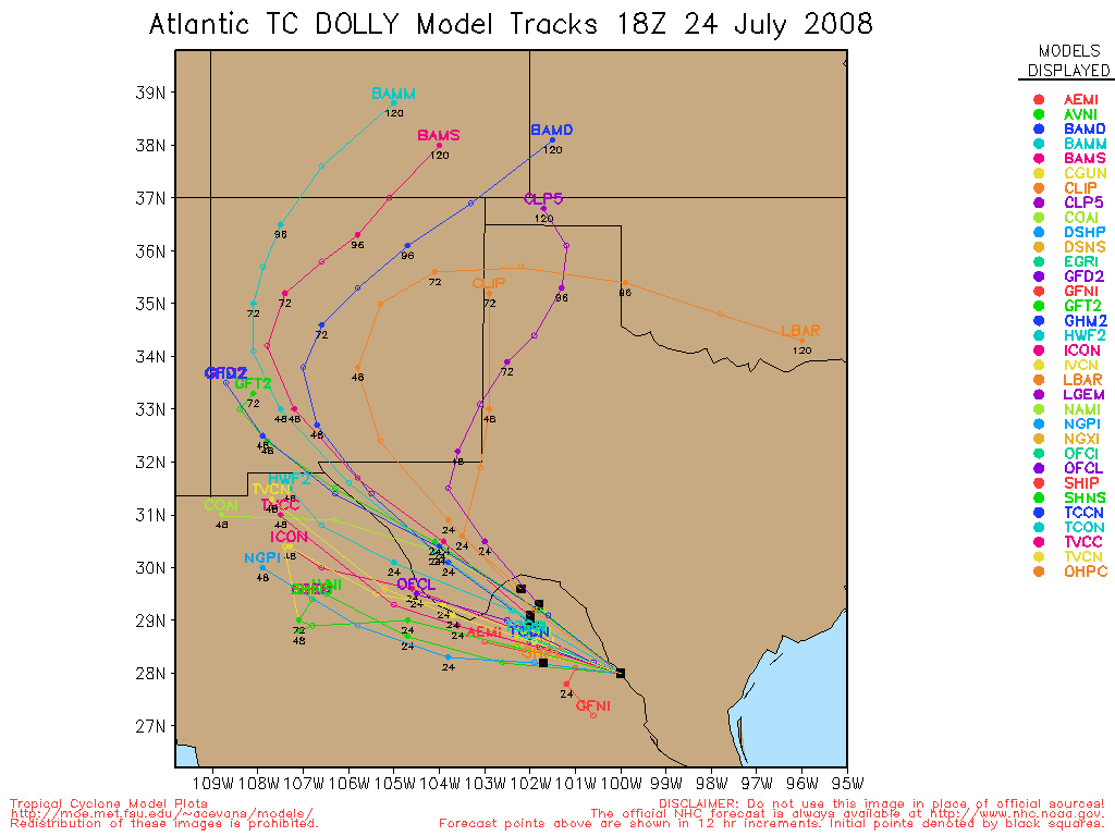
Clark Evans Track Model Plot of Dolly
(Animated!) Model Plots in Google Earth - In Google Maps
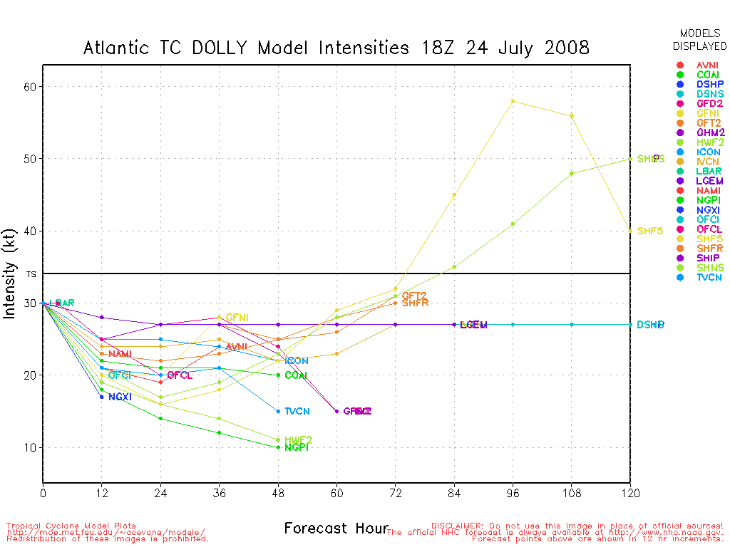
Clark Evans Intensity Model Plot of Dolly (Animated!)
Clark Evans Track Plot of Dolly
Other Model Charts from Clark
Clark Evans Top 10 Analog Storms for Dolly
More model runs on from RAL/Jonathan Vigh's page
NRL Info on Dolly -- RAMMB Info
COD Atlantic Satellite View
Cristobal Event Related Links


SFWMD Model Plot (Animated Model Plot) SFWMD Hurricane Page
[https://flhurricane.com/floatanimator.php?year=2008&storm=3 Flhurricane Satellite Floater Animation of Cristobal
GOES Floater
Animated Model Plot of Cristobal
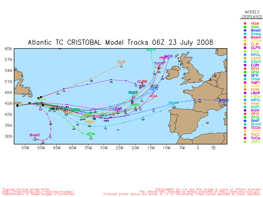
Clark Evans Track Model Plot of Cristobal
(Animated!) Model Plots in Google Earth - In Google Maps
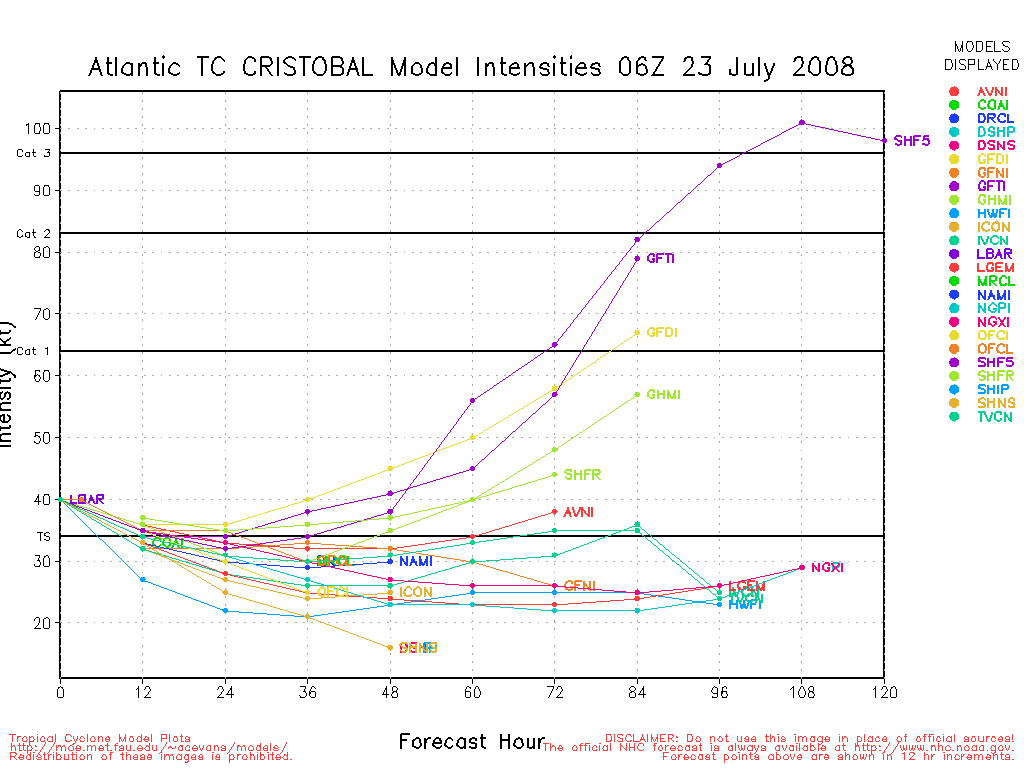
Clark Evans Intensity Model Plot of Cristobal (Animated!)
Clark Evans Track Plot of Cristobal
Other Model Charts from Clark
Clark Evans Top 10 Analog Storms for Cristobal
More model runs on from RAL/Jonathan Vigh's page
NRL Info on Cristobal -- RAMMB Info
COD Atlantic Satellite View
97L Event Related Links


SFWMD Model Plot (Animated Model Plot) SFWMD Hurricane Page
[https://flhurricane.com/floatanimator.php?year=2008&storm=5 Flhurricane Satellite Floater Animation of 97L
GOES Floater
Animated Model Plot of 97L
Clark Evans Track Model Plot of 97L
(Animated!) Model Plots in Google Earth - In Google Maps
Clark Evans Intensity Model Plot of 97L (Animated!)
Clark Evans Track Plot of 97L
Other Model Charts from Clark
Clark Evans Top 10 Analog Storms for 97L
More model runs on from RAL/Jonathan Vigh's page
NRL Info on 97L -- RAMMB Info
COD Atlantic Satellite View
|
Storm Hunter
Veteran Storm Chaser

Reged: Wed
Posts: 1370
Loc: Panama City Beach, Fl.
|
|
here's the flight path from AF Recon who is still on the storm... notice the classic flight pattern. The three eye passes have different pressure readings everytime... indications that Dolly is getting stronger. N42RF is south of PNS flying wsw from Tampa.
UPDATE: AFRECON is about 20miles from center coming in from the NW... will see what Dolly is up too in a 15 mins or so..
there in the eyewall a few mins ago... NW side...
Time:
21:52:30Z
Coordinates:
24.92N 95.62W
Acft. Static Air Press:
695.8 mb (~ 20.55 inHg)
Acft. Geopotential Hgt:
3,034 meters (~ 9,954 feet)
Extrap. SFC. Press:
990.2 mb (~ 29.24 inHg)
D-value:
-
Flt. Lvl. Wind (30s):
From 52° at 49 knots (From the NE at ~ 56.3 mph)
Air Temp:
9.0°C (~ 48.2°F)
Dew Pt:
9.0°C (~ 48.2°F)
Peak (10s) Flt. Lvl. Wind:
52 knots (~ 59.8 mph)
SFMR Peak (10s) SFC. Wind:
65 knots (~ 74.8 mph)
SFMR Rain Rate:
33 mm/hr (~ 1.30 in/hr)
(*) Denotes suspect data
--------------------
www.Stormhunter7.com ***see my flight into Hurricane Ike ***
Wx Data: KFLPANAM23 / CW8771
2012== 23/10/9/5 sys/strms/hurr/majh
Edited by Storm Hunter (Tue Jul 22 2008 06:04 PM)
|
Storm Hunter
Veteran Storm Chaser
Reged: Wed
Posts: 1370
Loc: Panama City Beach, Fl.
|
|
looks like pressure down to 984mb... dropsonde data just hit the servers... vortex report coming soon
984mb (29.06 inHg) at the surface... air temp 27.0°C (80.6°F) dew point 25.6°C (78.1°F)
--------------------
www.Stormhunter7.com ***see my flight into Hurricane Ike ***
Wx Data: KFLPANAM23 / CW8771
2012== 23/10/9/5 sys/strms/hurr/majh
Edited by Storm Hunter (Tue Jul 22 2008 06:24 PM)
|
Storm Hunter
Veteran Storm Chaser
Reged: Wed
Posts: 1370
Loc: Panama City Beach, Fl.
|
|
Vortex report out
pressure down
Product: Air Force Vortex Message (URNT12 KNHC)
Transmitted: 22nd day of the month at 22:21Z
Aircraft: Air Force Aircraft (Last 3 digits of the tail number are 307)
Storm Number & Year: 04L in 2008
Storm Name: Dolly (in the North Atlantic basin)
Mission Number: 16
Observation Number: 16
A. Time of Center Fix: 22nd day of the month at 22:00:10Z
B. Center Fix Coordinates: 24°44'N 95°24'W (24.73N 95.40W)
B. Center Fix Location: 155 miles (249 km) between the ESE and SE (123°) from Brownsville, TX, USA.
C. Minimum Height at Standard Level: 2,967m (9,734ft) at 700mb
D. Estimated (by SFMR or visually) Maximum Surface Wind: 66kts (~ 76.0mph)
E. Location of the Estimated Maximum Surface Wind: 20 nautical miles (23 statute miles) to the NW (311°) of center fix
F. Maximum Flight Level Wind Inbound: From 48° at 62kts (From the NE at ~ 71.3mph)
G. Location of Maximum Flight Level Wind Inbound: 33 nautical miles (38 statute miles) to the NW (311°) of center fix
H. Minimum Sea Level Pressure: 984mb (29.06 inHg)
I. Maximum Flight Level Temp & Pressure Altitude Outside Eye: 10°C (50°F) at a pressure alt. of 3,035m (9,957ft)
J. Maximum Flight Level Temp & Pressure Altitude Inside Eye: 13°C (55°F) at a pressure alt. of 3,053m (10,016ft)
...............................................
Remarks Section:
Maximum Flight Level Wind: 72kts (~ 82.9mph) in the northeast quadrant at 20:29:30Z
Distance of Surface Center From Flight Center: Surface center is within 5 nautical miles of flight center.
--------------------
www.Stormhunter7.com ***see my flight into Hurricane Ike ***
Wx Data: KFLPANAM23 / CW8771
2012== 23/10/9/5 sys/strms/hurr/majh
|
Storm Hunter
Veteran Storm Chaser
Reged: Wed
Posts: 1370
Loc: Panama City Beach, Fl.
|
|
latest vortex from AF Recon.. continues to show a 1mb per hr drop.. down to 982mb.. one thing i have noticed in the recon mission... the temperature at flight level at 10,000ft. is changing with time... almost a 10 deg. difference now between inside and outside the center/eyewall... at 10kft. NOAA plane made a pass through at about the same time the AF recon plane did a 180 and appears to be headed home. GPS dropsonde from NOAA plane recorded a Sea Surface Temperature: 28.0°C in the western eyewall
--------------------
www.Stormhunter7.com ***see my flight into Hurricane Ike ***
Wx Data: KFLPANAM23 / CW8771
2012== 23/10/9/5 sys/strms/hurr/majh
|
LoisCane
Veteran Storm Chaser

Reged: Fri
Posts: 1236
Loc: South Florida
|
|
Thanks for the recon data. Amazing that she finally has an eye. Models did a good job holding on to her throughout her slow progress into a hurricane.
Concerned about the sat imagery that shows so much rainfall on her north side. Imagine many places along the
Texas coastline will get huge amounts of rain from this storm and since she is slow moving there could be many problems along a widespread area.
Hope people within her various warning areas take note of fast changing weather conditions.
Love the cam with the radar on the main page.
--------------------
http://hurricaneharbor.blogspot.com/
|
cieldumort
Moderator

Reged: Mon
Posts: 2305
Loc: Austin, Tx
|
|
Fresh water flooding is likely to be the greatest threat of all out of Dolly.. and this will apply to her sphere of influence all the way around, and not just on any one side.
To her left and inland (likely will be to her southwest at landfall and then south as she progresses inland) are the formidable Sierra Madre Orientals. Dolly could easily wring out 10-30++ inches of rain over large areas in these, considering her slowing forward speed, and ultimately, her expected demise over these very mountains
In the Rio Grande Valley, Dolly is expected to produce widespread 3 to 8 inch rainfall totals, with locally higher amounts of 15 inches or more.. largely dependent on her forward speed, assuming she makes landfall within about 40 miles either side of Brownsville. On Abrams & Bettes tonight (TWC) Mike Bettes was reporting from lines of cars and trucks blocks long.. people waiting in them for up to two and a half hours for their maximum allotment of eight sand bags.
Of course, as with all landfalling tropical cyclones, tornadoes and waterspouts will probably become a risk, and Texas tends to get them good from TCs. SPC has been hinting around that watches will be going up for much of extreme south Texas - along the coast initially, and then progressing inland. (As Random points out, they were in fact issuing Watch #732 as I was typing - It covers deep south Texas and adjacent coastal waters until 10AM Wednesday - A very long duration, but also an ever-slower moving hurricane).
All-in-all, those 80MPH winds are in a really small portion of the cyclone. Considering how small a sliver within the eyewall the HF winds are, Brownsville may never experience them at all. Of course, for whoever does, it's going to feel like an EF1 tornado that just goes on and on and on. Prudent course of action is to not play by un-boarded windows.
Edited by cieldumort (Wed Jul 23 2008 12:17 AM)
|
Random Chaos
Weather Analyst

Reged: Sat
Posts: 1024
Loc: Maryland
|
|
Correction: already a tornado watch up for Southern Texas:
http://www.spc.noaa.gov/products/watch/ww0732.html
|
scottsvb
Weather Master
Reged: Mon
Posts: 1184
Loc: fl
|
|
Dolly doesnt have a eye,.,...just a center of circulation....A " EYE" is apparent when all radar and satellite imagery show little if any weather in the center of circulation.....Dolly has cold cloud tops over the center on infrared still.. this could change though in the early hours of the morning.
|
cieldumort
Moderator
Reged: Mon
Posts: 2305
Loc: Austin, Tx
|
|
Nighttime has been good to Dolly so far, but bad for south Texas.
As of 1AM CDT, Brownsville radar, color-enhanced IRs and the most recent microwave passes expose an undeniable improvement in Dolly's internal structure, including a now essentially complete, 360°, closed eyewall, although it is a bit ragged and still weak in parts. Cloud tops have also cooled substantially during the past few hours, with a ring of very cold tops now encircling the COC.
Given that numerous center fixes have found Dolly's pressure to have leveled off at around 982mb, with the recent developments it becomes reasonable to expect her winds to soon follow, with perhaps even yet another lowering of her pressure before sunrise. An oft-associated pressure-to-wind relationship suggests an increase to 85MPH, given the 982mb level, and another deepening phase may render this past-news before too long.
On a tracking side note, given the slowing of forward speed and a few obvious wobbles, it would be very prudent that everyone even fairly well north and south of the center of 's "Cone of Uncertainty" to rush to completion any preparations they need to make to be prepared for a significant hurricane strike.
|
Storm Hunter
Veteran Storm Chaser
Reged: Wed
Posts: 1370
Loc: Panama City Beach, Fl.
|
|
agree with your obs... i thought in recent views on sats... that a opening was appearing, maybe some weak sign of the eye... not sure about that just yet....i love the fact that the levell II data is in super res. mode and showing a very decent eyewall. (from KBRO) First TIME for everything... hehe. The biggest concern to me will be the FRESH WATER Flooding... i hope people take the warning and get to higher grounds... cuz with the expected rain... that area will flood for a few days.... before it flushes back into the GOM.
Recon about to make what looks like last pass through the center. and based on some data coming in.. i think the pressure is starting to drop again.. will know in a few mins
UPDATE: pressure is back to falling again... down to 980mb EYE is open on the south side... and until she cloeses the south side of the eye, she shouldn't get to much stronger.
A. Time of Center Fix: 23rd day of the month at 6:14:30Z
B. Center Fix Coordinates: 25°27'N 96°16'W (25.45N 96.27W)
B. Center Fix Location: 83 miles (133 km) to the ESE (114°) from Brownsville, TX, USA.
C. Minimum Height at Standard Level: 2,902m (9,521ft) at 700mb
D. Estimated (by SFMR or visually) Maximum Surface Wind: 55kts (~ 63.3mph)
E. Location of the Estimated Maximum Surface Wind: 22 nautical miles (25 statute miles) to the WNW (296°) of center fix
F. Maximum Flight Level Wind Inbound: From 20° at 60kts (From the NNE at ~ 69.0mph)
G. Location of Maximum Flight Level Wind Inbound: 11 nautical miles (13 statute miles) to the WNW (286°) of center fix
H. Minimum Sea Level Pressure: 980mb (28.94 inHg)
I. Maximum Flight Level Temp & Pressure Altitude Outside Eye: 10°C (50°F) at a pressure alt. of 3,049m (10,003ft)
J. Maximum Flight Level Temp & Pressure Altitude Inside Eye: 12°C (54°F) at a pressure alt. of 3,047m (9,997ft)
K. Dewpoint Temp (collected at same location as temp inside eye): 11°C (52°F)
K. Sea Surface Temp (collected at same location as temp inside eye): Not Available
L. Eye Character: Open in the south
M. Eye Shape & Diameter: Circular with a diameter of 22 nautical miles (25 statute miles)
N. Fix Determined By: Penetration, Radar, Wind, Pressure and Temperature
N. Fix Level: 700mb
O. Navigation Fix Accuracy: 0.02 nautical miles
O. Meteorological Accuracy: 1 nautical mile
Remarks Section:
Maximum Flight Level Wind: 75kts (~ 86.3mph) in the northeast quadrant at 5:04:20Z
Maximum Flight Level Wind Outbound: 73kts (~ 84.0mph) in the southeast quadrant at 6:20:10Z
Maximum Surface (likely estimated by SFMR) Wind Outbound: 64kts (~ 73.6mph) in the southeast quadrant at 6:20:20Z
Edited by Storm Hunter (Wed Jul 23 2008 02:44 AM)
|
cieldumort
Moderator
Reged: Mon
Posts: 2305
Loc: Austin, Tx
|
|
It looks like we're about to get a new one below 975.. and still falling.
Surprising that winds aren't yet much higher than 80-ish. This almost has to change, shortly.
Close-enough.. Here's a bit of the 4AM Discussion
Quote:
NWS TPC/NATIONAL HURRICANE CENTER MIAMI FL AL042008
500 AM EDT WED JUL 23 2008
AIR FORCE HURRICANE HUNTER DROPSONDE OBSERVATIONS INDICATE THAT THE
CENTRAL PRESSURE HAS FALLEN TO 976 MB...A RATHER SIGNIFICANT
DECREASE OVER THE PAST COUPLE OF HOURS. ALTHOUGH THE SFMR...
DROPSONDE...AND FLIGHT-LEVEL WIND MEASUREMENTS UP TO NOW HAVE
YIELDED 70 KT FOR THE CURRENT INTENSITY...I HAVE TOO MUCH RESPECT
FOR THIS ABRUPT FALL IN PRESSURE TO NOT SHOW ANY INCREASE IN
STRENGTH. THEREFORE THE CURRENT INTENSITY IS ADJUSTED TO 75 KT FOR
THIS ADVISORY. WSR-88D DOPPLER RADAR FROM BROWNSVILLE SHOWS A
BANDING-TYPE EYE THAT IS TRYING TO CLOSE OFF ALONG WITH AN INCREASE
IN FEEDER BANDS OVER THE PAST SEVERAL HOURS.
Edited by cieldumort (Wed Jul 23 2008 04:51 AM)
|
xxflcyclonexx
Verified CFHC User
Reged: Wed
Posts: 24
Loc: Charlotte County
|
|
Dolly really does look as though she's getting her act together. Each time I look at the radar and sat images I'm more impressed. I think I see a little jog to the north as well. Could be a wobble though but Brownsville is looking more like ground zero than ever, to me at least.
On a sidenote, Cristobal, or what's left of it, is racing by Newfoundland. Here's the view from the St . John's radar http://www.weatheroffice.gc.ca/radar/index_e.html?id=WTP
|
Random Chaos
Weather Analyst
Reged: Sat
Posts: 1024
Loc: Maryland
|
|
Down to 972mb with a closed 20nm circular eye.
Surface winds to 79mph (69kts).
Per vortex recon half hour ago.
Edit:
Inbound dropsonde got 82kt surface winds (and 103kt not that far up). Wonder why they picked 69kt for the vortex recon?
We should have another vortex recon in the next 20 minutes.
Edited by Random Chaos (Wed Jul 23 2008 07:45 AM)
|
Kraig
Weather Hobbyist

Reged: Sun
Posts: 68
Loc: Jupiter, Fl
|
|
From the 5am Discussion......."SHOULD DOLLY MOVE MORE SLOWLY OVER EXTREME SOUTHERN TEXAS THAN WE ARE FORECASTING...IT IS POSSIBLE FOR IT TO PRODUCE EVEN MORE RAINFALL THAN WE ARE CURRENTLY PREDICTING."
From the Brownsville composite radar loop, it appears that Dolly has slowed even further, making little if any progress in the last hour.......similar to of SE Florida in 2004!
--------------------
2022 forecast 21/11/4; 0/0/0 as of 6/1
South FL Native: David ('79), Floyd ('87), Andrew ('92), Georges ('98), Irene ('99), Charlie, Frances & Jeanne ('04), Wilma ('05), Matthew ('16), Irma ('17), Dorian ('19) and Isaias (20)
|
Random Chaos
Weather Analyst
Reged: Sat
Posts: 1024
Loc: Maryland
|
|
Tornado Warnings up in Texas!
http://forecast.weather.gov/wwamap/wwatxtget.php?cwa=bro&wwa=tornado%20warning
|
MikeC
Admin
Reged: Sun
Posts: 4543
Loc: Orlando, FL
|
|
Not much more to do now other than wish the best for those in South Texas and Northern Mexico.
The camera recordings should all start back up at 8AM EDT (7AM CDT), assuming they still have power.
Other warnings (Tornado, flood, etc) will show up for Brownsville on the main page top popups,
Recordings:
Dolly Brownsville Level 3 Radar (Now Active)
South Padre Beach Cam
South Padre Island Surf Cam -- High Res
South Padre Island Bay Cam (Now Active)
South Padre Island Radisson Resort Beach Cam (Now Active)
Webcams:
Coastal Surfing Pier Cam (Corpus Christi)
South Padre Island Cams: BeachCam SurfCam Bay Cam
Rio Grande Cam in Mission, TX
Matamoros/Brownsvillle Cams
|
Random Chaos
Weather Analyst
Reged: Sat
Posts: 1024
Loc: Maryland
|
|
Eye pass complete.
HDOB estimates 966mb. Waiting on Dropsonde and Vortex Recon messages. Will update this post when they arrive.
Vortex Recon in:
Product: Air Force Vortex Message (URNT12 KNHC)
Transmitted: 23rd day of the month at 11:59Z
Aircraft: Air Force Aircraft (Last 3 digits of the tail number are 302)
Storm Number & Year: 04L in 2008
Storm Name: Dolly (in the North Atlantic basin)
Mission Number: 19
Observation Number: 11
A. Time of Center Fix: 23rd day of the month at 11:46:50Z
B. Center Fix Coordinates: 25°49'N 96°38'W (25.82N 96.63W)
B. Center Fix Location: 54 miles (86 km) to the E (98°) from Brownsville, TX, USA.
C. Minimum Height at Standard Level: 2,818m (9,245ft) at 700mb
D. Estimated (by SFMR or visually) Maximum Surface Wind: 59kts (~ 67.9mph)
E. Location of the Estimated Maximum Surface Wind: 14 nautical miles (16 statute miles) to the SE (132°) of center fix
F. Maximum Flight Level Wind Inbound: From 227° at 74kts (From the SW at ~ 85.2mph)
G. Location of Maximum Flight Level Wind Inbound: 11 nautical miles (13 statute miles) to the SE (131°) of center fix
H. Minimum Sea Level Pressure: 967mb (28.56 inHg)
I. Maximum Flight Level Temp & Pressure Altitude Outside Eye: 10°C (50°F) at a pressure alt. of 3,045m (9,990ft)
J. Maximum Flight Level Temp & Pressure Altitude Inside Eye: 15°C (59°F) at a pressure alt. of 3,041m (9,977ft)
K. Dewpoint Temp (collected at same location as temp inside eye): 9°C (48°F)
K. Sea Surface Temp (collected at same location as temp inside eye): Not Available
L. Eye Character: C20
M. Eye Shape / Orientation / Diameter (Undecoded): CLOSED
N. Fix Determined By: Penetration, Radar, Wind, Pressure and Temperature
N. Fix Level: 700mb
O. Navigation Fix Accuracy: 0.02 nautical miles
O. Meteorological Accuracy: 3 nautical miles
Remarks Section:
Maximum Flight Level Wind: 86kts (~ 99.0mph) in the northeast quadrant at 10:31:20Z
Maximum Flight Level Wind Outbound: 78kts (~ 89.8mph) in the northwest quadrant at 11:52:40Z
---
This represents a 5mb drop in about an hour. Pretty fast drop. We should start seeing the winds catch up with the pressure drops pretty soon.
Edited by Random Chaos (Wed Jul 23 2008 08:04 AM)
|
flanewscameraman
Weather Watcher
Reged: Fri
Posts: 33
Loc: Palm Beach County, FLA
|
|
I am in Mcallen Texas at the moment, and the weather is deteriorating slowly, clouds lowering and wind slowly picking up. I am curious if the track of the storm will bring the eye over Mcallen.
|
Ed in Va
Weather Master
Reged: Fri
Posts: 489
Loc:
|
|
Given the current track, I'd guess the eye will come over you. Keep in mind, however, that Dolly will start to lose strength as soon as she makes landfall. She will probably be a minimal hurricane or strong tropical storm by the time she gets to you. Be on the lookout for tornadoes.
--------------------
Survived Carol and Edna '54 in Maine. Guess this kind of dates me!
|


 Threaded


