MikeC
Admin
Reged: Sun
Posts: 4543
Loc: Orlando, FL
|
|
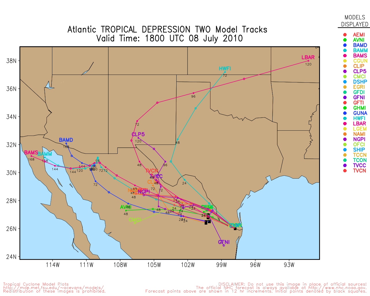
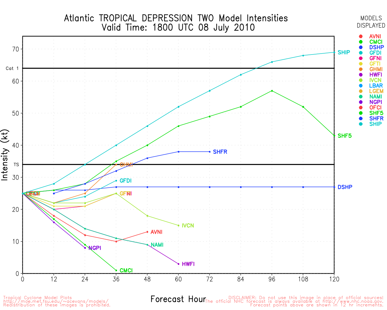
11PM EDT 7 July 2010 Update
The second Tropical Depression of 2010 forms, landfall in northern Mexico expected tomorrow evening.
Tropical Storm Warnings from Baffin Bay, TX southward to San Fernando in Mexico. Warnings were issued since there is a chance it could become a Tropical Storm tomorrow. If it were to be named, it would be called Bonnie. There is a fair chance it will not strengthen into a tropical storm also.
This will primarily be another rainfall event for South Texas as well, on top of what they got last week from Alex.
8:30PM EDT 7 July 2010 Update

Texas Gulf Coast Links
[http://moe.met.fsu.edu/~mnissenbaum/radar.html Mark Nissenbaum's radar page}
East to West:
Houston/Galveston, TX Radar Radar Loop
(Latest Static)
Corpus Christi, TX Radar Radar Loop
(Latest Static)
Brownsville, TX Radar Radar Loop
(Latest Static)
Gulf of Mexico Satellite Imagery
Area Forecast Discussions:
Houston/Galveston, TX
- Corpus Christi, TX - Browsnville/South Padre Island, TX
North Gulf Links
North Gulf/Southern Mississippi Valley Composite Radar Loop
(Latest Static)
East to West:
Mobile, AL Radar Radar Loop
(Latest Static)
New Orleans, LA Radar Radar Loop
(Latest Static)
Lake Charles, LA Radar Radar Loop
(Latest Static)
Houston/Galveston, TX Radar Radar Loop
(Latest Static)
Gulf of Mexico Satellite Imagery
Area Forecast Discussions:
Mississippi/Alabama/Pensacola -
New Orleans, LA -
Lake Charles, LA -
Houston/Galveston, TX
Cameron County Texas, Scanner Audio Feed (Police/Fire/EMT) -- Brownsville Area
Cameron County, TX Emergency Operations Center
Southeast Texas Power Outage Map
Weather Observations:
Corpus Christi, Texas
Kingsville NAS, Texas
Harlingen, Texas
Brownsville, Texas
Matamoros, Mexico
Ciudad Victoria, Mexico
Tampico, Mexico
Local Media:
Brownsville Herald
The Monitor
South Padre Island Breeze
Valley Morning Star
KGBT 4 News
KRGV Newschannel 5
KVEO News Channel 23
KURV 710 News/Talk Radio
StormCarib Reports from the Caribbean Islands
Caribbean Weather Observations
Barbados Brohav Weather Fax
Full Caribbean Radar Composite
Caribbean Broadcast Corporation (TV/Radio from Antilles)
San Juan, PR NWS Page
Various Caribbean Radio Stations
DR1 Dominican Republic Hurricanes
TD#2 Event Related Links


SFWMD Model Plot (Animated Model Plot) SFWMD Hurricane Page
[https://flhurricane.com/floatanimator.php?year=2010&storm=2 Flhurricane Satellite Floater Animation of TD#2
GOES Floater
Animated Model Plot of TD#2
Clark Evans Track Model Plot of TD#2
(Animated!) Model Plots in Google Earth - In Google Maps
Clark Evans Intensity Model Plot of TD#2 (Animated!)
Clark Evans Track Plot of TD#2
Other Model Charts from Clark
Clark Evans Top 10 Analog Storms for TD#2
More model runs on from RAL/Jonathan Vigh's page
NRL Info on TD#2 -- RAMMB Info
COD Atlantic Satellite View
3PM EDT 7 July 2010 Update
Chances for development have gone up since this morning, as the wave in the gulf (96L) looks better organized this afternoon. If it does develop it will likely be tomorrow, and the most likely landfall point is in northern Mexico. It is likely to remain weak, even if it becomes a depression.
7AM EDT 7 July 2010 Update
The wave being tracked over the last few days is now in the Gulf, and chances for development are (as of 2AM) 40%, but it appears most likely it will not develop, at least not today. Convection did not refire overnight and it is very ragged appearing on satellite imagery.

The recon flight scheduled for today is likely to be canceled.
Things in favor of development is that it now has a low level circulation, a bit large or broad, but it's there.
The most likely outcome from 96L is some more rain in areas that already had seen a lot from Alex. It's likely to come ashore around northern Mexico/South Texas, probably as a wave or depression, but nothing much more than that. Conditions in the tropics right now are relatively hostile for development in general.
The wave still should be watched in case any organization changes happen, but odds are against it. If it were to develop, Thursday afternoon/evening would be the most likely time.
Nothing else in the basin has a shot at development for the next few days, longer term there is a wave off Africa that may be worth watching to see if it persists, but it's still a bit too early to expect things out there.
7AM EDT 6 July 2010 Update
The low in the Gulf moved ashore last night and is bringing rainfall and some winds to a small area in Louisiana.
The wave in the west Caribbean (96L) has not really organized overnight, and there appears to be no closed low level circulation. So 30% is still about right for that. It's very likely that the recon flight scheduled for today will be canceled. It is still worth watching for later in the week, however.
Shear is really affecting this system, and it will struggle to get wrapped into a symmetrical circulation. That and the upper level low to the west and trough to the east will also keep overall development chances low. If it does develop, look toward the end of the week.
Still those in Mexico and Texas will want to watch this for any signs of development, especially once it is in the Gulf of Mexico.
Most likely it is a rainmaker for Texas and nothing more.

Cancun Radar Recording of 96L approach
The other areas being tracked have all fallen apart. The eastern Caribbean wave is near Puerto Rico now, and other than the ones mentioned there is a reprieve in Tropical Activity.
7PM EDT 5 July 2010 Update
The low in the gulf (95L) is approaching land and has suddenly spun up again, and has a 60% chance of potential to become a depression or Tropical storm before landfall. Currently no Tropical Storm Watches/Warnings are up. This small system did something similar yesterday, where it spun up relatively quickly and then went down again.
Radar from the area (
New Orleans, LA Radar Radar Loop
(Latest Static)
) is showing it still offshore.
Original Update
The National Hurricane Center's tropical weather outlook has 3 areas to watch.

The first area, 95L in the Gulf, is a very small low pressure area that, for a bit yesterday, spun up quite a bit. Even though in all likelihood nothing will ever develop out of the system, it still needs to be watched because it is so small and so close to land. It has the potential to spin up very quickly because of the small size, but more likely to spin out/down ever faster. Conditions around it favor no development.
The second area being tracked is the tropical wave (96L) in the Western Caribbean. It has the best chance,currently, of all the areas to develop, but looks to remain on the weaker side. Looking at satellite imagery this morning it is not looking that great. It is on the edge of a shear zone, and it has ok outflow, but it hasn't really persisted enough. It still has a fairly high chance of development, but just not today. If this one develops, it is most likely going to stay weak. It is bringing rainfall to the Caymans and the Yucatan.
With 96L being a weaker system it implies a more westerly move, but the overall patter is less so than it was for Alex. Recon was scheduled to go out to the system today, but it was canceled because of how poorly organized it looks this morning. They may try again tomorrow.
The final wave is in the east Caribbean which may be worth watching later in the week when it arrives in the western side, but until then it'll just be watched.
The area northeast of the Bahamas is now off the list.
|
WesnWylie
Weather Guru
Reged: Sat
Posts: 155
Loc:
|
|
Even though 96L has become more disorganized since last night,
I would not write it off just yet. Its circulation still appears to be intact,
and if it can get more storms to wrap around it, we may have a tropical
depression sometime tonight or tomorrow. Since the center of 96L
has shifted quite a bit north from its 06Z position, the model tracks
are now taking it in to Texas. My only real concern for its development
is the dry air it has taken in because it still appears that shear is not
much of an issue.
--------------------
2011 Season Forecast: 16/09/04
2011 Systems: 10/01/01
|
JMII
Weather Master

Reged: Thu
Posts: 489
Loc: Margate, Florida
|
|
95L has been dumping rain here in S (and central) FL for THREE days now. I was in central FL for the holiday weekend and it was a complete wash out. Nothing real heavy (some lighting) but constant, low, dark clouds and light to moderate rain for hours at a time.
--------------------
South FL Native... experienced many tropical systems, put up the panels for:
David 79 - Floyd 87 - Andrew 92 - Georges 98 - Frances 04 - Wilma 05 - Matthew 16 - Irma 17
Lost our St James City rental property to Ian 22
|
Lamar-Plant City
Storm Tracker

Reged: Mon
Posts: 383
Loc: Plant City, Florida
|
|
Quote:
95L has been dumping rain here in S (and central) FL for THREE days now. I was in central FL for the holiday weekend and it was a complete wash out. Nothing real heavy (some lighting) but constant, low, dark clouds and light to moderate rain for hours at a time.
Here in Tampa we haven't really seen the sun since Saturday and then only briefly. Very odd for this time of year. We keep getting impulses of light/moderate rain in off the GOM out of the southwest every 3-6 hours. Tampa radar showing a bit of spinning motion centered about 100 miles off shore although the way things are moving, it is likely nothing more than random cloud/rain movements. Could have gone home early from work today, but I figured, WHY?
--------------------
If you don't like the weather, wait 5 minutes...
2023 Season Prediction: 17/6/2
|
k___g
Weather Guru

Reged: Fri
Posts: 110
Loc: Leesburg, FL
|
|
Here in Orlando it has been overcast and rainy for most of the weekend. Has anyone noticed the uptick in activity over South Florida and the SE Gulf coast? Is this something to watch???
Edited by k___g (Mon Jul 05 2010 03:47 PM)
|
berrywr
Weather Analyst

Reged: Fri
Posts: 387
Loc: Opelika, AL
|
|
There is a diffuse stationary front that lies from St. Augustine WSW to the west coast of FL and an argument could be made there's nothing left of it. In the upper air is where things are complicated. There is an upper low and/or inverted upper trough draping the entire northern Gulf coast extending W and SW to another upper low off the Southern TX coast. Hot upper ridge over the NE USA and a deeper upper low off DELMARVA. Forcast has another upper long wave trough for the Eastern US broader and reaching the Deep South in 4 to 5 days.
Models have whatever may develop with a date with S TX but wind shear analysis has the western and central GOM and the W Caribbean open for business, despite an upper low off the S TX coast.
If a depression develops, the upcoming upper pattern will be very, very complicated.
--------------------
Sincerely,
Bill Berry
"Survived Trigonometry and Calculus I"
|
Ed Dunham
Former Meteorologist & CFHC Forum Moderator (Ed Passed Away on May 14, 2017)
Reged: Sun
Posts: 2565
Loc: Melbourne, FL
|
|
Invest 95L located at 28.7N 91W at 05/18Z. From at 2110Z:
" SMALL WELL-DEFINED LOW PRESSURE SYSTEM LOCATED ABOUT 50 MILES
SOUTH-SOUTHEAST OF MORGAN CITY LOUISIANA IS MOVING ONSHORE
TERREBONNE PARISH NEAR CAILLOU BAY. DOPPLER RADAR AND SATELLITE
DATA INDICATE THAT SUSTAINED WINDS NEAR TROPICAL-STORM-FORCE COULD
OCCUR ACROSS TERREBONNE PARISH...ESPECIALLY IN TERREBONNE
BAY...LATE THIS AFTERNOON AND EARLY EVENING AS THE SYSTEM MOVES
ONSHORE. THERE IS A HIGH CHANCE...60 PERCENT...OF THIS SYSTEM
BECOMING A TROPICAL CYCLONE BEFORE IT MOVES ONSHORE."
Heavy rainfall likely in portions of Louisiana this evening and Tuesday.
ED
|
cieldumort
Moderator

Reged: Mon
Posts: 2305
Loc: Austin, Tx
|
|
I keep thinking how 95L is one of those systems where different opinions may be found in some abundance. For example, my own take is that 95L has sufficiently qualified as a tropical cyclone for the past 36 hours or so. And if the on again off again nature of 's new color-coded system (down to "almost 0%" earlier this afternoon, then Shazam! now up to "60%" late this afternoon) is any indication, there may even be a bit of official disagreement as to how to handle this one in real-time.
I expect that many a postmortem of the system will confirm 95L to be a TD/perhaps weak TS - and it still remains to be seen if we get to see an official bump now. If not now, perhaps we will post-season.
Regardless of how 95L gets handled operationally, the fact is, it is just now starting to come ashore, and as noted by , is packing areas of near tropical storm force winds and some heavy rain, and save academia, this is what we really need to be focusing on right now, anyway.
So vacationers and residents directly in the path of 95L, particularly locations along its right front quadrant, should now be prepared for the likelihood of some imminent moderate to heavy rain, a chance of some pockets of tropical storm force winds - at least in the gusts, and a risk of some isolated waterspouts or tornadoes.
|
WesnWylie
Weather Guru
Reged: Sat
Posts: 155
Loc:
|
|
Well, the has dropped 95L back to near 0%
since they say it is moving inland. I think it did make
it to at least tropical depression status in my opinion.
|
Storm Hunter
Veteran Storm Chaser

Reged: Wed
Posts: 1370
Loc: Panama City Beach, Fl.
|
|
Just not sure about 96L... I attached a sat pic and placed where i think a surface coc would be. The movement would take it NW across land into the SGOM.
--------------------
www.Stormhunter7.com ***see my flight into Hurricane Ike ***
Wx Data: KFLPANAM23 / CW8771
2012== 23/10/9/5 sys/strms/hurr/majh
|
docrod
Weather Watcher

Reged: Tue
Posts: 36
Loc: Florida Keys, Key Colony Beach
|
|
Thanks Mike,
Being in the Fl Keys, I'm mostly watching the waves to my east. My friends in Texas still need to watch 96L which flared up this eve. I cut down >800 gallons of top heavy trees today and hope to keep up this weekly pace through the rest of this month.
Now is the time to check one's list and prepare. Hope everyone is getting ready.
- good eve - Rod
]
|
cieldumort
Moderator
Reged: Mon
Posts: 2305
Loc: Austin, Tx
|
|
Special Marine Warning continues for the waters off southern Louisiana for winds at or above 34 knots and waterpouts.

1100 PM CDT MON JUL 5 2010 ...A SPECIAL MARINE WARNING REMAINS IN EFFECT UNTIL 1130 PM CDT... FOR THE FOLLOWING AREA... WATERS FROM LOWER ATCHAFALAYA RIVER TO INTRACOASTAL CITY LA FROM 20 TO 60 NM OVER GULF OF MEXICO WATERS... AT 1054 PM CDT...NATIONAL WEATHER SERVICE DOPPLER RADAR CONTINUED TO INDICATE A LINE OF THUNDERSTORMS...CAPABLE OF PRODUCING WATERSPOUTS. AT 1031 PM CDT...NATIONAL WEATHER SERVICE DOPPLER RADAR CONTINUED TO INDICATE A LINE OF THUNDERSTORMS...PRODUCING STRONG WINDS 34 KNOTS OR GREATER FROM 9 NM NORTHEAST OF MARSH ISLAND TO 16 NM SOUTH OF MARSH ISLAND...MOVING WEST AT 10 KNOTS. THESE STRONG THUNDERSTORMS WILL BE NEAR VERMILION BAY BY 1130 PM CDT...
--------------------
Fully vaccinated as of May 2021
(Moderna x2)
|
WesnWylie
Weather Guru
Reged: Sat
Posts: 155
Loc:
|
|
Looking at the radar, I don't think that 95L has actually moved inland.
It appears as if it is moving north-northwest, so it is still moving along
the edge of the coastline. Cloud tops on 95L are still cooling. It definitely
is not dying out too soon tonight.
--------------------
2011 Season Forecast: 16/09/04
2011 Systems: 10/01/01
|
danielw
Moderator

Reged: Wed
Posts: 3525
Loc: Hattiesburg,MS (31.3N 89.3W)
|
|
Near perfect example of backing winds associated with a low moving through the area.
Last 6 hours of Lake Charles,LA airport observations.
Wind direction has backed from 060 to 340 in 6 hours.
KLCH 061131Z 34005KT 9SM BKN009 26/23 A2984 RMK AO2 $
KLCH 061053Z AUTO 34006KT 10SM BKN011 OVC033 26/23 A2983 RMK AO2 SLP107 T02610233 $
KLCH 061044Z AUTO 35005KT 10SM BKN013 26/23 A2982 RMK AO2 $
KLCH 061013Z AUTO 01009KT 10SM OVC015 26/23 A2982 RMK AO2 $
KLCH 061002Z AUTO 36005KT 10SM OVC013 26/23 A2983 RMK AO2 $
KLCH 060953Z AUTO 01007KT 10SM OVC015 26/23 A2983 RMK AO2 SLP108 T02610233 $
KLCH 060948Z AUTO 01006KT 10SM BKN013 OVC018 26/23 A2983 RMK AO2 $
KLCH 060853Z AUTO 02006KT 10SM BKN015 BKN021 OVC034 26/23 A2983 RMK AO2 SLP108 T02610233 56012 $
KLCH 060823Z AUTO 03006KT 10SM BKN017 OVC025 26/23 A2983 RMK AO2 $
KLCH 060815Z AUTO 03003KT 10SM SCT017 OVC025 26/23 A2983 RMK AO2 $
KLCH 060753Z AUTO 04005KT 10SM BKN017 26/23 A2983 RMK AO2 SLP110 T02560233 $
KLCH 060743Z AUTO 04004KT 10SM BKN017 BKN023 26/23 A2983 RMK AO2 $
KLCH 060732Z AUTO 02004KT 10SM SCT017 BKN023 26/23 A2984 RMK AO2 $
KLCH 060653Z AUTO 06004KT 10SM CLR 26/23 A2985 RMK AO2 SLP115 T02610233 $
Vortice center of 95L can be seen on the storm relative velocity product from Lake Charles,LA NWS radar.
Center is roughly where the dark green and the gold are closest together on the second circle from the center of the radar. See label.

Edited by danielw (Tue Jul 06 2010 08:22 AM)
|
MikeC
Admin
Reged: Sun
Posts: 4543
Loc: Orlando, FL
|
|
Added Cancun Radar Recording:
Cancun Radar Recording of 96L approach
|
WesnWylie
Weather Guru
Reged: Sat
Posts: 155
Loc:
|
|
96L seems to have a nice blow-up of convection this morning.
It will be interesting to see if it can sustain this convection
over land, or if it will fizzle before moving into the Gulf of Mexico.
I think it will probably move into the gulf later this afternoon or evening
(20z or so). 96L should move into a more favorable area for
development tonight and tomorrow. By more favorable, I mean
less shear. With that being said, I think this system has a 50/50
chance of developing in the next 24 hours.
|
hogrunr
Weather Guru

Reged: Sun
Posts: 153
Loc: Spring, TX
|
|
So is it just me or is there a completely separate broad low-level circulation along 25N 90W?
http://www.ssd.noaa.gov/goes/east/gmex/flash-rgb.html
http://cimss.ssec.wisc.edu/tropic2/real-...zoom=&time=
|
Storm Hunter
Veteran Storm Chaser
Reged: Wed
Posts: 1370
Loc: Panama City Beach, Fl.
|
|
Gonzo and Kermit are up doing a research mission around 96L. So expect tonights model runs to get a better handle on 96L. 42RF just took off at top of hour and 49RF is halfway through its mission!
--------------------
www.Stormhunter7.com ***see my flight into Hurricane Ike ***
Wx Data: KFLPANAM23 / CW8771
2012== 23/10/9/5 sys/strms/hurr/majh
|
WeatherNut
Weather Master
Reged: Wed
Posts: 412
Loc: Atlanta, GA
|
|
I see the one at 25N...but there is one more pronounced now over the Yucatan getting ready to enter the gulf
--------------------
Born into Cleo (64)...been stuck on em ever since
|
hogrunr
Weather Guru
Reged: Sun
Posts: 153
Loc: Spring, TX
|
|
Yes I agree, the one over the central gulf is very broad still, and as the day has gone by, the emergence of the circulation over the yucatan has definitely become the more defined feature. This thing needs to go away!! I want my beach vacation this weekend in Rockport! 
|


 Threaded


