MikeC
Admin
Reged: Sun
Posts: 4543
Loc: Orlando, FL
|
|
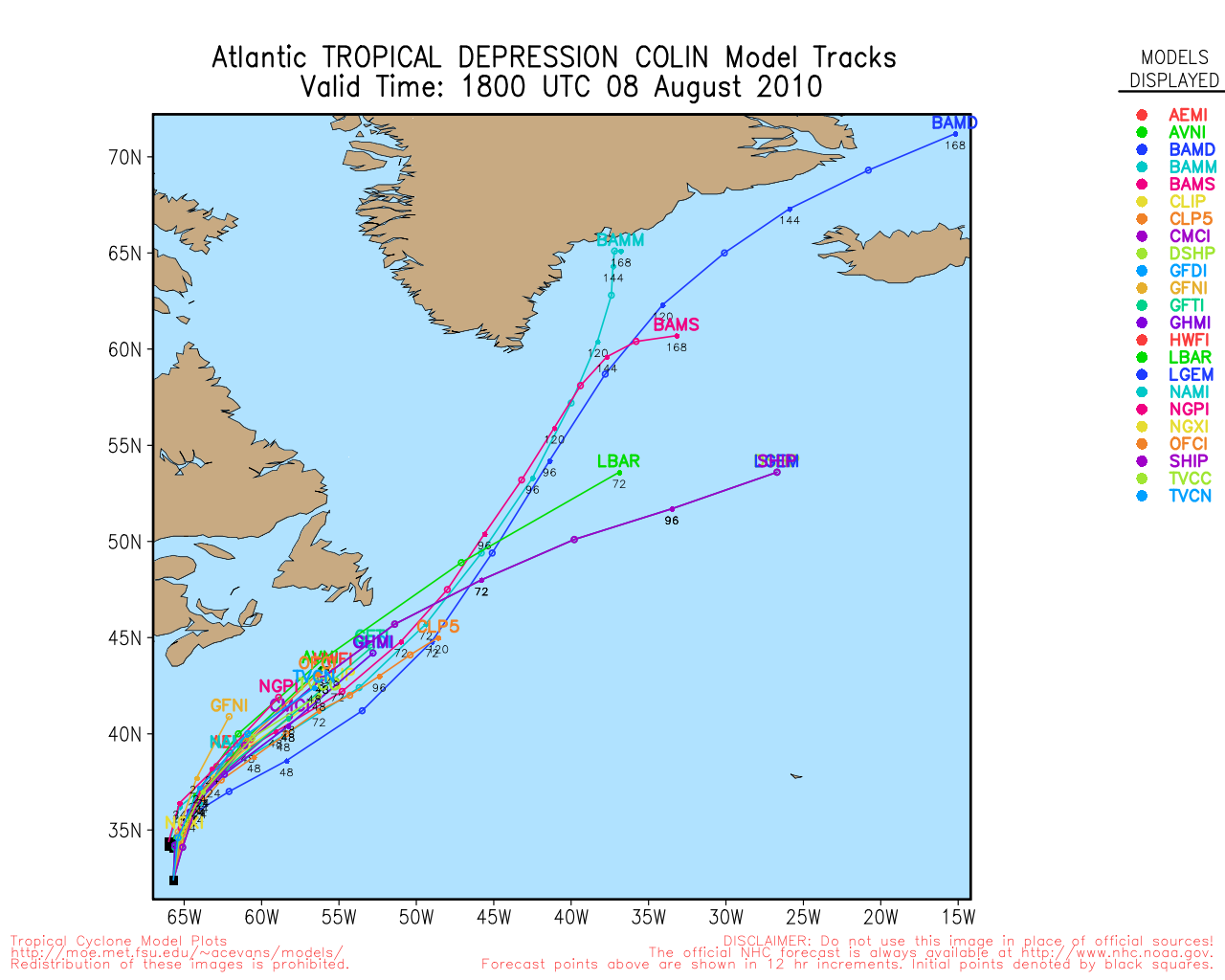
6 PM EDT Update, Aug 5, 2010
Tropical Storm Colin has regenerated after recon aircraft found tropical storm force winds and a circulation tonight.
Tropical Storm Warnings are up for Bermuda as the forecast track takes it just west of the island Saturday night.
It is forecast to stay under hurricane strength before transition in about 4 days.
The storm is not a direct threat to the US Mainland.
Colin Event Related Links


SFWMD Model Plot (Animated Model Plot) SFWMD Hurricane Page
[https://flhurricane.com/floatanimator.php?year=2010&storm=4 Flhurricane Satellite Floater Animation of Colin
GOES Floater
Animated Model Plot of Colin
Clark Evans Track Model Plot of Colin
(Animated!) Model Plots in Google Earth - In Google Maps
Clark Evans Intensity Model Plot of Colin (Animated!)
Clark Evans Track Plot of Colin
Other Model Charts from Clark
Clark Evans Top 10 Analog Storms for Colin
More model runs on from RAL/Jonathan Vigh's page
NRL Info on Colin -- RAMMB Info
COD Atlantic Satellite View
92L Event Related Links


SFWMD Model Plot (Animated Model Plot) SFWMD Hurricane Page
[https://flhurricane.com/floatanimator.php?year=2010&storm=5 Flhurricane Satellite Floater Animation of 92L
GOES Floater
Animated Model Plot of 92L
Clark Evans Track Model Plot of 92L
(Animated!) Model Plots in Google Earth - In Google Maps
Clark Evans Intensity Model Plot of 92L (Animated!)
Clark Evans Track Plot of 92L
Other Model Charts from Clark
Clark Evans Top 10 Analog Storms for 92L
More model runs on from RAL/Jonathan Vigh's page
NRL Info on 92L -- RAMMB Info
COD Atlantic Satellite View
93L Event Related Links


SFWMD Model Plot (Animated Model Plot) SFWMD Hurricane Page
[https://flhurricane.com/floatanimator.php?year=2010&storm=6 Flhurricane Satellite Floater Animation of 93L
GOES Floater
Animated Model Plot of 93L
Clark Evans Track Model Plot of 93L
(Animated!) Model Plots in Google Earth - In Google Maps
Clark Evans Intensity Model Plot of 93L (Animated!)
Clark Evans Track Plot of 93L
Other Model Charts from Clark
Clark Evans Top 10 Analog Storms for 93L
More model runs on from RAL/Jonathan Vigh's page
NRL Info on 93L -- RAMMB Info
COD Atlantic Satellite View
StormCarib Reports from the Caribbean Islands
Caribbean Weather Observations
Barbados Brohav Weather Fax
Full Caribbean Radar Composite
Caribbean Broadcast Corporation (TV/Radio from Antilles)
San Juan, PR NWS Page
Various Caribbean Radio Stations
DR1 Dominican Republic Hurricanes
7 AM EDT Update, Aug 5, 2010
The Tropical Atlantic continues the downturn which will probably last until the week of August 15th. In the meantime, though, the remnants of Colin seemed to organize some yesterday only to be somewhat squashed again today.
Colorado State's (Bill Gray and Phil Klotzbach) predictions were updated yesterday, and they are unchanged with 18 named storms, 10 hurricanes, and 5 majors. So far there have been 3 named storms and 1 hurricane, which leaves 15 more named storms, 9 more hurricanes, and 5 majors still to come according to them. There is still plenty to suggest the peak of the season will be active, and that is yet to come.
Regeneration of Colin may not occur, but if it were to it would be tonight at the earliest, with it being more likely toward the weekend. It's still currently at a 40% chance to regenerate. Odds still greatly favor it going out to sea regardless of development.
The wave in the Caribbean, on the other hand, fell apart overnight and chances for development will likely be dropping, and may never develop.
Another area in the Central Atlantic could be worth watching over the weekend or next week, but the overall set up for storms doesn't improve until at or just after mid August.
9 PM EDT Update, Aug 3, 2010
The wave in the Eastern Caribbean Sea has been designated Invest 92L.
This Area being highlighted is to the Southwest of Puerto Rico, and will have to be watched over the next few days.

6 PM EDT Update, Aug 3, 2010
Tropical Storm Colin became a Tropical Storm this morning, and after finding no evidence of a closed circulation from buoy reports this afternoon, the National Hurricane Center has issued the last advisory on Colin. But interestingly, forecasts it to Regain Tropical Depression status this weekend.
The center of Colin was ripped out by the influence of shear caused by a upper level (TUTT) low to the northwest of it, conditions don't begin to improve for it until Thursday/Friday or perhaps even in to the weekend. It will be tracked as a low pressure area, but will not have advisories unless it regains some strength.
The track still remains out to sea, because of the same area and weakness it has helped to generate. Those in the Carolinas will want to watch the area in case it regenerates, but odds are it won't have any direct affect.
The area in the East Caribbean is close to South America, which is preventing any development, and likely won't develop much at all, however the area closer to Puerto Rico may take over and if that does it may have to be watched. Outside of this, there isn't anything in the short term that could develop. Mid August is when most of the historical activity happens, and we'll be watching closely then for development.
6:15 AM EDT Update, Aug 3, 2010
Tropical Storm Colin has formed and odds are increasing that it will stay out to sea. Colin may be approaching some rather hostile conditions (shear along with a ) over the next few days, and will have little chance to strengthen beyond a Tropical Storm before getting there.
The Northeastern Caribbean, Bermuda and North Carolina will want to watch for changes in the track forecast, but odds are they will not be directly affected. Outside of that, there isn't much evidence to suggest further westward at this time. So those in other areas may want to watch it for any drastic changes in track, but that isn't likely.

The area in the Eastern Caribbean may form later in the week if it persists into the Western Caribbean, it currently isn't being tracked as an Invest.
StormCarib Reports from the Caribbean Islands
Caribbean Weather Observations
Barbados Brohav Weather Fax
Full Caribbean Radar Composite
Caribbean Broadcast Corporation (TV/Radio from Antilles)
San Juan, PR NWS Page
Various Caribbean Radio Stations
DR1 Dominican Republic Hurricanes
11AM EDT Update, Aug 2, 2010
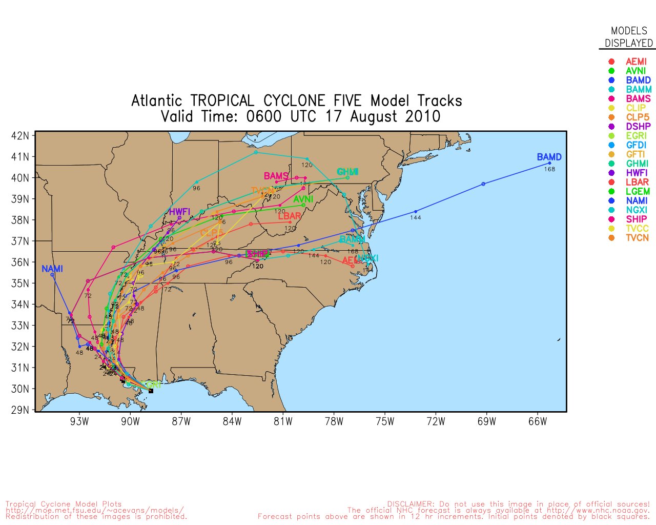
Invest 91L has been upgraded to the fourth Tropical Depression of the 2010 season. TD #4 is located well to the east of the Caribbean Islands moving to the west northwest at 17mph with maximum sustained winds of 35mph and a central pressure of 1006MB. Motion should continue to the west northwest with an eventual increase in forward speed. Additional intensification to Tropical Storm strength is likely. Although current track projections keep the system to the northeast of the Caribbean islands, residents of the northern islands should still closely monitor the development and progress of TD #4 over the next few days.
ED
7AM EDT Update 2 August 2010
The wave in the central Caribbean, marked as 91L, had a shot yesterday at becoming a depression, but a reliable indicator of a center of circulation could not be found. Today it may become a depression if that can be found.
Odds still slightly favor this system going out to sea, but much of it centers on if the system starts to move more northward or more westward.
If the system remains weak, or does not develop it will likely slip further west, shifting the forecasting model trends in general more toward the west as well. But until the system develops (or doesn't) using them to determine much other than comparing the short term trends to reality. Beyond that, what was written yesterday is pretty much the same.
If it starts moving more northerly, then out to sea becomes even more likely.
Those in the northeastern Caribbean will want to watch this very close, especially if the system slips further westward, and those in the Bahamas, Bermuda, Florida, and Southeast Coast up into the Carolinas may want to check back in a few days.

The is another wave, south and east of 91L that may be worth watching later as well.
Original Update
The wave in the Central Atlantic (redesignated 91L) now has a 60% chance for development in the next 48 hours, and if it does, tomorrow or Tuesday would be the best bet.
The odds are now that it will approach the northeastern Caribbean sometime later this week (most likely Wednesday/Thursday) and may just miss or clip it to the north, the system has a fairly slow forward motion right now.

It is still too far out to make a determination beyond that, but there's enough of a toss up (as far as remaining out to sea vs more westward) that it can't be ignored. If the system remains weaker, it may go further south into the Caribbean or over most of the islands and get torn up over Hispaniola. If it strengthens or forms earlier the more northerly situation is likely. Atmospheric conditions are very favorable for the latter.
What are the odds favoring now? Strengthening and the more northerly route. Although shear will increase as it gets closer to the islands which likely will keep it from being too strong until past the northeastern Caribbean.
Since the odds are more favorable for the northerly route, a key to the future track may be the presence of two upper ridges, one west of Bermuda and another over the southern plain states. If a weakness exists offshore the Carolinas, that would be what drags the wave more northerly, and if it barely misses the northeastern Caribbean, would be the cause. What's not happening there would likely be enough to continue to pull it out to sea. What happens after that is the weakness gets plugged, which completes the ridge and generally drags it more westward, which is why those in Florida would want to watch it. Chances for a gulf impact without Florida are low currently, but not non-existent. .
It will take until it develops and trends over the next few days to up the odds in any particular situation though. It is still very early, and nothing has developed yet. However it is August now, and historically this is the time to be very careful about systems such as these. All said and done, the odds still slightly favor it going out to sea.
Who will need to watch the system over the next week or so if it does develop? Northeastern Caribbean. Bahamas, Florida (particularly east central and south Florida), and the southeast Coast up to the Carolinas. The good news is that shear closer toward the Caribbean goes up, which will likely keep the system from getting too strong.
When? (Estimates can change if the forward motion of the system changes)
If it affects Northeast Caribbean?, for them Wednesday/Thursday
If it affects Bahamas? Saturday
If it affects Florida/East Coast? Sunday/Monday (next week)
|
typhoon_tip
Meteorologist
Reged: Wed
Posts: 576
|
|
I believe some re-analysis will prove that 91L is in fact the original after all, and the recently emerged TW from Africa confused the maelstrom and made it difficult to determine for approximately 36 hours, which entity was dominate. First we had a soon-to-be 90L with a -80C top region, and some sufficient enough banding to warrant "yellow" coding. Then, the wave comes off Africa and bullies it's way into the region, and seeds of 90L seemed to yield to that arrival... getting temporarily lost, such that when 90L finally got around to being assigned, it was done so further E - perhaps inappropriately associated with a proving to be non-genesis TW.
The reason I speculate that is because the convection associated with that follow-up wave appeared to wane actually, and then this new persistent convective region re-materialized further W with what originally sparked the yellow coding - I believe in a discrete sense that should be deemed the actual 90L in conserving entities, because that is what has really survived the interaction.
That said, the region is also kissed in general by an impressive monsoonal trough that is somewhat below normal surface pressure in that particular region ... acquiring cyclonic banding as we type. There does not appear to be any direct inhibitors to development; I thought easterly shear may have an impact but that does not seem to be evolving.
The longer term steering field appears to be fairly locked in the Global Numerical Models (GFS/GGEM...etc), and is understandable. There is a positive phase state in the North Atlantic Oscillation currently underway, and forecast to remain that way in the 21 member ensemble mean. What this teleconnection supports is stronger rather than weaker subtropical ridge presence over the next 5-7days, across the breadth of the N Atlantic. Barring any anomalies relative to, a generalized W to WNW track motion of "91L" (which may very well be a depression sometime over the next 2 days) right out through any meaningful time range of prediction (obviously beyond D4 we have to take even a tightly clustered modeled solution with a degree of incredulity) should be expected.
Still, populations in the NE Caribbean through the Puerto Rico archipelago and up through the Bahamas should monitor this over the next few days.
It should be noted that the 00Z solution offered an intense hurricane solution entering the SE Bahama archipelago in 6 days.
|
danielw
Moderator

Reged: Wed
Posts: 3525
Loc: Hattiesburg,MS (31.3N 89.3W)
|
|
I noticed the same fast moving Wave catching or phasing with the more western Wave. I'm not particularly impressed by the system other than it's persistant convection. The area appears on IR imagery to be 'riding the wave' on the SW edge of the SAL dust cloud. Similar to a reverse Bow Echo or the letter C.
Example- ,C (the comma is the system and C is the SAL)
NHC has bumped the formation possibility up to 60% as of 8 AM EDT this morning. But they are calling the system nearly stationary. ( Stationary usually means movement less than 7 mph in NWS terms )
|
danielw
Moderator
Reged: Wed
Posts: 3525
Loc: Hattiesburg,MS (31.3N 89.3W)
|
|
I'm not sure if this is the fast moving 2nd wave that caught up with 1st wave. Heavy rain and thunderstorms in Dakar for 5 hours.
Dakar, Senegal Africa weather observation during the worst of the weather last night. 16 hours ago.
METAR text: GOOY 010109Z 10012G25KT 3000 R36/1000VP1500 SQ TSRA BKN013 SCT030CB OVC120 24/23 Q1012 TEMPO 1000 +RA
Conditions at: GOOY (DAKAR/YOFF, SN) observed 0109 UTC 01 August 2010
Temperature: 24.0°C (75°F)
Dewpoint: 23.0°C (73°F) [RH = 94%]
Pressure (altimeter): 29.88 inches Hg (1012.0 mb)
Winds: from the E (100 degrees) at 14 MPH (12 knots; 6.2 m/s)
gusting to 29 MPH (25 knots; 13.0 m/s)
Visibility: 1.86 miles (2.99 km)
Ceiling: 1300 feet AGL
Clouds: broken clouds at 1300 feet AGL
scattered clouds at 3000 feet AGL
overcast cloud deck at 12000 feet AGL
Weather: TSRA SQ (rain associated with thunderstorm(s), squal)
Edited by danielw (Sun Aug 01 2010 12:40 PM)
|
WesnWylie
Weather Guru
Reged: Sat
Posts: 155
Loc:
|
|
In my opinion, I think 91L is looking pretty good right now. I can see a spin developing within the convection. I don't know if it is a mid or low-level, though. I think it will continue its movement toward the west-northwest for the next day or so, perhaps speeding up a bit. I have a feeling that the will hold the 60% chance for development or even bump it to 70% for the 1:00 p.m. CDT update.
--------------------
2011 Season Forecast: 16/09/04
2011 Systems: 10/01/01
|
Beaumont, TX
Storm Tracker
Reged: Tue
Posts: 318
|
|
91L is looking good right now and has upped the chance of development to 80%. I think we may be looking at advisories later in the day or tomorrow.
|
MikeC
Admin
Reged: Sun
Posts: 4543
Loc: Orlando, FL
|
|
They may be making the call based on microwave imagery, but convection seems to be on the decline at the moment, so it's really up in the air if they call it this afternoon, I still think it will be tomorrow before it becomes a depression, but if they do so early it won't matter all that much.
|
NewWatcher
Storm Tracker

Reged: Wed
Posts: 388
Loc: Port Orange, FL
|
|
Not much difference, but it does help when the declares it a TD because then we will have better modeling and soon, Recon, and ultimately a much better idea where on when on this invest.
--------------------
Pam in Volusia County
According to Colleen A ... "I AM A HURRICANE FREAK"
2007 Predictions 16/9/6
|
Hugh
Senior Storm Chaser
Reged: Fri
Posts: 1060
Loc: Okaloosa County, Florida
|
|
Quote:
They may be making the call based on microwave imagery, but convection seems to be on the decline at the moment, so it's really up in the air if they call it this afternoon, I still think it will be tomorrow before it becomes a depression, but if they do so early it won't matter all that much.
Look again. Convection is very impressive, and on the upswing. It's not clear to me if the convection is near the LLC, though. My guess is that the 8pm will leave it at 80%, but with the way the has been treating these things of late, it could go down to 60-70, or up to 90. I think they'll wait until sunrise to initiate advisories.
Update: 8pm is out... and... they went with 90%, saying "a tropical depression could form at any time".
--------------------
Hugh
Eloise (1975) - Elena and several other near misses (1985) - Erin & Opal (1995) - Ivan (2004)
Edited by Hugh (Sun Aug 01 2010 07:38 PM)
|
WesnWylie
Weather Guru
Reged: Sat
Posts: 155
Loc:
|
|
Looking at the satellite trends, I wonder if the center will be further east than previously thought. I do think the made a good call on raising the chance to 90% because 91L is doing really well right now. I was kind of worried that the SAL could get caught up within 91L, but it seems to be having no impact at this time.
--------------------
2011 Season Forecast: 16/09/04
2011 Systems: 10/01/01
|
docrod
Weather Watcher

Reged: Tue
Posts: 36
Loc: Florida Keys, Key Colony Beach
|
|
Quote:
Looking at the satellite trends, I wonder if the center will be further east than previously thought. I do think the made a good call on raising the chance to 90% because 91L is doing really well right now. I was kind of worried that the SAL could get caught up within 91L, but it seems to be having no impact at this time.
Saw that eastern swirl prior to sunset but there was a lot of convection to the west (later) as well. Time will tell. We should certainly have a name before Monday is out. The forecast track to the north of the leewards seems to be firming up. I'm all in favour of that but having been through the flooding of Georges in the Keys I will be ready.
|
srquirrely
Weather Watcher

Reged: Sat
Posts: 33
Loc: SARASOTA
|
|
It's o4 now. August off to a big start...
|
WeatherNut
Weather Master
Reged: Wed
Posts: 412
Loc: Atlanta, GA
|
|
Yes and I believe the next model runs are going to be to the left. The weakness they were forecasting is not materializing. The question now is how far TD4 stays from the area to its east. Too close and it robs energy from TD4. Also, how strong the system gets could matter. A strong system could split the trough ahead with one area going SW and the other pulling N. I have seen this before, and there is some indication on WVI that this could happen. A weak system probably wont make it. Welcome to August
--------------------
Born into Cleo (64)...been stuck on em ever since
|
danielw
Moderator
Reged: Wed
Posts: 3525
Loc: Hattiesburg,MS (31.3N 89.3W)
|
|
Current Cone of certainty would lead us to believe that TD 4 will be a fish spinner.
The model runs that I've seen this morning are 50/ 50 on a track that brushes the Outer Banks and then races off toward the NE.
Another separate model sends TD 4 into the GOM and 92L moves into a fish spinner track. Hmmm. Are the models as confused as I am?
Model suite, as of two hours ago, only had one model taking a hard left turn into the NE Caribbean. Seems like it was a Ensemble member.
|
WeatherNut
Weather Master
Reged: Wed
Posts: 412
Loc: Atlanta, GA
|
|
I dont see this as a fish spinner right now, but the intensity gains in the next 48hrs will be critical. A stronger storm will stay further south because it will further split the trough. A weak system tends to get sucked north (I know this is counter to what you would normally think with strong storms moving more poleward). Dry air could be a problem but there is an upper high giving outflow support if it can generate some convection. Key West to the Outer Banks are all fair game at this point so stay tuned and stay informed. I still think the 2pm (est) model runs will move left.
--------------------
Born into Cleo (64)...been stuck on em ever since
|
Robert
Weather Analyst

Reged: Sat
Posts: 364
Loc: Southeast, FL
|
|
Umm wow?? Care to enlighten me more i ve been doing this for eighteen years and i think thats the first time i have ever herd anyone say the stronger storm will stay south givin the model output im looking at, usually it the weeker system that gets under the trought to explode on the other side but even now i dont really see that happening unless it stay weak ( returning to an open wave ala alex june 2010) and gets in to the gulf. if ends up east of the bahamas the high still looks to weak to get key west in the picture ill give you north carolina at moment.
|
Robert
Weather Analyst
Reged: Sat
Posts: 364
Loc: Southeast, FL
|
|
Just givin a shout out to my good man Ed Dunham Thanks for keeping the site alive for i think what must be at least 12 years now.
|
scottsvb
Weather Master
Reged: Mon
Posts: 1184
Loc: fl
|
|
Right now TD 4 is a small system and will continue on its WNW motion for awhile. The
weakness isnt there yet and it will move probably close to the eastern Bahamas in 5 days.
We don't know how strong this trough coming off the coast will be during the weekend. Usually
they are overdone. The models will go back and forth until they come into agreement on the
midlevel flow off the SE US in the next couple of days.
A weaker system in the near term will move thru the NE Lessar Antilles while
a stronger system will brush them to its north in 3 days.
|
allan
Weather Master

Reged: Thu
Posts: 468
Loc: Palm Coast, Florida
|
|
TD4 will have some problems strengthening due to dry air and high wind shear in its path caused by the near Bermuda. The stretches out a nice band of wind shear extending from north of the system to Western Caribbean. This should keep a damper on development to a Hurricane, though freaky things have happened and I'm not ruling out a minimal Hurricane. Conditions should remain somewhat conducive until it reaches the islands. Definitely a TS, but unsure on a Hurricane at this point due to dry air. I am 80% confident that TD4 will continue a WNW movement for the next 2-3 days. This should have it just skimming the islands and Puerto Rico. After that, about 4-5 days out is extremely uncertain and many scenarios can happen, including the storm catching a trough, moving out to sea. Again it is NOT set in stone that TD4 recurves and models will likely go from left ot right at times over the next few days until we get a consistent pattern., with the NAO becoming positive and the upward motion of the coming back in to the big picture, which causes more ridging then troughs, I am not at all convinced this will go out to sea. It's just too early, I'd give it a good 2-3 days until we know what will happen. Attaching my first run on TD4 up above.
--------------------
Allan Reed - 18,9,5
|
Robert
Weather Analyst
Reged: Sat
Posts: 364
Loc: Southeast, FL
|
|
Sorry to get off topic but im more interested in what is hitting nicarauga right now???? think there should be a post about this in diffrent forum and why the isnt giving detailes about these systems for historical record. I know the reason and it is because the is there to serve and protect they dont have the fiscal means to go chasing after every depresion that develops, and it sadens me from a scientific point of view
Edited by Robert (Mon Aug 02 2010 02:32 PM)
|


 Threaded


