MikeC
Admin
Reged: Sun
Posts: 4543
Loc: Orlando, FL
|
|
Update - Sunday - August 8, 2010 - 11AM EDT
With a center that has elongated and a poor convective structure, Colin has been downgraded to a Tropical Depression. At 11AM Colin was almost due west of Bermuda and heading north at 10 knots with maximum sustained winds of 35mph. Highest winds observed on Bermuda were sustained at 30mph a couple of hours ago and the sea level pressure has been rising at Bermuda since 5AM EDT. Colin is likely to become an open wave long before it gets absorbed by a trough off the east coast.
Invest 93L in the Central Atlantic still has fairly good structure but only a small area of convection to its north and east. At 08/15Z the system was located at 22.9N 44.7W and it was moving to the west northwest to northwest at 11 knots. The chances for additional development are good, however the process will be slow given the diminishing SAL area that it is moving through.
A new system, Invest 94L, was located off the Florida east coast near 30.3N 78.6W at 08/12Z. The system is expected to move generally westward across the peninsula and into the northern Gulf of Mexico in a couple of days. Sustained winds initially set at 25 knots and pressure is 1011MB.
Yet another wave, with minimal convection at the moment, was located in the eastern Caribbean Sea near 13.5N 65W at 08/16Z. This system has the potential for some future development as it moves to the west. Windshear is quite light across the eastern and central Caribbean Sea.
ED
Northeast Gulf Links
Southeast Composite Radar Loop
(Latest Static)
Tampa Bay, FL Radar Radar Loop
(Latest Static)
Key West, FL Radar Radar Loop
(Latest Static)
Mobile, AL Radar Radar Loop
(Latest Static)
Tallahassee FL Radar Radar Loop
(Latest Static)
Northwest Florida Radar Radar Loop
(Latest Static)
Gulf of Mexico Satellite Imagery
SFWMD Full Florida Radar (Includes east LA, MS,AL) Loop with Storm Track
Area Forecast Discussions:
New Orleans -
Mississippi/Alabama/Pensacola -
Panhandle/Tallahassee -
Tampa/West Central Florida
East Florida Links
Southeast Composite Radar Loop
(Latest Static)
South to North:
Key West, FL Radar Radar Loop
(Latest Static)
Miami, FL Radar Radar Loop
(Latest Static)
Melbourne, FL Radar Radar Loop
(Latest Static)
Jacksonville, FL Radar Radar Loop
(Latest Static)
Caribbean/South East Coast Satellite Imagery
SFWMD Radar Loop of South Florida with storm Track
SFWMD Full Florida Radar Loop with Storm Track
Area Forecast Discussions:
FLorida Keys -
Miami/South Florida -
Melbourne/East Central Florida -
Jacksonville/Northeast Florida -
93L Event Related Links


SFWMD Model Plot (Animated Model Plot) SFWMD Hurricane Page
[https://flhurricane.com/floatanimator.php?year=2010&storm=5 Flhurricane Satellite Floater Animation of 93L
GOES Floater
Animated Model Plot of 93L
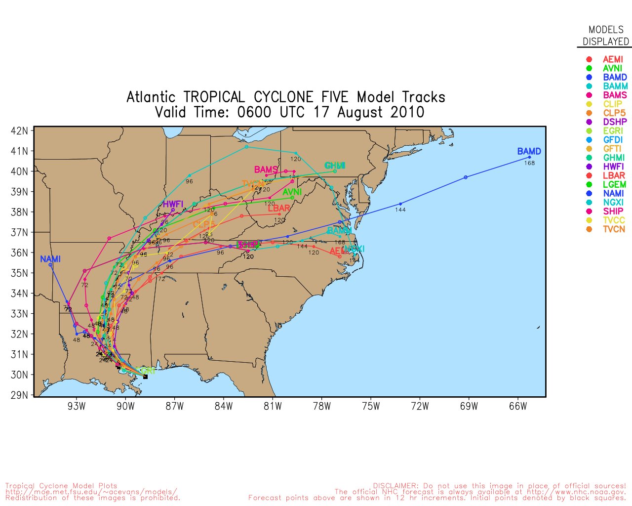
Clark Evans Track Model Plot of 93L
(Animated!) Model Plots in Google Earth - In Google Maps
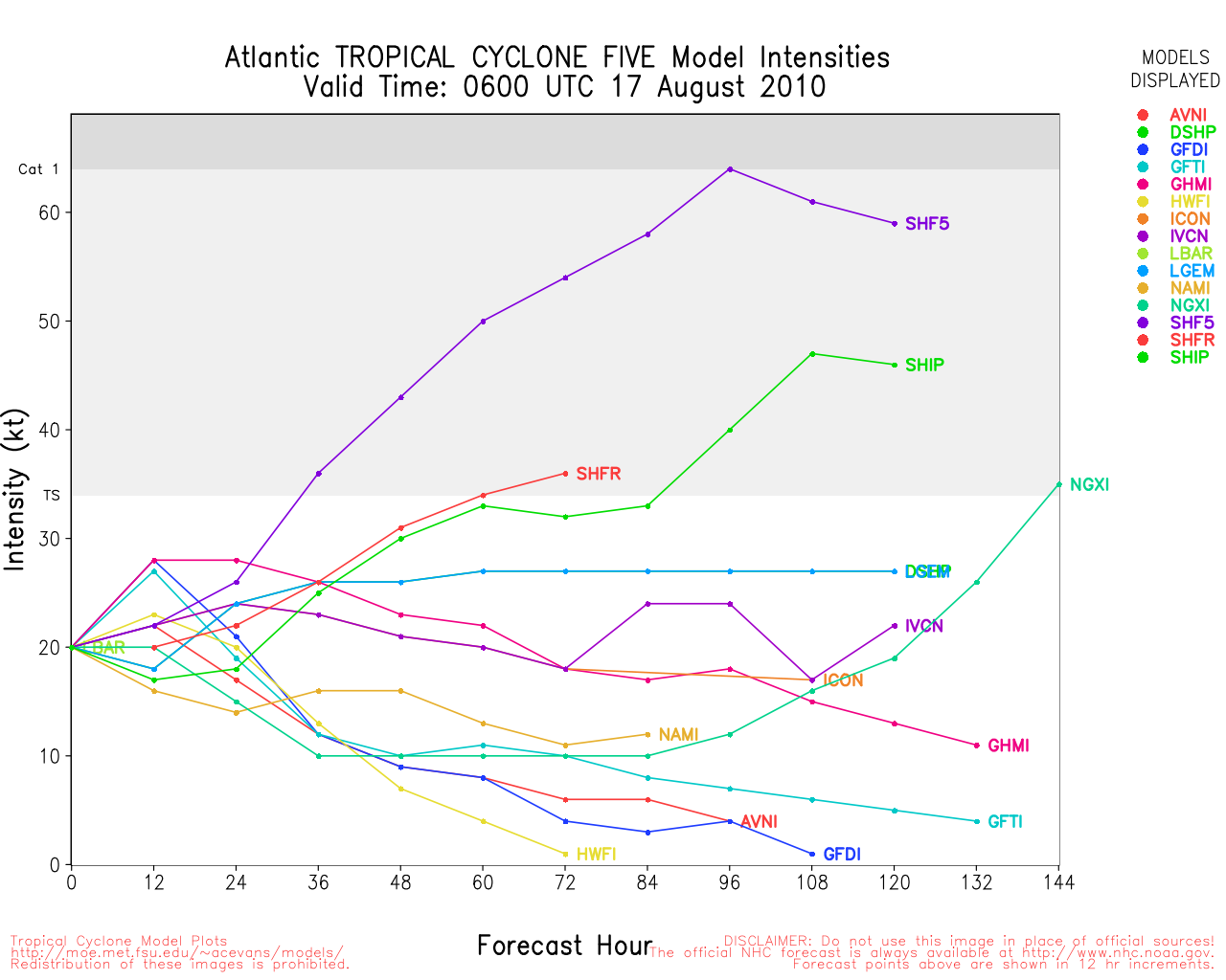
Clark Evans Intensity Model Plot of 93L (Animated!)
Clark Evans Track Plot of 93L
Other Model Charts from Clark
Clark Evans Top 10 Analog Storms for 93L
More model runs on from RAL/Jonathan Vigh's page
NRL Info on 93L -- RAMMB Info
COD Atlantic Satellite View
94L Event Related Links


SFWMD Model Plot (Animated Model Plot) SFWMD Hurricane Page
[https://flhurricane.com/floatanimator.php?year=2010&storm=6 Flhurricane Satellite Floater Animation of 94L
GOES Floater
Animated Model Plot of 94L
Clark Evans Track Model Plot of 94L
(Animated!) Model Plots in Google Earth - In Google Maps
Clark Evans Intensity Model Plot of 94L (Animated!)
Clark Evans Track Plot of 94L
Other Model Charts from Clark
Clark Evans Top 10 Analog Storms for 94L
More model runs on from RAL/Jonathan Vigh's page
NRL Info on 94L -- RAMMB Info
COD Atlantic Satellite View
StormCarib Reports from the Caribbean Islands
Caribbean Weather Observations
Barbados Brohav Weather Fax
Full Caribbean Radar Composite
Caribbean Broadcast Corporation (TV/Radio from Antilles)
San Juan, PR NWS Page
Various Caribbean Radio Stations
DR1 Dominican Republic Hurricanes
Update - Saturday - August 7, 2010 - 11AM EDT
Although the wind shear has decreased considerably, for a tropical storm Colin is a disorganized mess. The center of the minimal TS is exposed again with all of the unstructured convection displaced to the east and southeast. Colin has unexpectedly become stationary - stuck in an area of negligible winds (a COL area) between two upper level lows.
With a trough amplifying over the southeastern U.S., increasing southwesterly winds should eventually shove Colin off to the northeast. With less wind shear to contend with for the next 18 to 24 hours, some modest improvement in structure and increase in intensity is still possible - so a Tropical Storm Warning remains in effect for Bermuda.
ED
Original Post
Tropical Storm Colin looks more ragged this morning and may not hold Tropical Storm status long, the center is separate from the convection again, as it moves rapidly northwest. It is expected to miss Bermuda to the west, so that the island will see some effects from the storm.
Current Weather at Hamilton, Bermuda
Colin will likely then head toward the northeast as an system, perhaps clipping far eastern Newfoundland in Canada.
The area in the East Atlantic atlantic is being pushed northward and will likely stay well out to sea, if it develops it likely won't last long.
Beyond that there is nothing else, 92L is no longer being tracked. Anything else may not come until mid to late next week.
Bermuda Radar
|
MichaelA
Weather Analyst

Reged: Thu
Posts: 945
Loc: Pinellas Park, FL
|
|
Colin is heavily sheared this AM, but the shear and froward speed are forecast to abate somewhat in the next 24 hours according to the . Either Colin is doing a substantial wobble/loop, or the LLC is trying to move back under the convection to its east this AM, since the LLC is showing a due East movement in the latest loops.
--------------------
Michael
PWS
|
WesnWylie
Weather Guru
Reged: Sat
Posts: 155
Loc:
|
|
The has 92L back up on their satellite page. It is looking healthier this morning. I was looking at the forecast charts, and regardless of development, it would likely move into Central/Northeast Mexico.
Edited by WesnWylie (Fri Aug 06 2010 10:33 AM)
|
Fairhopian
Weather Watcher
Reged: Wed
Posts: 26
Loc:
|
|
I am still hoping someone smarter than me will entertain my question from yesterday morning:
"92L does have convection this morning and its upper level clouds appear to be somewhat aligned with its shallow clouds. Will the impending encounter with the upper ridge (to its immediate West) likely affect 92L's steering or rate of development? Watching what appears to be the "belt buckle" of 92L at 15N, 80W (I'm a former defensive back), its movement appears to be a little more north of due west in the last few frames. What does an upper ridge typically do to a tropical low crossing under it?"
While today's Tropical Discussion denotes a cyclonic turning in the NW Caribbean, the same thing was happening yesterday, though more attention was on Colin. Also, today's Tropical Discussion mentions how there is a lot of moisture in the upper levels of the NW Caribbean, and the base of the upper level ridge is causing a light easterly wind. I am curious about the interplay of 92L and that ridge. Any takers? Thanks.
|
danielw
Moderator

Reged: Wed
Posts: 3525
Loc: Hattiesburg,MS (31.3N 89.3W)
|
|
I'll try. A ridge would be akin to a linebacker line. Nothing would get through. It would probably deflect to the west as you posted the winds are light easterly winds.
I just checked the Western Caribbean buoys and while they are reflecting a pressure drop the winds aren't above 20 mph at this time. Pressure drop could be a diurnal/ twice daily pressure drop.
http://www.ssd.noaa.gov/goes/east/watl/wv-l.jpg
http://www.ssd.noaa.gov/goes/east/watl/loop-wv.html
ULL, upper level low in the BOC, Bay of Campeche, could draw 92L a bit further north. ( The Fujiwara Effect) .
I'm still trying to make some sense of all of the ULLs between Colin and 92L. If it help the models, several days ago, were forecasting 92L to track over the Yucatan Peninsula and into NE Mexico near Veracruz./ Tampico.
OFFSHORE WATERS FORECAST FOR THE GULF OF MEXICO
NWS TPC/NATIONAL HURRICANE CENTER MIAMI FL
1030 AM CDT FRI AUG 06 2010
GMZ089-062130-
SYNOPSIS FOR THE GULF OF MEXICO
1030 AM CDT FRI AUG 06 2010
.SYNOPSIS...RIDGE ALONG 29N DRIFT S AS WEAK FRONTAL TROUGH
PUSHES S INTO FAR NE WATERS. TROPICAL WAVE MOVE THROUGH BAY OF
CAMPECHE SUN AND MON. A WEAK LOW PRES SYSTEM WILL DEVELOP IN THE
NE GULF MON AND LINGER TUE.
Edited by danielw (Fri Aug 06 2010 05:08 PM)
|
stormtiger
Weather Hobbyist
Reged: Thu
Posts: 73
Loc: Baton Rouge, La.
|
|
It looks like conditions for 92L are becoming more favorable, but it is nearing land.
Something would have to start happening fast for 92L to develop before hitting land.
We have an ULL over the BOC?Western GOM and it doesn't seem to be in much of a hurry to get out of the way. Dry air is prevalent to the East of 92L, but 92L has blossomed somewaht today in a favorable are in the W Carribean. A ridge is present there, and conditions appear fine; but the TS activity isn't that great, yet.
There does seem to be some cyclonic twisting indicated on the visible satellite loops.
I think the likelehood of something developing is improving, but not to the "orange" level yet.
|
WesnWylie
Weather Guru
Reged: Sat
Posts: 155
Loc:
|
|
I think I see a spin in 92L around 84*W;18*N. I don't know if this is a mid-level or a low-level. The models show the center west-southwest of there. If the center is further north then the track would see a northward shift too. It really is looking healthy out there, though.
--------------------
2011 Season Forecast: 16/09/04
2011 Systems: 10/01/01
|
berrywr
Weather Analyst

Reged: Fri
Posts: 387
Loc: Opelika, AL
|
|
Okay, let's address a couple of features going on with 92L this evening. 92L looks pretty good on satellite imagery and looked even better not too long ago; a comment I posted about the not even make a mere mention of it until 5 pm today.
92L is approaching land and there is very little opportunity for 92L to be upgraded and not likely until it re-emerges in the Bay of Campeche in a couple of days; maybe 3.
A couple of features; there is an upper low in the Bay of Campeche, an upper ridge over 92L and an area of 20 knot shear aloft ahead of the system but otherwise light shear dominates the area over and ahead into the Western GOM.
A couple of things worth mentioning....upper ridges over tropical systems are what you want for tropical systems to develop into storms; because there is an upper ridge over a shallow system the interaction between the two is not of that between an upper ridge and a hurricane.
The Upper Level Low to the NW of 92L will have no Fujiwara; 92L is simply too shallow to be steered by the Upper Level Low in this fashion. There is minimum gradience between this ULL and the ridge over 92L to have any degree of impact until 92L becomes much more organized. A Fujiwara is akin to two identical magnetic charges facing one another and repelling each other; that simply is not the case here/
This system will have to be monitored onces it emerges back in the BOC as some models have a break in the two ridges over the US and Atlantic Ocean and it will be interesting to see if it will interact with the evolving long wave trough pattern setting up over the Eastern US. There is a sagging front in the SE USA that will have to be monitored if it enters the GOM and goes stationary.
I commend the thinking and comments on this system...good work all!
--------------------
Sincerely,
Bill Berry
"Survived Trigonometry and Calculus I"
Edited by berrywr (Fri Aug 06 2010 08:24 PM)
|
Ed Dunham
Former Meteorologist & CFHC Forum Moderator (Ed Passed Away on May 14, 2017)
Reged: Sun
Posts: 2565
Loc: Melbourne, FL
|
|
Given the question that was asked, danielw's analog is still a good one, since there is also quite a difference between the (usually rather small) anticyclone created by a mature hurricane (to the right of its movement in the Northern Hemisphere) and a synoptic scale upper level blocking ridge.
One more correction - From the Glossary:
" Fujiwhara Effect:
The tendency of two nearby tropical cyclones to rotate cyclonically about each other. "
Their is no Fujiwhara effect when one of the systems is an upper level low - however, the ULL can contribute to the motion of a tropical cyclone.
ED
|
danielw
Moderator
Reged: Wed
Posts: 3525
Loc: Hattiesburg,MS (31.3N 89.3W)
|
|
Thanks, Guys.
I hadn't though of surface lows and upper level lows not being effected by Fujiwhara. Different levels in the atmosphere. Learn something here everyday.
SE tail of the 93L thumbnail looks like a good area to watch today.
Edited by danielw (Sat Aug 07 2010 06:59 AM)
|
mwillis
Weather Hobbyist

Reged: Wed
Posts: 68
Loc: Cape canaveral
|
|
It appears the the coc moved a little to the ese in the last couple of frames. That is unless im seeing this incorrectly, lol
http://www.ssd.noaa.gov/goes/flt/t1/flash-vis.html
|
berrywr
Weather Analyst
Reged: Fri
Posts: 387
Loc: Opelika, AL
|
|
Don't be afraid to ask us; that's what were here to do and at the same time don't feel as if we're ever putting each of you down if you're wrong; you'd be amazed how often we're wrong or what we think is going to happen and it doesn't. Look at Colin this evening; amazing thing happened today; the center and convection are now together and looking quite well on satellite imagery this evening. Though it's days are now measured before becoming a garden variety cold core low and eventually absorbed into a bigger low...that's what its all about. Keep asking and we'll keep answering; yall have a nice evening.
--------------------
Sincerely,
Bill Berry
"Survived Trigonometry and Calculus I"
|
danielw
Moderator
Reged: Wed
Posts: 3525
Loc: Hattiesburg,MS (31.3N 89.3W)
|
|
Excerpts from various NWS Morning Forecast Discussions:
AREA FORECAST DISCUSSION
NATIONAL WEATHER SERVICE NEW ORLEANS LA
248 AM CDT SUN AUG 8 2010
MODELING CONTINUES TO DEVELOP AN INVERTED TROUGH ALOFT WITH A BROAD
AREA OF SURFACE LOW PRESSURE OVER THE NORTHERN BAHAMAS ON LATER
TODAY OR TOMORROW THAT MOVES WEST INTO THE GULF OF MEXICO OFFSHORE
OF SOUTHWEST FLORIDA ON TUESDAY THEN TRACKS NORTHWEST TOWARDS
SOUTHEAST LOUISIANA ON WEDNESDAY. THIS AREA OF LOW PRESSURE WILL
BRING AN INCREASE IN SHOWERS AND THUNDERSTORMS BEGINNING ON
WEDNESDAY WITH NORTHEAST TO EAST WINDS. SHOULD THIS AREA OF LOW
PRESSURE DEVELOP AS CURRENT MODELING SUGGESTS...IT WILL BE MONITORED
CLOSELY FOR SIGNS OF FURTHER TROPICAL CYCLONE DEVELOPMENT.
AREA FORECAST DISCUSSION
NATIONAL WEATHER SERVICE MIAMI FL
418 AM EDT SUN AUG 8 2010
THERE IS GENERAL AGREEMENT IN THE MOST RECENT SUITE OF MODEL
GUIDANCE THAT THE LOW LEVEL TROUGH MENTIONED ABOVE WILL CONTINUE
TO MOVE SOUTHWEST TODAY AND TONIGHT AND COULD PASS ACROSS SOUTH AND
CENTRAL FLORIDA ON MONDAY...WITH A SURFACE LOW POSSIBLY FORMING AS
THE TROUGH DEEPENS. THIS SCENARIO CONTINUES TO MAINTAIN HIGH
CHANCES OF CONVECTION ACROSS SOUTH FLORIDA ON MONDAY. THE GUIDANCE
THEN SUGGESTS THAT THE LOW LEVEL TROUGH CONTINUES TO MOVE WEST INTO THE
EASTERN GULF ON MONDAY NIGHT INTO TUESDAY AND CONTINUES TO FORM A
SURFACE LOW...MAINTAINING VERY MOIST CONDITIONS ACROSS THE REGION
WITH A HIGH CHANCE OF CONVECTION.
AREA FORECAST DISCUSSION
NATIONAL WEATHER SERVICE MOBILE AL
436 AM CDT SUN AUG 8 2010
MONDAY NIGHT WOULD BE A HARBINGER OF RELATIVELY DRY WEATHER. A
DECREASE OF WATER VAPOR AVERAGES FROM 1000-500 MB IS EXPECTED TO
COMMENCE OVER THE AREA AS CYCLOGENESIS BEGINS OVER THE OLD FRONT IN
THE NE GMEX AND THE RESULTANT LOW MOVES WEST. WE NOTE THAT THESE
TYPES OF LOWS CAN SOMETIMES ACHIEVE TROPICAL CHARACTERISTICS.
MOISTURE POOLED ALONG THE SOUTHWARD DRIFTING FRONT WILL MAINTAIN A
DEEP LAYER OF AVAILABLE WATER VAPOR, RH BEING BETWEEN 60 AND 70
PERCENT, OVER THE AREA THROUGH MONDAY. MOISTURE COMBINED WITH
INSTABILITY OFFSHORE WILL GENERATE SCATTERED SHOWERS AND
THUNDERSTORMS OVER THE GULF DURING THE MORNINGS, WITH SUNLIGHT
PROVIDING THE INSTABILITY OVER LAND TO BRING SCATTERED TO NUMEROUS
SHOWERS AND THUNDERSTORMS MONDAY. TUESDAY AFTERNOONS. AS THE
AFOREMENTIONED LOW DEVELOPS OVER THE GULF, RELATIVELY DRY AIR FROM
THE PIEDMONT REGION WILL BE DRAWN OVER THE AREA AS IT ROTATES AROUND
THE AREA OF CYCLOGENESIS ON TUESDAY.
Edited by danielw (Sun Aug 08 2010 11:16 AM)
|
stormchazer
Storm Tracker

Reged: Tue
Posts: 315
Loc: Central Florida
|
|
AL 94 2010080812 BEST 0 303N 786W 25 1011 DB
Off the Florida east coast.
--------------------
Jara
*************************************************************
|
danielw
Moderator
Reged: Wed
Posts: 3525
Loc: Hattiesburg,MS (31.3N 89.3W)
|
|
Thanks,
CARCAH, National Hurricane Center, MIAMI, FL.
1100 AM EDT SUN 08 AUGUST 2010
SUBJECT: TROPICAL CYCLONE PLAN OF THE DAY (TCPOD)
VALID 09/1100Z TO 10/1100Z AUGUST 2010
TCPOD NUMBER.....10-070 CORRECTION
I. ATLANTIC REQUIREMENTS
1. NEGATIVE RECONNAISSANCE REQUIREMENTS.
2. OUTLOOK FOR SUCCEEDING DAY: POSSIBLE LOW LEVEL
INVEST IN E. GULF NEAR 26.5N 83.5W AT 10/1800
*********************************************
MARINE WEATHER DISCUSSION
NWS TPC/NATIONAL HURRICANE CENTER MIAMI FL
820 AM EDT SUN AUG 08 2010
SIGNIFICANT CHANGES IN THE MODELS SINCE THIS TIME YESTERDAY WITH
THE LOW EXPECTED TO PINCH OFF THE FRONTAL TROUGH OVER CENTRAL
FLORIDA. THE ..ECMWF...AND UKMET ALL SHOW A MUCH MORE
ORGANIZED LOW PRES SYSTEM DEEPENING OVER THE EASTERN GULF MON
AND MOVING WEST-NORTHWEST TOWARD LOUISIANA BY THU COMPARED TO
THEIR RUNS THIS TIME YESTERDAY. THE IS SIGNIFICANTLY WEAKER
AND FARTHER E WITH THE TRACK IN THE GULF...BUT IT HAS BEEN
SLOWLY TRENDING TOWARD THE OTHER MODELS THE LAST FEW DAYS. THE
HPC/NHC NOON MEDIUM RANGE CALL SAT CALLED FOR A COMPROMISE
BETWEEN THE AND TRACK WHICH CARRIES A TUE MORNING LOW
POSITION NEAR 29N82W AND BRIEFLY MOVES IT INTO THE FAR NE GULF
BEFORE CARRYING IT INTO THE FLORIDA PANHANDLE NEAR 30N85W WED
MORNING. THESE POINTS WERE TWEAKED TOWARD THE CONSENSUS OF THE
ECMWF...UKMET...AND WHICH WERE FARTHER SOUTHWEST WITH THE
TRACK AND ALLOWED THE LOW MORE TIME OVER THE GULF WATERS.
EARLY MORNING OBSERVATIONS OVER NORTH FLORIDA SHOW A CLEAR WIND
SHIFT SUGGESTING THE PASSAGE OF A FRONTAL TROUGH. THE SATELLITE
SIGNATURE NEAR BUOY 41010 THIS MORNING SUGGESTS THERE MAY BE A
WAVE DEVELOPING ALONG THE BOUNDARY. THE MODELS SUGGEST THE
DEVELOPMENT OF A MID LEVEL LOW SOMEWHERE OVER CENTRAL FLORIDA
TONIGHT OR MON...BUT THEY ARE NOT SURE OF THE DETAILS. BY
TUE...THE UKMET...ECMWF...AND COME INTO EXCELLENT AGREEMENT
ON A RETROGRADING AND DEEPENING LOW PRES SYSTEM IN THE GULF OF
MEXICO BORN FROM THE ENERGY ASSOCIATED WITH THIS FRONTAL TROUGH
WHILE THE IS WEAKER AND MORE NORTHERLY WITH THE SYSTEM. THE
GFS HAS BEEN PLAYING CATCH UP HERE. GIVEN THE CURRENT SATELLITE
IMAGERY...IT APPEARS THE HAS THE BEST HANDLE ON THE
DEVELOPMENT NEAR FLORIDA FOR NOW. PLEASE SEE THE DISCUSSION IN
THE GULF OF MEXICO SECTION FOR MORE DETAILS ON THIS SYSTEM.
(contents in the first paragraph)
http://www.srh.noaa.gov/data/NHC/MIMATS
Edited by danielw (Sun Aug 08 2010 11:37 AM)
|
mwillis
Weather Hobbyist
Reged: Wed
Posts: 68
Loc: Cape canaveral
|
|
I think i see a coc forming on radar near the letter E in Fort Pierce off the east seaboard. Does anyone else see it?
http://radar.weather.gov/radar.php?rid=MLB&product=N0Z&overlay=11101111&loop=yes
|
Ed Dunham
Former Meteorologist & CFHC Forum Moderator (Ed Passed Away on May 14, 2017)
Reged: Sun
Posts: 2565
Loc: Melbourne, FL
|
|
Satellite confirms the possibility. In developing systems its worth remembering that multiple cyclonic spinups will occur within the system. Eventually as the system evolves one center predominates.
ED
|
danielw
Moderator
Reged: Wed
Posts: 3525
Loc: Hattiesburg,MS (31.3N 89.3W)
|
|
SPECIAL WEATHER STATEMENT
NATIONAL WEATHER SERVICE MELBOURNE FL
1259 PM EDT SUN AUG 8 2010
FLZ054-059-081800-
INDIAN RIVER-ST. LUCIE-
1259 PM EDT SUN AUG 8 2010
...FUNNEL CLOUDS AND WATERSPOUTS POSSIBLE OVER SOUTHEASTERN INDIAN
RIVER COUNTY...NORTHEASTERN ST. LUCIE COUNTY...
AT 1252 PM EDT...NATIONAL WEATHER SERVICE METEOROLOGISTS DETECTED A
LINE OF STORMS CAPABLE OF PRODUCING FUNNEL CLOUDS AND STRONG WIND
GUSTS UP TO 40 MPH OVER INDIAN RIVER SHORES...MOVING SOUTHEAST AT 10
MPH.
LOCATIONS IN THE PATH OF THE STORM WHICH MAY EXPERIENCE GUSTY WINDS
AND FUNNEL CLOUDS INCLUDE QUEENS COVE AND SOUTH BEACH.
WATERSPOUTS CAN MOVE ONSHORE AND PRODUCE BRIEF...SMALL TORNADOES.
MOVE INDOORS AND STAY AWAY FROM WINDOWS.
|
EMS
Weather Hobbyist
Reged: Tue
Posts: 55
Loc: St. Petersburg, Florida
|
|
Not sure, but there appears to be rotation visible from Melbourne long range radar. It was located about 100 miles due east of Melbourne and has moved just west of due south over the last 45 minutes. It is now almost due west of Fort Pierce. Could that be a developing COC?
Edited by EMS (Sun Aug 08 2010 07:07 PM)
|
rgd
Weather Hobbyist
Reged: Sun
Posts: 65
|
|
Quote:
Not sure, but there appears to be rotation visible from Melbourne long range radar. It was located about 100 miles due west of Melbourne and has moved just west of due south over the last 45 minutes. It is now almost due west of Fort Pierce. Could that be a developing COC?
Not really it is just a low that is going to move across the state and get us dryer tomorrow then maybe some backside precip on tuesday but a coc? no just a low that is bringing some much needed rain to my area that is about all this will be.
|


 Threaded


