MikeC
Admin
Reged:
Posts: 4544
Loc: Orlando, FL
|
|
1:00PM EDT Update - Thursday, 26 August 2010
97L is now being tracked, this is the wave east of Earl, and has a chance to form tomorrow or over the weekend. Odds favor this recurving as well, but has even less confidence than Earl.
7:00AM EDT Update - Thursday, 26 August 2010
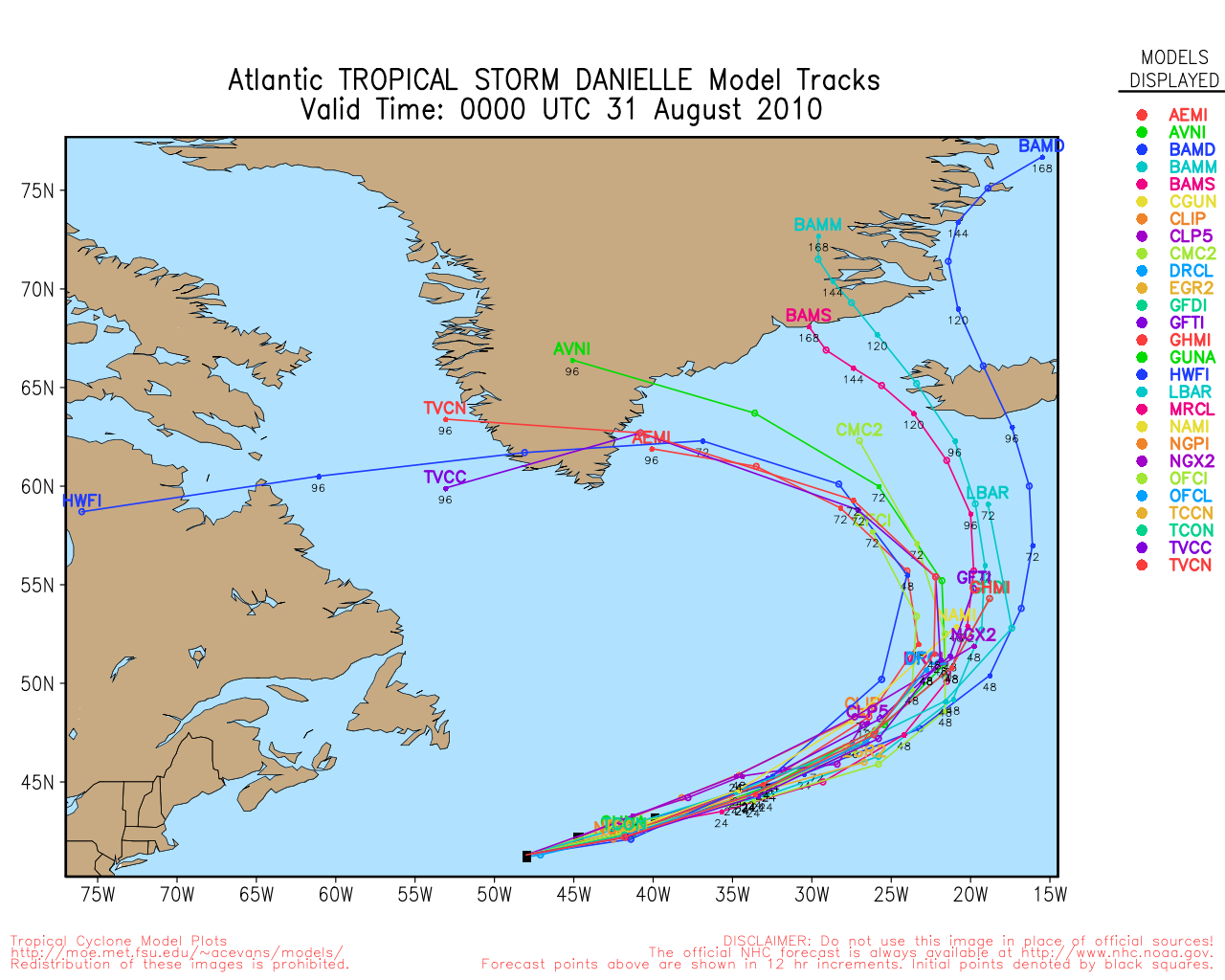
There are two active storms in the Atlantic this morning. Hurricane Danielle, which is recurving rather abruptly, and looks like it will miss Bermuda comfortably to the east. Danielle has another window to strengthen tomorrow into Saturday, where it still may reach major status.
Tropical Storm Earl is moving generally west northwest right now. Odds are increasing that it will recurve and miss the Caribbean islands as the weakness between 55 and 60 degrees west looks to be maintained throughout the week. This recurving is quit normal for cape Verde systems. Bermuda may have to watch Earl later, but odds favor it being missed as well. If anything changes we'll note it.
(11 AM Mini Earl Update): The hurricane center mentions a point about Earl (and Danielle) at the 11AM discussion, basically saying if Danielle recurves faster and or more abruptly than forecast, it could give a window for the ridge to reform near earl, keeping it a bit further west than the current track, which would possibly bring the Eastern Caribbean back in play. Odds are against it, but if Earl's forecasted path were to change, that would be one of the reasons why, and something to watch for.
Beyond that, the pattern probably holds into the first part of September, so odds are the wave emerging from the African coast will recurve as well around the same place. But that far out becomes a bit more uncertain. It is possible we'll have three storms to track by the end of the weekend.
The good news is that the recurve pattern looks to last into perhaps the first week of September. But unfortunately after that the pattern may start to change. However, it's still important to be vigilant for anything that develops closer to land is more of a risk, but there is nothing imminent.
The only affect along the US from these systems will be slightly higher surf, which could cause some swells, large waves and rip currents in some areas.
The area in the Gulf missed its chance to develop and will just bring some rain to Texas.

* hasn't updated 97L yet, actual system is off the coast of Africa *
5:00PM EDT Update - Wednesday, 25 August 2010
Tropical Storm Earl has formed in the East Atlantic, it is forecast to become a hurricane by Friday. Odds currently favor Earl going out to sea, but the odds are not as solid as they were for Danielle. Those in the Eastern Caribbean islands will want to watch for any changes in the forecast track.
8:00AM EDT Update - Wednesday, 25 August 2010
96L appears to be reaching tropical Depression status this morning on visible satellite imagery and likely will begin advisories on Tropical Depression 7 at 11 AM EDT. Most likely forecast track for it takes it mostly west, then curves north and out to sea well before the Caribbean.
6:30AM EDT Update - Wednesday, 25 August 2010
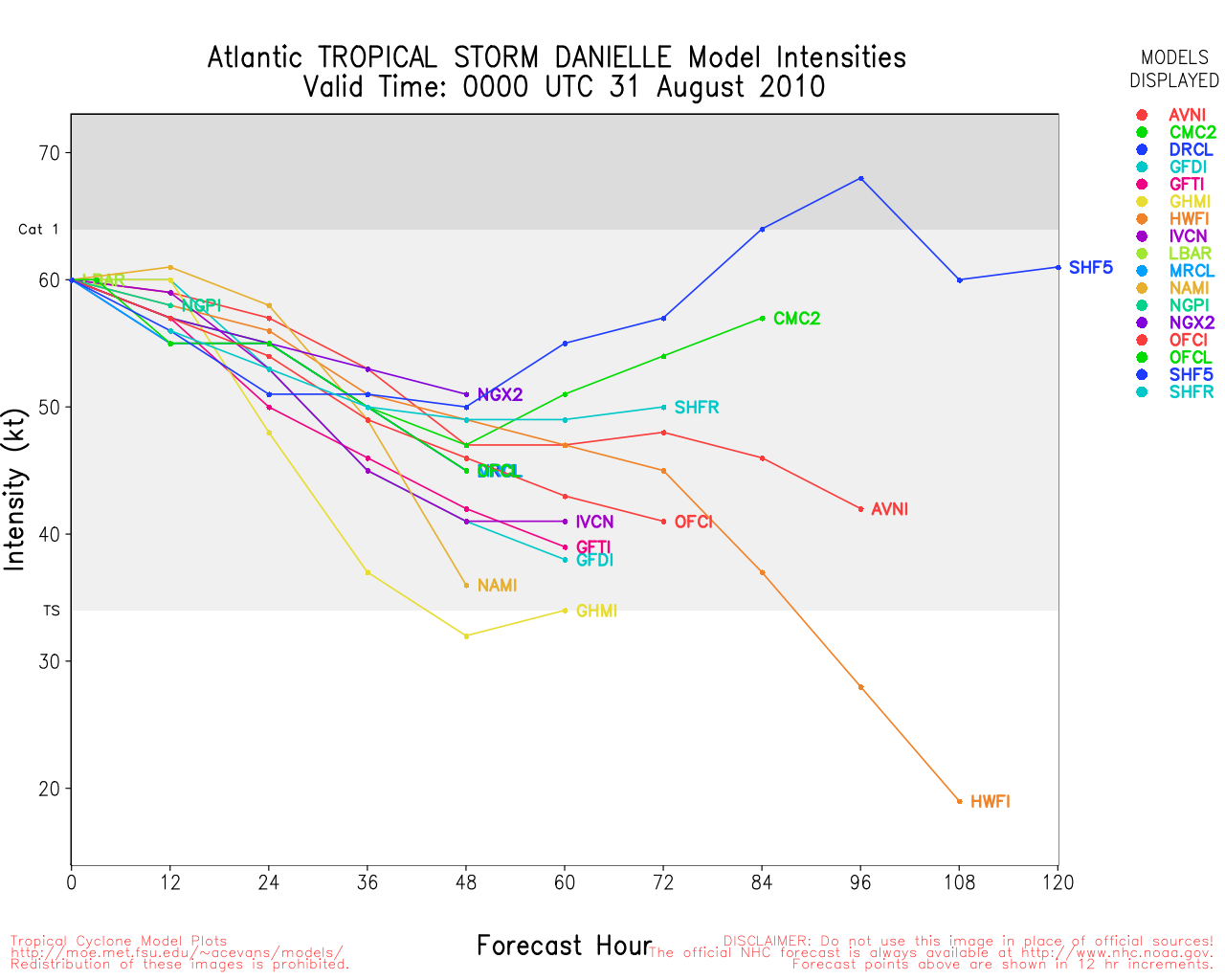
Hurricane Danielle has maintained itself well overnight and has a chance to strengthen a bit more after a day or two when the upper level low currently negatively affecting Danielle moves more southwesterly.
Track wise, odds still favor no direct impact to land, however Bermuda is in the cone and should watch, but what's most likely is that it should pass enough to the east to avoid the worst of it. Still those in Bermuda should watch closely for any changes.

Model runs that showed a more westerly move last night have moved back to the east, and some much further to the east.
The area behind Danielle (96L) has not yet developed, but still has a chance today to become a depression, and odds still favor it staying away from land areas.
The gulf system has a small chance to develop, but isn't very likely. If it were it wouldn't do it until Friday into the weekend and it won't have much time to strengthen if it does.
8:45PM EDT Update - Tuesday, 24 August 2010
Danielle has weakened a bit today, but is on it's way back to a hurricane tonight and likely will recover.
Odds still favor no US land impact, but Bermuda is in the western forecast cone, and may need to watch the system. Longer range forecasts are a bitty iffy, but still the highest odds keep it away from land.
The wave behind Danielle (96L) Did not develop so far today, but may later tonight or tomorrow. Odds still favor this system staying out to sea as well.
The area in the Gulf has a 10% chance to develop, but is not being tracked as an investigation currently. Odds are that it will not, but if it were it would be Friday into the weekend.
You can find long range discussions/guesses on the Gulf System Here, and the same for Danielle here (including models).
7AM EDT Update - Tuesday, 24 August 2010
Hurricane Danielle has strengthened to a category 2 hurricane overnight, but has lost the eye feature that was visible last night. It has had a bit of dry air intrusion, which may keep the storm from reaching major today. It still has a chance to later, but first Danielle may actually weaken a bit, and may never make it back up that high The forecast track (and odds) still takes it out to sea regardless of strength.
Danielle is forecast to slow forward motion and begin moving more northward. Bermuda is barely in the cone, but chances of direct effects of the system are low for there.
The wave behind Danielle, 96L, may form into a depression later today. This system has a pretty good shot at developing with a 90% chance (as of 80%). It likely won't get as strong as Danielle, but it has a chance to develop none the less. Still, the most likely outcome, currently, for track on this system keeps it out to sea, following in the wake of Danielle.
Those in the Cape Verde Islands themselves, may see some effects from 96L.

Beyond that, another wave may exit the coast of Africa, and that one has a chance to stay further south and west. Those may be worth watching later this week into next week. And there is also possibility something in the Gulf could form closer to home late this weekend into next week, but there is nothing solid there.
The tropics will likely be busy over the next few weeks, so be prepared.
5PM EDT Update - Monday, 23 August 2010
Danielle has become a hurricane, the second of 2010 for the Atlantic. The forecast track keeps it far out to sea from the Caribbean and United States. It is likely to undergo rapid intensification and become this year's first major hurricane. Which, thankfully, will stay far away from land.
Behind Danielle is another tropical wave being watched that could form over the next few days, this system will likely follow Danielle out to sea.
In short, the tropics are starting to heat up again, but there is nothing approaching any land.
2PM EDT Update - Monday, 23 August 2010
Danielle appears on it's way to becoming a hurricane by tonight or tomorrow, but odds are it will stay out to sea. Danielle is likely to become this year's first major hurricane, but thankfully well away from any land areas.
Behind Danielle is another system, 96L which also has the potential to develop this week, and may do so tomorrow or Wednesday. It has a 40% chance to develop right now, and odds are this too will stay out to sea. It likely won't become as powerful as Danielle, and Danielle may keep it from doing so.
Beyond 96L, another wave may come off Africa and form, and that one could be something to keep a close eye on.
11AM EDT Update - Monday, 23 August 2010
Although still experiencing some easterly shear, Tropical Storm Danielle continues to intensify at a steady rate and is again expected to attain hurricane strength by late tonight or early Tuesday as the shear will be relaxing this evening. After a westward trend during the night, Danielle is now moving to the west northwest and a more northwesterly track is likely tonight as the cyclone approaches a weakness in the ridge near 45W. After turning to the northwest, believes that a western Atlantic ridge will force Danielle on a track more to the north northwest - which seems like a reasonable scenario, however, since the westward motion last night was not anticipated, folks in the northern Leeward Islands should continue to monitor Danielle's progress for any unexpected changes.
ED
11AM EDT Update - Sunday, 22 August 2010
The organization phase of TD6 has stalled for the moment as the system has encountered strong northeasterly shear that has displaced most of the convection to the southwest of the exposed center. Movement for the past few hours has been almost due north at about 8 knots, however, a more west northwest motion should resume later today as the system moves away from strong tropical east to northeast winds.
Both the intensification outlook and the eventual track of TD6 will require some adjustment because of the disruption and delay of the current system development and the slowdown in forward motion toward the west - both current motion and forecasted movement. A slower and less aggressive intensification process should eventually bring TD6 to hurricane strength on Wednesday. The development of a mid-Atlantic trough is now anticipated to have less influence on the future track - and that track is a little less obvious than it was yesterday.
Other systems that may influence the wind flow patterns in the Atlantic include a rather intense Upper Level Low over the southern Bahamas, another ULL near 26N 43W and a new active and slowly developing tropical wave near 12N 22W at 22/15Z. Just as rapidly as conditions changed from yesterday to today, they can change again from today to tomorrow or the next day, so stay tuned.
ED
Original Post
Tropical Depression six has formed in the Eastern Atlantic, and is forecast to become a hurricane sometime Monday. The good news is that it will stay far away from any land areas.
The system has a good chance to become the first major hurricane of the season, and may generate some minor swells along the east coast, but that will be the extent of the impact.
Outside of this, there likely won't be much else to track until mid-week.
|
typhoon_tip
Meteorologist
Reged:
Posts: 576
|
|
Perhaps temporary, but the low and mid level centers appear to be decoupling in recent higher resolution visible imagery.
Currently TD6 is in a moderate ENE shearing, which more than likely is the culprit for looking rather exposed during the morning hours. In about 24 to 36 hours ...assuming this system lasts that long, the depression will be moving away from this region of shear; should that be the case it will find its self in an ever improving arena for the next 2 -3 days, which would offer solid opportunity for unimpeded development.
Track guidance has shifted left to varying degrees among the global numerical models over the past 24 hours. The reason for this is understandable to me. The North Atlantic Oscillation phase is currently rising and forecast to continue to do so right out through the end of the middle and extended range (D6-10). The evolution of that would argue for strengthening subtropical ridging, particularly in the western 1/3 to 1/2 of the Atlantic Basin, not troughs digging into 50W enough to induce a quick polarward motion. The solution from 00Z last night did in fact back off on that idea from 12Z yesterday.
All told this would tend to dictate a left adjustment in track guidance in future runs, barring the pattern just doesn't evolve as currently modeled to do so. Obviously, the corrective assumptions are predicated on the +NAO related substantive subtropical ridging behaving accordingly...
Edited by typhoon_tip (Sun Aug 22 2010 04:40 PM)
|
WeatherNut
Weather Master
Reged:
Posts: 412
Loc: Atlanta, GA
|
|
The in the 11am discussion seemed to imply that the decoupling was due to the disturbance to the NE of TD6. Looking at recent SAT loops that area is starting to diminish probably because it is entering the drier air and cooler water. I wonder how much longer this influence will remain, or if this is mostly due to shear
--------------------
Born into Cleo (64)...been stuck on em ever since
|
weathernet
Storm Tracker
Reged:
Posts: 296
Loc: Elsewhere
|
|
Just to "piggy-back" on the recent images of a low level vort. center decoupling; ti will be interesting to see whether this feature is simply the de-facto center that is simply going to rotate back westward and co-locate with the broader convective mid level circulation. If so, than a northerly course adjustment would have to be made by . I do not think this will turn out to be the case however. Even up to early this morning, the depression center maintained an elongated N.E./S.W. appearance and still in a formative stage with regards to having a well defined center. Should the low/mid level trades continue to rapidly push the larger envelope of this system more or less towards the west in the short term, and a new low level center form underneath, than significant changes to forecast may indeed be forthcoming.
|
typhoon_tip
Meteorologist
Reged:
Posts: 576
|
|
I think what they were referring to was specifically the reason why the N motion in the low level vortex has taken place. By this I am assuming the disturbance NE has some lowered pressure and is causing some weakness in that vicinity, drawing the vortex polarward as an indirect influence.
It was an interesting supposition on their part, and though I do not have all the tools they do for their analysis, from here it really does appear to be shear as the primary reason for the decoupling its self. The mid and high level wind overlays clearly show 15-25kts flags incurring upon the eastern semi-circle from the E and ENE.
|
MichaelA
Weather Analyst

Reged:
Posts: 944
Loc: Pinellas Park, FL
|
|
Convection has begun to flair up over the LLC again this afternoon. We'll see if it gets sheared off again.
--------------------
Michael
PWS
|
typhoon_tip
Meteorologist
Reged:
Posts: 576
|
|
Quote:
Convection has begun to flair up over the LLC again this afternoon. We'll see if it gets sheared off again.
Still seeing shear tend to displace the convection you have noted toward the West... Although, it appears the cyclone has resumed more westerly component to it current track, which is helping to mitigate that shear to some degree. Nonetheless, it is not preventing some development from succeeding.
Danielle has been officially named as of the 5pm advisory
Edited by typhoon_tip (Sun Aug 22 2010 11:44 PM)
|
MichaelA
Weather Analyst
Reged:
Posts: 944
Loc: Pinellas Park, FL
|
|
Current IR (unenhanced) sat loop shows quite a robust has formed over the center. Looks like some good intensification is going on now. Very cold cloud tops on the enhanced pics.
--------------------
Michael
PWS
|
typhoon_tip
Meteorologist
Reged:
Posts: 576
|
|
Quote:
Current IR (unenhanced) sat loop shows quite a robust has formed over the center. Looks like some good intensification is going on now. Very cold cloud tops on the enhanced pics.
It appears to me that the centroid axis of the llv vortex is probably closer to the eastern edge of that impressive region of cold cloud tops.
Nonetheless ... I am in general agreement here that intensification is probably underway; one clue to that is the persistence in the , or -like feature. Quite perpetual and increasingly symmetric in time.
Other notable is that the motion has corrected smartly west, though in keeping with the necessitated 6-hourly mean the motion would have to be WNW for the time being.
The 18Z run decided to abruptly break trend, both with regard to the TC, and the entirety of the local hemispheric synoptic evolution; such continuity shifts over such huge mass fields of this nature seldom demonstrate much skill.
Edited by Ed Dunham (Mon Aug 23 2010 02:51 AM)
|
typhoon_tip
Meteorologist
Reged:
Posts: 576
|
|
Danielle has strengthened to a 50mph tropical storm this evening.
I have noticed that the deep convective cloud pattern has taken on much more cyclonic banding more centroid to the apparent or -like feature that rather abruptly exploded 3 hours ago. It is not uncommon for early developing TCs to have center jumps toward regions where UVM is persisting (the reasons can get complicated).
In any case, what appeared to be a deep plume of convection perhaps displaced slightly W of the llv circulation axis earlier this evening has become more collocated with the on-going rigorous and persistent of -like feature.
Also, the TC is moving more W by WNW and this forward motion is a negative vector against the incursion of ENE shear, such that storm relative shear has dropped off. That is similar to sticking your hand out a window while driving at 10 mph, with a wind at your tale of 20mph - you only experience a wind differential of 10mph. The same arithmetic applies in the atmosphere, such that a TC moving W at 10 mph with easterly shear of 20mph, only experiences 10 mph of bulk shear; which is not sufficient enough in most cases to prevent strengthening.
Any deep layer convection in that vicinity would be compelled to move more W given the surrounding environmental flow. When the convection erupted closer to the center of circulation earlier this evening, the center was pulled W and is now being guided again by a better coupled lower and middle atmospheric dynamic, both of which are then guided by the mid-level steering.
John
|
danielw
Moderator

Reged:
Posts: 3525
Loc: Hattiesburg,MS (31.3N 89.3W)
|
|
Latest satellite imagery strongly supports Tip's analysis of the near or -type structure in the center of the system.
Recent images of varying enhancements are indicating a spike in the cloud tops just to the west of the central area. Probably a convective hot tower-CHT. Also noted is a small circular area just to the east of the CHT. Some slight indication of an eye-like structure using several image enhancements.

Outflow channels are seen in early stages to the northwest and along the lower periphery of the system. Near and along the .
Current tropical forecast points indicate the CHTs are nearly one degree south of the 23/ 12Z position. This would take the system on a more West or WNW track as Tip stated above. Still plenty of room for the storm to turn back on track.
Is the lack of separation from the prolonging the westward track?
|
MikeC
Admin
Reged:
Posts: 4544
Loc: Orlando, FL
|
|
It's important to note that the track forecast Danielle's apparent westward jog was due to a recenter (with new microwave imagery) and not to more westerly movement. I think it has a good shot at becoming a major, but odds highly favor it moving north and out to sea well before any land areas.
The area in the Gulf needs a lot more time for development, and the area east of Danielle is going to face a rough time developing until later in the week, if it does at all. It has a 40% chance or so.
|
Ed Dunham
Former Meteorologist & CFHC Forum Moderator (Ed Passed Away on May 14, 2017)
Reged:
Posts: 2565
Loc: Melbourne, FL
|
|
Actually in a way you were both correct. There was a recenter at 09Z, but from 09Z till 12Z the latitude was unchanged at 14.8N - and Danielle moved west at 20mph during those three hours.
ED
|
typhoon_tip
Meteorologist
Reged:
Posts: 576
|
|
Quote:
Actually in a way you were both correct. There was a recenter at 09Z, but from 09Z till 12Z the latitude was unchanged at 14.8N - and Danielle moved west at 20mph during those three hours.
ED
Thanks Ed ... Yes, I noted that behavior too but figured it was a protracted minor issue to get into it...
I am actually interesting (somewhat) in the fact that the guidance would have had this moving WNW by now and to the best of my ability I see a near straight west motion over the last 6 hours. 6 hours ago the perceived center was between the 15th and 16th parallels, and that is still where it is now.
Probably this is a system destined to eye candy and nothing more. The only other solution I can imagine is if the weakness somehow proves inadequate to pull it up, then the subtropical ridge amplification associated withe MA/NE heat wave later in the weekend would pin it into the SW Atlantic Basin as a drifter.
System behind this one is flared higher interest at at this point, as well.
Edited by typhoon_tip (Tue Aug 24 2010 02:21 AM)
|
WeatherNut
Weather Master
Reged:
Posts: 412
Loc: Atlanta, GA
|
|
It also looks to me like a westward movement. If it does miss this weakness, will it continue westward. with it being a stronger system will it be steered more by the 200-300mb layer flow? Looking at the latest graphics from CIMSS, thats what it looks like
--------------------
Born into Cleo (64)...been stuck on em ever since
Edited by WeatherNut (Tue Aug 24 2010 01:56 AM)
|
typhoon_tip
Meteorologist
Reged:
Posts: 576
|
|
Quote:
It also looks to me like a westward movement. If it does miss this weakness, will it continue westward. with it being a stronger system will it be steered more by the 200-300mb layer flow? Looking at the latest graphics from CIMSS, thats what it looks like
Track guidance beyond 72 hours is very difficult. There's just no way to know... For many runs, the numerical guidance had this weakness missing, now for a the last 18 hours (or 3 cycles worth) they have unanimously trended toward it turning smartly N and moving unimpeded right up the 50th parallel or so. The 18Z runs of a few of these show an interesting bend back W around 84 hours or so, which "could" be an early indicator for troubling times ahead in the modeling.
As I was mentioning to Ed, if it misses the weakness it seems the most likely result would be a stall, or at least a very significant slowing with the potential for some meandering. The synoptic scale ridging along and off the East Coast could very well "trap" it between Bermuda and the outer Bahamas. But that is entirely supposition.
In the meantime, recent microwave passes shows a very discernible eye wall, and clear eye has developed, despite the fact that this does not show up very well in the other channels.
|
Ed Dunham
Former Meteorologist & CFHC Forum Moderator (Ed Passed Away on May 14, 2017)
Reged:
Posts: 2565
Loc: Melbourne, FL
|
|
You've made some good observations. I've taken a long look at the upper air and the ULL at about 27N is not particularly strong so it may end up not having as much of an immediate influence on Danielle's track as advertised. At 21Z had the center at 15.4N and at 24/00Z they had it at 15.5N. Since 20Z I've pegged it between 15.2 and 15.3N - close enough since we are dealing with IR satellite - but the point of interest is about 6 hours of westerly movement in a pattern similar to yesterday evening. I said yesterday evening that the folks in the northern Leewards should monitor the progress of this system - and I still do since this is now the second episode of a bend to the left - and six hours is a rather lengthy 'wobble'.
The Islands are still probably okay given the strong tug to the northwest at least by 55-57W - but I wouldn't ignore the system until that northwest movement shows up (and stays that way).
And yes, I've looked at that steering from SSEC, but I think thats for the 700-850mb layer.
ED
|
Ed in Va
Weather Master
Reged:
Posts: 489
Loc:
|
|
The 11:00 is in...looks like the track has been nudged slightly to the left. Bermuda is now just outside the cone.
--------------------
Survived Carol and Edna '54 in Maine. Guess this kind of dates me!
|
WeatherNut
Weather Master
Reged:
Posts: 412
Loc: Atlanta, GA
|
|
The eye just popped out on IR sat view
--------------------
Born into Cleo (64)...been stuck on em ever since
|
berrywr
Weather Analyst

Reged:
Posts: 387
Loc: Opelika, AL
|
|
The ULL near 26N 57W last night will have no change is the storm's general track; however it will have a role in shear developing not from the northeast as it did a couple of days but from the southwest as models are now indicating and is likely to stifle any further intensification beginning in about 24 hours; possibly weakening the system. CIMMS shear analysis continues to depict an area of 20 knot from the southwest which Danielle will be traversing in a day or so.
--------------------
Sincerely,
Bill Berry
"Survived Trigonometry and Calculus I"
|


 Threaded


