MikeC
Admin
Reged: Sun
Posts: 4543
Loc: Orlando, FL
|
|
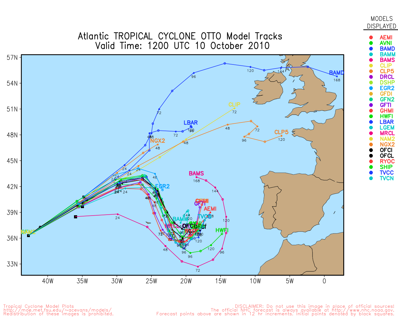
4:00 PM CDT Saturday, 9 October 2010 Update
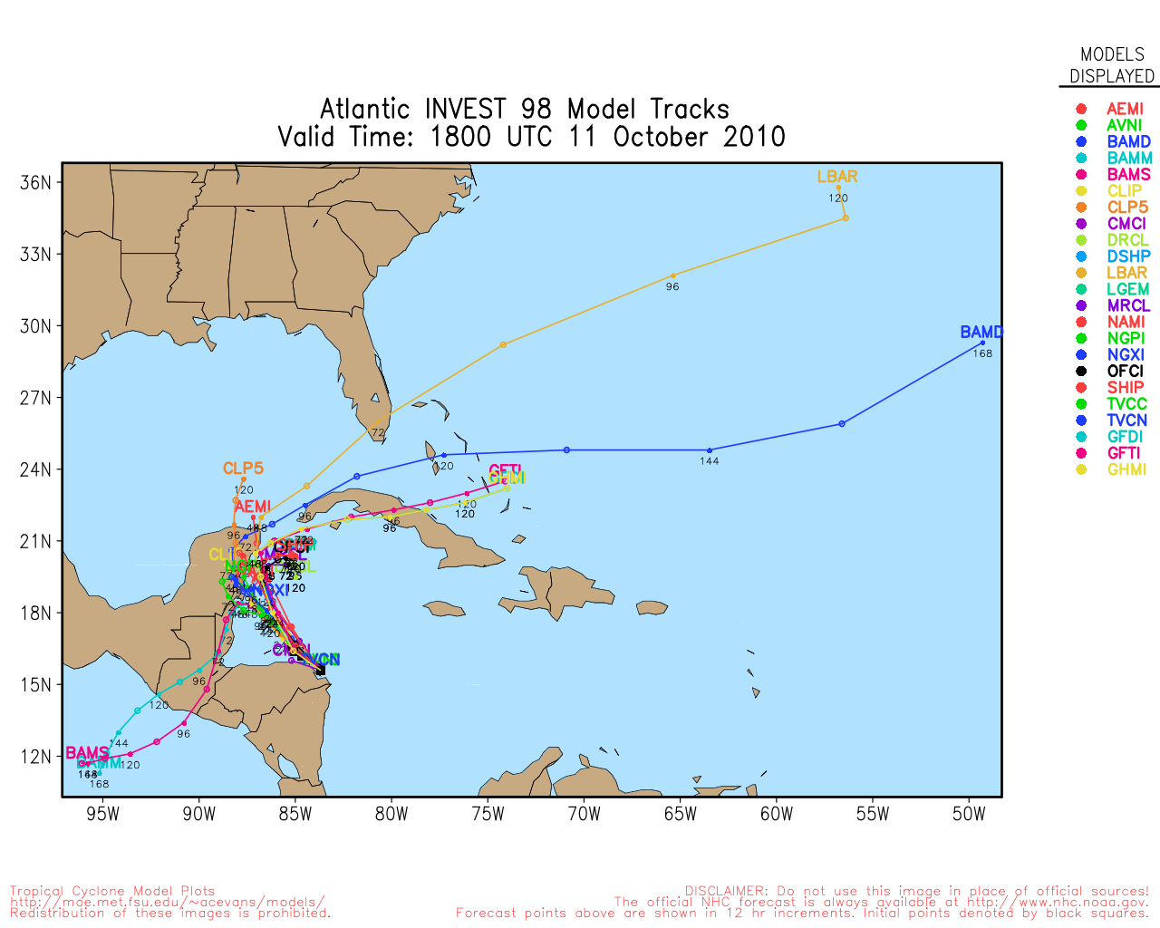
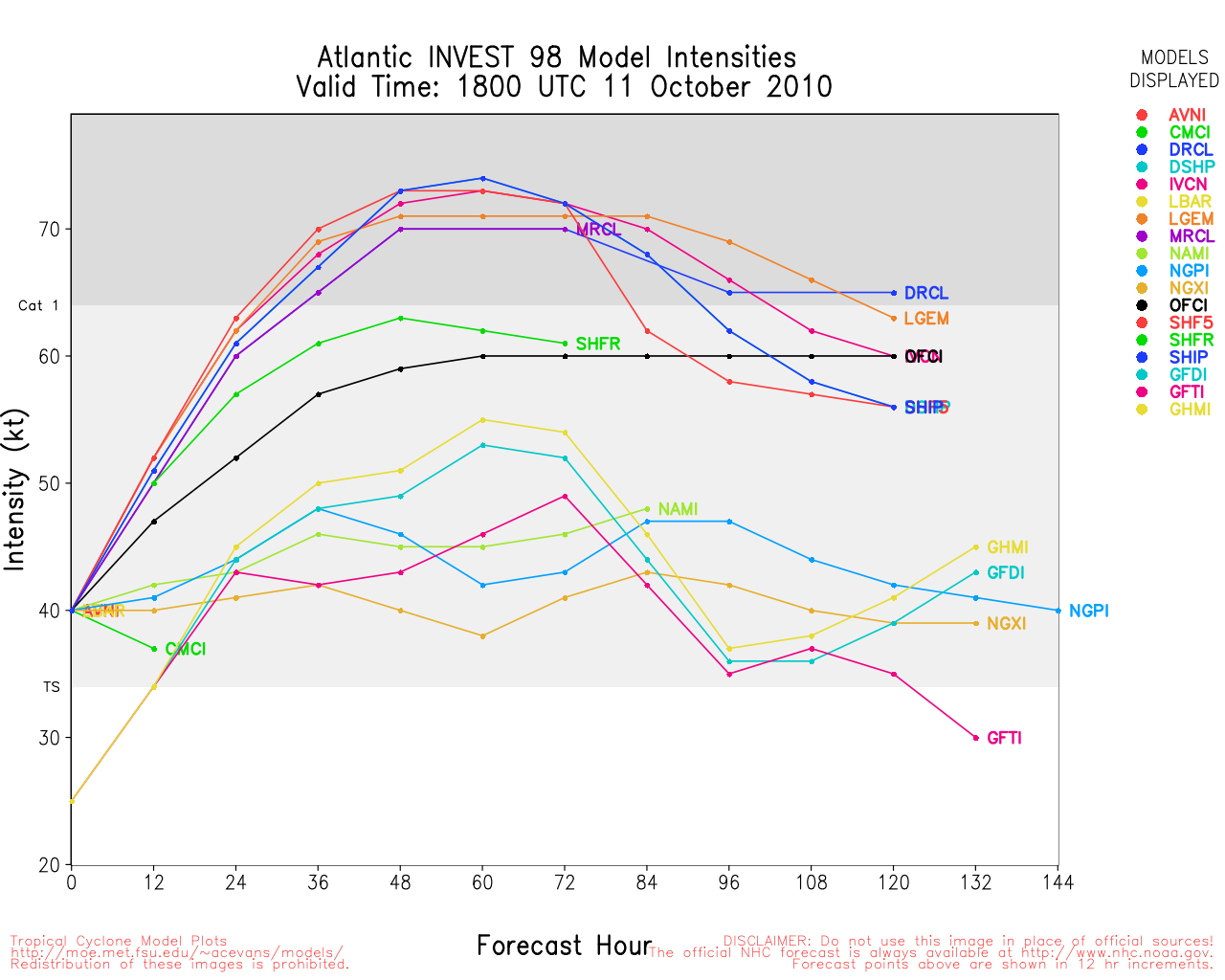
West Caribbean Invest 98L has been improving in structure quite a bit today, and a tropical cyclone could be forming this weekend. The National Hurricane Center earlier today put up a now seemingly conservative 30% probability of tropical cyclone formation within the next 48 hours ("Code Orange") for this disturbance.
Invest 98L consists of developing low and mid level centers, which appear to be fairly well colocated, in the vicinity of 13N and 80W. Some curved convective banding is noted in the western half of the disturbance, and back-of-the-envelope real-time Dvoark Current Intensity may already be close to T1.5 or better.
Sea surface temperatures in this region are still quite warm, and shear is not prohibitive. Indeed, shear looks to be easing while the atmosphere is also moistening up (all this being more conducive for further development). Movement seems to be net-net generally to the west, after some earlier center of circulation jumps and/or meanderings.
Interests from central America to the Yucatan peninsula, and possibly also from Cuba and into the GOM, may wish to be on the alert for the potential tropical cyclone formation, and any watches and warnings that may be issued for these areas, as at this early stage, it is very unclear which direction 98L will ultimately take. On one hand, interaction with central America could ultimately cut its development short. On the other, 98L could begin edging more to the northwest, or even to the north in time, and thus spend a good deal longer over water. Models should start having a better handle on its future track by this time tomorrow.
-Cieldumort
11:00 AM EDT Friday, 8 October 2010 Update
Otto has been upgraded to a Hurricane, and will likely remain so through the weekend, it's path takes it far away from any land areas. It is expected to transition to Monday and near the azores then.
The area in the west Caribbean still has about a 20% chance for development. It's best chance for development is probably late Monday, if it does at all. Those in western Cuba, Jamaica, and the Caymans will want to watch it the most. It isn't likely to affect the US.
StormCarib Reports from the Caribbean Islands
Caribbean Weather Observations
Barbados Brohav Weather Fax
Full Caribbean Radar Composite
Caribbean Broadcast Corporation (TV/Radio from Antilles)
San Juan, PR NWS Page
Various Caribbean Radio Stations
DR1 Dominican Republic Hurricanes
Otto Event Related Links


SFWMD Model Plot (Animated Model Plot) SFWMD Hurricane Page
[https://flhurricane.com/floatanimator.php?year=2010&storm=17 Flhurricane Satellite Floater Animation of Otto
GOES Floater
Animated Model Plot of Otto
Clark Evans Track Model Plot of Otto
(Animated!) Model Plots in Google Earth - In Google Maps
Clark Evans Intensity Model Plot of Otto (Animated!)
Clark Evans Track Plot of Otto
Other Model Charts from Clark
Clark Evans Top 10 Analog Storms for Otto
More model runs on from RAL/Jonathan Vigh's page
NRL Info on Otto -- RAMMB Info
COD Atlantic Satellite View
98L Event Related Links


SFWMD Model Plot (Animated Model Plot) SFWMD Hurricane Page
[https://flhurricane.com/floatanimator.php?year=2010&storm=18 Flhurricane Satellite Floater Animation of 98L
GOES Floater
Animated Model Plot of 98L
Clark Evans Track Model Plot of 98L
(Animated!) Model Plots in Google Earth - In Google Maps
Clark Evans Intensity Model Plot of 98L (Animated!)
Clark Evans Track Plot of 98L
Other Model Charts from Clark
Clark Evans Top 10 Analog Storms for 98L
More model runs on from RAL/Jonathan Vigh's page
NRL Info on 98L -- RAMMB Info
COD Atlantic Satellite View
8:00 AM EDT Wednesday, 6 October 2010 Update
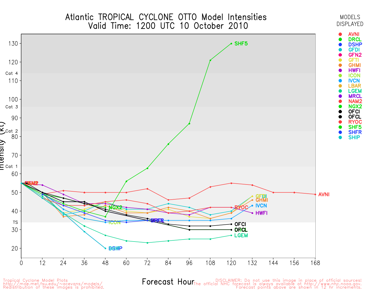
Otto continues to strengthen and has a shot at becoming a hurricane before hitting the worst of the shear, it will stay away from land until it becomes , where it may affect the Azores.
If Otto were to become a hurricane, it would likely be tonight or tomorrow, after which chances go down.
The area in the western Caribbean has a 10% chance to develop now, and it's most likely development period is Sunday or Monday.. If it does develop the most likely scenario is that it will slowly move into the Yucatan and rain. There is a slight chance it could get "picked up" by something further north that would bring it across Cuba, although most likely it will stay east of Florida, or most of the convection will anyway. It is what to watch over the weekend.
5:00 PM EDT Wednesday, 6 October 2010 Update
Subtropical Storm Otto forms.
Otto Event Related Links
SFWMD Model Plot (Animated Model Plot) SFWMD Hurricane Page
[https://flhurricane.com/floatanimator.php?year=2010&storm=17 Flhurricane Satellite Floater Animation of Otto
GOES Floater
Animated Model Plot of Otto
Clark Evans Track Model Plot of Otto
(Animated!) Model Plots in Google Earth - In Google Maps
Clark Evans Intensity Model Plot of Otto (Animated!)
Clark Evans Track Plot of Otto
Other Model Charts from Clark
Clark Evans Top 10 Analog Storms for Otto
More model runs on from RAL/Jonathan Vigh's page
NRL Info on Otto -- RAMMB Info
COD Atlantic Satellite View
7:00 AM EDT Wednesday, 6 October 2010 Update
Subtropical Depression 17 has formed northeast of the Caribbean, it is expected to drift slowly north and northwest for a bit then race out to sea to the northeast. This system will very likely be no threat to land.
Subtropical storms tend to hand stronger winds away from the center, but they still do have some tropical like characteristics near the center. This system has a good shot at becoming purely tropical before hitting the bump to the east. It won't likely be anything more than a mid wind-range Tropical storm.
The western Caribbean continues to be an area to watch for next week.
StormCarib Reports from the Caribbean Islands
Caribbean Weather Observations
Barbados Brohav Weather Fax
Full Caribbean Radar Composite
Caribbean Broadcast Corporation (TV/Radio from Antilles)
San Juan, PR NWS Page
Various Caribbean Radio Stations
DR1 Dominican Republic Hurricanes
6:30 AM EDT Tuesday, 5 October 2010 Update
Chances have risen for development of 97L, which peaks tomorrow, it is over the northeastern Caribbean sea bringing rainfall to the islands. It is still forecast to move away from the United States.
The western Caribbean may still have something in it next week, but the current pattern around the Gulf resembles more November than October this year, s
Original Update
So far the wave in the northeastern Caribbean (97L) has not developed, and conditions got worse for it as it approached the islands. It still has a chance to cause rainfall along the Caribbean islands, and still has a chance to develop, 20% now, but that improves later in the week. However any development is likely to recurve out to sea before it reaches the continental United States.
Another wave east of the Caribbean currently isn't being tracked as an invest area, but only has a 10% chance for development.
Activity from The west Caribbean won't likely be seen until next week.
Edited by cieldumort (Sat Oct 09 2010 05:24 PM)
|
MichaelA
Weather Analyst

Reged: Thu
Posts: 945
Loc: Pinellas Park, FL
|
|
There wasn't much change there all day. Things should be winding down now anyway. As the fronts come down and stall over the Gulf of Mexico and the Western Caribbean, those will become the areas to keep an eye on.
Update 10/5: It looks like 97L is being severely sheared to me this morning along with a considerable amount of dry air being pulled in on the western side. I'm thinking that 60% is a bit high for development there. That new blob of convection in the Caribbean might gain some traction later in the week.
--------------------
Michael
PWS
Edited by MichaelA (Tue Oct 05 2010 08:37 AM)
|
IsoFlame
Weather Analyst

Reged: Wed
Posts: 295
Loc: One block off the Atlantic Oce...
|
|
Yep, 97L not fairing well given shear. Area of convection in the Bahamas to the east of Miami (not an invest ATM), associated with the front that pushed through Florida and pulled up stationary will likely have same fate given the flow.
What about the area of convection in the Caribbean south of Hispanola this morning? Not an invest ATM, but this is a region where I'd expect some development if it persists.
--------------------
CoCoRaHS Weather Observer (FL-VL-42) & Surf Forecaster: https://www.surf-station.com/north-florida-surf-forecast-3/
|
weathernet
Storm Tracker
Reged: Sat
Posts: 296
Loc: Elsewhere
|
|
97L looking like it's trying to develop, albeit sub-tropical in appearance. Even so, could easily shake it off and become entirely tropical. Outside of the dangerous flooding potential for P.R. and Lesser Antilles, seems like only possibly of risk might be to a few thousand snapper, yellow tail, and the like.
As previously mentioned, the area south of Eastern Haiti is not only very convective, but would appear to possibly be showing hints of some rotation ( at some level ). The upper level winds are no doubt seemingly beginning to relent, and actually a good deal less hostile than what 97L is currently dealing with.
|
MichaelA
Weather Analyst
Reged: Thu
Posts: 945
Loc: Pinellas Park, FL
|
|
I agree that 97L looks to be more subtropical in organization. A lot of dry air entrainment from the western side and still a significant amount of shear. If it develops, I would think that it would be subtropical rather than purely tropical. The models are developing 97L and moving it northeastward and they are indicating something forming in the western Caribbean late in the period 5 - 7 days from now.
--------------------
Michael
PWS
|
IsoFlame
Weather Analyst
Reged: Wed
Posts: 295
Loc: One block off the Atlantic Oce...
|
|
Supportive SST's still lingering ITVO the Florida peninsula... I recorded a surf water temperature of 81.2F in south NSB Sunday afternoon. Looks like SST's near the convective complex in the Caribbean are just below seasonal peaks: buoy # 42059 reporting 85.3F this afternoon with a baro of 29.77". Note the moderate to strong/increasing west wind past 12 hours.
--------------------
CoCoRaHS Weather Observer (FL-VL-42) & Surf Forecaster: https://www.surf-station.com/north-florida-surf-forecast-3/
|
weathernet
Storm Tracker
Reged: Sat
Posts: 296
Loc: Elsewhere
|
|
Sounds like perhaps a weak LLC may be attempting to organize south of Hispanola. Perhaps we have 97L and 97L"b" competing for inflow here. This afternoons satellite indicates that the Cirrus blow off in the central Caribbean sure looks to be light and almost variable.
|
berrywr
Weather Analyst

Reged: Fri
Posts: 387
Loc: Opelika, AL
|
|
However this system evolves it won't be tropical to start. An approach to the US is zero; winds aloft are well over 80 knots at the core...that takes care of that scenario. There is an upper high above the system itself so winds are light right over the top and marginal along the projected track. It looks pretty on satellite but that's it.
--------------------
Sincerely,
Bill Berry
"Survived Trigonometry and Calculus I"
|
vineyardsaker
Weather Guru

Reged: Wed
Posts: 150
Loc: New Smyrna Beach, FL
|
|
sorry for the primitive question, but what exactly differentiates a tropical and a subtropical system (in layman's terms, please)?
thanks!
Edited by vineyardsaker (Wed Oct 06 2010 12:00 PM)
|
danielw
Moderator

Reged: Wed
Posts: 3525
Loc: Hattiesburg,MS (31.3N 89.3W)
|
|
Tropical depression/ storm is typically warm core with highest winds near the center.
Subtropical depression/ storm is typically cold core with highest winds located away from the center.
That is the way that I define them. I am sure that someone has a better explanation.
Edited by danielw (Wed Oct 06 2010 01:44 PM)
|
Bloodstar
Moderator

Reged: Mon
Posts: 462
Loc: Tucson, AZ
|
|
Looks like we Have Otto at 5PM, Not much else has changed, Recon is finding pressures around 991 or so. And I don't think there is any reason to expect the track to change. Sub-Tropical systems aren't terribly common, so it's interesting to see the structural differences between it and a fully tropical system.
--------------------
M. S. Earth and Atmospheric Sciences, Georgia Tech - May 2020
Brookhaven National Laboratory
U. Arizona PhD Student
|
weathernet
Storm Tracker
Reged: Sat
Posts: 296
Loc: Elsewhere
|
|
One thing for sure, though sub-tropical in nature and with the enormous feed from the Pacific , I would have little doubt that given time we'd see an eventual crossover to fully tropical. Entirely academic however and the good news is that it's simply waiting for it's "train pass" from the short wave railway to the N. Atlantic.
|
danielw
Moderator
Reged: Wed
Posts: 3525
Loc: Hattiesburg,MS (31.3N 89.3W)
|
|
Otto appears to be changing to a Tropical Storm and a warm core system, based on the latest satellite imagery.

Other area to watch is the Western Caribbean. No mention of this system in any of the current forecast discussions.
Grand Cayman is the small island in the top of the frame.

Edited by danielw (Thu Oct 07 2010 12:01 PM)
|
WeatherNut
Weather Master
Reged: Wed
Posts: 412
Loc: Atlanta, GA
|
|
Otto is a hurricane as of 11am adv.
--------------------
Born into Cleo (64)...been stuck on em ever since
|
M.A.
Weather Guru
Reged: Thu
Posts: 108
Loc: Vero Beach, Fl
|
|
There seems to be a LLC or MLC forming just north of Panama. Convection is not looking to impressive at the moment. Being October and climatalogically prime for this area of the Caribbean, keeping an eye on it.
|
M.A.
Weather Guru
Reged: Thu
Posts: 108
Loc: Vero Beach, Fl
|
|
Convection is building in the area north of Panama. Definate circulation. Very suprised this is not atleast an invest. on vacation?
|
Owlguin
Weather Hobbyist
Reged: Thu
Posts: 68
|
|
It is - 98L. Impressive visible loop.
|
WesnWylie
Weather Guru
Reged: Sat
Posts: 155
Loc:
|
|
I think we will have Tropical Depression 18 very soon because it is organizing pretty quickly. By the way, it has been Invest 98L since yesterday evening. That is when the initial model runs began on this disturbance.
--------------------
2011 Season Forecast: 16/09/04
2011 Systems: 10/01/01
|
danielw
Moderator
Reged: Wed
Posts: 3525
Loc: Hattiesburg,MS (31.3N 89.3W)
|
|
Recent satellite imagery is indicating a decrease in the convection in the western band and a CHT, convective hot tower, developing to the NE of the CoC.
Almost appeared to be a shift in power... drawing energy from the western convective band and building the CHT near the center.
Current CoC near 13.0N/ 81.0W, using the wv loop. Or about 45 miles ENE of San Andreas Island.
Current CHT near 13.2N/ 80.4W
ICAO : SKSP
Station Name : San Andres Island
Country : Colombia
Location : 12.57N 81.72W
Time : 9 / 22:00Z
Temperature : 77.0
Dew Point : 75.2
RH : 94
Heat Index : 77.9
Wind : N (360) at 9 mph
Visibility : 3.7 miles
Pressure : 1008.8
Sky Condition : Scattered clouds at 1200ft, Broken clouds at 7000ft
Weather : Drizzle
Wind Chill : N/A
Remarks :
METAR : SKSP 092200Z 36008KT 6000 DZ SCT012 BKN070 25/24 A2979 RMK WSRWY06
System seems to be elongated from SSW to NNE.
Latest 98L surface plot from Coolwx.com
Buoy 42057 is 232nm NNW of the CoC and is reporting continuous increases in wind speed over the last hour. With 5 degree drop in air temperature... raining.
http://www.ndbc.noaa.gov/station_page.php?station=42057
Station 42057
NDBC
Location: 16.834N 81.501W
Conditions as of:
Sat, 9 Oct 2010 21:50:00 UTC
Winds: NNE (30°) at 25.3 kt gusting to 29.1 kt
Significant Wave Height: 5.6 ft
Dominant Wave Period: 7 sec
Atmospheric Pressure: 29.84 in and falling
Air Temperature: 78.1 F
Dew Point: 74.7 F
Water Temperature: 84.2 F
Edited by danielw (Sat Oct 09 2010 06:45 PM)
|
CaneTrackerInSoFl
Storm Tracker

Reged: Mon
Posts: 395
Loc: Israel
|
|
I wonder what the is waiting on on 98L. It seems to have a very vigorous vorticity and it appears to be consolidating quite nicely as it moves between the wnw and nw.
Certainly think if it keeps up this trend, we'll have a depression by tomorrow.
--------------------
Andrew 1992, Irene 1999, Katrina 2005, Wilma 2005
|


 Threaded


