MikeC
Admin
Reged:
Posts: 4544
Loc: Orlando, FL
|
|
Friday November 5, 2010 7AM EDT Update
Tomas is approaching Haiti with the "dirty" side of the storm, and overnight it restrengthened into a hurricane. The worst from the system will be felt in Haiti all day today. Once the system moves past Haiti in about 24 hours, it will run into the trough which will likely shear it apart rather quickly.

But in the meantime, that means Haiti, in no condition to do so, will have to deal with a strengthening hurricane raking along the western shore. It likely won't begin weakening soon enough to prevent hurricane conditions around the Turks and Caicos either, so those in that area should also prepare for as high as category 3 conditions. The closest approach for the Turks and Caicos is pre-dawn tomorrow.
[Jamaican Radar
Thursday November 4, 2010 7AM EDT Update
Tropical Storm Tomas is approaching the central Caribbean and may near Jamaica, enough so that a Tropical Storm warning remains up. Because a hurricane is once again forecast later, Hurricane Warnings are up for Haiti, and the Turks and Caicos Islands along the Eastern Bahamas. After which Tomas should stay out to sea.
The area likely to be hardest hit by Tomas is in Western Haiti, where the combination of rain and wind will likely cause numerous mudslides.
Conditions in eastern Jamaica may deteriorate to Tropical Storm conditions late this afternoon into the evening. Possibly Hurricane conditions likely will be in Haiti very late tonight into tomorrow morning, and in the Turks and Caicos midday Friday through the afternoon.
Wednesday November 3, 2010 6PM EDT Update
Tomas is back to Tropical Storm strength, and is now forecast to stay that way as it moves generally north northwest. Tropical storm watches are up for Jamaica, the far Eastern Bahamas. A tropical storm warning is up for Haiti. A Hurricane watch is also up for Haiti.
Wednesday November 3, 2010 Noon EDT Update
Tomas, expected to possibly become a major hurricane a few days ago, instead has now become a depression in the Central Caribbean. However, the official forecast still takes it back to tropical storm strength before a landfall on Haiti on Friday.
Weakening looks to be caused by mid and upper level shear, even with other factors being positive.
Since Jamaica is in the cone, they have issued a hurricane watch, but it appears the system will stay east of the island, but there is a fairly good chance it may get close enough to see some tropical storm conditions along eastern sections of the island.
One past Haiti it is expected to curve further north and east away from the Bahamas and stay out to sea.
Monday November 1, 2010 1:00PM EDT Update
Earlier today southwesterly windshear had reduced Tomas to a low level swirl that was displaced from its convection by over 100 miles. In the last few hours the convection has developed into the center from the northeast and this should maintain tropical storm status for Tomas and suggests that the windshear has started to relax.
One of the dangers of a 12-hour averaging for motion is that a more imminent threat can arise rather quickly. While the concern has centered on Haiti in the long range, Tomas has had a more recent short-term motion to the southwest toward Aruba. If the convective trend and the short-term motion trend continue, and right now both of those prospects represent a big 'IF', the folks in Aruba could become unexpected targets of tropical storm conditions. The motion to the southwest could be just a short term anomaly and with convection again developing at the center the track could readjust to the west.
ED
Curacao Radar Loop
Monday November 1, 2010 7:00AM EDT Update
Tomas is undergoing rather strong vertical shear which has left the system decoupled, and has greatly weakened the system, which is good news somewhat since it makes it unlikely to reach a major hurricane, but it still is forecast to become a hurricane again before landfall in Haiti, unfortunately.
Any tropical system of any strength is dangerous for Haiti in the condition that the nation is in now. Mostly from rain and mudslides, wind is just another issue on top of that.
Other areas in the cone need to continue to watch Tomas, including Jamaica.
Sunday October 31, 2010 9:0AM EDT Update
Tomas has strengthened to a category 2 hurricane this morning, and is moving generally toward the west northwest. There is quite a bit of uncertainty a few days out, but the news is not good for Haiti, who has the highest chance of seeing a possible direct landfall from a major hurricane Thursday-Friday being the most likely time frame..
The uncertainty of the models also suggest Jamaica, Dominican Republic, and Puerto Rico will have to continue to monitor the storm for changes.
Any type of land falling storm has the potential to be disastrous for Haiti, a major would re-devastate areas affected by the earthquake from January.
French Antilles Radar Recording of Tomas Approach (Flhurricane)
Saturday October 30, 2010 11:45PM EDT Update
After hitting St. Vincent and St. Lucia with winds of 90mph, Hurricane Tomas is moving slowly west northwest into the eastern Caribbean Sea. Additional slow intensification is possible on Sunday and Monday as Tomas continues the slow movement to the west northwest on Sunday and more westerly on Monday. Portions of the Leeward Islands are still experiencing tropical storm force winds but these winds should eventually abate as Tomas continues to move further west.
Tropical Storm Shary has started to interact with a strong cold front in the north central Atlantic. With transition underway, issued its last advisory on Shary at 30/21Z.
ED
Saturday October 30, 2010 1:30AM EDT Update
Hurricane Warnings are now up for a growing portion of the Windward Islands, including, but not limited to, Barbados and the Grenadines, with the center of Tomas forecast to pass near Barbados in just a few hours.
Tomas has been undergoing some RI, or Rapid Intensification, tonight, and maximum sustained winds were most recently estimated to be up to 65MPH. Further intensification overnight looks very possible, and obviously Tomas could even become a formidable hurricane at just about any time now.
In addition to high wind, Tomas is an especially large, moisture-laden tropical cyclone, and so flooding is also already a concern.
2010 continues setting new records with the formation of Tomas on Friday:
On Friday, Tomas set the new record, in our admittedly limited data base, for tropical storm formation so far south and east this late in a season.
One actually has to go all the way back to 1896 to find a lone challenger, when "Hurricane Six" was estimated to have first become a Tropical Storm on October 26, also south of 12N and east of 60W, but remain so only up to about nine hours earlier than Tomas, up to the very early morning of October 29 of that year, after which "Six," by now also a strong Category 1 Hurricane, had already started recurving out to sea, and breached 12N as of about 06Z October 29, 1896. (LINK)
With the formation of Tomas, 2010 now ties the hyperactive years, 1995 & 1887, for 3rd place for most named storms in the Atlantic basin, bested only by 1933, at 21 names, and of course 2005, with 28.
- Ciel
Original Entry
The nineteenth named storm of the 2010 season has formed east of the Caribbean. It has a good overall pattern and outflow which could set it up for possible rapid intensification when or if it gets vertically aligned. Those in the path will want to watch in closely.
In fact, Tropical Storm Warnings are now up for Barbados, Martinique, St. Lucia, St. Vincent, Grenada, Trinidad, and Tobago.
A tropical storm watch is also up for Dominica.

The system is forecast to become a hurricane, and then a major hurricane in the Central Caribbean. Jamaica, Haiti, and the Eastern side of Cuba will want to watch closely. When it arrives in the Central Caribbean, steering currents relax and it should slow down forward movement.
At that time it gets a bit hairy and depends on if it gets picked up by the next progressive mid-latitude system, or not. Currently, it seems slightly more likely for it to eventually turn north and then get kicked east and out, which unfortunately puts several land masses at risk in the Caribbean. Another possibility is that it slips west, and another ridge forms, bringing yet more risk to the Caymans, and Central America (again). Both are equally possible at present. It seems highly unlikely that the system gets close enough to directly affect the US mainland or get in the Gulf.
More to come later...
Edited by cieldumort (Sat Nov 06 2010 06:04 AM)
|
MichaelA
Weather Analyst

Reged:
Posts: 944
Loc: Pinellas Park, FL
|
|
8 PM ET:
Quote:
BULLETIN
TROPICAL STORM TOMAS SPECIAL ADVISORY NUMBER 2
NWS TPC/NATIONAL HURRICANE CENTER MIAMI FL AL212010
800 PM AST FRI OCT 29 2010
...TOMAS STRENGTHENING QUICKLY EAST OF THE WINDWARD ISLANDS...
SUMMARY OF 800 PM AST...0000 UTC...INFORMATION
----------------------------------------------
LOCATION...11.6N 57.6W
ABOUT 170 MI...270 KM SE OF BARBADOS
ABOUT 270 MI...435 KM ESE OF ST. VINCENT
MAXIMUM SUSTAINED WINDS...60 MPH...95 KM/HR
PRESENT MOVEMENT...WNW OR 300 DEGREES AT 15 MPH...24 KM/HR
MINIMUM CENTRAL PRESSURE...999 MB...29.50 INCHES
The discussion is also enlightening.
Tomas is gaining strength faster than anticipated which will influence the immediate future forecasts and model runs. As has been stated, Tomas has the potential to be a record breaker.
EDIT: It appears that the center of Tomas will be passing very near Barbados over night.
Edited by MichaelA (Sat Oct 30 2010 01:40 AM)
|
Ed Dunham
Former Meteorologist & CFHC Forum Moderator (Ed Passed Away on May 14, 2017)
Reged:
Posts: 2565
Loc: Melbourne, FL
|
|
Surface observations suggest that Tomas passed just south of Barbados just before 30/10Z. Lowest pressure at Barbados was 996MB. Tomas appears to be moving more consistently now toward the west northwest and should pass just south of St. Lucia later this Saturday morning. Satellite imagery suggests that the southern quadrant of the storm is still a bit disorganized.
ED
|
danielw
Moderator

Reged:
Posts: 3525
Loc: Hattiesburg,MS (31.3N 89.3W)
|
|
RECON is about 90 miles NW o the center and reporting 50 kt winds at 10,000 feet.
ED has previously commented on the surface observations. 
Latest observation, below. Tomas' wind center about 21 miles SSW of the airport.
ICAO TBPB
Station Name Grantley Adams
Country Barbados
Location 13.07N 59.48W
Time 30 / 11:00Z
Temperature 77.0
Dew Point 77.0
RH 100 %
Heat Index 77.5
Wind S (180) at 35, 56 gusts mph
Wind Chill N/A
Visibility 0.3 mi
Pressure 1001.0 mb
Sky Condition Broken Cumulonimbus clouds at 800ft
Broken clouds at 1000ft
Weather Rain
Remarks
METAR TBPB 301100Z 18030G49KT 0500 RA BKN008CB BKN010 25/25 Q1001 NOSIG
Edited by danielw (Sat Oct 30 2010 11:06 AM)
|
danielw
Moderator
Reged:
Posts: 3525
Loc: Hattiesburg,MS (31.3N 89.3W)
|
|
RECON reporting a 30 mile by 50 mile elliptical Eye.
Product: Air Force Vortex Message (URNT12 KNHC)
Transmitted: 30th day of the month at 11:30Z
Aircraft: Air Force Aircraft (Last 3 digits of the tail number are 300)
Storm Number & Year: 21L in 2010
Storm Name: Tomas (flight in the North Atlantic basin)
Mission Number: 2
Observation Number: 04
A. Time of Center Fix: 30th day of the month at 10:47:40Z
B. Center Fix Coordinates: 12°59'N 59°52'W (12.9833N 59.8667W)
B. Center Fix Location: 19 miles (30 km) to the WSW (246°) from Bridgetown, Barbados.
C. Minimum Height at Standard Level: 3,033m (9,951ft) at 700mb
D. Estimated (by SFMR or visually) Maximum Surface Wind: 51kts (~ 58.7mph)
E. Location of the Estimated Maximum Surface Wind: 23 nautical miles (26 statute miles) to the WNW (298°) of center fix
F. Maximum Flight Level Wind Inbound: From 20° at 52kts (From the NNE at ~ 59.8mph)
G. Location of Maximum Flight Level Wind Inbound: 57 nautical miles (66 statute miles) to the WNW (301°) of center fix
H. Minimum Sea Level Pressure: 993mb (29.32 inHg) - Extrapolated
I. Maximum Flight Level Temp & Pressure Altitude Outside Eye: 10°C (50°F) at a pressure alt. of 3,043m (9,984ft)
J. Maximum Flight Level Temp & Pressure Altitude Inside Eye: 13°C (55°F) at a pressure alt. of 3,046m (9,993ft)
K. Dewpoint Temp (collected at same location as temp inside eye): 1°C (34°F)
K. Sea Surface Temp (collected at same location as temp inside eye): Not Available
L. Eye Character (Undecoded): SPIRAL EYEWALL
M. Eye Shape: Elliptical (oval shaped)
M. Orientation of Major Axis in Elliptical Eye: 360° to 180° (N to S)
M. Length of Major Axis in Elliptical Eye: 50 nautical miles (58 statute miles)
M. Length of Minor Axis in Elliptical Eye: 30 nautical miles (35 statute miles)
N. Fix Determined By: Penetration, Radar, Wind, Pressure and Temperature
N. Fix Level: 700mb
O. Navigation Fix Accuracy: 0.02 nautical miles
O. Meteorological Accuracy: 1 nautical mile
Remarks Section - Remarks That Were Decoded...
Maximum Flight Level Wind: 52kts (~ 59.8mph) in the northwest quadrant at 10:31:30Z
Remarks Section - Additional Remarks...
SLP EXTRAP FROM DROPSONDE
SEVERAL SPIRAL BANDS WRAPPING IN TO CTR FROM NORTH
edit: As of 8:11 AM EDT Tropical Storm Tomas is very near Hurricane strength. RECON is currently flying the eastern side of the storm and will be making the turn inbound to fly the remainder of the NE Quadrant shortly.
Edited by danielw (Sat Oct 30 2010 12:14 PM)
|
danielw
Moderator
Reged:
Posts: 3525
Loc: Hattiesburg,MS (31.3N 89.3W)
|
|
AT 800 AM AST...1200 UTC...THE CENTER OF TROPICAL STORM TOMAS WAS
LOCATED NEAR LATITUDE 13.1 NORTH...LONGITUDE 60.1 WEST. TOMAS IS
MOVING TOWARD THE WEST-NORTHWEST NEAR 15 MPH...24 KM/HR...AND THIS
MOTION IS EXPECTED TO CONTINUE WITH A GRADUAL DECREASE IN FORWARD
SPEED TONIGHT AND SUNDAY. ON THE FORECAST TRACK...THE CENTER OF
TOMAS WILL PASS THROUGH THE NORTHERN WINDWARD ISLANDS THIS AFTERNOON
AND ENTER THE EASTERN CARIBBEAN SEA BY TONIGHT.
MAXIMUM SUSTAINED WINDS HAVE ARE NEAR 70 MPH...110 KM/HR...
WITH HIGHER GUSTS. STRENGTHENING IS FORECAST DURING THE NEXT 48
HOURS...AND TOMAS IS EXPECTED TO BECOME A HURRICANE LATER TODAY.
TROPICAL STORM FORCE WINDS EXTEND OUTWARD UP TO 140 MILES...220 KM
FROM THE CENTER. DURING THE PAST HOUR...A WIND GUST TO 63 MPH...100
KM/HR...WAS REPORTED ON BARBADOS. INFORMATION FROM THE BARBADOS
METEOROLOGICAL SERVICE INDICATES THAT DAMAGE TO HOMES AND DOWNED
POWER LINES HAVE BEEN REPORTED ON THE ISLAND.
THE MINIMUM CENTRAL PRESSURE RECENTLY ESTIMATED BY AN AIR FORCE
RESERVE RECONNAISSANCE AIRCRAFT WAS 993 MB...29.32 INCHES.
|
danielw
Moderator
Reged:
Posts: 3525
Loc: Hattiesburg,MS (31.3N 89.3W)
|
|
HURRICANE TOMAS DISCUSSION NUMBER 5
NWS TPC/NATIONAL HURRICANE CENTER MIAMI FL AL212010
1100 AM AST SAT OCT 30 2010
AN AIR FORCE RESERVE HURRICANE HUNTER AIRCRAFT INVESTIGATING TOMAS
THIS MORNING FOUND MAXIMUM 700 MB FLIGHT-LEVEL WINDS OF 68 KT IN
THE SOUTHEAST QUADRANT ALONG WITH SEVERAL 64-66 KT RELIABLE SFMR
WINDS. IN ADDITION...A DROPSONDE IN THE NORTHEAST EYEWALL INDICATED
A SURFACE WIND OF 72 KT. HOWEVER...THE BOUNDARY-LAYER WIND PROFILES
SUGGEST A SLIGHTLY LESSER SURFACE WIND SPEED ESTIMATE OF AROUND 66
KT. A COMBINATION OF THIS DATA EASILY SUPPORTS A 65-KT HURRICANE...
AND TOMAS HAS BEEN UPGRADED ACCORDINGLY.
|
danielw
Moderator
Reged:
Posts: 3525
Loc: Hattiesburg,MS (31.3N 89.3W)
|
|
Current weather from St Lucia.
ICAO TLPL
Station Name Hewanorra Intl
Country Saint Lucia
Location 13.75N 60.95W
Time 30 / 16:00Z
Temperature 73.4
Dew Point 73.4
RH 100 %
Heat Index 68.4
Wind NE (50) at 48, 69 gusts mph
Wind Chill N/A
Visibility 0.6 mi
Pressure 1005.1 mb
Sky Condition Few clouds at 600ft
Scattered Cumulonimbus clouds at 1200ft
Broken clouds at 1400ft
Overcast at 6000ft
Weather Heavy Rain
Remarks
METAR TLPL 301600Z 05042G60KT 1000 +RA FEW006 SCT012CB BKN014 OVC060 23/23 Q1005
|
danielw
Moderator
Reged:
Posts: 3525
Loc: Hattiesburg,MS (31.3N 89.3W)
|
|
HURRICANE TOMAS DISCUSSION NUMBER 6
NWS TPC/NATIONAL HURRICANE CENTER MIAMI FL AL212010
500 PM AST SAT OCT 30 2010
AN AIR FORCE RESERVE HURRICANE HUNTER AIRCRAFT INVESTIGATING TOMAS
THIS AFTERNOON FOUND MAXIMUM 700 MB FLIGHT-LEVEL WINDS OF 67 KT IN
THE NORTH QUADRANT...WHICH EQUATES TO ABOUT 60 KT SURFACE WINDS.
SATELLITE INTENSITY ESTIMATES ARE A CONSENSUS T4.0/65 KT FROM
AND SAB. THE STRUCTURE OF TOMAS HAS IMPROVED CONSIDERABLY IN RADAR
IMAGERY FROM MARTINIQUE...AND THE CYCLONE NOW POSSESSES A CLOSED 25
N MI DIAMETER EYE. THE INTENSITY IS BEING HELD AT 65 KT FOR THIS
ADVISORY...WHICH COULD BE A LITTLE LOW BASED ON SOME OF THE DAMAGE
REPORTS THAT HAVE BEEN RECEIVED FROM HAM RADIO OPERATORS ON ST.
LUCIA AND ST. VINCENT.
|
MichaelA
Weather Analyst
Reged:
Posts: 944
Loc: Pinellas Park, FL
|
|
Tomas is looking impressive on the French Antilles radar and on the last vis sat pic - closed eye on the radar and a on the sat pic. Seems to have a pretty symmetrical outflow as well. Interesting little jog between St. Vincent and St. Lucia as the center interacted with the islands.
EDIT: A Bulletin was posted at 6 PM AST stating that top winds are now 90 MPH.
--------------------
Michael
PWS
Edited by MichaelA (Sat Oct 30 2010 10:21 PM)
|
danielw
Moderator
Reged:
Posts: 3525
Loc: Hattiesburg,MS (31.3N 89.3W)
|
|
Here the upgrade.
HURRICANE TOMAS SPECIAL DISCUSSION NUMBER 7
NWS TPC/NATIONAL HURRICANE CENTER MIAMI FL AL212010
600 PM AST SAT OCT 30 2010
REPORTS FROM THE METEOROLOGICAL SERVICE OF ST. LUCIA INDICATE THAT
TOMAS HAS STRENGTHENED...WITH MAXIMUM WINDS OF 80 KT. THIS SPECIAL
ADVISORY IS ISSUED TO INCREASE THE INITIAL AND FORECAST INTENSITY
OF THE HURRICANE. NO OTHER CHANGES TO THE FORECAST HAVE BEEN MADE.
ESTIMATED MINIMUM CENTRAL PRESSURE IS 982 MB...29.00 INCHES.
Edited by danielw (Sat Oct 30 2010 10:34 PM)
|
Old Sailor
Storm Tracker

Reged:
Posts: 293
Loc: Florida
|
|
TOMAS should be at 40MPH at 5PM right now it's a TD but HC will wait to see what happens None of the models have had a good handle on Tomas The model seems to be the closest.
|
danielw
Moderator
Reged:
Posts: 3525
Loc: Hattiesburg,MS (31.3N 89.3W)
|
|
RECON has, for the most part, closed off a LOW. More of an east to west polygon. Winds at flight level were measured at speeds up to 51 mph along the east side of the polygon.
Coordinates: 14.95N 73.9W
Flt. Lvl. Wind (30s): From 147° at 47 knots (From the SSE at ~ 54.0 mph)
Acft. Geopotential Hgt: 264 meters (~ 866 feet)
NHC could upgrade Tomas back to Tropical Storm status at the 5 PM EDT Advisory. Stay tuned.
Edited by danielw (Wed Nov 03 2010 07:42 PM)
|
Ed in Va
Weather Master
Reged:
Posts: 489
Loc:
|
|
Back to TS at 5...discussion pending.
--------------------
Survived Carol and Edna '54 in Maine. Guess this kind of dates me!
|
danielw
Moderator
Reged:
Posts: 3525
Loc: Hattiesburg,MS (31.3N 89.3W)
|
|
TROPICAL STORM TOMAS DISCUSSION NUMBER 23
NWS TPC/NATIONAL HURRICANE CENTER MIAMI FL AL212010
500 PM EDT WED NOV 03 2010
AFTER STRUGGLING TO MAINTAIN ITS IDENTITY THIS MORNING...TOMAS HAS
RE-ORGANIZED DURING THE AFTERNOON. AN AIR FORCE RESERVE HURRICANE
HUNTER AIRCRAFT HAS FOUND A BETTER-DEFINED CIRCULATION THAN WAS
PRESENT DURING THE PREVIOUS AIRCRAFT MISSION...ALTHOUGH THE LIGHT
AND VARIABLE WIND CENTER IS STILL RATHER LARGE. THE PLANE FOUND
FLIGHT-LEVEL WINDS OF 48 KT BELOW 1500 FT AND ESTIMATED SURFACE
WINDS NEAR 40 KT FROM THE SFMR ABOUT 45 N MI EAST OF THE MEAN
CENTER. THE MINIMUM CENTRAL PRESSURE WAS 1003 MB. BASED ON THESE
DATA...TOMAS IS UPGRADED TO A 40-KT TROPICAL STORM.
|
MichaelA
Weather Analyst
Reged:
Posts: 944
Loc: Pinellas Park, FL
|
|
The 8 PM advisory has the center at 15N; 74.9W. It looks like it is nearer 15.2N; 74.7W to me on the JSL Color IR Floater Loop (also the other IR Floater Loops), but Tomas is moving NNW.
--------------------
Michael
PWS
|
danielw
Moderator
Reged:
Posts: 3525
Loc: Hattiesburg,MS (31.3N 89.3W)
|
|
DISCUSSION AND 48-HOUR OUTLOOK
------------------------------
AT 800 AM EDT...1500 UTC...THE CENTER OF TROPICAL STORM TOMAS WAS
LOCATED NEAR LATITUDE 15.9 NORTH...LONGITUDE 76.0 WEST. TOMAS IS
MOVING TOWARD THE NORTH-NORTHWEST NEAR 6 MPH...10 KM/HR. A TURN
TOWARD THE NORTH AND NORTHEAST WITH SOME INCREASE IN FORWARD SPEED
IS EXPECTED OVER THE NEXT 48 HOURS. ON THE FORECAST TRACK THE
CENTER WILL PASS NEAR HAITI OR EXTREME EASTERN CUBA TONIGHT AND
EARLY FRIDAY AND NEAR OR OVER THE SOUTHEASTERN BAHAMAS ON FRIDAY.
MAXIMUM SUSTAINED WINDS ARE NEAR 50 MPH...85 KM/HR...WITH HIGHER
GUSTS. SOME STRENGTHENING IS FORECAST DURING THE NEXT 48 HOURS.
TROPICAL-STORM-FORCE WINDS EXTEND OUTWARD UP TO 115 MILES...185 KM
FROM THE CENTER.
AN AIR FORCE HURRICANE HUNTER PLANE JUST REPORTED A MINIMUM
CENTRAL PRESSURE OF 998 MB...29.47 INCHES.
|
danielw
Moderator
Reged:
Posts: 3525
Loc: Hattiesburg,MS (31.3N 89.3W)
|
|
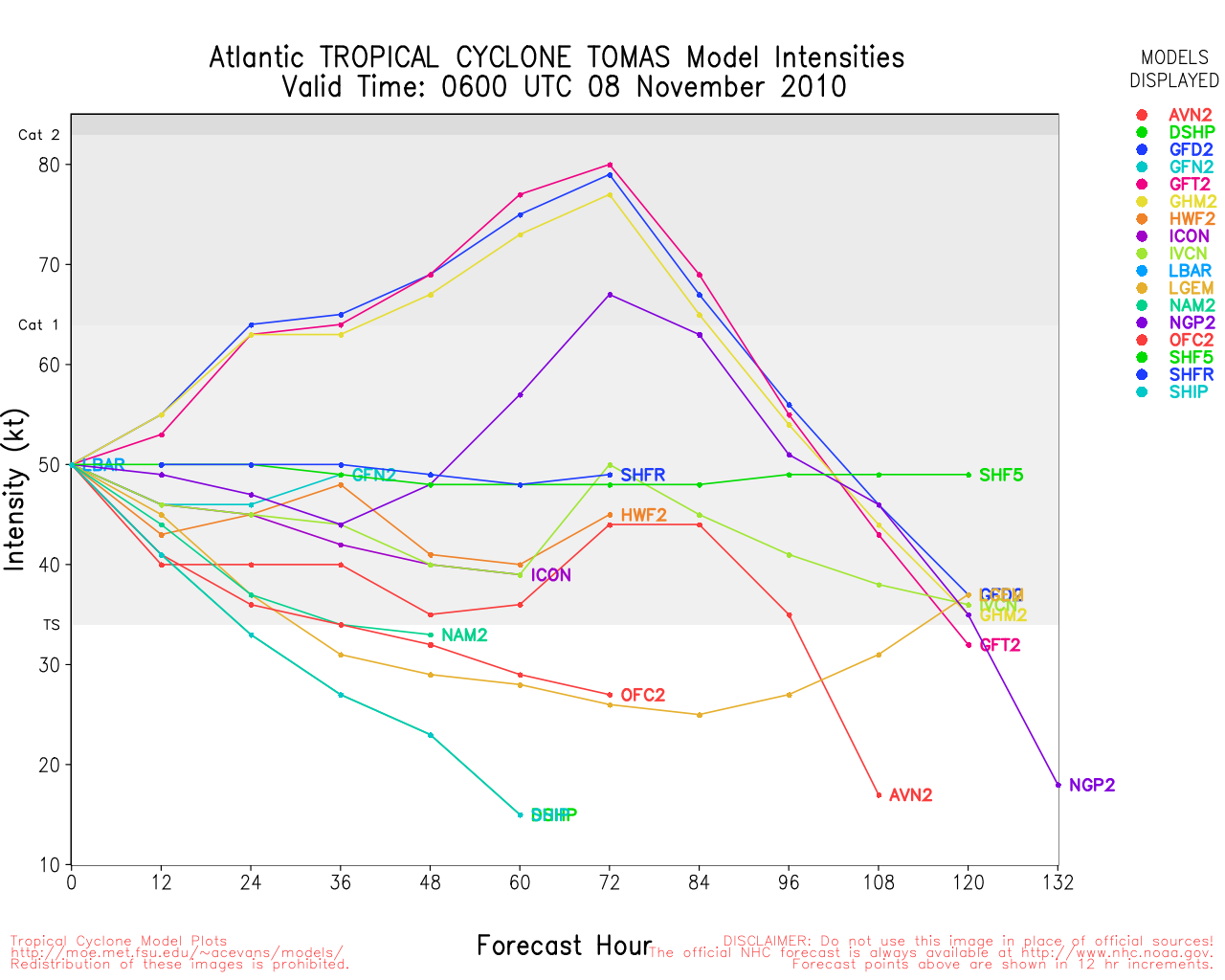
A bit of the Forecast Side of the Discussion, but noteworthy.
AFTER 48 HR...THE GUIDANCE IS
DIVERGENT AND INCONSISTENT. THE SHOWS TOMAS MOVING ALONG THE
SOUTHERN PERIPHERY OF THE DEEP-LAYER TROUGH...AND THIS IS
CONSISTENT WITH ITS PREVIOUS RUN. THE ...GFDL...AND HWRF NOW
CALL FOR TOMAS TO MOVE RAPIDLY NORTHWARD AND BE ABSORBED INTO THE
TROUGH...WHICH IS A MAJOR CHANGE FROM THE 6 HOUR OLD RUNS. ON THE
OTHER HAND...THE ...WHICH 6 HR AGO WAS CALLING FOR A
CONTINUED NORTHWARD MOTION...NOW CALLS FOR AN EASTWARD TURN SIMILAR
TO THE . OVERALL...THE GUIDANCE ENVELOPE HAS SHIFTED
NORTHWARD FROM THE PREVIOUS ADVISORY. THE 72-120 HR PORTION OF THE
TRACK WILL ALSO BE SHIFTED NORTHWARD...BUT IS WELL SOUTH OF THE
CONSENSUS MODELS AND THE CENTER OF THE GUIDANCE ENVELOPE. THIS
PART OF THE FORECAST TRACK IS LOW CONFIDENCE.
|
doug
Weather Analyst
Reged:
Posts: 1006
Loc: parrish,fl
|
|
It looks as though Sw'ly shear is winning out. I see an exposed circulation center at 16.2/76.4. If so the end is near as the shear willnot be abating with the approach of the deep trough. This system has been afflicted with these unexpected and unforecast obstacles.
--------------------
doug
|
Ed Dunham
Former Meteorologist & CFHC Forum Moderator (Ed Passed Away on May 14, 2017)
Reged:
Posts: 2565
Loc: Melbourne, FL
|
|
Tropical Storm Tomas has had a swirl possibly at mid-level or low-level rotating counterclockwise around a broader area of low pressure - probably centered closer to 17N 76.5W at 04/21Z - and just about stationary for the last few hours. Winds currently listed at 50mph which seems quite generous for a system that is not vertically stacked and has most of its convection displaced to the east by windshear.
Even though the latest forecast track keeps the cyclone over water though the Paso de los Vientos between eastern Cuba and western Haiti, unless the system structure improves significantly and soon, it would seem difficult for Tomas to regain hurricane intensity as the windshear increases. Looks more like a flooding rain event for Hispaniola with tropical storm force winds.
ED
Weather at Guantanamo Bay, Cuba
|


 Threaded


