MikeC
Admin
Reged: Sun
Posts: 4543
Loc: Orlando, FL
|
|
Hurricane Irene has made first landfall in the United States at Cape Lookout, NC as a 85mph hurricane. Winds to the west of the storm are relatively light but the storm surge has been fairly high so far. The eastern side is where the higher gusts have been reported.
It is moving north northeast, the outer banks will receive the eastern side of the storm.

What's happening weather wise or people wise regarding Irene in your area? Let us know here.
See the Forecast Lounge for more speculation on Irene.
Event Links
Flhurricane Disaster and preparatory information thread.
Landfall Area Media:
WECT 6TV - Wilmington, NC
WITN 7 - Eastern North Carolina TV (NBC)
WCTI 12 - Eastern North Carolina (ABC)
WNCT TV 9 - Eastern North Carolina (CBS)
Wavy 10 (NBC) - Hampton Roads/VA Beach, VA TV
WTKR 3 (CBS) - Hampton Roads/VA Beach, VA
WVEC 13 (ABC) - Hampton Roads/VA Beach, VA
Webcams: (south to north)
Live Myrtle Beach Cam
Myrtle Beach Earthcam
Bar Harbor Myrtle Beach Live Cam
Crown Reef Myrtle Beach Live Cam
North Myrtle Beach Controllable Cam (Flhurricane Recording of this camera
Holden Beach, NC Cam (flhurricane recording)
Oriental, NC Harbor Cam -- flhurricane recording
HurricaneTrack.com Tower Cam 1 (Hatteras) -- Flhurricane recording
Dare County Em Management
Papers:
Outer Banks Sentinel
Wilmington Star News Online
Hampton Roads Pilot
Power Outage Maps (roughly south to north)
Eastern Carolinas Power outage map
Virginia Power outage map
DelMarva Power outage map
Novec/Northern Virginia Power outage map
Portions Maryland/DC power outage Map
Baltimore area Power outage map
Southern Maryland Power outage map
Southeastern Pennsylvania Outage Map
Atlantic City (Southern New Jersey) Power outage map
Jersey Central Power outage map
Northern New Jersey PSEG outage map
New York City/ConEd Power outage map
Long Island Power outage map
Connecticut Power outage map
Rhode Island/Mass Power outage map
New Hampshire Power outage map
Audio streams of Various police/EM scanners
Keep up with where Mark Sudduth (Hurricanetrack.com) is as he drives around the Outer Banks of North Carolina
Chasercam live
CrazyMother Severe Weather Live Feed (Lot's of Nature Here)
Canadian Hurricane Centre
Irene Storm Surge Probabilities
Hope Town Fire rescue on Abaco Island, storm information
Updated Map of Mark Sudduth from HurricaneTrack.com, with video and radar for Irene approach See HurricaneTrack.com for more information.
RGB satellite recording of Irene.
Long Term Long Range US Radar of Irene
Level 3 Radar recording of Irene's NC approach (HCW)
Map plot of Irene overlaid on Hurricane Floyd (1999) as well as other notable New England storms
StormCarib Reports from the Caribbean Islands
Caribbean Weather Observations
Barbados Brohav Weather Fax
Full Caribbean Radar Composite
Caribbean Broadcast Corporation (TV/Radio from Antilles)
San Juan, PR NWS Page
Various Caribbean Radio Stations
DR1 Dominican Republic Hurricanes
Mid-Atlantic/Carolina Links
Southeast Composite Radar Loop
(Latest Static)
Charleston, SC Radar Radar Loop
(Latest Static)
Wilmington, NC Radar Radar Loop
(Latest Static)
Morehead City, NC Radar Radar Loop
(Latest Static)
Norfolk/Wakefield, VA Radar Radar Loop
(Latest Static)
Area Forecast Discussions:
Charleston, SC -
Wilmington, NC -
Morehead City, NC -
Norfolk/Virginia Beach/Hampton Roads, VA
Power Outage Maps:
South Carolina Power Outage Map
North Carolina Power Outage Map
Virginia Power Outage Map
Northeast US Radar Links
Northeast Composite Radar Loop
(Latest Static)
Dover, DE Radar Radar Loop
(Latest Static)
Mt. Holly, NJ Radar Radar Loop
(Latest Static)
Upton/NYC/Long Island, NY Radar Radar Loop
(Latest Static)
Boston/Cape Cod, MA Radar Radar Loop
(Latest Static)
Portland, ME Radar Radar Loop
(Latest Static)
Carabou, ME Radar Radar Loop
(Latest Static)
Irene Event Related Links


SFWMD Model Plot (Animated Model Plot) SFWMD Hurricane Page
[https://flhurricane.com/floatanimator.php?year=2011&storm=9 Flhurricane Satellite Floater Animation of Irene
GOES Floater
Animated Model Plot of Irene
Clark Evans Track Model Plot of Irene
(Animated!) Model Plots in Google Earth - In Google Maps
Clark Evans Intensity Model Plot of Irene (Animated!)
Clark Evans Track Plot of Irene
Other Model Charts from Clark
Clark Evans Top 10 Analog Storms for Irene
More model runs on from RAL/Jonathan Vigh's page
NRL Info on Irene -- RAMMB Info
COD Atlantic Satellite View
91L Event Related Links


SFWMD Model Plot (Animated Model Plot) SFWMD Hurricane Page
[https://flhurricane.com/floatanimator.php?year=2011&storm=11 Flhurricane Satellite Floater Animation of 91L
GOES Floater
Animated Model Plot of 91L
Clark Evans Track Model Plot of 91L
(Animated!) Model Plots in Google Earth - In Google Maps
Clark Evans Intensity Model Plot of 91L (Animated!)
Clark Evans Track Plot of 91L
Other Model Charts from Clark
Clark Evans Top 10 Analog Storms for 91L
More model runs on from RAL/Jonathan Vigh's page
NRL Info on 91L -- RAMMB Info
COD Atlantic Satellite View
92L Event Related Links


SFWMD Model Plot (Animated Model Plot) SFWMD Hurricane Page
[https://flhurricane.com/floatanimator.php?year=2011&storm=12 Flhurricane Satellite Floater Animation of 92L
GOES Floater
Animated Model Plot of 92L
Clark Evans Track Model Plot of 92L
(Animated!) Model Plots in Google Earth - In Google Maps
Clark Evans Intensity Model Plot of 92L (Animated!)
Clark Evans Track Plot of 92L
Other Model Charts from Clark
Clark Evans Top 10 Analog Storms for 92L
More model runs on from RAL/Jonathan Vigh's page
NRL Info on 92L -- RAMMB Info
COD Atlantic Satellite View
Long term Central Atlantic wide area Water Vapor Satellite for Hurricane Season Peak flhurricane)
Long term West Atlantic wide area Water Vapor Satellite for Hurricane Season Peak flhurricane)
|
MikeC
Admin
Reged: Sun
Posts: 4543
Loc: Orlando, FL
|
|
Cedar Island, NC is reporting 115mph wind gusts, the northeast side of the center of Irene seems to be where all the highest wind is at, and Ocracoke and that section of the outer banks seems to be getting it. Points west drastically less wind ,but surge is been driven up fairly high from the east there 6-8 feet.
Recon found pressure of 951, this is still a very powerful hurricane, but not in the classic high speed wind sense.
|
Random Chaos
Weather Analyst

Reged: Sat
Posts: 1024
Loc: Maryland
|
|
I'm looking at the area of North Carolina that the hurricane is crossing: it is all flat, swampy, with lots of lakes. It won't weaken the storm much.
Storm's appearance is actually improving on IR and WV following landfall. Morehead radar is still showing a badly disrupted eye, and the land interaction won't help it, but there are signs it is trying to fill in the southern and eastern circulation.
Condition report: Winds about 10-15mph here near Annapolis, MD. Still a long way from the storm, the eye being around 270 miles south of me. The closest rain line should start hitting me in the next ten minutes or so.
|
ralphfl
Weather Master
Reged: Mon
Posts: 435
|
|
The storm is doing that on it's own.The 85mph is high as it is more like 75 -80 and more and more dry air going in.The northeast is very lucky as a few days ago they were talking about on here of infastructure and stuff being damaged but all in all flooding rain and serge will be the main thing not the wind
|
StrmTrckrMiami
Weather Guru

Reged: Mon
Posts: 148
Loc: Manchester, NH
|
|
Well... Within the last night they changed it from being a TS when it hits here, to a Cat 1. I'm expecting when it hits to get the strong winds (at least that is the side of the line we are on, and so because were on the west side of her when she hits, they're saying were going to get strong winds of hurricane force)
Last night I think everyone started taking it seriously when the Governor declared a state of emergency for NH. I grabbed some essentials from Wal-Mart, but they are out of them today as well as water. Good to see that people are stocking up on supplies around here and preparing to take her seriously... but sad to see some people still think it is a big joke.
She seems to be a smart storm, staying closer to the water than going inland. I have to agree with what Random Choas has said about the badly disrupted eye and the appearance of her on radar. She is still very powerful even though she is a Cat 1 and very large. I'm curious to see what she will do later tonight.
On a side note -- I'll be around to post as much as I can but if the power goes out, or I'm called to assist (Since I have disaster training for these sorts of things, and am trained as a first responder) than I will not be around much -- I have my phone, so will try to report conditions as she hits in NH from my phone.
--------------------
Tracking Storms Since 2004
Miami, Cocoa, Fort Myers and Jacksonville
Currently Reside in New England
|
Random Chaos
Weather Analyst
Reged: Sat
Posts: 1024
Loc: Maryland
|
|
Looking at Morehead radar, looks like the eyewall has almost completely regenerated with only a small gap on the ENE side. The eye is very much rain filled and quite ragged, but it does exist. The storm has definitely recovered from the dry air ingestion that occurred overnight. It's still hours from reentering oceanic water, and the eye may not hold together until then. If it does hold together, expect a small amount of restrengthening off the coast before it starts impacting the Delmarva.
Conditions 1140: outside Annapolis, MD: 15-25mph winds; sporadic light rain.
My anemometer is reporting low by about 5-10mph...had to use a hand gauge. 
And just in case anyone is wondering about my sanity, my command center. 
Edited by Random Chaos (Sat Aug 27 2011 12:13 PM)
|
MikeC
Admin
Reged: Sun
Posts: 4543
Loc: Orlando, FL
|
|
Even slightly inland (over swampy area anyway) Irene seems to be holding where it is, recon actually found pressure of 947 mb (lower than earlier). So Irene is a very non-typical storm. I'm sure it will be analyzed a lot over the next few months.
It moved nearly due north after landfall, but now appears to be moving more north northeast. Strangely also, the east side has dried out and most of the convection has swung over to the west side (At landfall it most mostly north and east), which is not good for points north. Rain bands already extend into New York, while the center still remains in the sounds of North Carolina.
|
Random Chaos
Weather Analyst
Reged: Sat
Posts: 1024
Loc: Maryland
|
|
At landfall, there was no eyewall nor eye. The entire core was disrupted.
Look at this radar image from 10 minutes ago. Eyewall well established. Rain free eye.
This all happened after landfall! Wow.
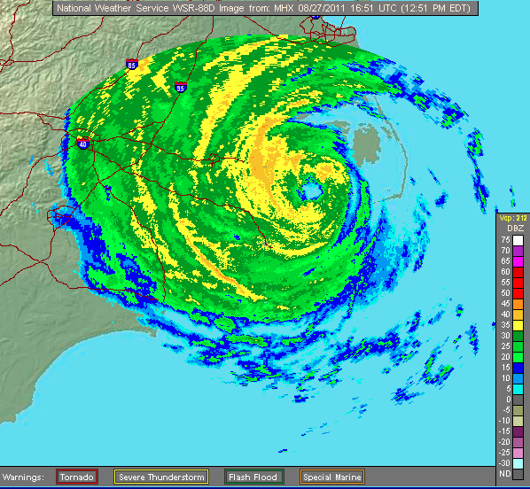
Note: I turned off county borders. If you look at actual land locations, the eye is actually over an inlet, centered on this map just east of between Lowland in the south and Germantown in the north. Both the north and south eyewall are over land. The storm just exited from being overland on the Lowland side and is heading toward Lake Mattamuskeet.
Edited by Random Chaos (Sat Aug 27 2011 01:08 PM)
|
Random Chaos
Weather Analyst
Reged: Sat
Posts: 1024
Loc: Maryland
|
|
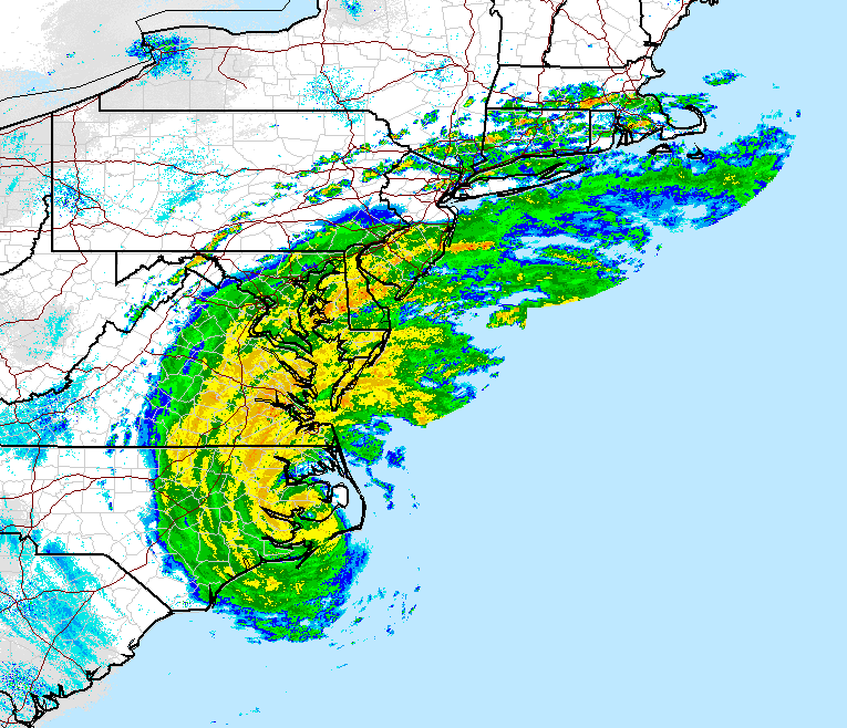
Both WV and Radar are showing what appears to be some dry air being ingested on the eastern side of storm, just outside the eyewall. It can be seen in this regional shot showing the total area of affect of Irene:
|
Random Chaos
Weather Analyst
Reged: Sat
Posts: 1024
Loc: Maryland
|
|
Bad Information Warning:
I have seen local news websites linking to a simulation of worst case scenario storm surges on the Chesapeake Bay based on a hurricane coming strait up the Bay. This study was done after Isabel and is not anything like what you will see with Irene on the Chesapeake Bay. Repeat, this is not what will happen with Irene.
The track of Irene is too far east and the track of Irene has already taken it over land, reducing the surge "drag" that accumulates over time. Irene will have major storm surges along the Atlantic coast including Norfolk, very southern Chesapeake Bay, much of the Delaware Bay, northern New Jersey, New York City, and Long Island. It will not have a major storm surge on the majority of the Chesapeake bay, and in fact the latest models I am watching show a negative surge in the northern bay due to winds pushing water south.
Please refer to the surge probability diagrams produced by the :
http://www.nhc.noaa.gov/psurgegraphics_at4.shtml?gm
You can also use the NWS coastal Operational Forecast System models that include tide simulations:
http://tidesandcurrents.noaa.gov/models.html
Edited by Random Chaos (Sat Aug 27 2011 02:49 PM)
|
OuraganTornade
Registered User
Reged: Sat
Posts: 1
|
|
Hi everyone , new to the forums but been a lurker for quite some time.
I finally registered because for the first time it looks like a storm is coming right at us in Montreal so I would like your opinion on what I should be expecting in my area.
thanks and stay safe
|
Random Chaos
Weather Analyst
Reged: Sat
Posts: 1024
Loc: Maryland
|
|
Ouragan:
The biggest threat from a storm that has moved well inland is in the form of tornadoes. The large amount of spin in a storm can generate a large number of tornadoes. The second big threat from a storm is the rainfall. It looks like the storm will pass your area relatively quickly, but be prepared for quite a few inches of rain with the possibility of flash flooding.
Wind will be less of an issue at your distance from the Atlantic coast. The storm will still pack quite a lot, but most of it will not be reaching the ground. Most likely you'll get your strongest winds within embedded thunderstorms rather than from the cyclone itself.
The centerline track is well east of Montreal, so you will be on the western side of the storm. You may be far enough out to not experience a lot depending on track, but I'd keep alert to your weather services and for any warnings of significant weather (I don't know what services Canada provides - maybe someone else can fill this in).
This is the nearest US weather radar to your location:
http://radar.weather.gov/ridge/radar.php?rid=cxx&product=N0R&overlay=11101111&loop=no
|
MikeC
Admin
Reged: Sun
Posts: 4543
Loc: Orlando, FL
|
|
Hurricanetrack guys steam at Roanoke sound on the east side where the water has been blown out (ie mud) http://www.hurricanetrack.com/ (map of their current location)
|
cieldumort
Moderator

Reged: Mon
Posts: 2305
Loc: Austin, Tx
|
|
Quote:
Ouragan:
The biggest threat from a storm that has moved well inland is in the form of tornadoes. The large amount of spin in a storm can generate a large number of tornadoes. The second big threat from a storm is the rainfall. It looks like the storm will pass your area relatively quickly, but be prepared for quite a few inches of rain with the possibility of flash flooding.
Wind will be less of an issue at your distance from the Atlantic coast. The storm will still pack quite a lot, but most of it will not be reaching the ground. Most likely you'll get your strongest winds within embedded thunderstorms rather than from the cyclone itself.
This is actually not correct in general, and particularly not with Irene.
The primary, greatest threat from tropical cyclones once they have moved well inland is actually from inland flooding.
Tornadoes rank relatively low on the threats from inland tropical cyclones. Most of the misunderstanding is the result of a disproportionate number of hurricanes making landfall in the south, where extremely warm water temps do tend to encourage enough convection to occasionally result in what could legitimately be called a big tornado outbreak; from there, the media, Internet and such, do the rest in creating this perception.
This is not to say that tornadoes are not, or will not, be a threat with Irene. Indeed, several brief tornadoes have already occurred, and will likely continue to do so for some time as Irene travels up the coast.
When it comes to Irene, much of the northeast has experienced one of its wettest Augusts on record, and Irene is producing very copious rains over large areas of land that are already well saturated. Irene is moving relatively slow (especially for a hurricane moving up the east coast), and this 1-2 punch is creating a very high flood threat.
You can read more about the threats associated with inland tropical cyclones here.
|
Random Chaos
Weather Analyst
Reged: Sat
Posts: 1024
Loc: Maryland
|
|
Ah, I am used to Gulf storm remnants tracking up over Maryland that often spawn large amounts of tornadoes. I tend to forget about flooding threats due to terrain in my region not conducive to much in the way of flooding. Thanks for correcting that Cieldumort.
|
Random Chaos
Weather Analyst
Reged: Sat
Posts: 1024
Loc: Maryland
|
|
Vortex recon from about a half hour ago. The storm was over Albemarle Sound at the time this was taken. It has since crossed back onshore and will be moving into the Atlantic soon just south of Virgina Beach (near Corolla).
Product: Air Force Vortex Message (URNT12 KNHC)
Transmitted: 27th day of the month at 20:34Z
Aircraft: Air Force Aircraft (Last 3 digits of the tail number are 303)
Storm Number & Year: 09L in 2011
Storm Name: Irene (flight in the North Atlantic basin)
Mission Number: 33
Observation Number: 17
A. Time of Center Fix: 27th day of the month at 20:03:50Z
B. Center Fix Coordinates: 36°00'N 76°07'W (36.N 76.1167W)
B. Center Fix Location: 25 miles (40 km) to the W (266°) from Kill Devil Hills, NC, USA.
C. Minimum Height at Standard Level: 2,630m (8,629ft) at 700mb
D & E. Estimated (by SFMR or visually) Maximum Surface Wind: Not Available
F. Maximum Flight Level Wind Inbound: From 157° at 73kts (From the SSE at ~ 84.0mph)
G. Location of Maximum Flight Level Wind Inbound: 29 nautical miles (33 statute miles) to the ENE (67°) of center fix
H. Minimum Sea Level Pressure: 950mb (28.05 inHg)
I. Maximum Flight Level Temp & Pressure Altitude Outside Eye: 12°C (54°F) at a pressure alt. of 2,744m (9,003ft)
J. Maximum Flight Level Temp & Pressure Altitude Inside Eye: 16°C (61°F) at a pressure alt. of 2,744m (9,003ft)
K. Dewpoint Temp (collected at same location as temp inside eye): 16°C (61°F)
K. Sea Surface Temp (collected at same location as temp inside eye): Not Available
L. Eye Character: Not Available
M. Eye Shape: Not Available
N. Fix Determined By: Penetration, Radar, Wind, Pressure and Temperature
N. Fix Level: 700mb
O. Navigation Fix Accuracy: 0.02 nautical miles
O. Meteorological Accuracy: 2 nautical miles
Remarks Section:
Maximum Flight Level Wind: 87kts (~ 100.1mph) in the east quadrant at 19:36:00Z
|
cieldumort
Moderator
Reged: Mon
Posts: 2305
Loc: Austin, Tx
|
|
No doubt about it, Irene re-intensified a little bit throughout the day.
A couple of different factors at play today working together to make the increased organization possible: 1) Appreciably improved outflow 2) initial land interaction, resulting in banding right around the center curving back inwards, and 3) much of the circulation remaining over warm water.
The land interaction and warm water is diminishing tonight, and shear is forecast to increase. Nonetheless, Irene is going to take a pretty long time to spin down. Residents further north along the coast should not be fooled into any sort of sense of safety by her Category 1 status. Most Category 1 hurricanes never get anywhere close to as low as 950mb. Irene is a monster cyclone.
|
DaViking
Verified CFHC User

Reged: Tue
Posts: 23
Loc: Crystal River, FL
|
|
Center appears to be passing over or near Duck Pier, NC.
Station DUKN7
Winds are sustained at 67 mph gusting to 78 mph as of 5:06 pm with a pressure of 950.9 mb.
pressure could be reporting 1.5 mb lower.
--------------------
Lived in Florida 31 years and have never been in a hurricane. I lived in Miami in 1992, but was out of country. Sorry Miami. Then moved north in 1999. again, sorry Miami.
|
MikeC
Admin
Reged: Sun
Posts: 4543
Loc: Orlando, FL
|
|
Roanoake Sound east of Manteo, NC
3:45PM Today

5:45PM Today

Photographer: Mike Watkins/Hurricanetrack.com
The surge is still rising, see it on the hurricanetrack stream
Updated Map of Mark Sudduth from HurricaneTrack.com, with video and radar for Irene approach See HurricaneTrack.com for more information.
|
danielw
Moderator

Reged: Wed
Posts: 3525
Loc: Hattiesburg,MS (31.3N 89.3W)
|
|
Great catch!
Center looks to be closest to Currituck,NC
Latest METAR from the airport:
ICAO KONX
Station Name Currituck
Country US: North Carolina
Location 36.40N 76.02W
Elevation 16 ft
Time 27 / 21:55Z
Temperature 74.3
Dew Point 72.0
RH 92
Heat Index 72.3
Wind NNW (340) at 23kts, 33 gusts
Visibility 1.0 sm
Pressure 953.6 mb
Weather Heavy Rain
Sky Condition Overcast at 500ft
Remarks Hourly Precipitation Amount: 0.61 inch
METAR KONX 272155Z AUTO 34020G29KT 1SM +RA OVC005 24/22 A2816 RMK AO2 P0061 T02350222
|


 Threaded


