MikeC
Admin
Reged:
Posts: 4544
Loc: Orlando, FL
|
|
Update - Monday, September 5th, 2011, 11:35AM EDT
At 05/09Z, the NWS Hydrometeorological Prediction Center relocated Ex-TD Lee at 30.2N 90.8W - still in Louisiana, and at 05/12Z, used 30.4N 90.2W for an additional model run on Lee. At 05/15Z, the remnants of Lee were located at 30.5N 89.9W with movement over the past 12 hours generally to the east. The system is about to enter southern Mississippi and move into Alabama tonight.
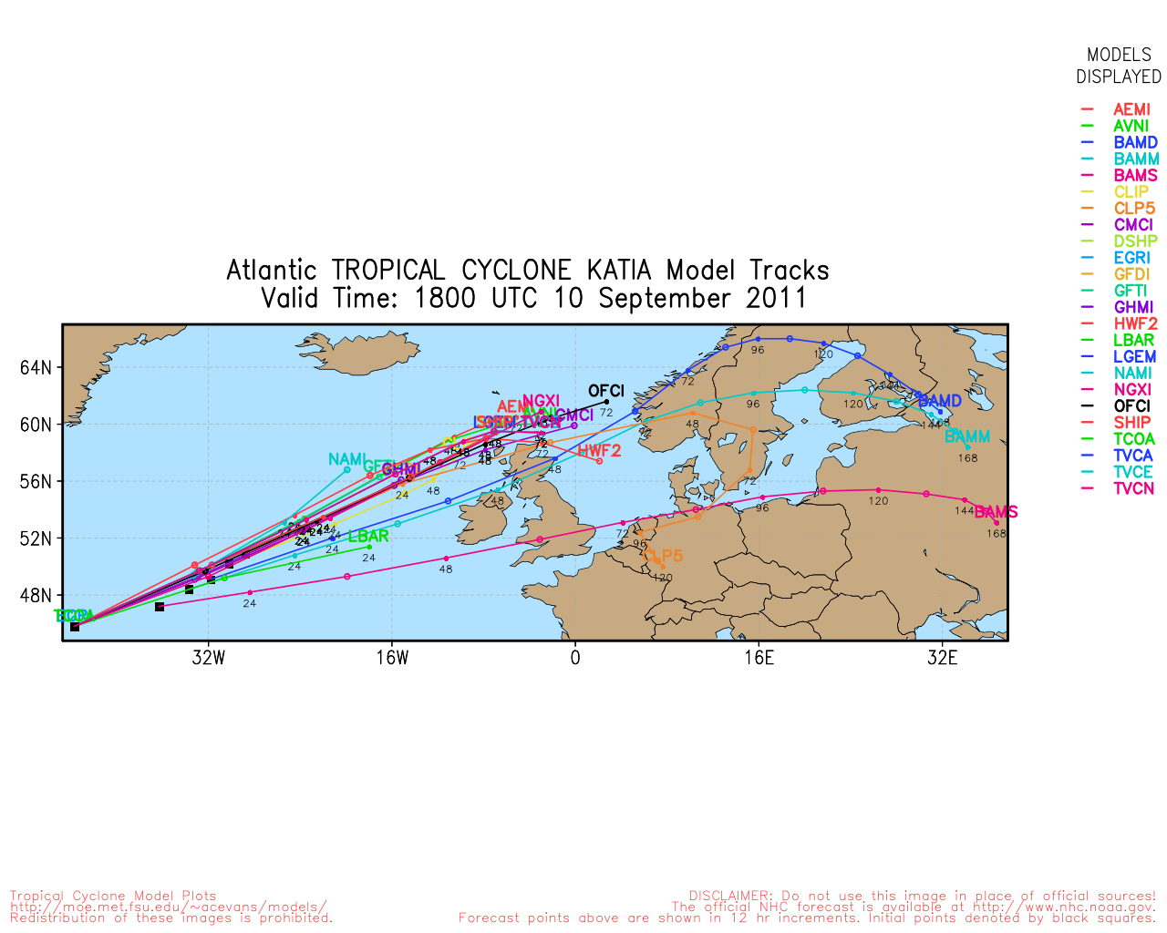
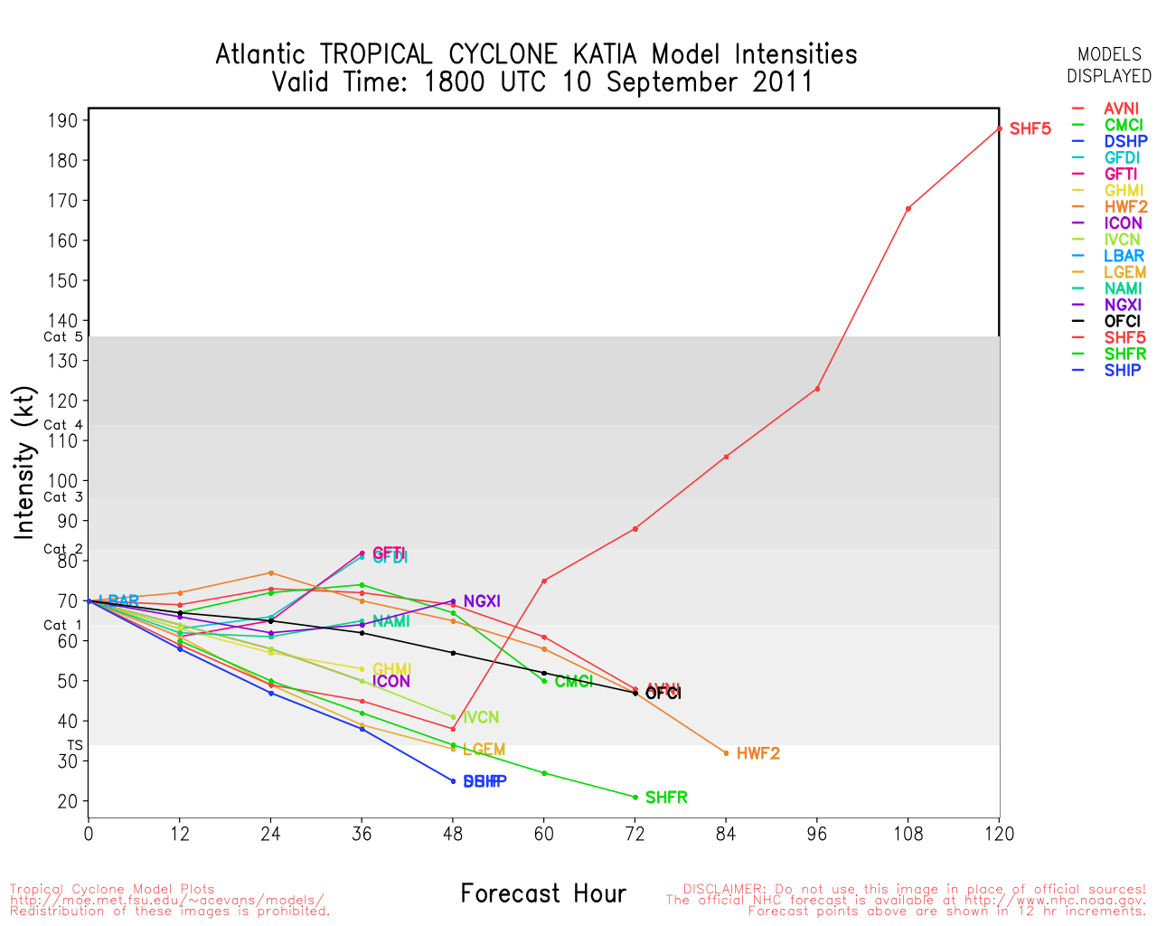
Hurricane Katia has completed an eyewall replacement cycle - a bit unusual but not unheard of for a Cat II Hurricane - and movement over the past 6 hours has been more to the WNW rather than NW although the 12-hour average is still NW. expects a general NW motion to continue with an eventual turn to the north and northeast. The track has again adjusted slightly to the east, and although Bermuda, North Carolina, Massachusetts, Nova Scotia and Newfoundland are not in the cone, the overall area of tropical storm force winds has been expanded so some gusty winds will be likely in Bermuda and possible elsewhere along the coast as Katia passes by well offshore during the week.
The tropical wave in the far eastern Atlantic has been designated as Invest 95L. At 05/12Z, 95L was located well southwest of the Cape Verde Islands at 9.1N 29.7W with winds of 25 knots and pressure at 1009MB. Movement overnight was to the west at 14 knots. The tropical wave is developing good structure and active convection with additional development likely as the system moves to the west and west northwest over the next few days.
ED
Update - Monday, September 5th, 2011, 12:15AM EDT
Category II Hurricane Katia is located well to the north of the northern Leeward Islands still moving to the northwest at 13mph. Some additional intensification is possible for the next couple of days as Katia continues to move to the northwest, eventually turning to the north and then northeast. Models have adjusted eastward and so has the forecast track. An upper level low near 32N 52W could begin to have more of an influence on the future track of Katia. Bermuda is currently not in the cone, but additional eastward adjustments to the track are possibly so folks in Bermuda still need to closely monitor any changes in Katia's track.
By midweek, Katia will begin to move over cooler SSTs and this should slowly reduce the sustained winds later in the week. With fairly good model consensus, its looking more and more like Hurricane Katia will remain at sea - but continue to monitor Katia for any unexpected changes. High surf and rip currents are anticipated along most of the eastern seaboard, in the Bahamas, and on Bermuda in the week ahead. Check with your local forecast office for details on expected hazardous beach conditions in your area.
NHC has issued its final advisory on Tropical Depression Lee. Winds and convection are both decreasing as Lee transitions to an cyclone. All Tropical Storm Warnings have been discontinued. Post TD Lee is now moving northeastward in south central Mississippi and will be moving toward northern Alabama over the next couple of days where the system is expected to merge with a shortwave trough. Flooding rains are still expected to move from the central Gulf coast into the Appalachian Mountains.
An active tropical wave near 9N 28W at 05/04Z is the only other noteworthy feature in the basin at this time.
ED
8:30 AM 4 September 2011 Update
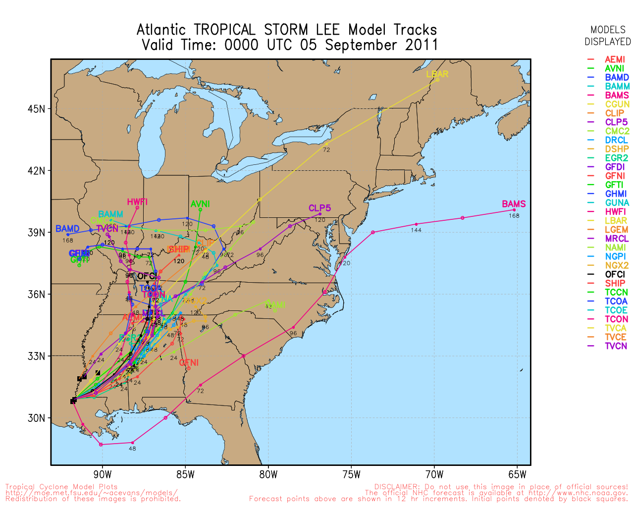
Tropical Storm Lee still is still over the coast of south central Louisiana, near Vermillion Bay. Lee is still quite disorganized, with much of the convection gone on the southwest, and northwestern quadrants.
Some strong rain bands are moving through the Florida Panhandle and Alabama today, and will move up through parts of Mississippi, Louisiana, Arkansas, Alabama, Western Georgia and Tennessee over the next few days as lee weakens over land. The tropical storm warning goes from Destin, FL westward to Intracoastal city, LA.
Katia's official forecast has shifted a bit west from yesterday, however most guidance and water vapor analysis still suggests that it most likely will recurve before the United States. The trends will need to be monitored (especially the trends of the UKMet model vs the trends of virtually everything else). But right now there are more factors favoring a recurve.
7:28 AM 3 September 2011 Update
Bands of heavy rain along with tornadoes continue in the Central and Northeastern Gulf coasts, all associated with Tropical Storm Lee. It's still moving northward but still remains rather disorganized, another few days of rain is expected in the area.
Katia's holding as a category 1 hurricane, as it moves northwest, odds have slightly increased that it will recurve before the US.
1:30 PM 2 September 2011 Update
THIRTEEN has been upgraded to Tropical Storm Lee. While Lee is expected to intensify, within still weak steering currents, flooding will likely continue to be the greatest threat.
6:30 AM 2 September 2011 Update
Tropical Depression 13 remains a highly sheared, but active tropical depression.
Right now, the western side of the storm remains fairly dry, while the eastern side is extremely wet. With the shear, if the storm forms it will likely be a larger system without a strong inner core, which would make it highly unlikely to strengthen too much.
It will, however, be enough to bring large amounts of rainfall to the Northern Gulf, and some rainfall to the eastern Gulf. It is possible for the storm to be closer to a hybrid storm than a classic tight core tropical cyclone. Upwelling will also likely prevent too much intensification. The forecast calls for it to be upgraded to a Tropical Storm later today.
Texas it looks like, unfortunately, won't see much from this system.

There is virtually no movement with the storm right now, as the center is relocating more than moving, and the steering currents remain weak, which means days of the system offshore, bringing band after band of rain to Louisiana and surrounds, with heavy rain and the possibility of short lived tornadoes.
Any east facing coastal areas in the Northern Gulf will be prone to some coastal flooding with prolonged easterly winds. Winds will be slow at first, but gradually increasing through the days until the system exits. Rainfall will be very dependent on where the bands go, 5-10" is possible, some places more.
Track wise, pick a place, there is very little skill at forecasting a track of a virtually stationary tropical storm, generally anywhere in the tropical storm Warning area.
Katia remains a tropical storm this morning, and odds still marginally favor it turning out to sea before the United States. The area south of Nova Scotia may have a chance to develop before it gets into areas too cold.
Original Update
Tropical Depression 13 forms in the Gulf of Mexico about 225 miles southwest of the mouth of the Mississippi river.
Tropical Storm warnings are now up for the northern Gulf of Mexico coastline from Pascagoula, Mississippi westward to Sabine Pass, TX.

Tropical Depression 13 is forecast to become Tropical Storm Lee tomorrow. It is expected to move extremely slowly as it approaches the northern Gulf coastline, dumping very heavy rainfall.
TD#!3 is a borderline tropical depression, and is still quite disorganized at the moment and the center may "Reform" a few times before it gets its act together. Those in the Tropical Storm warning area will likely see an extended period of windy conditions with wave after wave of heavy rainfall.
Katia was downgraded to a Tropical Storm being under the influence of shear, it is forecast to regain strength later. Although odds still slightly favor recurve from the US, it is not a healthy margin and needs to be monitored over the next week or so. It appears it will go safely northeast of the Caribbean, however.
Long term Central Atlantic wide area Water Vapor Satellite for Hurricane Season Peak flhurricane)
Long term West Atlantic wide area Water Vapor Satellite for Hurricane Season Peak flhurricane)
Edited by Ed Dunham (Mon Sep 05 2011 03:43 PM)
|
MichaelA
Weather Analyst

Reged:
Posts: 944
Loc: Pinellas Park, FL
|
|
Granted, the has much more info than I have, but did they jump the gun here because it's in the Gulf, close to land, and the models are showing development? I have no doubt that something is happening in the Gulf, but it sure doesn't look very well formed right now.
--------------------
Michael
PWS
|
watchinout
Verified CFHC User
Reged:
Posts: 17
|
|
I was thinking the same, but judging by the very latest SAT. images it looks like something is about to take off. This is the first real time that any spin is noticable.
|
Ed Dunham
Former Meteorologist & CFHC Forum Moderator (Ed Passed Away on May 14, 2017)
Reged:
Posts: 2565
Loc: Melbourne, FL
|
|
The system is still disorganized, but admitted that in their initial Discussion Bulletin. With a lopsided appearance (often typical of weak Gulf systems) it looks more subtropical - but not with SSTs of 31C. Given the stature of the Sr Hurricane Forecaster that was part of the team that developed the initial bulletins, I'm more than willing to watch this pot boil for awhile. Its certainly not classic structure, but its hard to ignore those earlier reports from the offshore oil platforms with gusts over 40mph. The real worry with this coast-crawler would be the high rainfall and flooding potential - which is going to be true even if the TD never makes it to TS status.
ED
|
javlin
Weather Master
Reged:
Posts: 410
Loc: Biloxi,MS
|
|
I think it will make TS status eventually hurricane I will have to wait and see.The thing I am wondering does the storm relocate further to the SE? The area which appears may have the lower pressures just from thunder storm activity.I never really could locate a spin of any type at the spot earlier really.Have to see in the morning if NOAA plane finds anything tonight but have to agree it's a mess ATTM
|
Random Chaos
Weather Analyst

Reged:
Posts: 1024
Loc: Maryland
|
|
Current guidance is only calling for the gulf system to reach Tropical Storm, but with the gulf at this time of year you can never rule out an unexpected rapid intensification, as has been seen numerous times with previous systems.
The biggest threat by far from that storm is going to be rain, with most models clustering from 2 to 4 days of heavy rain along the gulf coast. A few outliers are showing upwards of a week or more of heavy rain.
All models are fairly well in agreement that there is very little in the way of steering current, which will allow the storm to basically meander around a bit before finally moving north.
--
As for Katia, anyone watching IR? It's growing. More than doubled the size of the since yesterday, and most of that has been within the last 2-3 hours. There is also some very deep convection in the .
Edited by Random Chaos (Fri Sep 02 2011 03:46 AM)
|
cieldumort
Moderator

Reged:
Posts: 2305
Loc: Austin, Tx
|
|
Quote:
The thing I am wondering does the storm relocate further to the SE? The area which appears may have the lower pressures just from thunder storm activity.I never really could locate a spin of any type at the spot earlier really.Have to see in the morning if NOAA plane finds anything tonight but have to agree it's a mess ATTM
This is a really good question, and one which I have been considering throughout the day, as well. The initial center location as determined by after Recon made a number of passes was not that impressive, and remains under moderate shear. Meanwhile, where the convection is strongest - a good distance to its southeast - is also just about ideally situated under favorable winds aloft.
Weak tropical cyclones (and one could arguably have seen TD13 going at least another few hours without having officiated it, as it is just that weak) are much more likely to have center reformations. While the location identified by has appeared to be the most prominent, at the time that made the upgrade I could count no less than four surface swirls in the GOM, plus also one just inland over eastern Mexico.
If the location of TD13 does jump, this will call in to question the viability of all of the initial model runs. Models are only going to be as good as the data which goes in to them, and in the case of THIRTEEN, much greater discernment may need to be used.
As can be seen in the image below, both convection and wind barbs support the notion that THIRTEEN may already be in the process of consolidating well to the southeast. The red "L" is roughly the initial location of THIRTEEN as identified by during the first Advisory. The red "NC?" stands for New Center?

On the other hand, this recent ASCAT pass from 0248Z suggests that the original, -declared center, remains largely intact, but has drifted (or reformed) to the south-southwest:
 . .
With Recon scheduled to make another fly into THIRTEEN later tonight, we will hopefully have a better clue as to what the system is doing come daybreak.
|
mikethewreck
Weather Hobbyist

Reged:
Posts: 52
Loc: Treasure Coast FL
|
|
And my buddy 94L (SE of Nova Scotia) is up to 60% chance of development now in the 5AM update already showing TS wind gusts.
--------------------
Earliest memory Hurricane Cleo!
Went under Hurricane Gloria!
|
Joeyfl
Weather Guru

Reged:
Posts: 133
Loc: St.Pete,FL
|
|
It looks to me as though TD 13 center is somewhere on the western side of deep convection. I expect ceter reformations along with lots of shifts, as stated this morning. Wouldn't be surprised to see this a Tropical storm on next update seeing how deep convection is near and east of center.
|
MichaelA
Weather Analyst
Reged:
Posts: 944
Loc: Pinellas Park, FL
|
|
It looks to me that the center of a rather broad circulation is near 26.6N; 92.0W just on the western side of the convection in the latest RGB floater loop. As others have stated, this is going to be a major rain maker for the northern Gulf coast.
--------------------
Michael
PWS
|
javlin
Weather Master
Reged:
Posts: 410
Loc: Biloxi,MS
|
|
In looking at the sats this morning the cloud cover has expanded 120miles to the W over the last seven hrs or so it does appear that wind shear is lessening
http://www.ssd.noaa.gov/goes/flt/t1/flash-vis.html
|
doug
Weather Analyst
Reged:
Posts: 1006
Loc: parrish,fl
|
|
There is some indication that winds are 35kt and that thirteen will be Lee at 27N 91.6 W.
--------------------
doug
|
JMII
Weather Master

Reged:
Posts: 489
Loc: Margate, Florida
|
|
A better question is what's up with Katia? The lastest model runs show a W motion followed by a rapid run to the N. I realize currently there is a major ridge blocking her to the W, but a high seems to be building in behind her to the NE. Just wondering how close she'll get to the east coast before that turn occurs. Katia is really elongated along the N/S axis, with almost no outflow on the SE and keeps toying with become a really hurricane.
I'm not even going to guess on TD#13... it is in an messy environment that makes no sense, however the whole gulf is full of moisture, so hopefully some of that makes it to TX they need it badly.
--------------------
South FL Native... experienced many tropical systems, put up the panels for:
David 79 - Floyd 87 - Andrew 92 - Georges 98 - Frances 04 - Wilma 05 - Matthew 16 - Irma 17
Lost our St James City rental property to Ian 22
Edited by JMII (Fri Sep 02 2011 03:06 PM)
|
TXEB
Weather Watcher

Reged:
Posts: 30
Loc: Lake Jackson, TX
|
|
Looks like 13 is going to hang out over southern LA, MS and AL for close to 48 hours. Regional advisory for the same is 10-15 inches of rain with local amounts up to 20 inches. From personal experience on the Gulf Coast, that is a lot of water over 48 hours.
Wish we could get some of that rain over here is SE TX. We're parched -- only had 10.62" on the year.
|
MichaelA
Weather Analyst
Reged:
Posts: 944
Loc: Pinellas Park, FL
|
|
A definite location for the center is really difficult for me to see on the sat loops. It looks like there have been several small vortices forming and then dissipating within a very broad circulation.
--------------------
Michael
PWS
|
Ed Dunham
Former Meteorologist & CFHC Forum Moderator (Ed Passed Away on May 14, 2017)
Reged:
Posts: 2565
Loc: Melbourne, FL
|
|
Latest satellite suggests that may have been premature in returning Katia to hurricane status. Is it really an eye or is it simply an exposed center - there is quite a difference? Convection is now displaced to the west and northwest and the center is not under any feature, with considerable weakness to the southeast. Probably still a strong TS.
ED
|
MichaelA
Weather Analyst
Reged:
Posts: 944
Loc: Pinellas Park, FL
|
|
Looks like dry air entrainment on the south side to me. Katia may have temporarily made minimal hurricane status before the dry air got in there, but may be back to TS now.
--------------------
Michael
PWS
|
MichaelA
Weather Analyst
Reged:
Posts: 944
Loc: Pinellas Park, FL
|
|
Back to TS Lee: Lots of dry air on the western side continues to inhibit much strengthening with all of the convection in the East and North quadrants. The 2 PM ET center location from the looks pretty close on the vis floater loop.
--------------------
Michael
PWS
|
Random Chaos
Weather Analyst
Reged:
Posts: 1024
Loc: Maryland
|
|
I am watching Katia closely. Lee is affecting the weakness in the ridge that was forecast to allow Katia to make it's northward turn, slowing the eastward progression of the weakness. Long range models are now showing the weakness closing before Katia reaches it. A new weakness is shown forming shortly before Katia reaches the east coast, but I question the strength of that weakness given that it is not being driven by a frontal zone - it looks like the is overpowering the decay of the ridge.
If you are anywhere from North Carolina through Canada, keep a close eye on Katia. The likelihood that it will re-curve before reaching the US is decreasing. Right now long range models are showing a re-curve just off the US coast and impacting only Prince Edward Island, but only a slight change in timing or course could cause it to hit the US.
|
Random Chaos
Weather Analyst
Reged:
Posts: 1024
Loc: Maryland
|
|
18Z modelz are out and show even more of a westward shift to Katia. Anyone from Florida to Canada needs to watch this storm.
Summary:
HREF shows a strait track with no recurve toward southern east coast, FL though NC.
GFS shows a slow recurve with possible mid-Atlantic hit.
GFDL is a little south and less recurve than
NOGAPS 12Z is recurving a little faster than
ECMWF 12Z is close to the
|


 Threaded


