MikeC
Admin
Reged:
Posts: 4544
Loc: Orlando, FL
|
|
2:30 PM EDT 22 July 2013 Update
Watching a new wave in far eastern Atlantic, new article to come tonight.
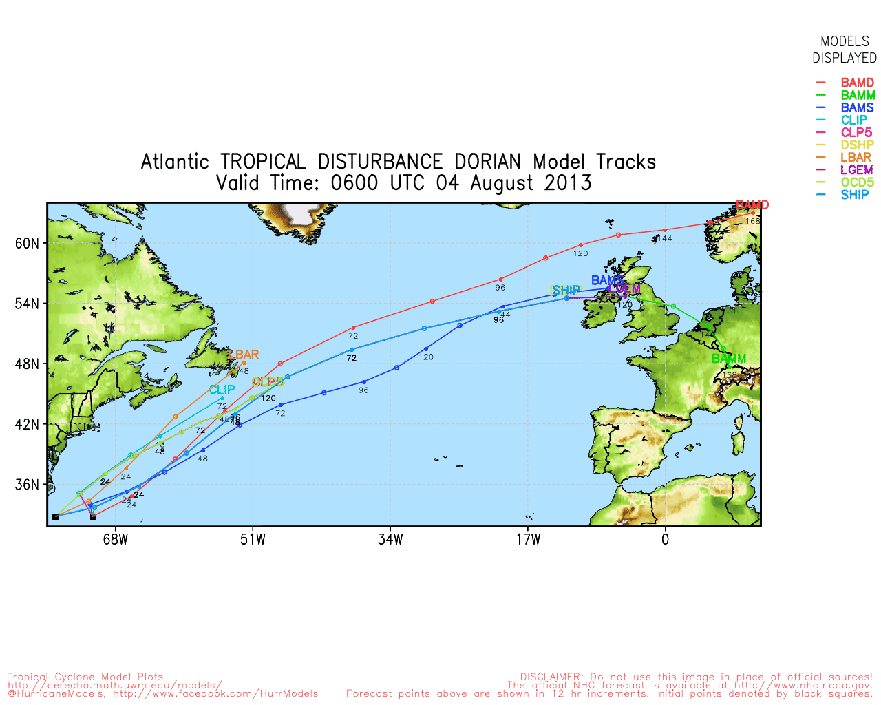
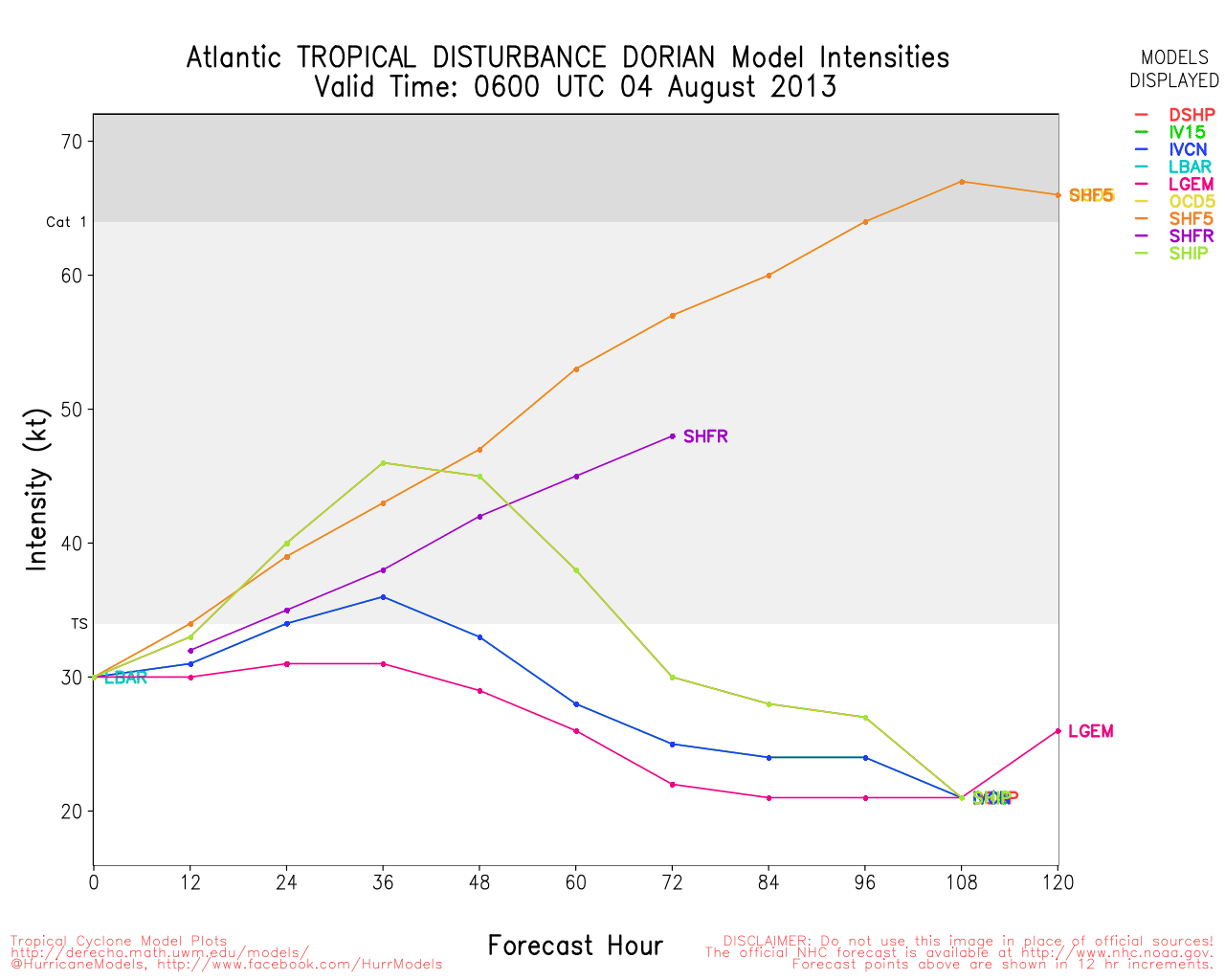
At 22/18Z, Invest 98L was slowly consolidating its increasing convection near 12.2N 18.9W, or southeast of the Cape Verde Islands just off the west coast of Africa. Pressure was 1009MB, SST is 28.5C, sustained winds were at 25 knots and movement was to the west at 12 knots. The system is currently moving through an area of light windshear so some additional development is possible in the next couple of days. Future movement should be to the west and west northwest with the system beginning to encounter an increase in westerly upper windshear by late Wednesday or early Thursday.
7:30 AM EDT 13 July 2013 Update
A small low pressure area appears to be trying to form in the northern Gulf, but proximity to land will likely keep it able to develop, 10% chance based on the hurricane center. This low is associated with an inverted trough over the Tennessee river valley south.
The remnants of Chantal continue to persist as they drift around, mostly toward the north, 20% development chance there, but still more likely to never develop.
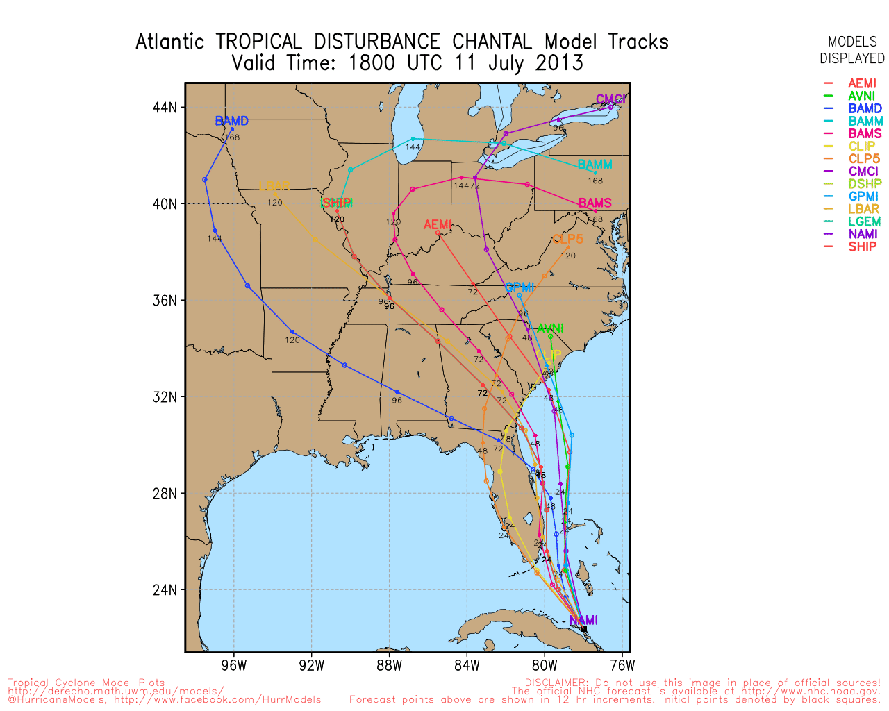
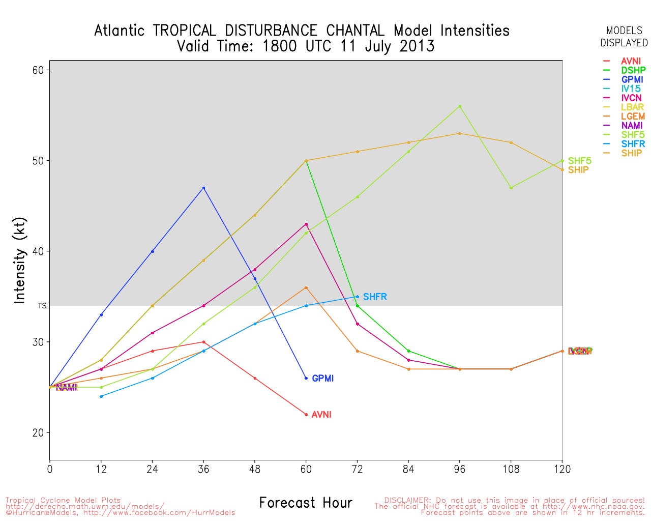
2:25 PM EDT 11 July 2013 Update
Chantal's remnants have split, one over southern Cuba, and the other north of Hispaniola, the area as a whole has a 30% chance to redevelop, so it'll remain worth watching for a bit.
7:30 AM EDT 11 July 2013 Update
Chantal's fast forward motion and shear and the influence of a destroyed the core of the system as it neared Hispaniola. Recon could not find a center. It appears most of the remnant will likely stay east of Florida for the most part.
It is bringing heavy rain to Haiti and the Dominican Republic, however.
There are very low chances it could regenerate, but it will be watched just in case.
8:00 AM EDT 10 July 2013 Update
Tropical Storm Chantal fell apart greatly overnight, and recon was barely able to find any winds, it's almost an open wave at this point, however there is still some convection firing around the center this morning that will keep it alive at least through the morning. If the convection persists it may hold on as a weak storm or depression in the near term. If not, it will likely be dropped.
Recon is en route now to check up on Chantal, and if it can't find a center, watches and warnings will likely be discontinued.
Partially because of the weaker system and strong ridging to the north it continues to move west north west as a rapid 29mph, and the forecast track has shifted westward,
If Chantal does fall apart the remnants will likely bring some rain to Florida, and Haiti and the Dominican Republic will see rain regardless.
8:30 PM EDT 9 July 2013 Update
Tropical Storm Chantal surprised a few folks today when it got up to 65MPH winds per Recon. Currently another recon flight is out in the storm, but has not found winds like that yet, as some of the convection around the system collapsed earlier this afternoon. At quick glance, it appears to have weakened since earlier in the day.
Convection still is firing around the center of Chantal, so the system is still alive. The forecast takes it right over the middle of Hispaniola, with the dirty side mostly in the Dominican Republic. Going over the island will likely take a punch out of Chantal. Beyond that, the forecast cone gets very uncertain, as a lot depends on how far west Chantal makes it before turning north.
Even then, the ridge may build back in and kick the storm westward at whatever point it is. At the least it'll be a rainmaker for someone along the east coast from Florida up to the Carolinas.
In the short term, though. Tropical Storm Warnings are still up for Puerto Rico, the Dominican Republic, Haiti, Turks and Caicos, and the southeastern Bahamas. Hurricane Watches are up as a precaution in case Chantal strengthens more before landfall in the Dominican Republic tomorrow afternoon.

Model runs have been a bit back and forth today, and seem to be having some trouble with the fast movement of the storm. The hurricane center's track (and especially cone area) seems good, however. This cone includes most of Florida, Coastal Georgia, South Carolina, and Southeastern North Carolina, so it will need to be watched in that area. Because of the fast forward motion, Chantal could be east of Florida Saturday.
7AM EDT 9 July 2013 Update
Tropical Storm Chantal is a bit more ragged in appearance this morning but the center is easily seen on Barbados radar.
A tropical storm warning continues for many of the eastern Caribbean Islands as well as Puerto Rico and the southern Dominican Republic coast.
It's still moving quickly toward the west northwest and this is expected to continue for the next day and a half as it rides along the ridge.
The track takes it over the Dominican Republic Wednesday late afternoon into Thursday morning, and brings up some Flooding concerns for Haiti as well, the positive note is that it still will likely be moving fairly quickly, albeit a bit slower. The mountains three will likely weaken, if not destroy, Chantal.
The low currently near the Bahamas is likely what will cause the ridge to break down enough for it to allow Chantal to move more northward, but with some models indicating it will quickly build back up and basically trap Chantal near the Bahamas.
After this it depends on how strong the ridge is, but it appears it may be strong enough to kick the storm back to the west toward Florida or the Southeast Sunday into Monday. all this greatly depends on the exact timing of the storm. Even if the storm does not survive, the remnant could bring much rain to Florida.
Even though the official forecast shows strengthening while Chantal is in the Caribbean, in the past many systems entering the east Caribbean struggle, but it is likely to stay organized through that. Some of the models lose Chantal after crossing Hispaniola, which would be the best outcome.
In short those along the east coast of Florida and parts of the Southeast US will want to keep close watch on Chantal to see what occurs.
Beyond this, a few more waves in the Atlantic will likely be worth watching later.

Original Update
Tropical Storm Chantal continues to move toward the Caribbean at a fairly fast rate of 26mph toward the west northwest.
Because of the speed, Tropical Storm warnings are up for Barbados, Dominica, St. Lucia, Martinique, Guadeloupe, Puerto Rico, and southern coast of the Dominican Republic.
Additionally Tropical storm watches are up for the Virgin Islands, St. Vincent, Vieques and Culebra, the northern coast of the Dominican Republic, and all of Haiti.
Once past Haiti the official forecast takes it into the Bahamas as a tropical depression after being torn up by the mountains. However, if the system remains intact, it does have more favorable conditions near the Bahamas for development.
The current pressure vs wind ratio is mainly due to it being embedded in a ridge, it's not typical to see a 50MPH tropical storm with such high pressures otherwise.
Although a lot could change over the next few days, the fast forward motion, along with land interaction will most likely keep Chantal weak, It is still slightly more likely that it will stay east of Florida,but it cannot be ruled out at this time since some of the models show a collapse in steering currents over the Bahamas, which means we in Florida will need to watch this one very closely, as well as the Bahamas and the islands in the watch/warnings area Other waves east of Chantal will need to be watched later on.
Barbados Radar Chantal Approach Recording
(Alt Style)
|
LoisCane
Veteran Storm Chaser

Reged:
Posts: 1236
Loc: South Florida
|
|
Watches and warnings are up for a large portion of the Caribbean tonight. New information as the models come in this evening with the new information from recon today will help pin down more details on the end game.
Like to see data from the Gulfstream Jet sampling the air as well.
Those waves behind Chantal are worth noting.
Either way flooding from a strong Tropical Storm or any Tropical Storm can do much damage over Haiti especially as the hillsides slide down with little to hold them together.
--------------------
http://hurricaneharbor.blogspot.com/
|
danielw
Moderator

Reged:
Posts: 3525
Loc: Hattiesburg,MS (31.3N 89.3W)
|
|
Circulation appears to be intact after passing over Barbados.
Latest Vortex. 1218Z or 8:18 AM EDT
Product: Air Force Vortex Message (URNT12 KNHC)
Transmitted: 9th day of the month at 12:18Z
Aircraft: Air Force Aircraft (Last 3 digits of the tail number are 302)
Storm Number & Year: 03L in 2013
Storm Name: Chantal (flight in the North Atlantic basin)
Mission Number: 2
Observation Number: 03
A. Time of Center Fix: 9th day of the month at 12:04:10Z
B. Center Fix Coordinates: 13°52'N 60°19'W (13.8667N 60.3167W)
B. Center Fix Location: 46 miles (74 km) to the ESE (102°) from Castries, Saint Lucia.
C. Minimum Height at Standard Level: Not Available
D. Estimated (by SFMR or visually) Maximum Surface Wind: 52kts (~ 59.8mph)
E. Location of the Estimated Maximum Surface Wind: 25 nautical miles (29 statute miles) to the N (356°) of center fix
F. Maximum Flight Level Wind Inbound: From 80° at 64kts (From the E at ~ 73.6mph)
G. Location of Maximum Flight Level Wind Inbound: 25 nautical miles (29 statute miles) to the N (358°) of center fix
H. Minimum Sea Level Pressure: 1003mb (29.62 inHg) - Extrapolated
I. Maximum Flight Level Temp & Pressure Altitude Outside Eye: 21°C (70°F) at a pressure alt. of 391m (1,283ft)
J. Maximum Flight Level Temp & Pressure Altitude Inside Eye: 23°C (73°F) at a pressure alt. of 363m (1,191ft)
K. Dewpoint Temp (collected at same location as temp inside eye): 23°C (73°F)
K. Sea Surface Temp (collected at same location as temp inside eye): Not Available
L. Eye Character: Not Available
M. Eye Shape: Not Available
N. Fix Determined By: Penetration, Wind and Temperature
N. Fix Level: 1,500 feet
O. Navigational Fix Accuracy: 0.02 nautical miles
O. Meteorological Accuracy: 2 nautical miles
Remarks Section:
Maximum Flight Level Wind: 64kts (~ 73.6mph) which was observed 25 nautical miles (29 statute miles) to the N (358°) from the flight level center at 11:52:00Z emphasis added~danielw
Sea Level Pressure Extrapolation From: Below 1,500 feet
Maximum Flight Level Temp: 24°C (75°F) which was observed 7 nautical miles to the NNE/NE (34°) from the flight level center
Edited by danielw (Tue Jul 09 2013 12:42 PM)
|
danielw
Moderator
Reged:
Posts: 3525
Loc: Hattiesburg,MS (31.3N 89.3W)
|
|
I'm seeing a great deal of data from RECON that is suggesting the wind speeds are near Hurricane Force at flight level.
Interesting to see what happens after Chantal passes over St Vincent.
|
danielw
Moderator
Reged:
Posts: 3525
Loc: Hattiesburg,MS (31.3N 89.3W)
|
|
Product: Air Force Vortex Message (URNT12 KNHC)
Transmitted: 9th day of the month at 13:08Z
Aircraft: Air Force Aircraft (Last 3 digits of the tail number are 302)
Storm Number & Year: 03L in 2013
Storm Name: Chantal (flight in the North Atlantic basin)
Mission Number: 2
Observation Number: 06
A. Time of Center Fix: 9th day of the month at 12:57:20Z
B. Center Fix Coordinates: 13°56'N 60°42'W (13.9333N 60.7W)
B. Center Fix Location: 20 miles (31 km) to the ESE (104°) from Castries, Saint Lucia.
C. Minimum Height at Standard Level: Not Available
D. Estimated (by SFMR or visually) Maximum Surface Wind: 55kts (~ 63.3mph)
E. Location of the Estimated Maximum Surface Wind: 42 nautical miles (48 statute miles) to the ENE (62°) of center fix
F. Maximum Flight Level Wind Inbound: From 118° at 70kts (From the ESE at ~ 80.6mph)
G. Location of Maximum Flight Level Wind Inbound: 47 nautical miles (54 statute miles) to the ENE (60°) of center fix
H. Minimum Sea Level Pressure: 1010mb (29.83 inHg) - Extrapolated
I. Maximum Flight Level Temp & Pressure Altitude Outside Eye: 20°C (68°F) at a pressure alt. of 364m (1,194ft)
J. Maximum Flight Level Temp & Pressure Altitude Inside Eye: 23°C (73°F) at a pressure alt. of 366m (1,201ft)
K. Dewpoint Temp (collected at same location as temp inside eye): 23°C (73°F)
K. Sea Surface Temp (collected at same location as temp inside eye): Not Available
L. Eye Character: Not Available
M. Eye Shape: Not Available
N. Fix Determined By: Penetration, Wind, Pressure and Temperature
N. Fix Level: 1,500 feet
O. Navigational Fix Accuracy: 0.02 nautical miles
O. Meteorological Accuracy: 2 nautical miles
Remarks Section:
Maximum Flight Level Wind: 70kts (~ 80.6mph) which was observed 47 nautical miles (54 statute miles) to the ENE (60°) from the flight level center at 12:41:00Z
Sea Level Pressure Extrapolation From: Below 1,500 feet
|
MikeC
Admin
Reged:
Posts: 4544
Loc: Orlando, FL
|
|
I see that too (with recon), Chantal may be slowing down a bit, giving it a chance to catch up. Supports a 60MPH storm at least, still with a fairly high pressure at 1010mb (but still relatively low compared to the high around it).
|
MikeC
Admin
Reged:
Posts: 4544
Loc: Orlando, FL
|
|
Scratch that, second vortex Message shows a pressure of 1003mb, now that makes a bit more sense.
|
Hawkeyewx
Weather Analyst
Reged:
Posts: 99
|
|
Chantal could get interesting later on if it holds together, but right now it's struggling a bit with some modest dry air and shear. The satellite appearance is not pretty. There has never been more than light west wind on the south side of the center so it wouldn't take much weakening to drop it down to an open wave.
|
danielw
Moderator
Reged:
Posts: 3525
Loc: Hattiesburg,MS (31.3N 89.3W)
|
|
NHC has bumped the wind speed up to 60 MPH after Chantal 'shot the CATL gap' and has moved into the Eastern Caribbean.
TROPICAL STORM CHANTAL DISCUSSION NUMBER 7
NWS National Hurricane Center MIAMI FL AL032013
1100 AM AST TUE JUL 09 2013
THE SATELLITE PRESENTATION IS NOT DISTINCT BUT EXCELLENT RADAR DATA
FROM BARBADOS AND MARTINIQUE SHOW THE WELL-DEFINED CENTER OF
CHANTAL MOVING RAPIDLY WESTWARD ABOUT 25 KNOTS BETWEEN MARTINIQUE
AN ST. LUCIA. A RECONNAISSANCE PLANE REPORTED FLIGHT LEVEL WINDS OF
70 TO 75 KT NORTHEAST OF THE CENTER EARLIER TODAY WITH A MINIMUM
PRESSURE OF 1003 MB. SINCE THAT TIME...THE PRESSURE HAS LEVELED OFF
TO ABOUT 1006 MB. BASED ON MORE REPRESENTIVE OBSERVATIONS FROM THE
PLANE...AND SURROUNDING ISLANDS...THE INITIAL INTENSITY IS SET AT 50
KNOTS. THE ENVIRONMENT AHEAD OF CHANTAL IS NOT VERY FAVORABLE FOR
INTENSIFICATION...AND ONLY A SLIGHT INCREASE IN THE WINDS IS
FORECAST BEFORE CHANTAL CROSSES HISPANIOLA. THE UPPER-LEVEL WINDS
ARE FORECAST TO REMAIN UNFAVORABLE IN THE AREA OF THE BAHAMAS FOR
SIGNIFICANT DEVELOPMENT...AND ONLY SMALL STRENGTHENING IS
ANTICIPATED AFTER THE CYCLONE CROSSES HISPANIOLA. THIS IS IN
AGREEMENT WITH THE TREND OF THE SHIPS/LGEM MODELS.
CHANTAL IS RACING TOWARD THE WEST-NORTHWEST OR 295 DEGREES AT 25
KNOTS. I AM SURPRISED THE SYSTEM EVEN HAS A CLOSED CIRCULATION
MOVING AT THAT SPEED.... edited~danielw
Forecaster Avila
Edited by danielw (Tue Jul 09 2013 03:10 PM)
|
Ed Dunham
Former Meteorologist & CFHC Forum Moderator (Ed Passed Away on May 14, 2017)
Reged:
Posts: 2565
Loc: Melbourne, FL
|
|
TS Chantal has strengthened and now is in the eastern Caribbean Sea. I did notice a wind gust to 53mph on Martinique at 10:30AST. Satellite and radar hint at a bit of a jog more to the west - which is not uncommon as storms 'lift' over the northeast portion of South America. The west northwest motion is likely to resume in a few hours.
ED
|
typhoon_tip
Meteorologist
Reged:
Posts: 576
|
|
Looks precariously close to dissolving into an open wave through satellite observation. There are cold cloud top convective plumes still prevalent, it's just that the cyclonic "appearance" is less convincing at the moment.
Note: Climatologically, this part of the eastern Caribbean tends to be tough on younger TC's, for whatever physical processes aside. If perhaps that is playing out here, seeing some degeneration does have a bit of a statistical precedence. For one thing, TCs tend to struggle when they are moving so quickly. Perhaps TCs in this lat/lon tend to be fast movers. Whatever the reason, SAL, OHC, and shear do not appear to be negative factors.
In any case, relying on RECON, radar and surface obs are always better than the tendency for satellite presentations to tell giant lies... And likewise, these are still showing impressive signatures.
|
scottsvb
Weather Master
Reged:
Posts: 1184
Loc: fl
|
|
That wind shear over Jamaica doesn't look good for Chantel.......I think she has 12hrs to get better organized before Hispaniola by mid day Weds.
|
berrywr
Weather Analyst

Reged:
Posts: 387
Loc: Opelika, AL
|
|
This is a graphic I posted on our Facebook page; Chantal while earlier today may have become a hurricane; it's barely holding together. What strong winds there are are confined to a fairly small space and even smaller this evening as Chantal has come in weaker and it may in fact be an open wave.
NOAA AOML
--------------------
Sincerely,
Bill Berry
"Survived Trigonometry and Calculus I"
Edited by berrywr (Wed Jul 10 2013 03:39 AM)
|
typhoon_tip
Meteorologist
Reged:
Posts: 576
|
|
It's the bewitching hour for Chantal. As we suggested earlier, now TPC has reported RECON the same:
"THE SATELLITE PRESENTATION OF CHANTAL BECAME LESS ORGANIZED DURING
THE LATE AFTERNOON AND EARLY EVENING...BUT THERE HAS BEEN A BURST
OF DEEP CONVECTION RECENTLY NEAR THE ESTIMATED CENTER. THE PLANE HAS HAD DIFFICULTY FIXING A CENTER...WITH THE WIND FIELD RESEMBLING AN OPEN WAVE RATHER THAN A CLOSED CIRCULATION.
We did have some internal discussion about the causes for TCs to struggle in the eastern Caribbean. It is not entirely clear if those reason are inflicting the tropical storm, but if this does indeed dissolve it will be interesting to discuss why.
Edited by typhoon_tip (Wed Jul 10 2013 05:28 AM)
|
cieldumort
Moderator

Reged:
Posts: 2305
Loc: Austin, Tx
|
|
Chantal has been tenacious given its forward speed, but it appears likely to me tonight that owing to pre-exisiting lower surface pressures in the southern Caribbean, Chantal has been robbed of sufficient pressure gradient, such that its internal vorticity gave up the ghost. It's my opinion that if there is a closed low associated with Chantal, it no longer exists at the surface, or is fleeting, at best.
If Chantal is indeed now an open wave, while may continue advisories on "Chantal" because of its history of on again/off again, primarily open wave Chantal could kink all the forecasts calling for a tropical storm to run up the east coast of Florida. The possibility now increases that a potent wave sneaks across the Caribbean, perhaps to find a second life in the northwestern Carib, or even the GOM.
|
typhoon_tip
Meteorologist
Reged:
Posts: 576
|
|
Tend to agree there; this part of the Caribbean is not very favorable for TC's, particularly those that are in the formulation phase. There are multiple reasons why.
It's a vigorous wave if indeed it does open up, and that would mean a more westerly track to consider.
|
OrlandoDan
Weather Master

Reged:
Posts: 443
Loc: Longwood, FL
|
|
I believe Chantal will take a more westerly track now that she is basically an open wave. if she holds together, there may be a chance that she intensifies once north or west of Cuba. I believe the track will shift to the west as the day goes on.
|
Ed Dunham
Former Meteorologist & CFHC Forum Moderator (Ed Passed Away on May 14, 2017)
Reged:
Posts: 2565
Loc: Melbourne, FL
|
|
From RECON:
URNT11 KNHC 101414
97779 14120 40171 71819 07700 06040 19//9 /9797
RMK AF301 0503A CHANTAL OB 07
SWS = 37 KTS
Well the winds are still there (barely) in the northeast quad. I guess we'll know shortly if its an open or closed system.
ED
|
LoisCane
Veteran Storm Chaser
Reged:
Posts: 1236
Loc: South Florida
|
|
Wrote a long post today about the pluses and minuses of Chantal's very existence and future. If you make a spreadsheet of pros and cons logically it should never have gotten this far nor should it still be there firing up this morning on the floater as if it is sending up red flares for the to find it. Easily found..go figure.
Positives
1) Her tenancity of existing and making it across the ocean in Early July from an early CV wave which is usually one that "wets up the atmosphere for future waves" and nothing more. Upgraded in the Atlantic and still there in the Eastern Caribbean the "graveyard of storms" and not dying is her main positive point in her favor.
Negatives
1) Extremely fast forward speed. When was the last time a storm didn't go less than 25 MPH forward speed ever? And, last night it was trucking at 30 mph forward speed...which is more than many naysayers feel her winds were last night.
2) Shear...always there...that's why we call it the "graveyard of storms"
3) SAL and dry air she developed in and has been traveling with for days.
4) CLIMO
Any balance sheet would easily say she should not be there at all ....and yet she is..
Recon found enough data to keep her as a weak Tropical Storm with a cone that continues to call South Florida's name and yet...she is moving west still very rapidly. A very complicated storm to work with and model output isn't always helpful and the is doing the best it can and that's pretty good in my opinion with this storm. LOCATION...16.5N 72.0W
ABOUT 335 MI...535 KM ESE OF KINGSTON JAMAICA
ABOUT 145 MI...235 KM S OF PORT AU PRINCE HAITI
MAXIMUM SUSTAINED WINDS...45 MPH...75 KM/H
PRESENT MOVEMENT...W OR 280 DEGREES AT 29 MPH...46 KM/H
MINIMUM CENTRAL PRESSURE...1011 MB...29.85 INCHES
http://www.nhc.noaa.gov/refresh/graphics_at3+shtml/145859.shtml?5day#contents
Worth noting the mets in NC have been saying we would see moisture from Chantal all morning..seems they buy into that general forecast cone.
--------------------
http://hurricaneharbor.blogspot.com/
|
ftlaudbob
Storm Chaser

Reged:
Posts: 828
Loc: Valladolid,Mx
|
|
As of 2:00 it is still a TS,but barely.From the .
MAXIMUM SUSTAINED WINDS ARE NEAR 45 MPH...75 KM/H...WITH HIGHER
GUSTS. THESE WINDS ARE CONFINED TO THE NORTH AND EAST OF THE
CENTER. DATA FROM A RECONNAISSANCE PLANE CURRENTLY INVESTIGATING
CHANTAL SUGGEST THAT THE CYCLONE IS DEGENERATING INTO A TROPICAL
WAVE.
--------------------
Survived: 10 hurricanes in Rhode Island,Florida and the Yucatan of Mexico .
|


 Threaded


