MikeC
Admin
Reged: Sun
Posts: 4543
Loc: Orlando, FL
|
|
8:58 AM EDT 2 October 2013 Update
Jerry Continues to be mostly stationary, but movement toward the northeast is still expected in the few days.
The area in the northwest Caribbean will be under some of the best conditions it will have over today and tomorrow, so if it develops, it likely would be tonight or tomorrow. Those along the Central to Northeastern Gulf will want to watch this, but even if it develops, this system likely will be mostly a rain event.
Aircraft recon is scheduled to check out the Caribbean system this afternoon.
Radar Recording of 97L approach to Cancun ( Alternate Animator )
Northeast Gulf Links
Southeast Composite Radar Loop
(Latest Static)
Tampa Bay, FL Radar Radar Loop
(Latest Static)
Key West, FL Radar Radar Loop
(Latest Static)
Mobile, AL Radar Radar Loop
(Latest Static)
Tallahassee FL Radar Radar Loop
(Latest Static)
Northwest Florida Radar Radar Loop
(Latest Static)
Gulf of Mexico Satellite Imagery
SFWMD Full Florida Radar (Includes east LA, MS,AL) Loop with Storm Track
Area Forecast Discussions:
New Orleans -
Mississippi/Alabama/Pensacola -
Panhandle/Tallahassee -
Tampa/West Central Florida
StormCarib Reports from the Caribbean Islands
Caribbean Weather Observations
Barbados Brohav Weather Fax
Full Caribbean Radar Composite
Caribbean Broadcast Corporation (TV/Radio from Antilles)
San Juan, PR NWS Page
Various Caribbean Radio Stations
DR1 Dominican Republic Hurricanes
Original Update
October has arrived in this relatively quiet year in the Atlantic Tropics. With Tropical Storm Jerry stationary for a while, but expected to move northeast later in the week.
97L in the Western Caribbean has somewhat of a chance to develop later in the week, about 50/50 shot then, but conditions ahead of it don't really support much.
Odds favor this system being sheared apart and bringing rainfall to the northeast Gulf and Florida, still the next day or so will tell if the chances increase for some development before then.
The best chance for development is while it's still in the northwest Caribbean or extreme southern Gulf. Once in the central Gulf, the system likely will weaken when it nears land because of increasing shear.
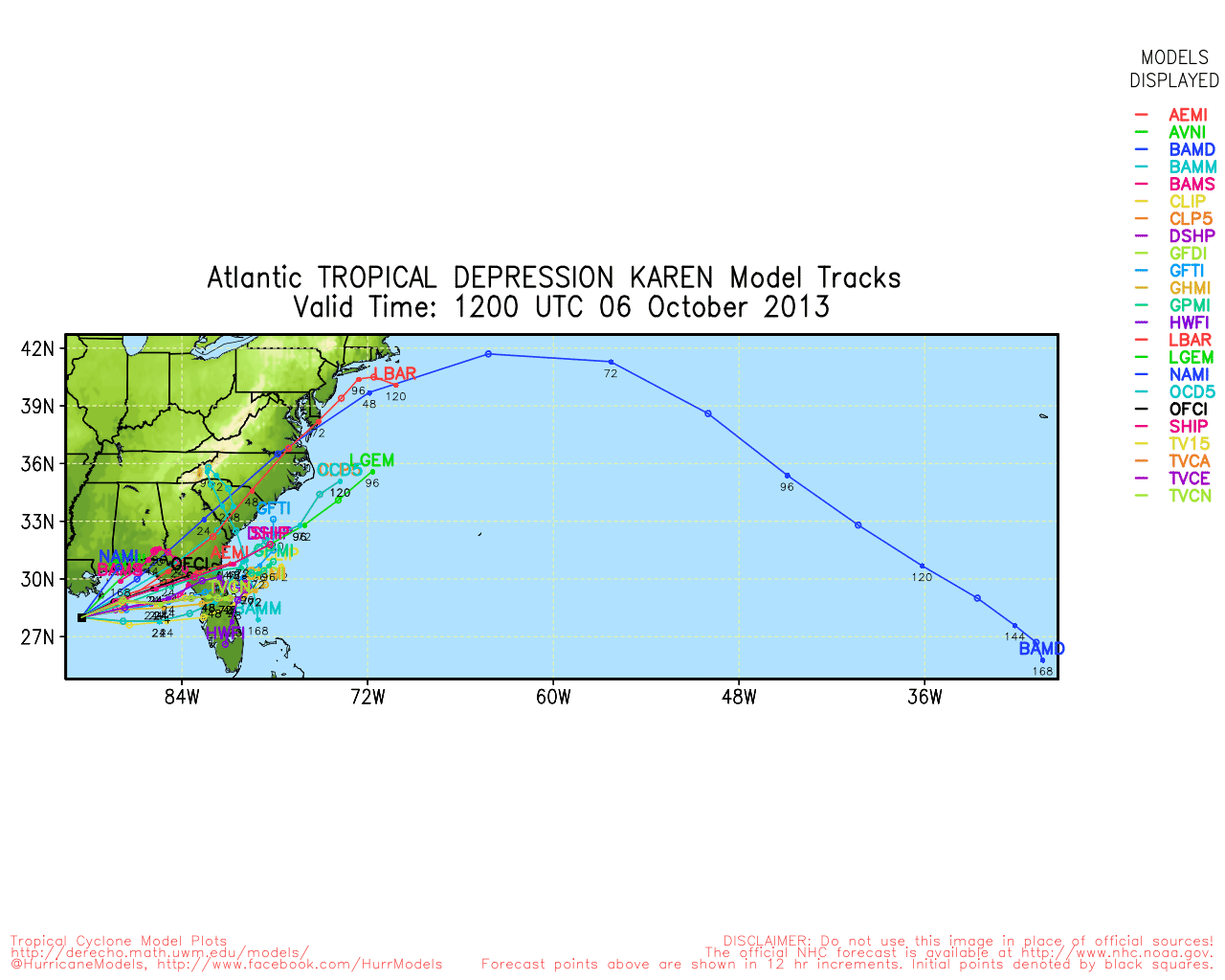
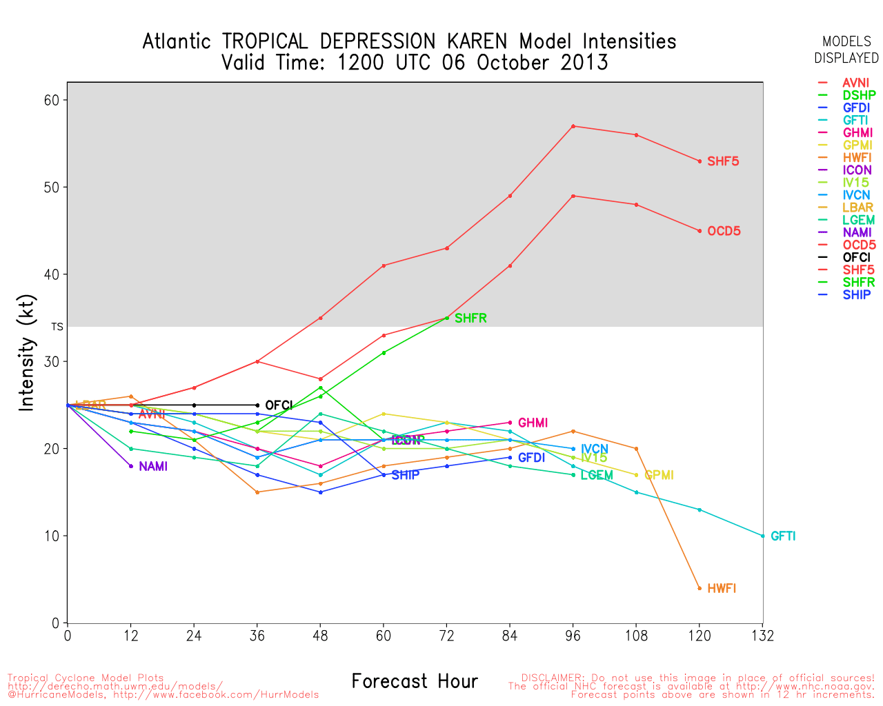
Karen Event Related Links


SFWMD Model Plot (Animated Model Plot) SFWMD Hurricane Page
[https://flhurricane.com/floatanimator.php?year=2013&storm=12 Flhurricane Satellite Floater Animation of Karen
GOES Floater
Animated Model Plot of Karen
Clark Evans Track Model Plot of Karen
(Animated!) Model Plots in Google Earth - In Google Maps
Clark Evans Intensity Model Plot of Karen (Animated!)
Clark Evans Track Plot of Karen
Other Model Charts from Clark
Clark Evans Top 10 Analog Storms for Karen
More model runs on from RAL/Jonathan Vigh's page
NRL Info on Karen -- RAMMB Info
COD Atlantic Satellite View
(Note: isn't updating properly on invests, the graphic above does not represent 97L's current position)
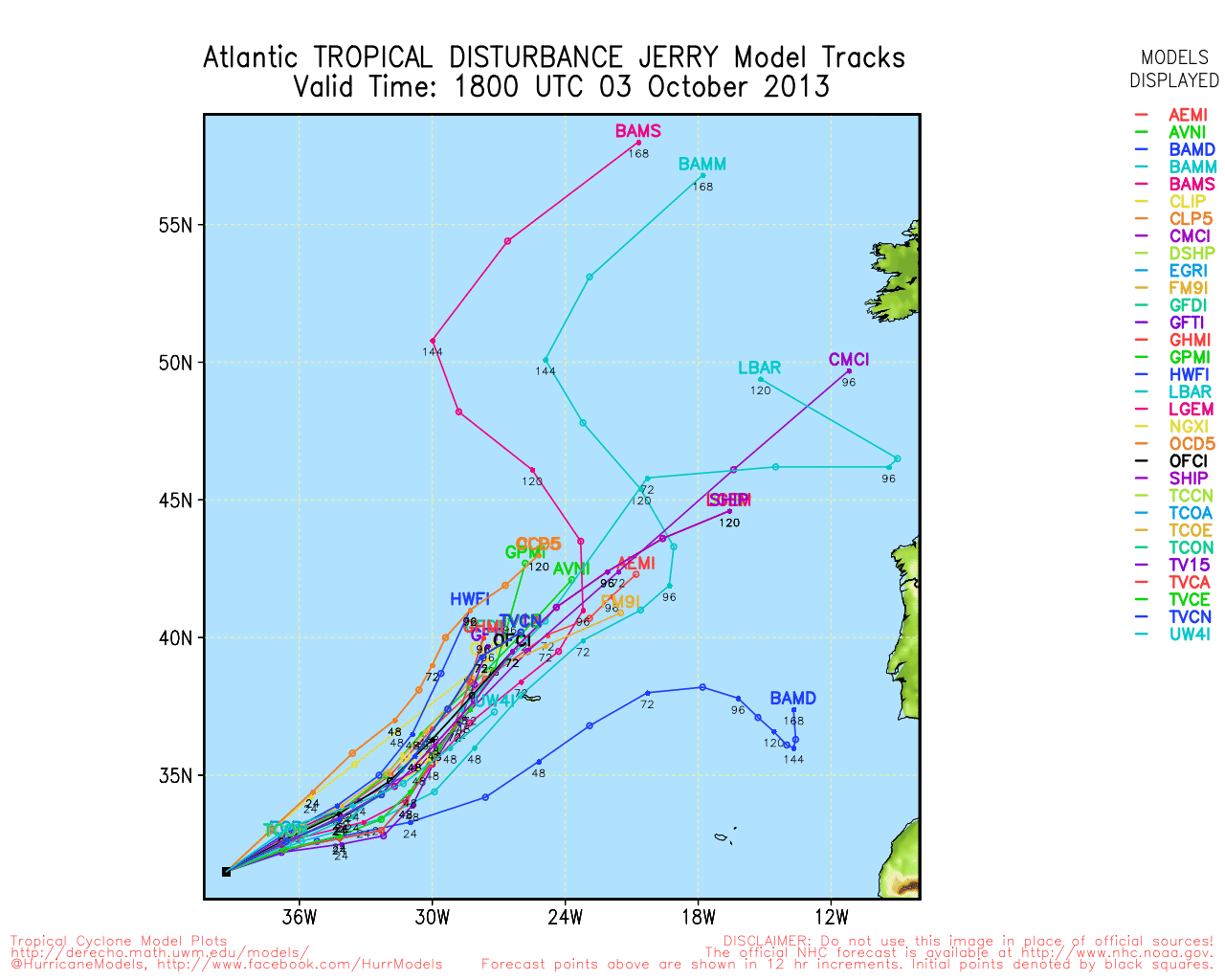
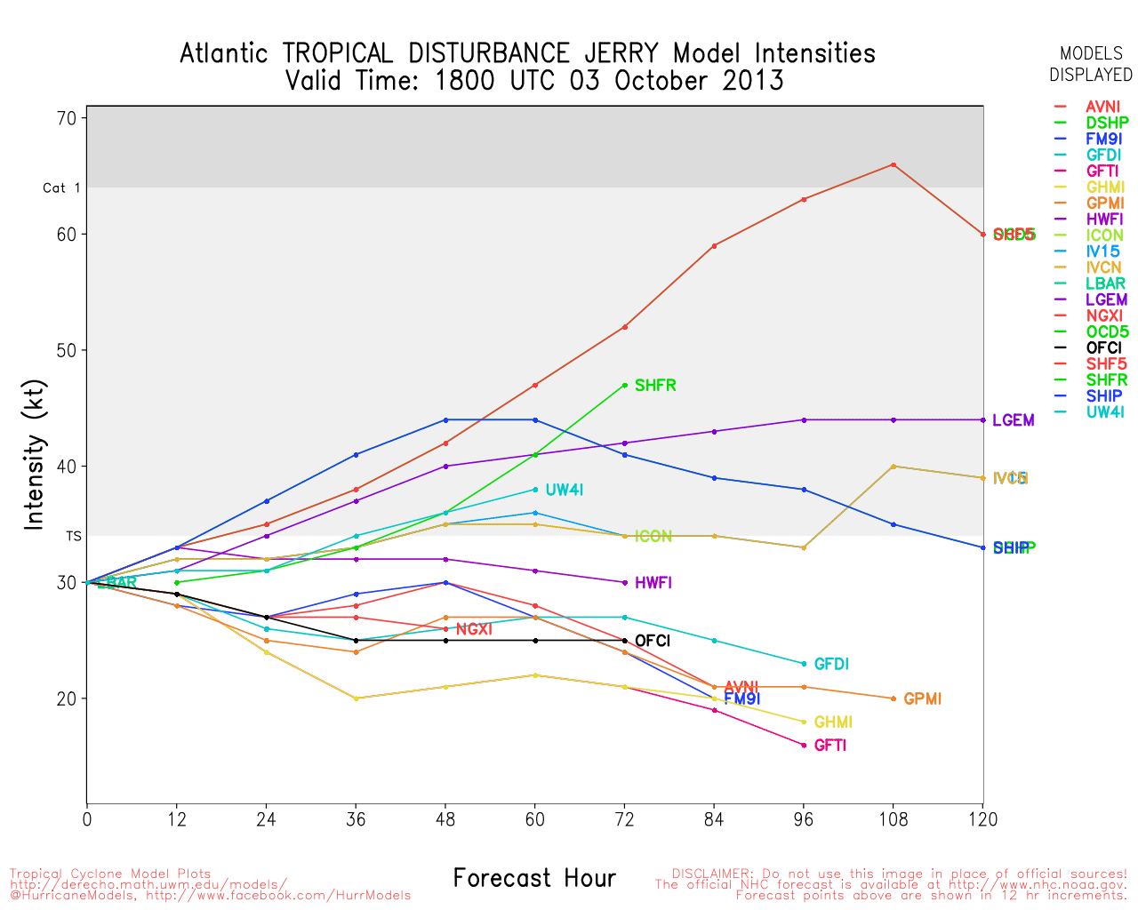
Jerry Event Related Links


SFWMD Model Plot (Animated Model Plot) SFWMD Hurricane Page
[https://flhurricane.com/floatanimator.php?year=2013&storm=11 Flhurricane Satellite Floater Animation of Jerry
GOES Floater
Animated Model Plot of Jerry
Clark Evans Track Model Plot of Jerry
(Animated!) Model Plots in Google Earth - In Google Maps
Clark Evans Intensity Model Plot of Jerry (Animated!)
Clark Evans Track Plot of Jerry
Other Model Charts from Clark
Clark Evans Top 10 Analog Storms for Jerry
More model runs on from RAL/Jonathan Vigh's page
NRL Info on Jerry -- RAMMB Info
COD Atlantic Satellite View
|
M.A.
Weather Guru
Reged: Thu
Posts: 108
Loc: Vero Beach, Fl
|
|
97L looks much more organized today. Out flow seems to be starting on the northern side. The looks to almost be covering the center of circulation. Most of the models as of this morning keep it weak through landfall, hopefully they are correct.
|
scottsvb
Weather Master
Reged: Mon
Posts: 1184
Loc: fl
|
|
Can we plz post and do the timelapse radar out of cancun plz....thanks 
|
Wingman51
Weather Guru

Reged: Tue
Posts: 126
Loc: Orlando, FL
|
|
With the government shut down - - what NOAA services will be disrupted re Invest 97L? 
|
Lamar-Plant City
Storm Tracker

Reged: Mon
Posts: 383
Loc: Plant City, Florida
|
|
They have upped the probability on this one to 70% and the models seem to be getting a better handle on it. There is a lot more agreement that it will traverse the central GOM, then get caught up in a trough and swing to the ENE into the panhandle. I would still only give that a moderate probability overall but there is a lot more going today...
--------------------
If you don't like the weather, wait 5 minutes...
2023 Season Prediction: 17/6/2
|
MikeC
Admin
Reged: Sun
Posts: 4543
Loc: Orlando, FL
|
|
Quote:
Can we plz post and do the timelapse radar out of cancun plz....thanks
Nothing really there right now, but this one has a real shot for development
Radar Recording of 97L Cancun Approach ( Alternate Animator )
Recon is finding a rather broad area of low pressure right now, slightly higher winds, but not enough for development right now.
|
MichaelA
Weather Analyst

Reged: Thu
Posts: 945
Loc: Pinellas Park, FL
|
|
Satellite presentation is beginning to look fairly impressive, though. The models seem to be indicating a TS impacting the northern Gulf Coast in a couple of days.
--------------------
Michael
PWS
|
cieldumort
Moderator

Reged: Mon
Posts: 2305
Loc: Austin, Tx
|
|
As of 5:45PM EDT, recon looks very close to being able to close 97L off. In addition to the circulation becoming better defined, the deepest convection has recently been firing right near or even on top of the approximate center of circulation. We could easily have TWELVE or Karen declared tonight. It's almost a lock, IMHO.
|
MichaelA
Weather Analyst
Reged: Thu
Posts: 945
Loc: Pinellas Park, FL
|
|
If it is declared a TS, then the models will have a definite initialization data point and set, so subsequent runs will be much more reliable. Of course, with a stronger initial intensity, I wonder what the intensity forecasts will become.
--------------------
Michael
PWS
|
scottsvb
Weather Master
Reged: Mon
Posts: 1184
Loc: fl
|
|
We will have a decent idea after the 12Z runs on Thurs on where this might go. Right now it's the panhandle of florida but they are very quick to put 97L 100 miles north of the Yucitan by 15Z on Thurs near 88W almost.. They might be alittle too fast
|
M.A.
Weather Guru
Reged: Thu
Posts: 108
Loc: Vero Beach, Fl
|
|
The last frame of the Visible sat looks like a nice cold tower right over the COC is currently flaring up. I will be surprised if we do not have an upgrade straight to TS at the 8pm.
|
Ed Dunham
Former Meteorologist & CFHC Forum Moderator (Ed Passed Away on May 14, 2017)
Reged: Sun
Posts: 2565
Loc: Melbourne, FL
|
|
Satellite presentation continues to improve. Cozumel and Cancun now both reporting a light west wind so the low seems to have closed off.
ED
|
OrlandoDan
Weather Master

Reged: Mon
Posts: 443
Loc: Longwood, FL
|
|
Asof 0628 EDT, Gulf of Mexico satelitte AVN loop seems to be reflecting a slight enlragement of the system with a slight elongation from north to south. Coldest cloud tops also seems to be blowing off to the northeast. It is too soon to say if there is more of an eastward componenet, but it is worth keeping an eye on.
--------------------
Keith (1988), Charley (2004), Frances (2004) , Jeanne (2004), Fay (2008), Mathew (2016), Irma (2017), Dorian (2019)
Personal Weather Station: https://www.wunderground.com/dashboard/pws/KFLLONGW67
|


 Threaded


