11PM EDT Update 17 October 2014

Gonzalo passing over Bermuda, and some of the strongest winds have been on the back eye wall.
From the discussion:
The following information is provided at the request of the Bermuda
Weather Service -- damage to the old and new hospitals has been
reported, the AWOS weather sensors at the Bermuda International
Airport have been damaged due to saltwater inundation and are
inoperable, and the RCC Bermuda Radio Maritime Operations Center at
St. Georges has been damaged and is inoperable.
7AM EDT Update 17 October 2014
Hurricane Gonzalo is approaching bermuda tonight and if it maintains the forecast may bring approx 10 ft of storm surge to the island as well as extremely strong winds. Bermuda seems relatively well prepared for the system, but the worst should be late this afternoon into the early evening there.

Bermuda Newspapers/Media:
BerNews
Royal Gazette (Bermuda)
Bermuda Sun
Hott 107.5 Bermuda Radio
Storm Carib Bermuda Reports
Bermuda Weather Service
Port Bermuda Webcam (IE only) Alternate Link to Port Bermuda Cam
Bermuda Radar Recording of Gonzalo approach
Hurricanetrack Tower Cam Recording of Gonzalo approach at Shelly Bay, Bermuda
Bermuda News Gonzalo Live STreams
Canadian Hurricane Centre
8AM EDT Update 15 October 2014
Gonzalo moved across the northern Leewards and is now forecast to move near or just west of Bermuda on Friday. A hurricane watch is up for Bermuda.
Gonzalo has become a category 3 major hurricane and has the chance to become a cat 4 before moving over colder waters and then a possible second landfall in southeastern Newfoundland.
Mark Sudduth from Hurricanetrack.com is heading out to Bermuda this morning.
5:25PM EDT Update 13 October 2014
Gonzalo is now a strengthening hurricane, and currently over St. Martin(French/North Side)/St. Maarten (Dutch/South Side) and nearing Anguilla. The system is in the process of rapidly strengthening now, as huge bursts of convection are now being seen near the eye of Gonzalo. Those in the islands it is directly passing over will need to stay indoors.
Beyond the islands, Bermuda may have to watch the track of Gonzalo.
4:45PM EDT Update 12 October 2014
Gonzalo has forced Hurricane Watches for the US Virgin Islands, Puerto Rico, Vieques, and Culebra. Also
Antigua and Barbuda.
From the National Hurricane Center's discussion, the system is already starting to develop an eye, which could be a signal of rapid intensification, therefore the hurricane watch area was expanded to include more. Those in the watch area please pay close attention, and prepare for the possibility of a storm stronger than forecast.

Fay has also been upgraded to a hurricane, but expected to weaken soon.
3:45PM EDT Update 12 October 2014
Tropical Storm Gonzalo has formed east of the Caribbean Leewards islands, and watches and warnings have been issued for:
Guadeloupe, Desirade, Les Saintes, Marie Galante, St. martin and St. Bathelemy, St. Maartin, Saba, St. Eustatius, Barbuda, Angilla, St. Kitts, Nevis, Montserrat, British and US Virgin Islands, and Peurto Rico.
Currently Gonzalo is forecast to be a hurricane as it approaches Puerto Rico, so that watch may be upgraded depending on the development of the system. In fact,with the system the way it currently is, I'd assume the watch for Puerto Rico and US Virgin Islands will be upgraded to a hurricane watch/warning later, so if you are in the area please prepare for that.
Beyond Peurto Rico, it is expected to stay out to sea, but may near Bermuda..
Those in the Watch/Warning areas will want to watch this system very closely, especially in Puerto Rico and the Virgin Islands. Mark Sudduth from Hurricanetrack.com will be out in Puerto Rico very soon.
Gonzalo is a small system, and can rapidly increase or decrease in strength,
Radar Recording of Antilles Radar of Gonzalo approach
Radar Recording of Barbados Radar of Gonzalo approach
StormCarib Reports from the Caribbean Islands
Caribbean Weather Observations
Barbados Brohav Weather Fax
Full Caribbean Radar Composite
Caribbean Broadcast Corporation (TV/Radio from Antilles)
San Juan, PR NWS Page
Various Caribbean Radio Stations
DR1 Dominican Republic Hurricanes
Original Update
The storm being tracked as Subtropical Storm #7 has strengthened rather rapidly this evening into the 60mph Subtropical Storm Fay. Not to be confused with Tropical Storm Fay of 2008, which affected Florida, especially east central Florida, with a great deal of rain. That one also had 3 Florida Landfalls and strengthened while over Lake Okeechobee. The name wasn't retired, so 6 years later it is in use again as this system.
This year's Fay is moving North Northwest is forecast to move just east of Bermuda, but close enough to Bermuda to cause a Tropical Storm Watch. With it likely having a large windfield as it nears, this may hold, even if the system does not go directly over Bermuda.
Outside of this, Invest 90L needs to be watched in the eastern Caribbean islands, but based on the pattern this time of year it is unlikely to have direct affects on the mainland US.
Bermuda Newspapers/Media:
BerNews
Royal Gazette (Bermuda)
Bermuda Sun
Hott 107.5 Bermuda Radio
Storm Carib Bermuda Reports
Bermuda Weather Service
StormCarib Reports from the Caribbean Islands
Caribbean Weather Observations
Barbados Brohav Weather Fax
Full Caribbean Radar Composite
Caribbean Broadcast Corporation (TV/Radio from Antilles)
San Juan, PR NWS Page
Various Caribbean Radio Stations
DR1 Dominican Republic Hurricanes
Gonzalo Event Related Links

SFWMD Model Plot (Animated Model Plot) SFWMD Hurricane Page
[https://flhurricane.com/floatanimator.php?year=2014&storm=8 Flhurricane Satellite Floater Animation of Gonzalo
GOES Floater
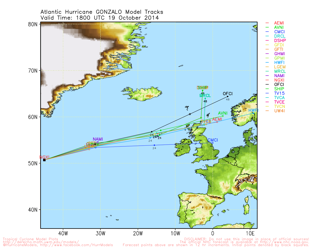
Animated Model Plot of Gonzalo
Clark Evans Track Model Plot of Gonzalo
(Animated!) Model Plots in Google Earth - In Google Maps
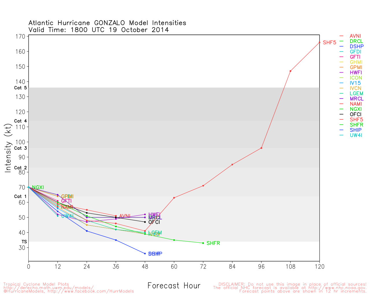
Clark Evans Intensity Model Plot of Gonzalo (Animated!)
Clark Evans Track Plot of Gonzalo
Other Model Charts from Clark
Clark Evans Top 10 Analog Storms for Gonzalo
More model runs on from RAL/Jonathan Vigh's page
NRL Info on Gonzalo -- RAMMB Info
COD Atlantic Satellite View


 Threaded


