MikeC
Admin
Reged: Sun
Posts: 4543
Loc: Orlando, FL
|
|
This it the lounge to discuss models, and guesses as to where the wave currently in the east Atlantic will go and how strong it may get. The topic will be renamed if it becomes an invest or named storm.
As of 2PM on July 1st the chances for development from the National Hurricane are 40%.
Only the is showing strong development right now, and misses it to the north of the Leeward Islands by a fair margin (18Z) and then near the Bahamas on July 13th. A category 4 hurricane over Jacksonville on the 16th, and and another landfall near Savannah, GA on the 17th.
The Euro has it weaker, although does develop it also, but keeps it well north of the leeward islands of the Caribbean as well.
None of the other models really develop it, which is good news now.
Based on the current trends it may develop, but is unlikely to directly impact land areas, however it's worth watching as the does have it over or close to the Bahamas in the long range, then a hurricane into Jacksonville on July 16th. Caveat for anyone new, models at that long of range are typically extremely inaccurate, but it does indicate that the system is worth watching.
As it crosses and when/if the system actually forms (and when other models start to latch onto it) is what to watch for. Persistence is the key with tropical systems. Until then the model runs are a curiosity.
Invest 94L has become TD FOUR and the title has been updated accordingly
-Ciel
Edited by cieldumort (Wed Jul 05 2017 11:10 PM)
|
MikeC
Admin
Reged: Sun
Posts: 4543
Loc: Orlando, FL
|
|
Morning model runs are much weaker, and a bit further west, The takes it over Florida now, but very weak. (rain event, and that's about it).
Parallel keeps it weak, and runs the northern Caribbean Islands starting July 9th, where it falls apart.
The 0z Euro is weak, it also has it over tha bahamas on July 12th. as well as the northern Leewards on July 9th Generally weak as well.
Canadian enters it right intot he Caribbean on July 9th.
Still plenty of time to watch this one, so I'm not terribly concerned about it now, something to watch,this coming weekend into the following week.
|
MikeC
Admin
Reged: Sun
Posts: 4543
Loc: Orlando, FL
|
|
The wave has been designated 94L, which will allow for more model runs and better info over the coming days.
18Z has backed off the US landfall, but keeps it strong.
Para keeps it weaker and moves it through the Bahamas.
Canadian takes it into the Bahamas as a hurricane (Run stops near the Abacos on July 12th)
Euro, has it weaker north of the Abacos at the end of the run on July 12th.
STill too far out to imply anything other than something to watch the first half of July.
94L (Eastern Atlantic Wave) Event Related Links

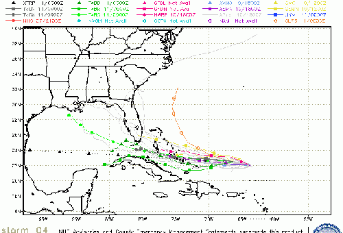
SFWMD Model Plot (Animated Model Plot) SFWMD Hurricane Page
[https://flhurricane.com/floatanimator.php?year=2017&storm=4 Flhurricane Satellite Floater Animation of 94L
GOES Floater
Animated Model Plot of 94L
Clark Evans Track Model Plot of 94L
(Animated!) Model Plots in Google Earth - In Google Maps
Clark Evans Intensity Model Plot of 94L (Animated!)
Clark Evans Track Plot of 94L
Other Model Charts from Clark
Clark Evans Top 10 Analog Storms for 94L
More model runs on from RAL/Jonathan Vigh's page
NRL Info on 94L -- RAMMB Info
COD Atlantic Satellite View
|
MikeC
Admin
Reged: Sun
Posts: 4543
Loc: Orlando, FL
|
|
Overnight model runs. (See "Forecast Models" on the left menu for more)
6Z is still running right now, but misses the Caribbean islands to the north and then bends back west. Further north than earlier runs. Closer to Bermuda. Starts bending it out to sea around 68.3 (west of Bermuda) then hooks it out to sea.
0Z Euro misses Caribbean islands to the north, bends back west toward July 12th (where the public run ends)
6z Parallel is MUCH weaker than the others, moves it much closer to the Caribbean islands, but the wave falls apart near there and remnants move north of the Caribbean.
0zCMC is slower than earlier runs, ends its run just northeast of the Bahamas on July 13th (Also misses Caribbean islands well to the north)
None of the models currently show landfall.
|
SouthGAwx
Verified CFHC User
Reged: Fri
Posts: 16
Loc: Georgia
|
|
Surface circulation isn't impressive -- but looks like a closed surface low does exists. Still very broad and somewhat elliptical.
Development not immediately likely, but beyond 36 hours or so, seems increasingly likely. Also, without getting too much into model discussion... there is something to be said about the run-to-run consistency of the UKMET for the past couple of days.
|
MikeC
Admin
Reged: Sun
Posts: 4543
Loc: Orlando, FL
|
|
Some of the midday (12z) runs show landfall in a few places now. (After not at all this morning)
12z is still out to sea, hooks around Bermuda
12z Euro takes it through the Northern Lesser Antilles on Saturday evening. Weakens it greatly and winds up over the Bahamas on
Parallel split it northeast of the Caribbean and then shoots along to the north and the other area brings some rain to Central Florida on July 14th. (not strong at all)
has a hurricane into Cape Canaveral late on July 12th.
This is a great example of how crazy the long range models are, and all that they are good for is indicating if something is worth watching. The ridging is what to watch in the longer range, rather than the position of the storm.
|
SouthGAwx
Verified CFHC User
Reged: Fri
Posts: 16
Loc: Georgia
|
|
Quote:
CMC has a hurricane into Cape Canaveral late on July 12th.
Mike -- Respectfully pointing out an error in the description above.
Take care,
-C.

|
MikeC
Admin
Reged: Sun
Posts: 4543
Loc: Orlando, FL
|
|
Yep I overstated the intensity, it was more a Ts/Depression but it did show landfall near Cape Canaveral late Tuesday evening (EDT).
18Z is further south/west by a good margin (500 miles or so) than the earlier run, and weaker, but loses it as a weak wave south of the outer banks on the 13th
Parallel again splits, and sends some energy out to sea and a very weak remnant westward, which eventually gets torn apart before it reaches land.
Neither shows a real landfall.
12Z Euro winds up with a weak system over South Florida on July 13th.
|
MikeC
Admin
Reged: Sun
Posts: 4543
Loc: Orlando, FL
|
|
Morning models
6Z develops it in the short term, keeps it well north of the Caribbean, then it rapidly starts to fall apart on July 10th, and falling apart later.
Paralel is similar to the regular this run, falls apart north tf the Caribbean.
0Z Euro clips the northeastern Leewards, then weakens the system, it recovers north of the Bahamas and ends the run south of North Carolina (primed for recurve) Euro is stronger than the .
moves it into Southeastern North Carolina on July 14th as a tropical storm, but misses the Leeward islands to the north.
In short, long range still unsure of location, but the trend is weaker or dissipating system (TUTT destroys it), short term development is very likely, perhaps even later today. (more likely tomorrow though)
|
MikeC
Admin
Reged: Sun
Posts: 4543
Loc: Orlando, FL
|
|
For the midday model runs trend is for weak/dissipation, including the and Euro.
And no landfall..
Euro spins it up then loses it in 72 hours.
So this afternoon trends are good that 94L won't amount to much even if it does develop tomorrow.
|
MikeC
Admin
Reged: Sun
Posts: 4543
Loc: Orlando, FL
|
|
With the exception of the < Models this morning are all dissipating the system well before it has any chance to landfall, euro, , para all tear it apart next week. And then a lot, including < take it out to sea before even getting close to land..
In short, even if 94L develops in the near term, it won't last long, conditions based on the models now are not favorable for development. It's still worth watching to see how it goes with the system, but odds are it won't do much of anything.
|
MikeC
Admin
Reged: Sun
Posts: 4543
Loc: Orlando, FL
|
|
The and Euro lose TD#4 over the next few days, dissipating it, and it stays north of the Island.
|
MikeC
Admin
Reged: Sun
Posts: 4543
Loc: Orlando, FL
|
|
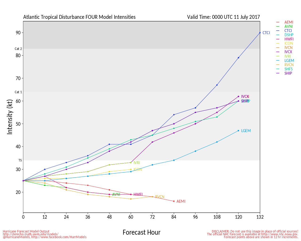
Most of the models continue to show TD#4 dissipating, the 's discussion calls out the UKMET for possibly restrengthening it in 90-120 hours. Looking at the UKMET (click "ukmo UM" on https://ruc.noaa.gov/hfip/tcgen/ ) it shows a Tropical Storm landfall near Flagler Beach in about 150 hours (July 13th)
Although other models don't show development, conditions are improving in them when it nears the Bahamas,
Discussion:
The depression is expected to retain that status for another 36 h or
so while the vertical wind shear remains relatively low at less than
15 kt. By 36-48 h, westerly vertical wind shear is forecast to
increase to around 20 kt, which should induce gradual weakening. The
small cyclone is expected to degenerate into a remnant low by 48-72
h and dissipate by 96 h. There is one important caveat to note and
that is the UKMET model, which continues to show less weakening and
even strengthening in 96 and 120 h when the system is approaching
the Bahamas. Although the other global and regional models do not
show regeneration at this time, they do however show similar
improving upper-level wind conditions east of Florida by 120 h. For
now, the official intensity forecast remains similar to the previous
advisory and the consensus model IVCN through 48 h, after which the
forecast is lower than the intensity consensus.
---
IT's not unheard of for weak depressions to fall apart and regain later, 2005 has one of the best examples of that with "TD#10".
|
Prospero
Storm Tracker

Reged: Fri
Posts: 267
Loc: Gulfport, FL
|
|
Eager for updates, even if they are not very important.
This is my favorite entertainment venue, for whatever that's worth. Yea, call me a tropical weather nerd for sure!
--------------------
Gulfport Florida Webcam - Gulfport Florida Weather Station - Clearwater Beach Cams
|
MikeC
Admin
Reged: Sun
Posts: 4543
Loc: Orlando, FL
|
|
The only thing good the long range models are for is generall pattern, staring at storm positions with the windshield wiping every other run will drive you crazy. About all its good for is that there may be something to watch x days out, and that's about it.
UKMet (and the other models) now have this system not coming back.
|
MikeC
Admin
Reged: Sun
Posts: 4543
Loc: Orlando, FL
|
|
0Z Euro run from overnight brings the remnants of TD#4 as a rain maker over South Florida thursday night, and Friday then moves it into the Gulf of Mexico, then Develops it into a Tropical storm that landfalls between Mobile and Pensacola on July 17th (Monday).
No other model does anything close.
|
MikeC
Admin
Reged: Sun
Posts: 4543
Loc: Orlando, FL
|
|
Watching the visible satellite this morning, it looks like former TD#4 may have a closed low, wind readings around it support it, but not sure if it's closed at the surface. I'd suspect the 2pm outlook may mention it at least.
|
MikeC
Admin
Reged: Sun
Posts: 4543
Loc: Orlando, FL
|
|
Floaters and Invest 04 back up for Ex-TD#4.
AL, 04, 2017071012, , BEST, 0, 225N, 641W, 25, 1011, LO
Ex Tropical Depression Four Event Related Links
SFWMD Model Plot (Animated Model Plot) SFWMD Hurricane Page
[https://flhurricane.com/floatanimator.php?year=2017&storm=4 Flhurricane Satellite Floater Animation of ExTD#4
GOES Floater
Animated Model Plot of ExTD#4
Clark Evans Track Model Plot of ExTD#4
(Animated!) Model Plots in Google Earth - In Google Maps
Clark Evans Intensity Model Plot of ExTD#4 (Animated!)
Clark Evans Track Plot of ExTD#4
Other Model Charts from Clark
Clark Evans Top 10 Analog Storms for ExTD#4
More model runs on from RAL/Jonathan Vigh's page
NRL Info on ExTD#4 -- RAMMB Info
COD Atlantic Satellite View
|
MikeC
Admin
Reged: Sun
Posts: 4543
Loc: Orlando, FL
|
|
Recon flight scheduled for noon tomorrow for Ex-TD#4.
|
MikeC
Admin
Reged: Sun
Posts: 4543
Loc: Orlando, FL
|
|
No models develop ex-td#4 in the 12Z run, although the Euro is stronger than the others when it enters the eastern Gulf and approaches Louisiana (Florida rain would be Thursday night into Friday) it does develop it before landfall in Southeastern Louisiana on Sunday.
The system is re-firing storms again this afternoon.
|


 Threaded


