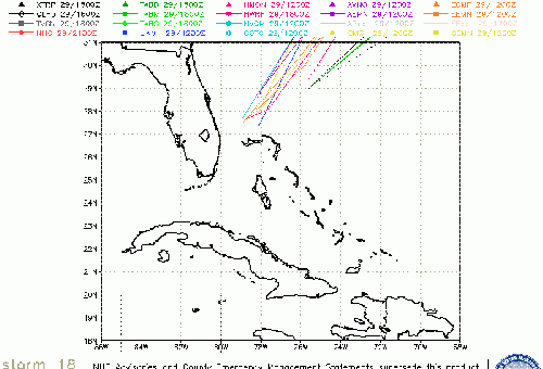
Tropical Storm Philippe has formed, therefore, Tropical Storm warnings are up for potions of Cuba and the northwestern Bahamas. Since a slight change int he track could bring more winds over portions of South Florida a tropical storm watch was issued for portions of southeastern Florida and the upper Florida Keys from Craig Key to Golden Beach.
Heavy rain and the possibility of tornadoes will exist.
From the :
. While the forecast track of the center lies about 35 miles southeast of the Upper Florida Keys and extreme southeast Florida and most of the winds are expected to remain east of the center, only a slight deviation to the west of the expected track or an increase in the size of the wind field could bring tropical-storm- force winds across these land areas. For that reason, a tropical storm watch has been issued for these areas.
The closest approach to florida is overnight tonight.
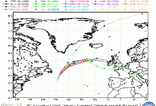
Beyond Florida and the Bahamas there's a chance it may bend back west toward DelMarVa and New England as a non-tropical system. on Monday. Heads up in that area also.
Philippe Event Related Links

SFWMD Model Plot (Animated Model Plot) SFWMD Hurricane Page
[https://flhurricane.com/floatanimator.php?year=2017&storm=18 Flhurricane Satellite Floater Animation of Philippe
GOES Floater
Animated Model Plot of Philippe
Clark Evans Track Model Plot of Philippe
(Animated!) Model Plots in Google Earth - In Google Maps
Clark Evans Intensity Model Plot of Philippe (Animated!)
Clark Evans Track Plot of Philippe
Other Model Charts from Clark
Clark Evans Top 10 Analog Storms for Philippe
More model runs on from RAL/Jonathan Vigh's page
NRL Info on Philippe -- RAMMB Info
COD Atlantic Satellite View
East Florida Links
Southeast Composite Radar Loop
(Latest Static)
South to North:
Key West, FL Radar Radar Loop
(Latest Static)
Miami, FL Radar Radar Loop
(Latest Static)
Melbourne, FL Radar Radar Loop
(Latest Static)
Jacksonville, FL Radar Radar Loop
(Latest Static)
Caribbean/South East Coast Satellite Imagery
SFWMD Radar Loop of South Florida with storm Track
SFWMD Full Florida Radar Loop with Storm Track
Area Forecast Discussions:
FLorida Keys -
Miami/South Florida -
Melbourne/East Central Florida -
Jacksonville/Northeast Florida -
Mid-Atlantic/Carolina Links
Southeast Composite Radar Loop
(Latest Static)
Charleston, SC Radar Radar Loop
(Latest Static)
Wilmington, NC Radar Radar Loop
(Latest Static)
Morehead City, NC Radar Radar Loop
(Latest Static)
Norfolk/Wakefield, VA Radar Radar Loop
(Latest Static)
Area Forecast Discussions:
Charleston, SC -
Wilmington, NC -
Morehead City, NC -
Norfolk/Virginia Beach/Hampton Roads, VA
Power Outage Maps:
South Carolina Power Outage Map
North Carolina Power Outage Map
Virginia Power Outage Map
StormCarib Reports from the Caribbean Islands
Caribbean Weather Observations
Barbados Brohav Weather Fax
Full Caribbean Radar Composite
Caribbean Broadcast Corporation (TV/Radio from Antilles)
San Juan, PR NWS Page
Various Caribbean Radio Stations
DR1 Dominican Republic Hurricanes
94L Event Related Links

SFWMD Model Plot (Animated Model Plot) SFWMD Hurricane Page
[https://flhurricane.com/floatanimator.php?year=2017&storm=19 Flhurricane Satellite Floater Animation of 94L
GOES Floater
Animated Model Plot of 94L
Clark Evans Track Model Plot of 94L
(Animated!) Model Plots in Google Earth - In Google Maps
Clark Evans Intensity Model Plot of 94L (Animated!)
Clark Evans Track Plot of 94L
Other Model Charts from Clark
Clark Evans Top 10 Analog Storms for 94L
More model runs on from RAL/Jonathan Vigh's page
NRL Info on 94L -- RAMMB Info
COD Atlantic Satellite View


 Threaded


